Showing 11423 items
matching maps
-
 Port Melbourne Historical & Preservation Society
Programme - Port Melbourne Community Festival, Maree Menzel et al, Feb 2001
Poster and program promote the two day Festival organised by a community based committee under the auspices of the Port Melbourne Neighbourhood House.Program for the 2001 Port Melbourne Community Festival. Images of Port such as sail and ferry, in pink, blue and green, A3, folded to A6 and including full program of activities, coupons and mapcelebrations fetes and exhibitions, maree menzel, pat grainger, port melbourne neighbourhood house -
 Coal Creek Community Park & Museum
Mine Map
6306.1 - Map of Outtrim mining area, with modification where damage/erasure has occurred. Shows tunnels, faults, tramways, boreholes, surface roads and (apparently) paddock boundaries and a creek. -
 Bendigo Historical Society Inc.
Book - BENDIGO ADVERTISER PERSONAL NOTICES 1896 - 1910
Hardcover book with 504 pages of personal notices published in the Bendigo Advertiser 1896 - 1910 compiled by Betty May Jackman Volume 3 some black and white photographs & a map.Betty May Jackmanbooks, catalogues, personal notices -
 Bendigo Historical Society Inc.
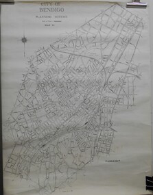
Map - JACK FLYNN COLLECTION: BENDIGO, Revised 1/01/1961
Map: Bendigo city, it has City of Bendigo Planning Scheme as the title. Showing the city within the Municipal Boundaries, also has contour lines and the Major Gullies. Revised 1.1.1962.map, bendigo, city streets, bendigo planning scheme -
Bendigo Historical Society Inc.
Map - BENDIGO (PART), No date visible
Map: Portion of Bendigo parish plan, showing from Murphy St. East to Bob St and between rail line to old saleyards to the old Heathcote line Canvas backed.map, bendigo, city streets, bendig parish plan , bendigo city streets -
 Bendigo Historical Society Inc.
Book - THE EFFECTS OF RECREATION ON THE WHIPSTICK FOREST PARK, 1983
The Effects of Recreation on the Whipstick Forest Park a Social Science III B research paper Bachelor of Arts (Social Science) Bendigo College of Advanced Education. 51 pages with maps.Anne Butlerbook, bendigo, whipstick, whipstick forest, land conservation, flora & fauna. -
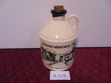 National Vietnam Veterans Museum (NVVM)
Memorabilia, Port Crock, Vietnam Memorial 1992 (Large)
Front-Vietnam Memorial site- Canberra Reverse- Picture of troops Vietnam- Black and white Side Map of Vietnam For All Those who suffered and died Vietnam 1962-1973Mt Aitken Estates-Australia Picture on reverse- Operation In Vietnamport decanter, vietnam memorial -
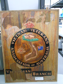 National Vietnam Veterans Museum (NVVM)
Sign, Wooden Sign, Vietnam Veterans Association of Australia
Wooden Sign with Copper Lettering for Vietnam Veterans Assoc of Australia Vistorian Branch. Map of Vietnam, Caribou Aircraft, RAR Cap Badge, Australian Flag and Crown are also depicted.vietnam veterans association of australia, wooden sign, caribou -
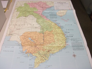 National Vietnam Veterans Museum (NVVM)
Map - Map, Vietnam and surrounding countries
Paper map of Vietnam, Laos, Thailand, Hainan Island, Cambodia & Burma. Coloured print, very detailed. Showing surrounding oceans & information on climate & population of North & South Vietnam.vietnam map -
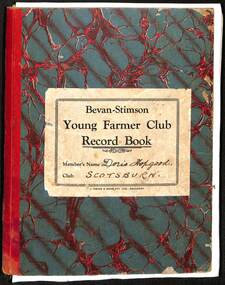 Buninyong & District Historical Society
Journal - Exercise Book, Scotsburn "Young Farmers Club Record Book" 1936 Doris Hopgood, 1934
farm life 1930'sScotsburn "Young Farmers Club Record Book" 1936 by Doris Hopgood, hardcover exercise book, containing child's observation on farm life 1937, drawings, maps, cuttings etc.farm life, sheep, scotsburn -
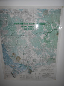 National Vietnam Veterans Museum (NVVM)
Map, Military Civic Action in Phuoc Tuy Province
Laminated map of civil action in Phuoc Tuy Province and Vung Tau Special Zone in the period of March 1970 to June 1971. Details housing, schools, hospitals & infrastructure projects.civil action, phuoc tuy, vung tau -
Tatura Irrigation & Wartime Camps Museum
Book, Albrecht Dümling, The Vanished Musicians, Jewish Refugees in Australia, 2016
Tells the stories of Jewish refugees brought to Australia, particularly those on the Prison Ship "Dunera". Emphasis on musicians.Many of the musicians were interned in camps in the Tatura Group of Internment Camps.Blue soft covered book with photos of musicians playing their instruments on front cover. There are maps, photographs, sketches of musical programmes and copies of official documents required by the refugees. 2nd copyExile Studies, Vol 14. ISBN 978-3-03-431951-3 jewish musicians - australia, jewish refugees - australia, albrecht dumling, jewish musicians, jewish refugees -
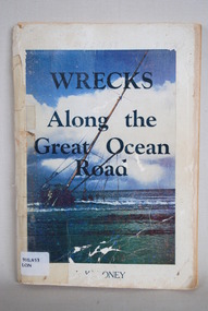 Anglesea and District Historical Society
Book, J Loney, Wrecks Along the Great Ocean Road, 1967
Book first published in 1967 dealing with the shipwrecks along the Great Ocean Road. Illustrated with both maps and photographs and with a chrononolgy of the list of wrecks from pre-1800 through to 1958.Title: WRECKS / Along the / Great Ocean / Road J.K. LONEYjack loney, dewey no 910.453, book -
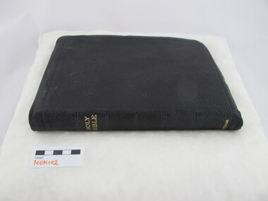 Uniting Church Archives - Synod of Victoria
Bible, The Holy Bible containing the Old and New Testaments: appointed to be read in churches
Brown leather covered bible with 1505 gilt edged pages and 6 colour maps at the back. The spine has gilt embossed text. There is a dedication stuck inside the front of the bible."METHODIST ORDER OF KNIGHTS. Presented to the Provincial High Court of Victoria and Tasmania as an Expression of Esteem and Appreciation of the many courtesies shown during the Inter-Provincial Rally held in Melbourne December 1950 - January 51 for the South-Australian Delegation" " ? Beasley Knight Grand Commander"methodist order of knights -
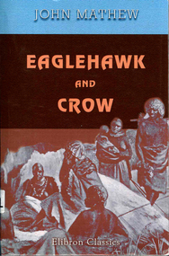 Victorian Aboriginal Corporation for Languages
Book, John Mathew, Eaglehawk and crow : a study of the Australian Aborigines, including an inquiry into their origin and a survey of Australian languages, 2005
Original text of comprehensive detail of Mathew?s observations and theories on Origin of Species of Aboriginal People, Traditional Lifestyles, Art and Social Customs. Includes maps and word lists and meanings. -
Victorian Aboriginal Corporation for Languages
Book, City of Whitehorse, City Of Whitehorse parks and reserves: names and origins, 1985
Spiral bound book released by City of Whitehorse council. Alphabetically listed placenames within the local government area, with Melway map points and brief historical references to those places.Black and white photographs, colour photographsplace names, city of whitehorse, box hill, mitcham, mont albert, blackburn, surrey hills, burwood, nunawading, forest hill -
Stawell Historical Society Inc
Map, Crocodile Gold Corp, Photographic Aerial View of Big Hill showing underground workings and surface workings and proposed Big Hill Open Pit proposal, December 2014
Crocodile Gold Corp SGM photo Map showing Magdala Decline& Wonga Decline December 2014 Produced for Public Consultation over Big Hill Open Pit Proposal. Aerial Views Stawellmining, gold, map -
 Whitehorse Historical Society Inc.
Document, Landscape Submission, c 1976
A landscape submission written for the National Trust of Australia (Victoria) for Blackburn Lake and the Bell Bird Streets.A landscape submission written for the National Trust of Australia (Victoria) for Blackburn Lake and the Bell Bird Streets. Definitions given of boundaries of the Lake area, ownership, housing and gardens. Photographs and map.A landscape submission written for the National Trust of Australia (Victoria) for Blackburn Lake and the Bell Bird Streets.blackburn lake sanctuary, waratah crescent, blackburn, jeffery street, hill street, boongarry avenue, linum street, laurel grove, acacia avenue, city of nunawading, melbourne and metropolitan board of works, furness park, camberwell grammar school -
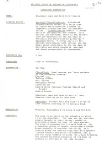
 Whitehorse Historical Society Inc.
Legal record - Document, Melbourne Metropolitan Planning Scheme, 1987
Explanatory Statement of Amendment 500 to Melbourne Metropolitan Planning Scheme, including map of area (South of Blackburn Station). To be exhibited from 2 October 1987 to 22 December 1987.roads and streets, victoria. ministry for planning and environment, city of nunawading, south parade, blackburn, blackburn road, blackburn, main street, blackburn -
Southern Sherbrooke Historical Society Inc.
Information folder
Information folder pertaining to Birdsland. Contents:/map (copy), Shire of Yarra Ranges, Birdsland Reserve/flyer, Birdsland Then and Now, advertising talk at Belgrave Library, 9 Oct 2014birdsland -
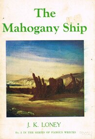 Otway Districts Historical Society
Book, The Mahogany Ship, 1974
A Spanish ship supposedly buried in sand between Warrnambool and Port Fairy, Victoria, Australia.The Mahogany Ship. J.K. Loney. 2nd ed. Dimboola (Vic); J.K. Loney; 1974. 24 p.; illus, maps. Soft cover. ISBN 0 909244 03 0mahogany ship; shipwrecks; j.k. loney; painting; warrnambool; port fairy; belfast;, mahogany ship; shipwrecks; j.k. loney; painting; warrnambool; port fairy; belfast; -
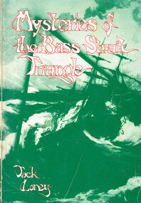 Otway Districts Historical Society
Book, Neptune Press Pty Ltd, Mysteries of the Bass Strait Triangle, 1980
Bass Strait triangle encloses a stretch of the world's most hostile seas where the ocean's mood can change without warning, threatening destruction to all who sail on it.Mysteries of the Bass Strait triangle. J.K. Loney. Belmont (Vic); Neptune Press; 1980. 112 p.; illus, maps. Soft cover. ISBN 0 909131 53 8bass strait; j.k. loney; -
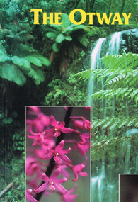 Otway Districts Historical Society
Book, Yaugher Print, The Otway Ranges, 1998
Flora and fauna found through the Otway Ranges interspersed with historical references from aboriginal occupation to the present day.The Otway Ranges.Trevor Pescott. 1st ed. Belmont (Vic); Yaugher Print; 1998. 112 p.; illus, map, bibliography. Soft cover. ISBN 0 9586562 1 5otway ranges; natural history; description; travel; geology; timber; -
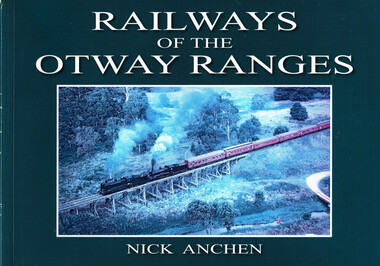 Otway Districts Historical Society
Book, Railways of the Otway Ranges, 2011
After various railways into the Otways were proposedfour separate lines were built, a crucial ingredient of the timber industry. It eventually expanded to become of the Victoria's largest.Railways of the Otways. Nick Anchen. Sierra Publishing; Ferntree Gully (Vic); 2011. ii, 96p.; illus, maps. Soft cover. ISBN 978 0 9807640 0 0.railways of the otway ranges; nick anchen; history; railways; otways; otway ranges; logging railroads; railroads, industrial; -
 Bendigo Historical Society Inc.
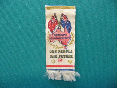
Souvenir - FEDERATION STICK PIN, 1901
Federation Stick pin with ribbon of white satin with map of Australia underneath Australian & Red Ensign flags, worded Australian Commonwealth One People One Future, fringed on bottom.event, official, federation -
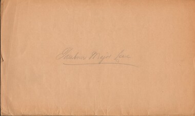 Bendigo Historical Society Inc.
Document - MCCOLL, RANKIN AND STANISTREET COLLECTION: TAMBOUR MAJOR LEASE, 1939/1940
Manilla Folder containing Lease application and correspondence for lease No. 11007 (Tambour Major). Includes Map of lease. Also references to lease Numbers 10168 and 10899. Dated September 1939McColl Rankin & Stanistreet, Charing Cross Bendigo.gold mining, miners' safety cage, tambour major lease, gold mines, bendigo tambour major -
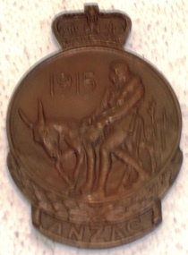 8th/13th Victorian Mounted Rifles Regimental Collection
Memorabilia - Medal, Anzac Commemorative Medalion, 1967
Medallion was issued to Miss Edna Huf of Albury, sister of No 533 Sergeant Carl Wilhelm Huf, 7th Battalion AIF who died at sea on HMT "Royal George" on 13 May 1915 of wounds received at Gallipoli and buried in Chatly Cemetery Egypt. Huf was aged 20. Miss Edna Huf donated the medallion together with other items to 8/13th Victorian Mounted Rifles Collection prior to her death at Albury.Part of a collection of items relating to the service and death of a single Australian soldier in WWI which was kept by his sister and passed to a local military collection for keeping shortly before her death in Albury.Bronze medallion featuring Simpson and donkey on obverse and map of Australia and New Zealand on reverse. Issued in 1967 to surviving persons who had served at Gallipoli and NOK of deceased servicemen. Inscribed on lower portion of reverse "CW Huf"huf, gallipoli, anzac commemorative medalion, anzac day, wwi, world war one, anniversaries, medals, numismatics, donkeys, simpson -
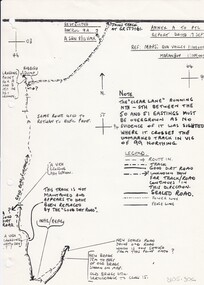 8th/13th Victorian Mounted Rifles Regimental Collection
Document
In 1988, as part of a Defence of Mainland Australian policy, defence of facilities of strategic importance in northern Australia were allocated to Army Reserve units. ‘A’ Squadron was allocated the defence of Tindal Air Force base located 15 KM outside Katherine in Northern Territory. Consequently the Squadron deployed on Exercise ‘Northern Explorer’ to gain first-hand knowledge of operating conditions for mounted and dismounted patrolling in the area.Rare example of a patrol report conducted by soldiers of a Victorian Army Reserve regiment while exercising in Northern Territory.Report of reconnaissance patrol conducted by soldiers of 'A' Squadron 8/13 Victorian Mounted Rifles during Exercise 'Northern Explorer, Northern Territory. 13 pages plus sketch map. -
 City of Greater Bendigo - Civic Collection
Booklet, Cambridge Press, City of Bendigo Handbook 1978, 1978
Handbook for residents with information about rates, garbage collection, numbering houses, building, dog registration etc.Black and white printed, seven page handbook for residents. Centre page illustrated map. Front cover; photo of Sacred Heart Cathedral. Handbook is folded in centre. Stapled on fold. councillor r turner, mayor turner, city of bendigo -
 Kilmore Historical Society
CHAMBERS INFORMATION FOR THE PEOPLE VOL 1, 1848
Faded brown loose cloth cover with embossed detailing on cover and spine 'Chambers information for the People, Vol 1 Sciences - Arts & C.' 809 pages ; Maps; Illus; 27cm Handwritten inscription on first page - '36, 41, 040 CHA R 28' Stamp on various pages 'Kilmore Mechanics Institute' science, arts, kilmore mechanics institute library.