Showing 11430 items
matching maps
-
 Ringwood and District Historical Society
Pamphlet, Carter Real Estate, Carter & Son Pty Ltd Real Estate - Client newsletter 1995, Sep-95
Newsletter to clients including article related to the "Australia Remembers" celebrations.|The single page has ads for C.E. Carter and A.T. Miles plus The Mocha Cafe.3 A4 pages headed Client Newsletter - Carter & Son Pty Ltd Real Estate; Single photocopied page with ads and map +Additional Keywords: Carter, Richard / Miles, A.T. -
 Ringwood and District Historical Society
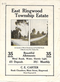
Flyer, Subdivisional Land Sale Brochure, East Ringwood Township Estate, Vic. - 1923
Bi-folded double sided land subdivision sale advertisement with location map and summary of local facilities and services. Includes two additional images of allotment plan with subsequent handwritten notations.Subdivision includes Mount Dandenong Road, Grey Street, and Eastfield Road. Agent - C.E. Carter, Bank Chambers, Main Street, Ringwood. Phone Ringwood 24. -
 Ringwood and District Historical Society
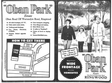
Flyer, Land Sale Advertisement, Oban Park Estate, Ringwood, Vic. - 1969
One double-sided and two single-sided pages advertising Oban Park Estate land sale, including terms of sale, locality map, subdivision features and summary of local services.Subdivision includes Oban Road, Terrigal Close, Dorelaw Drive (later Melview Drive), Naroo Court, Barook Court, and Lockhart Road. Agents in Conjunction: E. Wachman, Melbourne, Hutchinson Real Estate, Ashwood, and A.W. Dickson, 136 Whitehorse Road, Ringwood (Phone) 870-6007 A.H. 882967. Separate newspaper advertisement (digital only) shows agents - Hutchison Real Estate (Telephone 277-2326) and Michelson Gelfand Pty Ltd (Telephone 53-8151). -
 Bendigo Military Museum
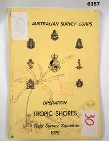
Administrative record - Royal Australian Survey Corps - Operation Tropic Shores, 1 Field Survey Squadron 1978, 31 Aug 1978
Operation Tropic Shores was conducted in 2 phases, Sep 1977 and May / Jun 78. The Operation was the field completion of Cape York 1;50,000 Mapping North of latitude 15 degrees S. Plotting was undertaken by 2, 4 and 5 Fd Svy Sqns with 1Fd Svy Sqn undertaking the mounting and Management of the field completion phase. Re-visiting and targeting of existing trig stations was also carried out as an opportunity task.Booklet, A4 cream cardboard cover, stapled Left Hand side, containing a report and plotted maps. Cover has Title and the Badges of the Australian Army Corps who participated in the Operation. 2 fd svy sqn, 4 fd svy sqn, 5 fd svy sqn, royal australian survey corps, 1 field survey squadron, 1fd svy sqn, rasvy, fortuna, army survey regiment, army svy regt, asr -
Warrnambool and District Historical Society Inc.
Document, Wollaston sale, 1919
This is a poster advertising the sale of part of the Wollaston Estate in Warrnambool in 1919. The sections for sale were Allotments 1, 18 and 19 which included the Wollaston Homestead. The original Wollaston property of 679 acres was selected by Thomas Manifold in the late 1840s. This land, on the northern side of the Merri River, near the Woodford Road was three kilometres from the Warrnambool town. The first farmer we know who leased the property was William Simpson. Walter Manifold inherited the property and he took it over in 1884. The swing bridge he built in 1890 still stands today. In 1919 the Closer Settlement Board of Victoria acquired Wollaston and 17 lots were sold to returned soldiers for farming purposes. By 1930 there were only five soldier settlers remaining. In 2009 further subdivision took place with lots sold for residential purposes. The homestead allotments were sold separately in 1919 with various owners of the homestead itself recorded since that time. This poster is of interest as it shows the areas of the Wollaston Estate which were sold in 1919. The history of this estate is well-documented and of importance in the history of Warrnambool. This is a sheet of paper with red and black printing and a map of the Wollaston Estate which is photo-lithographed. The sheet has been folded three times. It has some small tears at the top of the page. wollaston, history of warrnambool, walter manifold -
 Bendigo Military Museum
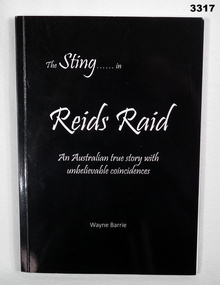
Book - BOOK, BOER WAR, The Sting ........ in Reids Raid, 2018
From the book cover: Reids Raid is a true story with all the qualities of a good Aussie yarn. It occurred in the 1899 - 1902 Boer War in South Africa.Soft cardboard cover, white print on glossy black background on front, spine & back. 107 pages cut, plain, white, illustrated with black & white & sepia photos, maps & illustrated.books-military-history, boer war -
 Bendigo Military Museum
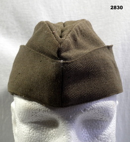
Headwear - CAP, FORAGE, C.WW2
Khaki forage cap, bottom section joins with Two copper coloured buttons with map of Australia surmounted by a crown, bearing legend, “Australia Military Forces” lined with brown cotton fabric.Handwritten on label inside: “182[3 or 5?] 8 / N McGregor”uniforms - army, costume - male - headwear, metalcraft - copperware, passchendaele barracks trust, forage -
 Bendigo Military Museum
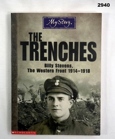
Book - BOOK, TRENCHES, Scholastic Children's Books, The Trenches - Billy Stevens, The Western Front 1914-1918, 2002
Book, paperback. Front cover has portrait of a British Soldier in front of other British Soldiers charging up out of a trench. 139 pages, illustrated with black & white photos & maps.books, the trenches -
 Bendigo Military Museum
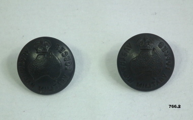
Uniform - BUTTONS ARMY, 1950's
Belonged to Capt Warick Rosenthal No TX6321 AAMC. Refer 622.3, 775. .1) Uniform button, metal, black, round domed shape. Has a crown over map of Aust with lettering "Australian Military Forces." one lug on rear. .2) Same as .1)uniforms, army, buttons -
 Bendigo Military Museum
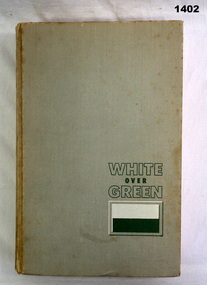
Book, The Unit Historical Editorial Committee, White Over Green. The 2/4th Battalion & Reference to the 4th Battalion, 1963
Very light green hard cover, print is dark green ink. Image of 2/4th Battalion cover patch. 364 pages, illustrated with black & white photos, drawings & maps.Label: Rev A J & C E Kendallbooks, military history, biography -
 Bendigo Military Museum
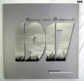
Book, Department of Veteran's Affairs, Bapaume and Bullecourt 1917, Australians on the Western Front, 2007
Hardcover, cardboard, pale grey-purple. "1917" title has black and white photo of barbed wire and clouds inset. 428 pages, includes black and white photos and maps and diagrams.Includes label with previous owners' names and address.books, military history -
 Bendigo Military Museum
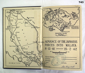
Book, Angus & Robertson Ltd, Why Singapore Fell, 1944
249 page royal blue buckram hardcover book. Cut edged pages, gold print on spine, maps on front and back end pages. Includes B&W photos and illustrations.Handwritten in blue ink on front flyleaf "Mrs Mary Hall". Blue stamp on front flyleaf "Returned & Services League Memorial Hall Bendigo".books, military history, singapore -
 Bendigo Military Museum
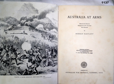
Book, Australia at Arms, 1955
Green hard cover buckram with gold print on cover. Gold design on cover. Black and white photos and prints throughout book. Pages 265 Inside covers - cover maps and illustrations.books, miltary history -
 Bendigo Military Museum
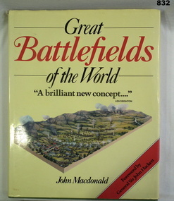
Book, John Macdonald, Great Battlefields of the World, 1984
Book, green buckram with gold print & dust jacket. Jacket background is yellow with red & black print & 3D drawing of a battlefield. 200 pages. Illustrated with maps, 3D drawings & photos.From Bishop Noel Daly's collections 2004books, military, history -
 Bendigo Military Museum
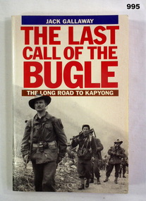
Book, The Last Call of The Bugle, 1994
Relates to the Korean WarSoft cover- white with black and white photo of soldiers on front. Title in red on spine and front. 312 pages. Illustrated with black and white photos and maps. Contents relate to Korean War."FRANCIS W. DEAN BEM" on fly leaf. books, military history -
 Bendigo Military Museum
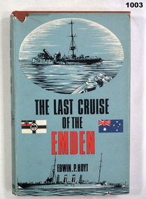
Book, The Last Cruise of the Emden, 1967
Brown buckram hard cover, black print. Dust cover paper blue, red, white, black Black print and maps on white paper. Black and white photos. Pages 242MARK LEWIS (inside cover) books, military history -
Glenelg Shire Council Cultural Collection
Souvenir - Tea Towel, Dorset, UK Tea Towel, n.d
Cotton tea towel. Green border, orange inner border with green leaves and yellow flowers. 'Dorset' (UK) - showing map and image from Portland, Dorset and other Dorset sites.Front: 'Made in Britain' 'Vista' 'all cotton' - black, bottom border. -
Glenelg Shire Council Cultural Collection
Photograph - Photograph - Maritime Discovery Centre Gift Shop, c. 1998
Coloured photograph: inside Maritime Discovery Center, gift shop on left, young man standing in front of the information board about Great South West, map of Glenelg Shire on right. -
4th/19th Prince of Wales's Light Horse Regiment Unit History Room
Booklet, Manual of Map Reading, Air Photo Reading & Field Sketching Part 2 Air Photo Reading
A yellow dust jacketed hard covered booklet enabling officers and NCO to make use of air photographs to support the map, and support ground recon and to use when ground recon is not possibleWO Code No 9484air photo reading -
 Kiewa Valley Historical Society
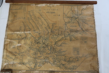
Map - Railway Map of Victoria, Amended to 1/11/1945
Railways began in the 1850s and were privately owned and operated. Later they were taken over by the Victorian Government reaching a peak in the early 1940s.Steam trains were followed by electric trains with both running after the war in 1945.Bright was the closest station to the Kiewa Valley but road transport was used more often as the Kiewa Valley Highway was improved with the construction of the Kiewa Hydro Electric Scheme. To travel to Melbourne or Sydney by train residents went via Wodonga/Albury where they also did their shopping.Plastic on parchment with detailed railway routes (in green) across Victoria including each district's 'Road Foremen' and 'Depots'. There is a length of flat wood attached by 10 tacks across the top of the mapvictorian railways 1945, trains, transport -
 Ringwood and District Historical Society
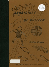
Book, Aborigines of Bulleen, 1989
Soft-cover book with indigenous artwork on brown cover with maps, drawings and photographs outlining the history of local indigenous people who inhabited the area which became the City of Doncaster and Templestowe. -
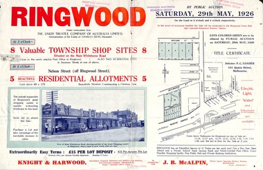 Ringwood and District Historical Society
Flyer, Township Shop Sites and Residential Allotments Sale By Public Auction, Ringwood, Victoria - 1926
Advertisement for eight township shop sites and five residential allotments for sale by Public Auction on the land in Ringwood on Saturday, 29th May, 1926, with location map, and summary of local features and services. Locality plan highlights sites for auction in Nelson Street, Seymour Street and Whitehorse Road. (Agents) Knight & Harwood, 315 Collins Street, Melbourne, Phones 10615, 10616 Central, in conjunction with J.B. McAlpin, Estate Agent, Opposite Railway Station, Ringwood, Phone Ringwood 7. -
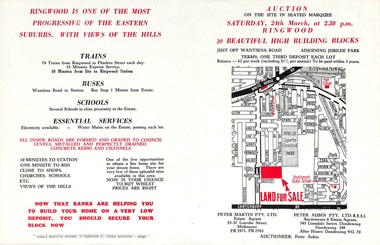 Ringwood and District Historical Society
Flyer, Land Auction Advertisement adjoining Jubilee Park, Ringwood, Victoria - 1956
Folded double-sided brochure advertising residential land sale auction on Saturday 24th March (1956), with locality map and subdivision layout, terms of sale, and summary of local features and services. Subdivision includes Reilly Street Ringwood, and Philip Street, Daisy Street, and Lorienne Street Heathmont. Surveyors - Messrs Little and Brosnan. Agents in Conjunction - Peter Martin Pty. Ltd., Estate Agents, 55-57 Latrobe Street, Melbourne (Phone) FB 3571, FB 2783, and Peter Aubin Pty. Ltd. R.E.S.I., Auctioneers & Estate Agents, 345 Lonsdale Street, Dandenong (Phone) Dandenong 340, After Hours, Dandenong 932, 70. -
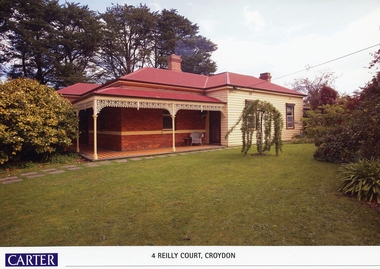 Ringwood and District Historical Society
Memorabilia, History of Kleinert's Homestead, 4 Reilly Court, Croydon, Victoria
Collection of maps and title deeds of Kleinert's 1886 homestead - 22 pages in pockets in black plastic spiral binder, compiled by Richard Carter, November 2008. Photocopies of title deeds and subdivisions. -
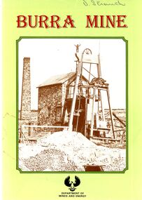 Bendigo Historical Society Inc.
Book - STRAUCH COLLECTION: BURRA MINE
Small souvenir booklet from Burra Mine, printed by D J Woolman, Director and Government Printer, South Australia February 1987 for Department of Mines and Energy, contains photographs & maps.place, mining site, burra sa, south australia-history-mining-burra -
 Bendigo Historical Society Inc.
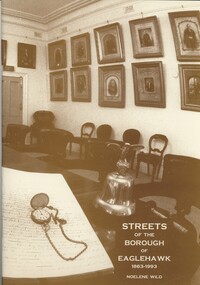
Book - STREETS OF THE BOROUGH OF EAGLEHAWK 1863-1993, c1994
Streets of the Borough of Eaglehawk 1863-1993. Soft cover. Publisher: Bendigo Modern Press, Bendigo. ISBN: 0 646 17049 X. 50 pages. Illustrations: photographs, illustrations & map.Noelene Wildbook, eaglehawk, streets, eaglehawk history, street of eaglehawk, pioneers eaglehawk -
Bendigo Historical Society Inc.
Map - TOWNSHIP OF SANDHURST MAP
Map township of Sandhurst Portion B Bendigo Creek. Victoria zincographed at the Crown land's office, nos 54/21-57/12 Melbourne, April 21st 1857 (by G. Collis). -
Port Melbourne Historical & Preservation Society
Book, Meyer Eidelson et al, Walks in Port Phillip - A guide to the cultural landscapes of a city, Jan 2001
Book produced under a Federation grant. Five of the trails are associated with benches located on the foreshore.'Walks in Port Phillip - A guide to the cultural landscapes of a city' by Meyer EIDELSON. Small blue soft-cover book with seven guided walks and maps. 2001. 82pp with fold-in back coverSigned by author on title page 'Meyer'piers and wharves - station pier, immigration, piers and wharves - lagoon pier, utilities - gas, swallow & ariell ltd, natural environment - beaches and foreshore, natural environment - lagoon, liardet family, australian aborigines, meyer eidelson, vincenzo coluccio, rosa coluccio, pat grainger, gasworks -
Port Melbourne Historical & Preservation Society
Essay, Nancy U'REN, The Early Growth and Deveopment of Sandridge, 1976
The Early Growth and Deveopment of Sandridge, by Nancy U'REN 1976 - Master of Arts degree thesis containing early maps and photographs. Bound; dark blue cover with title lettered in gold on spine.local government - borough of sandridge, built environment, nancy u'ren nee morris -
Port Melbourne Historical & Preservation Society
Flyer, City of Port Phillip, City of Port Phillip, Community News Bulletin. No 1 July 1994, Jul 1994
First community news bulletin from new City of Port Phillip after amalgamation.City of Port Phillip, Community News Bulletin. No 1 July 1994 . A4 white flyer with blue printing text on one side and yellow and blue map of Port Phillip on reverse.local government - city of port phillip, des clark, lynne wenic, geoff vincent, jon hickman