Showing 10462 items
matching plans
-
 Whitehorse Historical Society Inc.
Article, Council updating City records, 1993
City of Nunawading is updating its records and introducing a new high-tech computer system.City of Nunawading is updating its records and introducing a new high-tech computer system. The updating co-insides with the planned introduction of Freedom of information to local government from January 1994.City of Nunawading is updating its records and introducing a new high-tech computer system. local government, city of nunawading, miriams, stephanie, bridges, mike -
 Whitehorse Historical Society Inc.
Letter - Correspondence, Schwerkolt Cottage and Orchard site, 14/11/2006 12:00:00 AM
Letter from Heritage Victoria to Mark Fawcett, City of Whitehorse, 16 November 2006 .Letter from Heritage Victoria to Mark Fawcett, City of Whitehorse, 16 November 2006 . Re. inclusion of Schwerkolt Cottage and orchard site in the Victorian Heritage Inventory, with plan and aerial photographLetter from Heritage Victoria to Mark Fawcett, City of Whitehorse, 16 November 2006 . fawcett, mark, schwerkolt cottage & museum complex, historic sites -
University of Melbourne, Burnley Campus Archives
Work on paper (item) - Student Work, Anne Austin, Jeffrey Street Design Brief, December 2013
Created as an assignment for HORT90035, 'Landscape Construction and Graphics,' a subject at Burnley Horticultural College coordinated by Andrew Laidlaw. Only the design brief is present however and the other components like the masterplan, documentation plan and site analysis are all missing. assignment, landscaping, burnley, burnley horticultural college, landscape construction and graphics, hort90035 -
 Federation University Historical Collection
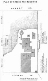
Book - Annual Report 1880, The School of Mines Ballaarat Annual Report, 9 February, 1880, 1880
The School of Mines Annual Report, 9 February, 1881, Additional Examination Statute 1880, Balance Sheet, Certificates Granted by Council, Donations and Fees - carriage of, Extracts from Visitors' Book, Fees, Form of Bequest, Honorary Correspondents, Life Governors, Mining and Mineral Contributions Invited - Paper of Particulars, Museum - open to visitors, Office Bearers, Obituary, Report of the Lecturer in Mathematics, Report of the Lecturer in Mining-Land- and Engineering-Surveying, Report of the Lecturer in Mechanical Engineering, Report of the Lecturer in Telegraphy, Report of the Curator of the Museum (with Plans), Report of the Superintendent of Laboratories, Subjects and Lecturers, Subjects and Examiners, Statement of Receipts and Expenditure for the year 1880, Subscriptions and Donations from 1 January to 31 December 1880, The Lal-Lal Iron Ore Deposits - (with Section and Plan)Pale green booklet of 70 pages, Annual Report 1880. Image of Guage Test Tower, Image of The School of Mines, Plan of Ground and Buildings - Albert Street, The School of Mines Ballaarat - The Museum - Plan of Groundfloor, Image of the Lal-Lal Iron Ore Deposits, Moorabool Riverthe school of mines, annual report, additional examination statute 1880, balance sheet, certificates granted by council, donations and fees - carriage of, extracts from visitors' book, fees, form of bequest, honorary correspondents, life governors, mining and mineral contributions invited-paper of particulars, museum open to visitors, office bearers, obituary, report of the lecturer in mathematics, report of the lecturer in mining-land and engineering-surveying, report of the lecturer in mechanical engineering, report of the lecturer in telegraphy, report of the curator of the museum (with plans), report of the superintendent of laboratories, subjects and lecturers, subjects and examiners, statement of receipts and expenditure for the year 1880, subscriptions and donations from 1 january to 31 december 1880, the lal-lal iron ore deposits-(with section and plan), obituary - sir redmond barry - arthur leahy - jacob upfold - john day, mr james oddie, dr. r. f. hudson, john victor, chas. wm. thomas, w. h. shaw, walter d. campbell, ferdinand m. krause, joseph flude, geo. perry, w. hy. barnard, examination statute, his excellency sir wm. f. drummond jervois, charles h. pearson, t. brodribb, professor pepper, james mitchell, robert adam, wm. lant carperter, h. b. de la poer wall, w. h. brokenshire, arthur parker, henry parkinson, c. davies, simon richards, c. v. gorton, c. r. blackett, david jones, wilberforce dyke, ferdinand krause, ballarat school of mines museum, ballarat school of mines museum plan, lal lal ore deposits, moorabool river, william land carpenter, william jervois, william henry tbarnard -
 Warrnambool and District Historical Society Inc.
Documents, Late 20th, early 21st centuries
These ten documents (maps, plans, photographs) mostly come from the Warrnambool City Council and most contain information on sub-divisions and titles of properties in areas around the Central Business District of Warrnambool. The dates range from 1986 to 2006. These maps, plans and photographs are of some interest as they give historical details of subdivisions in Warrnambool and date from the late 20th century. .1 This is a laminated map of the boundaries of Local Governments in Victoria. It is Sheet I of 2 and has red and blue pencil markings and black boundary markings. .2 This is a copy of a plan of a survey in black and white markings on paper. .3 This is a plan of the title details of Section 19 Warrnambool. It has black printing on buff-coloured paper. .4 This is a plan of the allotments in part of the Central Business District of Warrnambool. It is printed in black and white. .5 This is a 2006 coloured aerial photograph of the harbour at Warrnambool – Breakwater etc. .6 This is a 2006 coloured aerial photograph of the Lake Pertobe area in Warrnambool .7 This is a coloured aerial photograph of Warrnambool’s streets over-stamped with road numbers in large blockings. .8 This is a plan showing the title details of Section 11 in Warrnambool. It has black printing on buff-coloured paper. .9.1 This is a plan of sub-divisions in parts of Crown Allotments 38 & 39 in Warrnambool. It has green, pink and yellow markings with black printing. .9.2 This is a plan of the sub-divisions in parts of Allotments 38 & 39 in Warrnambool. It has pink, yellow and blue markings with black printing. It is somewhat faded. warrnambool c.b.d. maps and plans, history of warrnambool -
Whitehorse Historical Society Inc.
Article, Many Questions on Land, 1/09/2014 12:00:00 AM
The Victorian State Governme.nt will protect 2 parcels of land totalling 15.4 ha. of the Healesville Freeway Reservation as Crown Land.The Victorian State Government will protect 2 parcels of land totalling 15.4 ha. of the Healesville Freeway Reservation as Crown Land and the planned walking and cycling path, running it's entire length, will go ahead.The Victorian State Governme.nt will protect 2 parcels of land totalling 15.4 ha. of the Healesville Freeway Reservation as Crown Land.healesville freeway reservation, cycling path, walkinig path -
Whitehorse Historical Society Inc.
Map, Plan of special survey selected by H. Elgar Esq, 1841
Photocopy of plan and listing of corner stakes.Photocopy of plan and listing of corner stakes. Note on verso: Plan of special survey selected by H. Elgar Esq in the Parishes of Boroondara and Nunawading, County of Bourke. Surveyed by T.H. Nott (?Sydney) 31 May 1841. Boroondara Special Survey B.17, with attached descriptive note by T. H. Nott.Photocopy of plan and listing of corner stakes. maps, parish of boroondara, parish of nunawading, elgar, h, nott, t.h. -
Whitehorse Historical Society Inc.
Document, Mitcham Shopping Centre redevelopment, 1960s-1970s
Collection of papers relating to the Mitcham Chamber of Commerce proposal for redevelopment of Mitcham Shopping Centre.Collection of papers relating to the Mitcham Chamber of Commerce proposal for redevelopment of Mitcham Shopping Centre, in particular, parking, and reconstruction of Whitehorse Road by the Country Roads Board. Incl. correspondence, plans, news cuttings.Collection of papers relating to the Mitcham Chamber of Commerce proposal for redevelopment of Mitcham Shopping Centre.mitcham shopping centre, whitehorse road, mitcham, mitcham chamber of commerce, armstrong, raleigh edward, car parks, victoria. country roads board -
 Kiewa Valley Historical Society
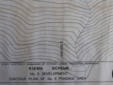
Plans - Kiewa Works Area and Environs
State Electricity Commission of Victoria constructed the Kiewa Hydro Electric Scheme from the late 1940s to 1961. These plans were used during the construction.Plans and Maps were used during the construction of the Kiewa Hydro Electric SchemeTransparent with blue tinge plans/maps created by the SECV during the construction of the Kiewa Hydro Electric Scheme. 1. Kiewa Scheme No 5 Development Contour Plan of No 5 Pondage Area 2. Mt Beauty Township 3. Kiewa Scheme No 1 Development - McKay Creek Area, Construction Layout 4. Kiewa Works and Environs 5. North Eastern Victoria and Adjoining Snowy Mountains Regionsecv, kiewa hydro electric scheme plans -
 Kew Historical Society Inc
Plan, Borough of Kew Detail Plan No.1577, 1904
The Melbourne and Metropolitan Board of Works (MMBW) plans were produced from the 1890s to the 1950s. They were crucial to the design and development of Melbourne's sewerage and drainage system. The plans, at a scale of 40 feet to 1 inch (1:480), provide a detailed historical record of Melbourne streetscapes and environmental features. Each plan covers one or two street blocks (roughly six streets), showing details of buildings, including garden layouts and ownership boundaries, and features such as laneways, drains, bridges, parks, municipal boundaries and other prominent landmarks as they existed at the time each plan was produced. (Source: State Library of Victoria)This plan forms part of a large group of MMBW plans and maps that was donated to the Society by the Mr Poulter, City Engineer of the City of Kew in 1989. Within this collection, thirty-five hand-coloured plans, backed with linen, are of statewide significance as they include annotations that provide details of construction materials used in buildings in the first decade of the 20th century as well as additional information about land ownership and usage. The copies in the Public Record Office Victoria and the State Library of Victoria are monochrome versions which do not denote building materials so that the maps in this collection are invaluable and unique tools for researchers and heritage consultants. A number of the plans are not held in the collection of the State Library of Victoria so they have the additional attribute of rarity.Original survey plan, issued by the MMBW to a contractor with responsibility for constructing sewers in the area identified on the plan within the Borough of Kew. The plan was at some stage hand-coloured, possibly by the contractor, but more likely by officers working in the Engineering Department of the Borough and later Town, then City of Kew. The hand-coloured sections of buildings on the plan were used to denote masonry or brick constructions (pink), weatherboard constructions (yellow), and public buildings (grey). MMBW Plan No.1577 includes some of the most significant houses in Kew: Herbert Henty’s ‘Roxeth’ (now part of Trinity Grammar), ‘Butleigh Wooton’, ‘Bokara’ and ‘Harrow’. It also includes the streets that have since changed their names. That part of College Parade linked to Glenferrie Road is now named College Place, College Parade now extends further north, and Charles Street did not yet reach Barkers Road. Roxeth is one of a number of Henty houses in Kew. Herbert Henty made his home here and was elected a member of Kew Municipal Council in 1864 and mayor in 1868-69. Walter Henry Serle, of Harrow served in the First World War. He was awarded the Military Medal ‘’For conspicuous bravery and devotion to duty. On 29th September near BELLICOURT he showed the greatest bravery and determination when his platoon was attacked by enemy bombing parties. It was due largely to his personal efforts that all the attacks were repulsed. Until wounded, his utter disregard of personal safety and boldness in dealing with the attacks were the means of saving the situation and were an inspiring example to his men.’melbourne and metropolitan board of works, detail plans, maps - borough of kew, mmbw 1577, cartography -
 Kew Historical Society Inc
Plan, Melbourne & Metropolitan Board of Works : Borough of Kew : Detail Plan No.1563, 1905
The Melbourne and Metropolitan Board of Works (MMBW) plans were produced from the 1890s to the 1950s. They were crucial to the design and development of Melbourne's sewerage and drainage system. The plans, at a scale of 40 feet to 1 inch (1:480), provide a detailed historical record of Melbourne streetscapes and environmental features. Each plan covers one or two street blocks (roughly six streets), showing details of buildings, including garden layouts and ownership boundaries, and features such as laneways, drains, bridges, parks, municipal boundaries and other prominent landmarks as they existed at the time each plan was produced. (Source: State Library of Victoria)This plan forms part of a large group of MMBW plans and maps that was donated to the Society by the Mr Poulter, City Engineer of the City of Kew in 1989. Within this collection, thirty-five hand-coloured plans, backed with linen, are of statewide significance as they include annotations that provide details of construction materials used in buildings in the first decade of the 20th century as well as additional information about land ownership and usage. The copies in the Public Record Office Victoria and the State Library of Victoria are monochrome versions which do not denote building materials so that the maps in this collection are invaluable and unique tools for researchers and heritage consultants. A number of the plans are not held in the collection of the State Library of Victoria so they have the additional attribute of rarity.Original survey plan, issued by the MMBW to a contractor with responsibility for constructing sewers in the area identified on the plan within the Borough of Kew. The plan was at some stage hand-coloured, possibly by the contractor, but more likely by officers working in the Engineering Department of the Borough and later Town, then City of Kew. The hand-coloured sections of buildings on the plan were used to denote masonry or brick constructions (pink), weatherboard constructions (yellow), and public buildings (grey). This plan covers the area between Barkers Road, Wrixon Street, Sackville Street and Brougham Place, much of it now occupied by Carey Baptist Grammar and Preshil schools. This was an area of large and prestigious homes in 1903, some with formally laid-out gardens, such as ‘Tower Hill’ and ‘Opawa’. ‘Kalimna’ was built in 1890-91 for William H. Jarman, an accountant, and ‘Blackhall’ at the same time for W.H. Roberts. Blackhall was to be acquired by the Salvation Army in 1915 and renamed ‘Catherine Booth Girls’ Home’. The Home accommodated girls, aged between 4 and 16. Kalimna and Blackhall are of significance as typical and intact late Victorian mansions and as such are two key Victorian buildings to have been built in Kew. Both Blackhall and Kalimna are now part of Preshil. ‘Fairview’ was for a long time occupied by the Sisters of St. Joseph of Cluny as a care home for the elderly, but it is now part of Carey Grammar School, as are the grounds of ‘Wagga Merne’, ‘Weemutta’, ‘Blakely’, ‘Daheim’ and ‘Mildura’ (later ‘Urangeline’), the last being particularly impressive in 1903, with a tennis court, conservatory, outhouses, and two bathrooms!melbourne and metropolitan board of works, detail plans, mmbw 1563, cartography -
Whitehorse Historical Society Inc.
Map, Proposed Smoke-House Schwerkolt Cottage, 11/07/1975 12:00:00 AM
Plans of proposed Smoke-house for Schwerkolt Cottage drawn by the City of Nunawading. Scale 10 feet to anPlans of proposed Smoke-house for Schwerkolt Cottage drawn by the City of Nunawading. Scale 10 feet to an inch.Plans of proposed Smoke-house for Schwerkolt Cottage drawn by the City of Nunawading. Scale 10 feet to an smoke houses, schwerkolt cottage & museum complex -
 Kew Historical Society Inc
Plan - Subdivision Plan, Riversdale Estate, 1939
The Kew Historical Society collection includes almost 100 subdivision plans pertaining to suburbs of the City of Melbourne. Most of these are of Kew, Kew East or Studley Park, although a smaller number are plans of Camberwell, Deepdene, Balwyn and Hawthorn. It is believed that the majority of the plans were gifted to the Society by persons connected with the real estate firm - J. R. Mathers and McMillan, 136 Cotham Road, Kew. The Plans in the collection are rarely in pristine form, being working plans on which the agent would write notes and record lots sold and the prices of these. The subdivision plans are historically significant examples of the growth of urban Melbourne from the beginning of the 20th Century up until the 1980s. A number of the plans are double-sided and often include a photograph on the reverse. A number of the latter are by noted photographers such as J.E. Barnes.The Riversdale Estate in Hawthorn created a subdivision of 20 allotments bordering on Riversdale Road and Riversdale Court (which was created by the subdivision). The Locality Plan at right lists the major public buildings in the area: Burnely Horticultural Gardens, Hawthorn Tram Depot and Railway Station, Scotch College and the River Yarra and The Boulevard.subdivision plans - hawthorn, riversdale estate -
 Kiewa Valley Historical Society
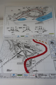
Plans - Southern Hydro - Bogong Power Development
Southern Hydro owned the Kiewa Hydro Electric Scheme in May 2006 when these plans were created. The Site No. 1 and Site No. 2 are part of the Bogong Power Development Bogong Power Development is part of the Kiewa Hydro Electric SchemeLaminated A3 plans mostly black and white but with a little color and surrounded by a grid.(Also see KVHS 1439) 1. Tunnel and Civil works / Commissioners Lodge Site Plan 1: Site No. 1 / TBN /Water /Supply / Reservoir Site 2. Tunnel and Civil Works / Pedestrian Diversion Access Paths / and Tracks: Site No. 2 / Lake Guy Site / Bogong Victoriabogong power development, southern hydro 2006 -
Port Melbourne Historical & Preservation Society
Plan - Port Melbourne Town Hall, Engineering Department, City of Port Melbourne, 1915
Plan of new (1915) Town Hall, Port Melbourne. Foundation plan, ground plan, plan of balconies.port melbourne town hall -
Whitehorse Historical Society Inc.
Pamphlet, Morack Public Golf Course, c1985
Pamphlet describing the Morack Public Golf Course in Vermont South.Pamphlet describing the Morack Public Golf Course in Vermont South. Its history is outlined and its proposed development. Course maintenance and watering systems are described. The verso is a detailed plan of the course.Pamphlet describing the Morack Public Golf Course in Vermont South. morack golf course, dandenong valley metropolitan park -
 Kew Historical Society Inc
Plan - Subdivision Plan, Doona Estate, Toorak, 1929
The Kew Historical Society collection includes almost 100 subdivision plans pertaining to suburbs of the City of Melbourne. Most of these are of Kew, Kew East or Studley Park, although a smaller number are plans of Camberwell, Deepdene, Balwyn and Hawthorn. It is believed that the majority of the plans were gifted to the Society by persons connected with the real estate firm - J. R. Mathers and McMillan, 136 Cotham Road, Kew. The Plans in the collection are rarely in pristine form, being working plans on which the agent would write notes and record lots sold and the prices of these. The subdivision plans are historically significant examples of the growth of urban Melbourne from the beginning of the 20th Century up until the 1980s. A number of the plans are double-sided and often include a photograph on the reverse. A number of the latter are by noted photographers such as J.E. Barnes.The Doona Estate subdivision of 1929 created 11 new allotments bordered by Glenferrie Road, Stonnington Place, Cross and Church Streets. On the right of the plan, the location of ‘State Govt. House’ is noted. Stonnington was to be maintained as Victoria’s Government House until 1931, two years after the Doona Estate subdivision was released.subdivision plans - toorak, doona estate -
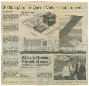 Queen Victoria Women's Centre
Newspaper clipping, Wayne Taylor, $600m plan for Queen Victoria site unveiled, 21 February 2001
Unveiling of the QV plans by Groconnewspaper clipping from The Age. Graphic representing the works to be done on the QV block between Swanston street and Russell street. Black and white photo at the bottom of page of Premier Steve Bracks with director of Grocon, Daniel Grollo after the plans for QV were announced. building construction, historic building, civic centres, town planning -
 Melbourne Tram Museum
Drawing, Melbourne & Metropolitan Tramways Board (MMTB), Aerial photographs Bundoora Tram Extensions, Plenty Road – MMTB Drawings – 12/1979, Bundoora Extension – Metropolitan Transit Authority – 2/1983, John-Connell – Mott Hay and Anderson – Preliminary drawings for the Latrobe Modal Interchange – August 1984, 1979 to 1984
Set of drawings for the MMTB Plenty Road extension in 1979, MTA extension to Bundoora in 1983 and the Latrobe Uni Modal Interchange - 1984. Large print – Aerial photographs Bundoora Tram Extensions Stage 2 – Albert St to Kingsbury Drive Stage 3 – Kingsbury Drive to Settlement Road Has been rolled, left hand edge damaged, right hand edge torn Compiled by the ROW Division – 2/1981. Has written on rear at right hand end “Bundoora Tram Extension – Official MMTB Plans” 760H x 1190W Plenty Road – MMTB Drawings – 12/1979 P15123 Tyler St to Walsal Avenue P15124 Walsal Ave t McColl St P15125 McColl St to Dorrington Avenue Bundoora Extension – Metropolitan Transit Authority – 2/1983 P15400 Dorrington Avenue to Barwon Avenue P15401 Barwon Avenue to Nicholson Ave P15402 Nicholson St to Barling Park P15403 Barling Park to Darebin Creek P15404 Darebin Creek to Scott Grove P15405 Scott Grove to Clunes Street P15406 Clunes St to Cash St P15408 Cash St to Bundoora Park P15409 Bundoora Park to Larundel Hospital P15410 At Larundel Hospital P15411 Larundel Hospital to Marne Court P15412 Marne Court to Cherrywood Court P15413 Cherrywood Court to Morwell Ave P15414 Morwell Ave to Grimshaw St P15415 Grimshaw St to Nickson Street P15416 Nickson St to McLeans Road John-Connell – Mott Hay and Anderson – Preliminary drawings for the Latrobe Modal Interchange – August 1984. 8094-A-20 Set Out Plan and Paving Details 8094-A-21 Elevations 8094-A-22 Sections 8094-A-23 Roof Plan and Stormwater Layout 8094-A-24 Canopy Details 8094-A-25 Toilet Block and Waiting Room 8094-A-28 Miscellaneous DetailsOn rear of aerial photograph sheet - at right hand end “Bundoora Tram Extension – Official MMTB Plans” in felt pen.trams, tramways, plenty rd, bundoora, latrobe university, mmtb, construction, mta -
 Federation University Historical Collection
Plan, Smythesdale, County of Grenville, 01/12/1892
This plan is associated with former Ballarat School of Mines Student Richard Squire (1875-1876). Gift of the Squire FamilyA plan showing the Borough of Smythesdale, Smythesdale, Browns and Scarsdale, allotments, water reserve, Timber reserve, Nintingbool Pre-emptive Right, Reserve for public gardens, Reserve for Cricket Ground, Reserve for Reservoirsmythesdale, scarsdale, browns, yarrowee, carngham, samuel barlett, sheridan, wrigley, p. land, r. simpson, d. davis, nintingbool, mclachlan, a. mclachlan, c. taylor, w. c. smith, d. davies, w. williams, m. jones, t. mcgurk, r. selkirk, a. mooney -
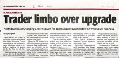 Whitehorse Historical Society Inc.
Article, North Blackburn Shopping Centre, 2017
Mr Harvey of the North Blackburn Shoe Repair is wanting to sell his business.Mr Harvey of the North Blackburn Shoe Repair is wanting to sell his business but the North Blackburn Shopping Centre will not renew his lease beyond Sep 2019 due to plans to upgrade the Centre.Mr Harvey of the North Blackburn Shoe Repair is wanting to sell his business.north blackburn square shopping centre, australian unity, north blackburn shoe repair, harvey, stewart -
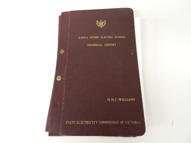 Kiewa Valley Historical Society
Book- History of SEC at Kiewa x2, Technical History of the Kiewa Hydro Scheme, circa 1960's
This book of planning and construction details covers the first detailed records the Kiewa Hydro Electricity Scheme of 1919 (ORIGINAL), 1958 (2nd Modified Plan) to the last general plan of 1961. It is an excellent overview of one of Australia's greatest construction projects (along with the Snowy River Hydro Scheme). This book highlights in detail the planning, programming and construction phases throughout the life of the construction from 1919 onwards until the 1960's. There were a few copies made using carbon paper and a type writer on foolscap paper.This book with its Parts A to D, photographs and plans/tables is very significant to the Kiewa Valley region as it details "the bones" of one of Australia's greatest construction projects that was undertaken by Governments that had the foresight and the will to undertake such a costly and environmentally imposing project for the benefit of their states and their country. This project was at a time when financial and security pressures where at a high and fluctuating level. This project was the major contributor to the expansion and diversity of non rural activities within the region. It was directly and indirectly the cause of better transportation avenues, tourism and the lifting of the regions natural facilities to sustain an ever increasing long term and short term population.This large hard (thick cover) book has both front and back sides fastened to the spine by two brass screw on pins. The book title, author/compiler and the commissioning organisation (STATE ELECTRICITY COMMISSION OF VICTORIA) together with the SEC Vic emblem are all embossed in gold script.The spine is also embossed with the title. The book contains 396 pages consisting of the 390 pages which are the duplicate(carbon copy) of the original type written pages and 6 pages of site plans. Sprinkled throughout the book are 36 original photographs of various stages of construction. There are also 17 sketches/plans scattered throughout and 22 tables.Title "KIEWA HYDRO ELECTRICITY SCHEME TECHNICAL HISTORY" author and compiler "H.H.C.WILLIAMS" below this "STATE ELECTRICITY COMMISSION OF VICTORIA"kiewa hydro electricity scheme, victorian state electricity commission, history, proposals, kiewa scheme's plans, book, h.h.c. williams -
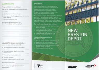 Melbourne Tram Museum
Pamphlet, Yarra Trams, "New Preston Depot", 2016
... Plans ...DL size full colour brochure / pamphlet - 3 fold - titled "New Preston Depot", produced for the open day at the former Preston workshops - gives details of the works, a site plan, safety for 17 April 2016. has the Victorian state, Yarra Trams and PTV logos. Three copies held.trams, tramways, yarra trams, plans, preston workshops, preston depot -
University of Melbourne, Burnley Campus Archives
Plan, Caroline Le Souef, Plan of the Gardens of the Zoological and Acclimatisation Society of Victoria, Royal Park, melbourne, 1877
Appears to be based on the design by Alfred Lynch in 1861 see B17.0076. From ' Little Worlds: Australian Zoological Gardens Part III UWA. Also see B18.0029 Similar plan.Copy of plan from the 'Proceedings of the Zoological and Acclimatisation Society of Victoria, Vol 4, 1877. Drawn by Caroline Le Souef and reproduced in the early Melbourne Zoo guides.caroline le souef, alfred lynch, zoological and acclimatisation society of victoria, royal park, g. purchas -
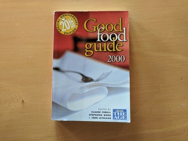 Robin Boyd Foundation
Book, Ed Claude Foreel, Stephanie Wood, John Lethlean, Good Food Guide, 2000
SoftcoverCity planning -- History, Urbanism, Urban ecologywalsh st library -
University of Melbourne, Burnley Campus Archives
Slide, Alan L. Mitchell
"Ground Plans Burnley Gardens. Research Centre."alan l. mitchell, burnley gardens, research centre -
Federation University Historical Collection
Plan, University of Ballarat Camp Street Precinct, 2000, c2000
... plans ...The university aspect of the Camp Street Precinct was named the arts AcademyFramed plans of the Univesity of Ballarat (later Federation University) Camp Street Precinct. .1) Drawing of elevations for the university of Ballarat and the City of Ballarat Camp Street Precinct elevations including a new performing arts Building, Mining Exchange, Visual Arts Building, and Alfred Deakin Place. .2) Camp Street Precinct elevations including the Ballarat Post Office, State Offices and Old Courthouse. camp street, camp street precinct, plans, daryl jackson, arts academy -
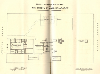 Federation University Historical Collection
Booklet, Charles Boyd, The School of Mines Ballaarat Annual Report, 1882, 1882
The School of Mines Ballaarat Annual Report 24 January 1882, Additional Examination Statute, Certificates Granted by Council, Copy of letter received from the Honble. Francis Ormond MLC, Extracts from Visitors' Book, Fees, Form of Bequest, Life Governors, Museum open to Visitors, Office Bearers, Paper of Particulars, Report of the Curator of the Museum and Library (with plans), Report of the Superintendent of Laboratories, Report of the Lecturer in Telegraphy, Report of the Lecturer in Mechanical Engineering, Statement of Receipts and Expenditure for the year 1881, Subjects and Lecturers, Subjects and Examiners, Subscriptions and Donations from 1 January to 31 December 1881, The Lignite Deposit at Skipton (with Section and Plan)Ballarat School of Mines Annual Report. Pale brown booklet of 64 pages. A plan of the Ballarat School of Mines shows the position of the Botanical Gardens, and the Ballarat School of Mines Museum. Geological Sketch Map of Country in the Neighbourhood of Skipton and Plan showing site of Coal Discovery. Skipton Coal Discovery - Section of Windlass Shaft. .2) is a leatherbound copyballarat school of mines, coal, plan, ballarat school of mines botanical gardens, ballarat school of mines museum, museum, annual report, james oddie, w. p. bechervaise, s. e. friggis, f. j. martell, w. h. nicholls,, e. i. rosenblum, h. r. caselli, thomas mann, theos. williams, f. m. krause, alf. mica smith, walter d. campbell, w. h. shaw, charles kent, andw. berry, robert adam, wm. lant carpenter, henry parkinson, h. b. de la poer wall, w. h. brockenshire, arthur parker, c. davies, simon richards, c. r. blackett, david jones, wilberforce dyke, kr. r. krauel, duncan love, william ralph heaton, edward dowling, octavius vaughan morgan, william denton, e. h. grimwade, james hunter, the honble. francis ormond, ferdinand krause, a.a. buley, j. cosmo newberry, w.c. kernot, john lewis, j.m. bickett, james bickett, fees, annie barnett, annette budden, isabel clinton, john dimsey, agnes pobjoy, charlotte shaw, bernard o'dowd, bernard patrick o'dowd, josiah wasley, ferdinand von mueller, william kernot, john lynch, william henderson, henry richards caselli, w.p. berchervaise, e.i. rosenblum, w.h. nicholls, lignate, samuel figgis, mary drury, w. longley, botanical reserve, botanical gardens, francis ormond, george russell, william foster stawell, w.j. clarke, rivett henry bland, john warrington rogers, j. lonie, s.e. figgis, r.f. hudson, w. robertson, e.l. rosenblum, theophilus williams, andrew berry, henry sutton, h. rosales, state school classes, calcutta international exhibition, examinations, h.b.m ship bounty, certicates, walter charles kernot, william tunbridge, mary skelton, cartherine moran, mary rose usher, margaret ellen brophy, william burbridge, andrea tuxen, elizabeth curnow, francis campigi, james s. morrison, arthur hogue -
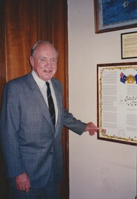 Melbourne Legacy
Photograph, President Stevenson with a diagram of Harefield Cemetery, 1993
Photo of Legatee John Stevenson, he was President in 1993. He is standing next to a mounted poster showing a plan of the graves at Harefield ANZAC Cemetery in the UK. More details of the cemetery in another record. Not sure if the poster once hung at Melbourne Legacy or if it was elsewhere. The photo was stored with other photos of an event at Northcote RSL.A photo of a past president.Photo of Legatee John Stevenson, standing next to a mounted poster showing a plan of the graves at Harefield ANZAC Cemetery in the UK.cemetery, john stevenson, harefield -
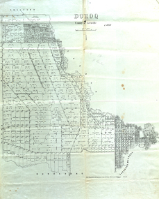 Federation University Historical Collection
Map, Doroq County of Grenville L4935, 1911, 28 June 1911
This plan is associated with former Ballarat School of Mines Student Richard Squire (1875-1876). Gift of the Squire FamilyParish Plan of Doroq in black ink printed on cream paper. It includes the township of Inverleigh and Barwon Rover. Some of the names on the plan are William McRobie, William MacRobie, Thomas Russell, W.C. Smith, John Bell, J. Moffatt, Thomas Moffatt, John Anderson, George Synnot, Charles Lloyd, William MacRobie, J. Flack, Alexander Campell, T. Maher, William Berthon. Thomas Jewell, James Carstairs, D. MCInnerney, F.H. Holland, Robert Morrison17 7/9 18 9 miles handwritten in pencil Photo lithographed at the Department of Lands and Survey Melbourne by T. E. McGauran 28.6.11 Price 1/-carrunge-murnong, murdeduke, carrah, shelford, inverleigh, barwon river, hesse, wingeel, george russell, george russell's pre-emptive section, john moffatt, w. c. smith, macrobie, john bell, thomas russell, t.f. mcgauran