Showing 706 items
matching aerial photos
-
 Ballarat Tramway Museum
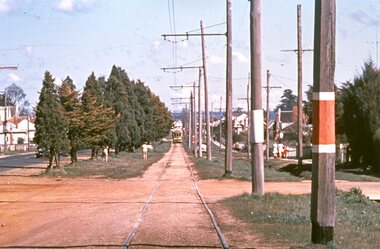
Slide - 35mm slide/s, Graham Evans, Sep. 1971
Agfa plastic mount (blue base, white cover) of a photograph of a bogie tram on the reserved track between Ophir St and the terminus - telephoto lens. Note tram stop signs, aerial phone lines, the condition of the track and the gravel crossings. Photo taken 9/1971. See also M. Plummer slides Reg. Item 2160 for similar photograph with No. 17. One of a set of 20 slides made by the Association of Railway Enthusiast Provincial Tramways film strip. Reference Item 2560 details the ARE Film Strip and provide references to other slides. Slide rescanned at 3200 dpi 25-10-2020, jpg replaced, tiff file retained. This file was scanned in 2003 and may show colour changes."BAS 70" in pencil.tramways, trams, albert st., sebastopol, ophir st -
 Ballarat Tramway Museum
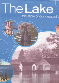
Book, The Courier Ballarat, "The Lake ... the story of our greatest treasure", 6/11/2003 12:00:00 AM
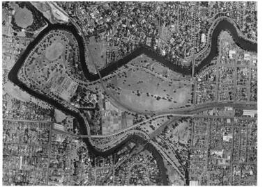
Fifty six page Newspaper supplement, titled "The Lake ... the story of our greatest treasure", published by The Courier, Ballarat, 6 November 2003. Features the history, precincts, life, flora and fauna of the Lake Wendouree and Botanical Gardens. Includes many articles, photographs of the lake, Olympic games rowing in 1956, Ballarat Tramway Museum (p31) with a photo of inside the depot, a timeline and many advertisements by local companies. The centre pages has an aerial photograph of the lake with features numbered, including the depot.trams, tramways, lake wendouree, botanical gardens, olympics, btm -
 Ballarat Tramway Museum
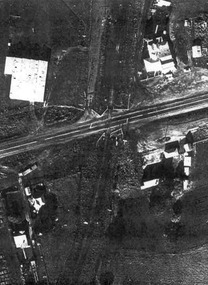
Document - Photocopies, John Phillips, Bungaree Aerial photo, 1980's
... Bungaree Aerial photo... flashing lights installed on it. Bungaree Aerial photo Document ...Demonstrates the use of bogie trams on the Lydiard St North route and the crossing of trams at Seymour St loop.Two sets of three copies of the Victorian Railways aerial photographs of Bungaree Railway station late 1960's early 1970's. Shows tennis court, station buildings, houses and sheds in the station yard. The level crossing does not appear to have any flashing lights installed on it.trams, tramways, bungaree, aerial views, victorian railways -
 Queenscliffe Maritime Museum
Print - Melbourne by Satellite by Woman's Weekly c1986, Aerial photo of Port Phillip c1986, c1986
... Aerial photo of Port Phillip c1986.... Weekly 1986, 'Melbourne by Satellite'. Aerial photo of Port ...Port PhillipAerial view of Port Phillip from 705km, 1986.Colour print insert from Woman's Weekly 1986, 'Melbourne by Satellite'.Reverse " Nil " -
 Queenscliffe Maritime Museum
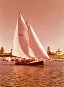
photograph - Photo of Couta boat AERIEL at Portland, AERIEL at Portland, 1986
Couta boatsGarry Kerr's Couta boat AERIAL at Portland, under sail.5 x Colour photographs of the Couta boat AERIAL, owned by Garry Kerr, at PortlandReverse - " NIL "historical references -
 Bendigo Historical Society Inc.
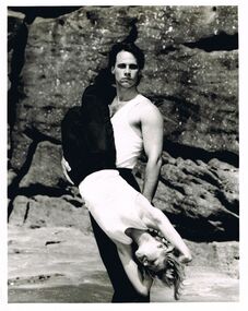
Photograph - MERLE HALL COLLECTION: PHOTOGAPHS OF PAUL MERCURIO (AND PARTNER)
a. And b. Identical B&W photgraphs of Paul Mercurio and partner (different sizes) Both with typewritten annotation ''Paul Mercurio who will be touring Victoria with his own dance company is pictured with partner Jan Pinkerton. The Australian Choreographic Ensemble have already played a successful season in Sydney and will dance in Melbourne prior to the Victorian tour''. Picture of Mercurio (standing) holding a downwards facing partner in front of rock backdrop.c.: photo of ''the lively young and exuberant dance company formed by Strictly Ballroom star Paul Mercurio limber up before a rehearsal. Annotation - ''the company are preparing to dance their way around Victoria from March 15''. Photo is of eight performers in vibrant dance poses (mostly aerial). Two advertising brochures. -
 Bendigo Historical Society Inc.
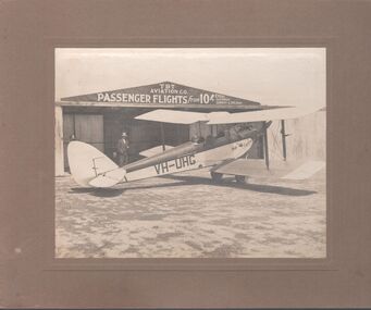
Photograph - T.B.T. Aviation Co
The Bendigo Aero Club laid out the Myers Flat aerodrome in 1929 to serve as an airport for Northern Victoria and the Riverina. In May 1929, 12 machines arrived to give an aerial display to local citizenry.Black and white photograph glued to brown cardboard. Photo of a single engine propeller plane in front of a shed. The sign on the shed reads: T.B.T. Aviation Co. Passenger flights from 10 shillings every Saturday, Sunday and Holiday. Markings on the plane: VH-UHG Eaglehawk. Two men are standing, and one is in the cockpit of the plane. Part of the Barker's family collection.At "Drome" Myers Flat. Left to right: O'Halloran, Cyril James (brother of Emmie Barker nee James), J.S. Barker.myers flat, aviation, tbt aviation -
 Bendigo Historical Society Inc.
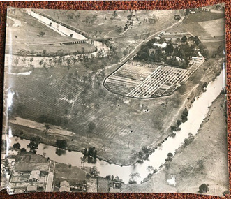
Photograph - FORTUNA COLLECTION - PHOTOGRAPH
Black and white photograph, aerial view of part of grounds showing some buildings, partial view of lake and partial view of Fortuna Villa. Writing in pen on back of photo (top left hand side) is an inscription stating 'approx 1962-3'. -
 Bendigo Historical Society Inc.
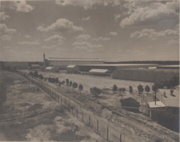
Photograph - BENDIGO ORDINANCE FACTORY COLLECTION: AERIAL VIEW OF FACTORY COMPOUND
Aerial photograph of the development of the ordinace factory , taaken in the 1950s Black & white photo, large format -
 Ballarat Tramway Museum
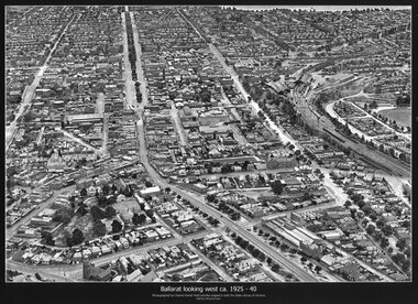
Photograph - Black & White copy, Charles Pratt, "Ballarat looking west ca 1925-40"
... Aerial Photo... St shopping centre and other places. Ballarat Aerial Photo ...Original photograph by Charles Daniel Pratt, with the original image held by the State Library of Victoria. Edited by Richard Conn. Purchased by the Museum.Provides information about the appearance of Ballarat East and views across over the Railway Station to Lake Wendouree and along along Sturt St. Shows the nature of the Bridge St shopping centre and other places.Black & White copy photograph aerial view A4 size, titled "Ballarat looking west ca 1925-40" - looking along Sturt St with the Railway yards, Bridge St and Victoria St in the view. Some trams can be seen at Grenville St.ballarat, aerial photo, sturt st, victoria st -
 Ballarat Tramway Museum
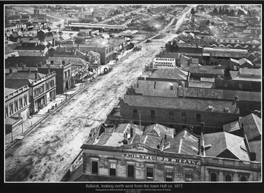
Photograph - Black & White copy, William Bardell, "Ballarat looking north west from the Town Hall ca 1872"
Original photograph by William Bardwell, with the original image held by the State Library of Victoria. Edited by Richard Conn. Purchased by the Museum.Provides information about the appearance of Armstrong St from the Town Hall. Shows the topography of the area, along with many buildings, including W Milne & Cp and J N Healy in the Hall of Commerce and Doig & Co, Plumbers and Gasfitters.Black & White copy photograph aerial view A4 size, titled ""Ballarat looking north west from the Town Hall ca 1872" looking along Armstrong St. Original photo by William Bardwell.ballarat, armstrong st, w milne & co, doig&co, j n healy -
 Ballarat Tramway Museum
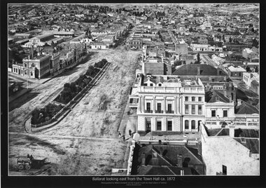
Photograph - Black & White copy, William Bardwell, "Ballarat looking east from the Town Hall ca 1872"
Original photograph by William Bardwell, with the original image held by the State Library of Victoria. Edited by Richard Conn. Purchased by the Museum.Provides information about the appearance of Sturt St Ballarat, looking from the Town Hall. Shows the topography of the area, along with many buildings, including the London Chartered Bank of Australia (later the Commonwealth Bank), the Unicorn Hotel, J. Dodds Bucks Head Hotel, road works in Bridge St, Albion House Drapery, Bryce & Chalmers Produced Merchants, a fenced central median strip and two horse-drawn carriages parked in Lydiard St.Black & White copy photograph aerial view A4 size, titled ""Ballarat looking east from the Town Hall ca 1872" looking along Sturt St towards Grenville St. Original photo by William Bardwell.ballarat, sturt st, grenville st, lydiard st, bucks head hotel, bryce & chalmers, london chartered bank, albion house, bridge st -
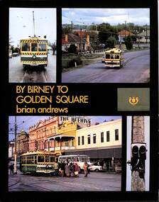 Ballarat Tramway Museum
Book, Brian Andrews, "By Birney to Golden Square", 1973
Features both black and white and colour photographs, including tickets, photos along each route, Charing Cross, depot, notes on the rolling stock with an aerial photograph of Bendigo with the tram routes marked in and a fold out detailed map of Bendigo and its track layout.Yields information about the Bendigo tramways operated by the SEC in a photographic and text format.Book, 78 pages including card cover, printed on gloss paper, titled "By Birney to Golden Square", written by Brian Andrews, published by Southern Cross Traction, Kensington Park SA. Sub-titled "The last last years of Bendigo's tramways", 1973. trams, tramways, bendigo, sec tramways, maps -
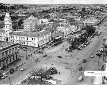 Ballarat Tramway Museum
Photograph - Illustration/s, News and Information Bureau - Photo, Ballarat view from Town Hall, Oct. 1958
Yields information about the Sturt and Lydiard St streetscape from the Town Hall, c1958.Photograph of intersection of Sturt St and Lydiard St from Town Hall. Looking north east to Black Hill. See also item with Reg. No. 667 of similar but earlier view. Photo is inside cover of ANZ quarterly survey, dated Oct. 1958. Shows four trams in City Loop and good photo of trackwork and motor cars of period. Not to be displayed - before copy neg made.Ballarat - important Provincial Citytrams, tramways, sturt st, black hill, aerial views, trackwork -
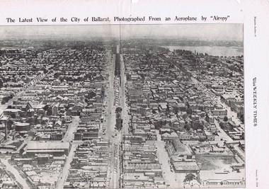 Ballarat Tramway Museum
Photograph - Illustration/s, Herald & Weekly Times Ltd, Sturt St. Aerial View, 1934, Jan. 1934
Yields information about Ballarat from the eastern aspect of the city looking west in an aerial view dated 1934. Shows buildings such as the Gas Works and other buildings that no longer exist.Photographic reproduction of Ballarat looking west down Sturt St., page 6 of Magazine section of Weekly Times, Jan 20, 1934. On rear is two colour photo of Alexandria Avenue, Melbourne. Record updated and image added 21/9/2013.trams, tramways, ballarat, sturt st., aerial views -
 Kew Historical Society Inc
Photograph - Digital Photographs [Series], Robert Baker, Exhibition: Kew From Above, Kew Court House, 2014, 2014
The Kew Historical Society, founded in 1958, is one of the oldest continuing historical societies in the Greater Melbourne region. From its beginnings, the Society has mounted exhibitions and/or displays, in early days in shop windows and in community spaces located in the Kew City Hall (later Kew Library), and since 2010 at the Kew Court House. Exhibitions typically coincided with the annual Kew Community Festival in March, but after 2013 evolved into three new exhibitions yearly at the Kew Court House. Smaller displays continue to be mounted in the Kew Library. A born digital photograph of members and guests at the exhibition opening. Photo 1: L-R Terryl de Lacey, Janet Walker, Don Garden Photo 2: Les Littlechild, Sue Littlechild, Ian Job, ..., ... Photo 3: John Torpey, Slavka Jelovac kew historical society - exhibitions, exhibition - aerial photographs - kew (vic) -
 Kew Historical Society Inc
Photograph - Kew Junction, Herald & Weekly Times, 1962
This is an aerial oblique image looking north. It shows Kew Junction before construction of VicRoads (Country Roads Board), Murphy's (Leo's) supermarket, and office towers. It also shows a building on the land now known as the Raoul Wallenberg Reserve, the Kew Municipal Offices in Walpole Street, and St Paul's School for the Blind in Fernhurst Grove, and Kew Bowling Club in Wellington Street.An aerial photograph of Kew Junction, showing the intersection of High Street South, Studley Park Road, Princess Street, High Street and Denmark Street. A number of buildings, now demolished can be identified in the photo, including Jellis’ Bakeries on the corner of Princess Street and Studley Park Road." Annotation on reverse: "Kew Historical Society from Mr L. H. Chinner".kew junction, aerial photograph (kew), oblique aerial, st paul's school for the blind, kew municipal offices, high street kew, studley park road, kew war memorial, kew post office, kew police station, kew court house, high street south, kew, wellington street kew, denmark street kew -
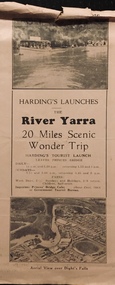 Kew Historical Society Inc
Flyer, Melbourne Ferries Pty Ltd, River Yarra: 20 Miles Scenic Wonder Trip
... 'Wonder Trip' on pages 2 & 3. Photos used include an 'Aerial view ...Bifold brochure including route map of the full 44 mile 'Wonder Trip' on pages 2 & 3. Photos used include an 'Aerial view over Dight's Falls', two ferries, and a 'Scene near Dight's Falls'.Flyer for Harding’s Launches on the River Yarra: 20 miles scenic wonder trip. Aerial view over Dight’s Falls on front. non-fictionBifold brochure including route map of the full 44 mile 'Wonder Trip' on pages 2 & 3. Photos used include an 'Aerial view over Dight's Falls', two ferries, and a 'Scene near Dight's Falls'.river yarra, melbourne ferries pty ltd, yarra river -- tourism, harding's cruises, christian-washfold collection -
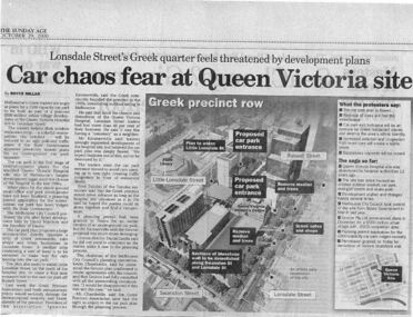 Queen Victoria Women's Centre
Newspaper excerpt, The Sunday Age, Car Chaos fear at Queen Victoria Site: Lonsdale Street's Greek quarter feels threatened by development plans, 29 October 2000
Newspaper excerpt from The Sunday Age. Page 5 and a smaller introduction probably from the front page. Smaller excerpt colour photo of blue-stone and cast-iron wall which was to be demolished. Larger excerpt, a black and white aerial view of QVWC and the block where it is situated. building construction, building permits, historic building -
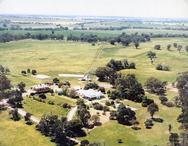 Stawell Historical Society Inc
Photograph, "Kirkella" Homestead 2001 -- Aerial Photo
... "Kirkella" Homestead 2001 -- Aerial Photo... -- Aerial Photo Photograph ...Aerial photograph of Kirkella homestead taken in 2001. Shows Cricket pitch on Right Hand Side of photo partly surrounded by trees.stawell sport -
 Stawell Historical Society Inc
Photograph, Stawell Aerial View from a Souvenir photo from the Melbourne Argus Newspaper 1936
... Aerial View from a Souvenir photo from the Melbourne Argus ...Aerial Views of Stawell 1933. Argus newspaper. Looking West along Main Street in centre of photo.stawell -
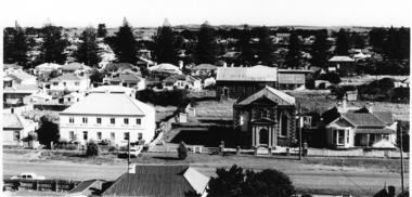 Port Fairy Historical Society Museum and Archives
Photograph
Views from St Johns 1973Black and white photograph aerial view of Braim House Methodist Church and it's Manse with Sunday school in backgroundphoto, st johns, tower, james street, aerial, methodist, weslyian, braim house -
University of Melbourne, Burnley Campus Archives
Map, Photo Mapping Services Pty. Ltd, Burnley College Burnley Gardens, 1995
HistoricalMap compiled by Photo Mapping Services Pty. Ltd., using aerial photography, dated 9th July, 1995. (1) Coloured proof. Scale 1:500. Aerial views, with and without trees marked, of Burnley Gardens: (2) Map with trees (3) Map without trees, sections numbered but no legend.burnley college, gardens, trees -
 University of Melbourne, Burnley Campus Archives
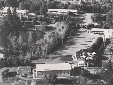
Photograph - Black and white prints, Aerial View of Burnley Campus, 1963-1970
Freeway was not begun until 1968.Black and white photographs. Aerial View of Burnley Campus. (B) Original of (A). Enlargement (C) Laminated copy(A) Inscribed on reverse, "South Eastern Freeway 9.7.63 R22.024.439." (C) Paper attachment: The Burnley College Portion of Richmond Park in 1972. Swan Street Takes Its Familiar Route. The Boulevard Has Been Constructed. The Golf Course is in Place. The Series of Parallel Buildings Along the Railway Line at the Bottom of the Photo Are the Poultry Sheds Used For Egg-Laying Competitions. Burnley Sidings Were Still to be Built. In the Mid-1990's Much of the Western Portion of the College Grounds/Richmond Park Was Sold.burnley campus, aerial view, south eastern freeway, richmond park, swan street, yarra boulevard, richmond golf course, poultry sheds -
 University of Melbourne, Burnley Campus Archives
Photograph - Black and white print, Airspy, Aerial View of Burnley Campus c. 1925, c. 1925
TH Kneen and EB Littlejohn note that the Principal's House has been extended. This was done for J P McLennan, Principal 1917-1921. Note "Bird Cage" in Orchard, dwarf fruit trees, shed where tobacco was stored. Photo taken before Plant Research Institute was built in 1929. Photo shows there had been cultivation outside the College grounds, beyond the orchard area and hedge.Colour photograph of black and white photograph. Aerial view of Burnley Campus. Cultivation outside Burnley Campus burnley campus, principal's house, jp mclennan, bird cage, orchard, dwarf fruit trees, plant research institute, principal's residence, tobacco storage sheds, cultivation outside campus -
University of Melbourne, Burnley Campus Archives
Plan - Plan, aerial photograph, Works Plan Scale 1:2000 [Aerial photograph of quarry]
... of photograph: Lilydale Quarry Grid & a photo Plan and aerial photograph ...In pencil on back of photograph: Lilydale Quarry Grid & a photolilydale, quarry -
 Friends of Ballarat Botanical Gardens History Group
Work on paper - Adam Lindsay Gordon, Australian Poet, Souvenir from Adam Lindsay Gordon's Cottage, Unknown
This leaflet gives a chronology of Gordon's life and a photograph of him. And printed on the other side, besides the aerial view of the cottage is a paragraph about the two years he spent in the cottage, 1867-1868 three short extracts of his poetry.Documents available and newspaper extracts make it clear that some Ballarat Citizens were proud of their city's association with this poet. 1 yellow leaflet printed on both sides in blue, with a photo of Gordon on the right side of p.1 and an aerial view of the Cottage off-centre on p.2. Originally folded twice.Noneadam lindsay gordon, adam lindsay gordon cottage, john garner, doctor, ballarat botanic gardens, craig's hotel, australian poet, friends of ballarat botanical gardens, john garner collection, poet, gardens, ballarat -
 Wodonga & District Historical Society Inc
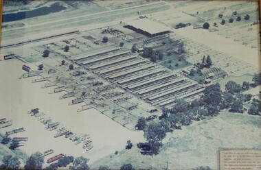
Photograph - W. G. Page Saleyards, Wodonga, c1980
William George Page was Shire and City Engineer in Wodonga from 1965 until 1989. When he arrived the Shire of Wodonga had a population of 17,000 people. In 1966 Wodonga was selected as a city for special growth assistance. In 1972 Bill Page presented a new Town Plan to the Wodonga Council. Over the ensuing years he dedicated himself to bring this plan to fruition. He often had to argue and campaign with the Albury-Wodonga Corporation to push for the interests of development in Wodonga. This included winning a planning appeal to allow the saleyards to be relocated to Bandiana on the outskirts of Wodonga. Bill Page retired on health grounds in July 1989. The Council honoured him with a farewell dinner and renamed the saleyards at Bandiana the W.G. Page Saleyards in his honour.The Mayor , Cr Valentina Gillard, said "Every development in Wodonga in the past 24 years has a bit of Bill Page in it". William Page died 3 months later at 58 years old.This image depicts an important centre in the development and support of the livestock industry around Wodonga.An aerial photograph of the W. G. Page Saleyards in Wodonga. It has been mounted in a wooden frame.On a sign attached to the photo frame: "This photo of the W.G. Page Saleyards has been donated to the people of Wodonga from Mrs Pat Page and Family. The saleyards were named after the late Bill Page, City Engineer of Wodonga Council for 25 years until his death".w. g. page saleyards, wodonga saleyards, william george page -
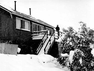 Falls Creek Historical Society
Photograph - Thea Hedley at Bowna Ski Club, 20 September 1959
This photo is part of the Fred Griffith Photographic Collection. Frederick Charles “Fred” Griffith was born in Albury, NSW on 2 March 1910. Educated in Albury and Geelong Grammar. Beginning in 1927 he spent many years working first as a jackeroo and on a range of prominent pastoral and merino stud properties in NSW and Queensland. In 1935 he repurchased his former family property “Toonallook", Bowna, NSW and developed it to be the largest Romney Marsh stud in the world, exporting rams to Argentina. He introduced many innovative practices on his property including rabbit control measures and aerial crop dusting. He was an active member of the Albury Show Society and in 1949 established the Albury Sheep Show. Fred was also the Albury representative on the Graziers’ Association Council for over 30 years. He became a life member of both the Albury and Commercial Clubs. Fred’s greatest hobby was snow skiing. His first visit to the snow was to Kosciusko in 1919. The Albury Ski Club was formed in 1935 and Fred was an inaugural member. In 1949 they were granted a site at Falls Creek to build their own lodge. Fred guaranteed the Club for finance from the Bank of NSW. The first portion of the prefabricated building was constructed in Albury. It was transported to Falls Creek on the back of Fred’s truck and erected in one day. This was the bathroom section and the rest was completed in 1950. The original lodge was burned down in 1952 and a new one built the following year. In 1955, Fred also built the Bowna Lodge for his family in partnership with David Fairbairn. He became head of the North Eastern District Skiing Association (N.E.D.S.A.) and successfully applied to run the Australian Ski Championships. Fred also inaugurated children’s races at Falls Creek and ran them for about 20 years. He also formed the company “Falls Creek Ski Tows”. In 1956 Fred along with a group of key people selected the site for Thredbo Village. Fred and his brother sold Toonallook in sections between 1951 and 1974. He moved to Albury and set up as a landscape gardener and fencing contractor. After a serious work accident, Fred retired in 1985 and moved to Rosebud, Victoria where he died on 19 August 1992. Bowna is now known as the Riverina Ski Club.This image depicts Fred Griffith who was a pioneer of the Albury Ski Club and Falls Creek4 black and white photo showing Thea Hedley at various parts of Bowna Ski Club at Falls Creekfred griffith, albury ski club, falls creek, bowna ski club -
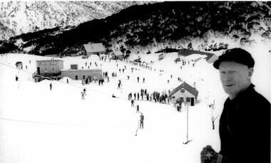 Falls Creek Historical Society
Photograph - Sandy McNabb at Bowna Ski Club
This photo is part of the Fred Griffith Photographic Collection. Frederick Charles “Fred” Griffith was born in Albury, NSW on 2 March 1910. Educated in Albury and Geelong Grammar. Beginning in 1927 he spent many years working first as a jackeroo and on a range of prominent pastoral and merino stud properties in NSW and Queensland. In 1935 he repurchased his former family property “Toonallook", Bowna, NSW and developed it to be the largest Romney Marsh stud in the world, exporting rams to Argentina. He introduced many innovative practices on his property including rabbit control measures and aerial crop dusting. He was an active member of the Albury Show Society and in 1949 established the Albury Sheep Show. Fred was also the Albury representative on the Graziers’ Association Council for over 30 years. He became a life member of both the Albury and Commercial Clubs. Fred’s greatest hobby was snow skiing. His first visit to the snow was to Kosciusko in 1919. The Albury Ski Club was formed in 1935 and Fred was an inaugural member. In 1949 they were granted a site at Falls Creek to build their own lodge. Fred guaranteed the Club for finance from the Bank of NSW. The first portion of the prefabricated building was constructed in Albury. It was transported to Falls Creek on the back of Fred’s truck and erected in one day. This was the bathroom section and the rest was completed in 1950. The original lodge was burned down in 1952 and a new one built the following year. In 1955, Fred also built the Bowna Lodge for his family in partnership with David Fairbairn. He became head of the North Eastern District Skiing Association (N.E.D.S.A.) and successfully applied to run the Australian Ski Championships. Fred also inaugurated children’s races at Falls Creek and ran them for about 20 years. He also formed the company “Falls Creek Ski Tows”. In 1956 Fred along with a group of key people selected the site for Thredbo Village. Fred and his brother sold Toonallook in sections between 1951 and 1974. He moved to Albury and set up as a landscape gardener and fencing contractor. After a serious work accident, Fred retired in 1985 and moved to Rosebud, Victoria where he died on 19 August 1992.This image depicts early visitors to the Albury Ski Club and Falls Creek.A black and white photo of Sandy McNabb overlooking Falls Creek ski slope and skiers below.fred griffith, albury ski club, falls creek, bowna ski club