Showing 1425 items matching "allotment"
-
 Bendigo Historical Society Inc.
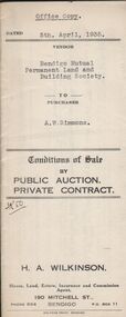
Document - H.A. & S.R. WILKINSON COLLECTION: CONTRACT OF SALE
Conditions of sale by private contract dated 5th April, 1935 between Bendigo Mutual Permanent Land and Building Society (seller) and A.W. Simmons (buyer) for land being Crown allotment 7 section 104C and being the whole land described in certificate of title volume 2684 folio 536778. Price 450 pounds.organization, business, h.a. & s.r wilkinson real estate -
 Ringwood and District Historical Society
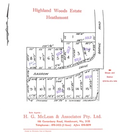
Document, Subdivision Plan - Highland Woods Estate, Heathmont, Victoria (undated, circa 1968)
Map of 15 residential allotments for sale, with seven rubber-stamped SOLD and one with handwritten notation "$5650 1968". Subdivision includes Barrow Drive and Barnic Road, Heathmont. Agent - H.G. McLean & Associates Pty. Ltd., 166 Canterbury Road, Heathmont Vic., 3135, Telephones : 870-3422 A/hrs 870-5879. -
 Bendigo Historical Society Inc.
Document - LANDS OFFICE - PLANS FORWARDED TO CROWN LANDS OFFICE, 1.9.1871 to 5.4.1880
Document: hard cover journal, brown cover with darker tan spine. 239 pages. Contains index at front of journal. Listings of plans forwarded to Melbourne Crown Lands Office by Bendigo Office. Alphabetical listing in front followed by numbered pages with individual details. Parish, county, allotment, section, surveyor, date remarks.Lands Officelands office, sandhurst, bendigo, land sales, land surveyed, plans -
![Plan, Improvements on the Camp Reserve Ballarat, 1870, 26/4/1870 (exact); Traced by Henry [Mornes?], district surveyor, on the above date](/media/collectors/4f729f6797f83e0308601707/items/4f72a4fa97f83e0308602508/item-media/59b79d3921ea680200c6b8a7/item-fit-380x285.jpg) Federation University Historical Collection
Federation University Historical CollectionPlan, Improvements on the Camp Reserve Ballarat, 1870, 26/4/1870 (exact); Traced by Henry [Mornes?], district surveyor, on the above date
The Ballarat Camp housed the Goldfields administrators. It was from this site that the troopers left on the morning of 3 December 1854 to attack the Eureka Stockade. Much of the area shown in on the west side of Camp Street is now used by the Federation University Arts Academy.Hand-drawn plan on white linen showing the camp reserve in what is now known Ballarat's Camp Street. The plan shows allotments in an area bounded by Mair, Sturt and Lydiard Streets. The plan has colours indicating wooden buildings, stone buildings, brick buildings, Wood & zinc buildings, and wood & brick buildings.ballarat, camp street, horace walker, henry mornes, goldfields architecture, reserve for public, buildings, goldfields administration, eureka stockade -
 The Beechworth Burke Museum Research Collection
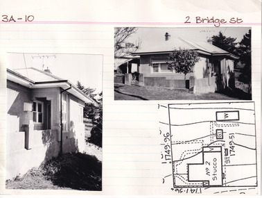
Card (Series) - Index Card, George Tibbits, 2 Bridge Street, Beechworth, 1976
George Tibbits, University of Melbourne. Faculty of Architecture, Building and Town & Regional PlanningIndex system that support the research for Beechworth : historical reconstruction / [by] George Tibbits ... [et al]Arranged by street names of BeechworthEach index card includes: street name and number of property, image of property, allotment and section number, property owners and dates of ownership, description of the property according to rate records, property floor plan with dimensions.beechworth, george tibbitsbeechworth, george tibbits -
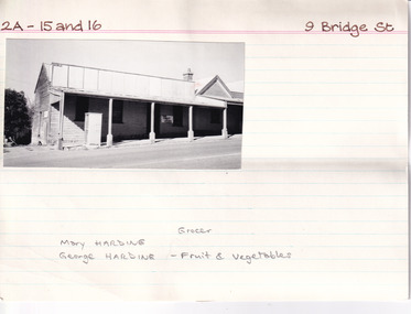 The Beechworth Burke Museum Research Collection
Card (Series) - Index Card, George Tibbits, 9 Bridge Street, Beechworth, 1976
George Tibbits, University of Melbourne. Faculty of Architecture, Building and Town & Regional PlanningIndex system that support the research for Beechworth : historical reconstruction / [by] George Tibbits ... [et al]Arranged by street names of BeechworthEach index card includes: street name and number of property, image of property, allotment and section number, property owners and dates of ownership, description of the property according to rate records, property floor plan with dimensions.beechworth, george tibbitsbeechworth, george tibbits -
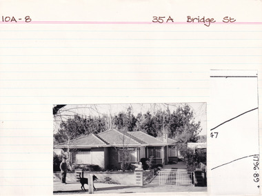 The Beechworth Burke Museum Research Collection
Card (Series) - Index Card, George Tibbits, 35A Bridge Street, Beechworth, 1976
George Tibbits, University of Melbourne. Faculty of Architecture, Building and Town & Regional PlanningIndex system that support the research for Beechworth : historical reconstruction / [by] George Tibbits ... [et al]Arranged by street names of BeechworthEach index card includes: street name and number of property, image of property, allotment and section number, property owners and dates of ownership, description of the property according to rate records, property floor plan with dimensions.beechworth, george tibbitsbeechworth, george tibbits -
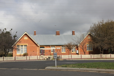 Ballarat Heritage Services
Photograph - Photograph - Colour, L.J. Gervasoni, Carisbrook Primary School no. 1030, 06/08/2011
Carisbrook State School No 1030 was firsy opened on 01 July 1855 as the non=vested Church of England School No 130., becoming a Cmmon School in 1869. A new site was sought, and a two acre corner allotment was selected, being excised from the Police Reserve in October 1873 in Victoria Street.Brick school building at Carisbrook, Victoria. carisbrook, carisbrook primary school, education, carisbrook state school -
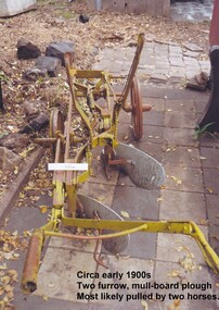 City of Moorabbin Historical Society (Operating the Box Cottage Museum)
Tool - Farm Machinery, Horse-drawn Furrow Plough, Early 20th Century
Late 1800s-early 1900s A horse-drawn furrow plough is an example of the type of farm implement widely used by pioneer market gardeners in the Moorabbin Shire following 'Dendy's Special Survey' of 1841 and the Crown Land Sale in 1852. Land allotments were bought by pioneer settlers who established or rented allotments for market gardens in the area. They supplied produce to the markets in St Kilda and Melbourne. During the gold-rush of the 1850s the rapidly increasing population of Melbourne saw a huge demand and a rise in prices for all foodstuffs, including the vegetables and fruit grown in the Shire of Moorabbin. This heralded a time of prosperity for market gardeners, and an equally rapid expansion of the numbers of vegetable and produce growers in the area. The 'knock-on effect" resulted in an increased interest and development of the community in the Shire of Moorabbin.Following 'Dendy's Special Survey' of 1841 and the Crown Land Sale in 1852, land allotments were bought by pioneer settlers who established or rented allotments for market gardens in the area and they supplied produce to the markets in St Kilda and Melbourne. During the gold-rush of the 1850s the rapidly increasing population of Melbourne saw a huge demand and a rise in prices for all foodstuffs, including the vegetables and fruit grown in the Shire of Moorabbin. Circa late 1800's to early 1900s. A horse-drawn furrow plough was the most common type of agricultural implement used by the pioneers of the 1800s and continued on into the 1940s when motorised tractors came into use. This plough is an example of a two furrow, mullboard plough which would most likely have been pulled by two horses. The long handle was used to lower the silver plates, (mullboards), to the chosen depth of soil. Painted yellow. Although this Box Cottage museum plough is unbranded, the most widely used plough in the Shire of Moorabbin was made by Oliver. This plough appears to be identical to that brand. brighton, moorabbin, pioneers, fruit, bentleigh, vineyards, vegetables, plough, market gardens, plow -
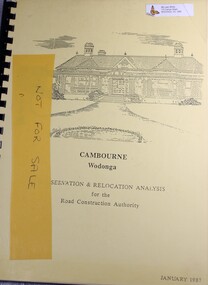 Wodonga & District Historical Society Inc
Booklet - Cambourne Wodonga : Conservation & Relocation Analysis for the Road Construction Authority, John & Thurley O'Conner, 1987
Research paper into the viability of relocating Cambourne Homestead in 2006 in order to make way for the widening and upgrade of the Hume Highway.non-fictionResearch paper into the viability of relocating Cambourne Homestead in 2006 in order to make way for the widening and upgrade of the Hume Highway. cambourne homestead wodonga, heritage building wodonga, carkeek family, potter family, building relocation -
 Ringwood and District Historical Society
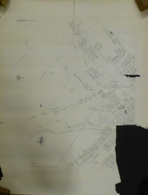
Map, Proposed Subdivision - Hilltop Estate, Heathmont, Victoria - circa 1925
Plan of Part of Crown Allotments 16 & 18, Parish of Ringwood, County of Mornington. Subdivision includes Site for Heathmont Station, Heathmont Road, George Street, Lilian Street, Edith Street, Edna Street, Great Ryrie Street. Inset locality plan also shows nearby Electric Railway Estate and Heathmont Station Estate. L.H. Webber, Licensed Surveyor, 440 Little Collins Street, Melbourne. -
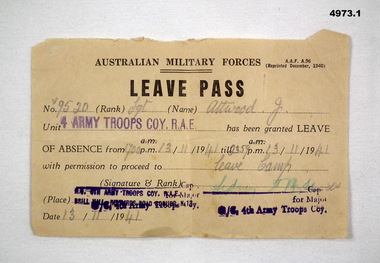 Bendigo Military Museum
Document - ARMY DOCUMENTS, Australian Army, 1. Leave Pass, 2. Pay Allotments sheet, 1. 1940. 2. 1941
See cat 4967.21. AMF Form AAF A96- Aust Military Force Leave pad - issued to V9520. Sgt Attwood J - 4 Army Troops Coy. RAE 13 Nov 1941. 2, AMF Form WF66 Military allotments - pay form V9520 Attwood J to Mrs Mary A Attwood of Bacchus Marsh Dated 15.10.43.2. Rubber stamp has "Checking staff 3rd M.D." 26 stamped 18 Oct 43.ww2, leave, pay -
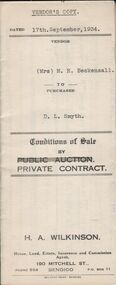 Bendigo Historical Society Inc.
Document - H.A. & S.R. WILKINSON COLLECTION: CONTRACT OF SALE
Conditions of sale by private contract dated 17th September, 1934 between Mrs. M.H. Beckensall (seller) and D.L. Smyth for land situate corner McIvor Road and Donovan, Bendigo being Crown allotment 1 section 93C described in Crown grant volume 265 folio 52937. Price 200 pounds. Vendor's copy.organization, business, h.a. & s.r wilkinson real estate -
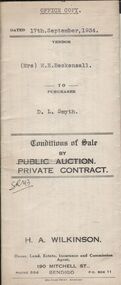 Bendigo Historical Society Inc.
Document - H.A. & S.R. WILKINSON COLLECTION: CONTRACT OF SALE
Conditions of sale by private contract dated 17th September, 1934 between Mrs. M.H. Beckensall (seller) and D.L. Smyth for land situate corner McIvor Road and Donovan, Bendigo being Crown allotment 1 section 93C described in Crown grant volume 265 folio 52937. Price 200 pounds. Office copy.organization, business, h.a. & s.r wilkinson real estate -
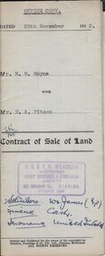 Bendigo Historical Society Inc.
Document - H.A. & S.R. WILKINSON COLLECTION: CONDITION OF SALE
Contract of sale of land dated 28th November, 1952 between Mrs. M.M. Goyne (seller) and Mr. H.A. Pitson (buyer) for land situate No. 140 Lily Street, Bendigo being allotment 21 section 39B described in right to occupy residence area No. 4775, together with weatherboard dwelling and all sundry. Price 1,075 pounds.organization, business, h.a. & s.r wilkinson real estate -
 Bendigo Historical Society Inc.
Document - TITLE OF LAND AXEDALE
Land title Vol. 3730 Fol. 745810. On the fifth of April Edward Patrick Drake of Axedale hotelkeeper paid 6 pounds for one acre more of less being allotment four of section seven in the town of Axedale, parish of Axedale County. On the other side the names and dates of when the land changed hands up to July 1976.axedale, history, drake family -
 Bendigo Historical Society Inc.
Document - MCCOLL, RANKIN AND STANISTREET COLLECTION: NEW DON NO LIABILITY LEDGER
Document: McColl, Rankin & Stanistreet, New Don ledger. Green cover with red binding. Ledger detailing expenses of the New Don No Liability, mostly done fortnightly. Details fees paid out for travelling expenses, allotments, legal charges, advertising with either vouchers given ( noted in ledger ) or signatures showing amount owed/received.McColl, Rankin & Stanistreetorganization, business, new don no liability, mccoll, rankin & stanistreet , new don no liability, gold, goldmining, bendigo -
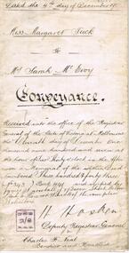 Bendigo Historical Society Inc.
Document - JOHANSON COLLECTION: CONVEYANCE TUCK TO MCEVOY
Legal document, heavy parchment, handwritten in black ink. On front ' dated the 4th day of December 1907, Miss Margaret Tuck to Mrs Sarah McEvoy, Conveyance. Document deals with the transfer of property allotment number 7 of section 12 township of Heathcote, on the death of Margaret Tuck, spinster, formerly of Heathcote. Accession number 454/17business, legal, horwood hincott -
 Bendigo Historical Society Inc.
Document - LANDS OFFICE - SALE OF CROWN LANDS - 1864 - 1869, 1864- 1869
Journal: LANDS OFFICE - SALE OF CROWN LANDS - 1864 - 1869 Brown hard cover journal. Contains details of sales of crown land, listed in chronological order of sales. Includes lot, allotment, section, county, parish, area, upset price per acre, deposit, amount for which sold, valuation, name of purchaser. On spine 011Lands Officelands office, crown land, crown land sales, land sales, bendigo, sandhurst -
 Bendigo Historical Society Inc.
Administrative record - LANDS OFFICE: APPLICATIONS FOR ALLOTMENTS FOR SALE 1869 - 1877, 1869 - 1877
Ledger. Hard cover journal, green cover with dark red spine and corners. Approx. 500 pages. LH page: date, parish, sec. allot. Area, applicant, address, valuation. RH page: owner of improvements, any other improvement on lot, upset price, remarks. On spine - 'applications for allotments for sale' and 'appn's for sale'.Lands Officeplace, land sales, bendigo, sandhurst -
 Bendigo Historical Society Inc.
Document - REGISTRATION OF RESIDENCE AREAS 9433 - 13296: 1899 - 1905, 1899 - 1905
Document: hard cover journal, originally dark cover with burgundy binding on spine. In very poor condition, pages loose. Details: left hand page: date of registration, holder or owner, miners right etc., description of allotment, township or parish, memo, registration. Right hand page: same. Details land registrations in Bendigo and district.bendigo, sandhurst, land sales, residence licences -
 Bendigo Historical Society Inc.
Document - MARKS COLLECTION: PLAN OF SANDHURST CITY CENTRE AND SURROUNDING AREA ( NO. 2 )
Plan drawn on heavy parchment. Written on plan Sandhurst Sheet No. 2. (See record 8300.58 for continuation of plan into city centre) Plan shows allotments with owner names, where applicable. Quartz crushing machines marked. On bottom lithographed at the Department of Lands and Survey, Melbourne, by D. Henerson, March 12th., 1867. There is also a photocopy.bendigo, planning, sandhurst -
 Glen Eira Historical Society
Document - Helenslea, Shelford CEGGS
Three copies of a photocopied fold out brochure for the auction of Helenslea mansion and stables on 25/03/1916 in association with the sale of the adjoining allotments of the Helenslea Estate. The brochure includes a map of the Helenslea Estate, a photograph of the view from Helenslea Mansion, an illustration of the exterior of the Mansion and a detailed floor plan of the Mansion and stables.helenslea mansion, helenslea estate plan, glen eira road, hood crescent, merton street, stables, hawthorn road, orrong road, morrice street, helenslea road, st kilda east, auctions, st mary’s church, caulfield north, land subdivision, land brochures, residential development -
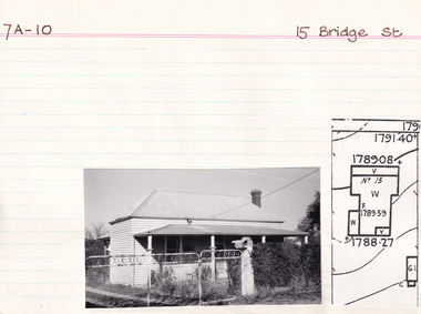 The Beechworth Burke Museum Research Collection
Card (Series) - Index Card, George Tibbits, 15 Bridge Street, Beechworth, 1976
George Tibbits, University of Melbourne. Faculty of Architecture, Building and Town & Regional PlanningIndex system that support the research for Beechworth : historical reconstruction / [by] George Tibbits ... [et al]Arranged by street names of BeechworthEach index card includes: street name and number of property, image of property, allotment and section number, property owners and dates of ownership, description of the property according to rate records, property floor plan with dimensions.beechworth, george tibbitsbeechworth, george tibbits -
 Warrnambool and District Historical Society Inc.
Legal record - Warrnambool City Council
These items are original records from the Warrnambool City Council and contain information on land sales and sub-divisions within the city area for the second half of the 20th century. The ledger contains the names of those involved in the sale and transfer of land and the file cards give illustrative details of the allotments – plans, maps etc. These items are of considerable significance as they are Warrnambool City Council records dealing with land sales and sub-divisions in the second half of the 20th century. They will be useful for research. .1 A metal-bound ledger with a dark red leather cover and pages printed with red and blue lines. There are red alphabetical tabs with gold print attached to the outer edges of the pages. The entries are handwritten in blue ink. .2 A grey metal cabinet, rectangular in shape and rusted on the base. The cabinet has two drawers with handles and these drawers contain file cards. The cards have a negative or transparency inserted into the top corner. .3 File cards with a negative inserted and a green backing .4 File cards similar to .3 above but of a different size. .5 A packet of unused file cards with tabs land sales and sub-divisions, warrnambool city council -
Clunes Museum
Certificate - CERTIFICATE OF TITLE, 1884
CERTIFICATE OF TITLE. UNDER THE TRANSFER LAND STATUTE CATHERINE GRETTON OF CLUNES PROPRIETOR OF SAID CROWN ALLOTMENT WILLED TO JOHN LUCAS AND WILLIAM GRETTON DATED 28TH JUNE 1899. CATHERINE WOOLCOCK OF CLUNES INHERITED PROPERTY FROM JOHN LUCAS AND WILLIAM GRETTON JUNE 28TH 1899 AT 3 O'CLOCK IN THE AFTERNOON.PHOTOSTAT COPY, VICTORIAN GOVERNMENT CERTIFICATE OF TITLE. CATHERINE GRETTON OF CLUNES. DATED 14TH DAY OF MAY 1884.local history, document, certificates, document - title -
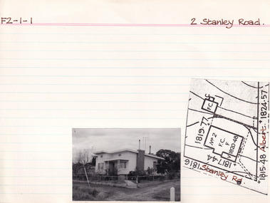 The Beechworth Burke Museum Research Collection
Card (Series) - Index Card, George Tibbits, 2 Stanley Road Beechworth, 1976
George Tibbits, University of Melbourne. Faculty of Architecture, Building and Town & Regional PlanningIndex system that support the research for Beechworth : historical reconstruction / [by] George Tibbits ... [et al]Arranged by street names of BeechworthEach index card includes: street name and number of property, image of property, allotment and section number, property owners and dates of ownership, description of the property according to rate records, property floor plan with dimensions.beechworth, george tibbitsbeechworth, george tibbits -
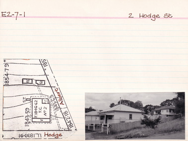 The Beechworth Burke Museum Research Collection
Card (Series) - Index Card, George Tibbits, 2 Hodge Street (Cnr Albert Rd & Upper Stanley Rd), Beechworth, 1976
George Tibbits, University of Melbourne. Faculty of Architecture, Building and Town & Regional PlanningIndex system that support the research for Beechworth : historical reconstruction / [by] George Tibbits ... [et al]Arranged by street names of BeechworthEach index card includes: street name and number of property, image of property, allotment and section number, property owners and dates of ownership, description of the property according to rate records, property floor plan with dimensions.beechworth, george tibbitsbeechworth, george tibbits -
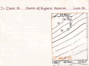 The Beechworth Burke Museum Research Collection
Card (Series) - Index Card, George Tibbits, Loch Street, Beechworth, 1976
George Tibbits, University of Melbourne. Faculty of Architecture, Building and Town & Regional PlanningIndex system that support the research for Beechworth : historical reconstruction / [by] George Tibbits ... [et al]Arranged by street names of BeechworthEach index card includes: street name and number of property, image of property, allotment and section number, property owners and dates of ownership, description of the property according to rate records, property floor plan with dimensions.beechworth, george tibbitsbeechworth, george tibbits -
 The Beechworth Burke Museum Research Collection
Card (Series) - Index Card, George Tibbits, Ford Street, Beechworth, 1976
George Tibbits, University of Melbourne. Faculty of Architecture, Building and Town & Regional PlanningIndex system that support the research for Beechworth : historical reconstruction / [by] George Tibbits ... [et al]Arranged by street names of BeechworthEach index card includes: street name and number of property, image of property, allotment and section number, property owners and dates of ownership, description of the property according to rate records, property floor plan with dimensions.beechworth, george tibbitsbeechworth, george tibbits