Showing 1795 items matching "bushfires or Black Saturday or wildfire or Ash Wednesday fires"
-
 Marysville & District Historical Society
Photograph (item) - Colour photograph, Unknown
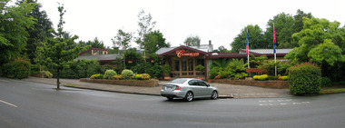
... 2009 black saturday bushfires... accommodation 2009 black saturday bushfires villa day spa photograph ...A digital copy of a colour photograph of the front entrance at The Cumberland guest house in Marysville.A digital copy of a colour photograph of the front entrance at The Cumberland guest house in Marysville.marysville, victoria, australia, the cumberland guest house, accommodation, 2009 black saturday bushfires, villa day spa, photograph -
 Marysville & District Historical Society
Ephemera (item) - Envelope, Unknown
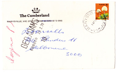
... 2009 black saturday bushfires... accommodation 2009 black saturday bushfires villa day spa envelope GEO ...An envelope from The Cumberland guest house in Marysville. The envelope was sent to Tattersalls in Melbourne on 14th February 1978.An envelope from The Cumberland guest house in Marysville. The envelope was sent to Tattersalls in Melbourne on 14th February 1978.GEO ADAMS/ 000000 20.2.78 Cuzens P MARYSVILLE-VIC-AUST/ 14FE78marysville, victoria, australia, the cumberland guest house, accommodation, 2009 black saturday bushfires, villa day spa, envelope -
 Marysville & District Historical Society
Photograph (item) - Colour photographs, Daryl Hull, Unknown
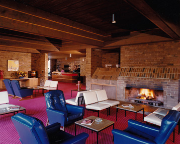
... 2009 black saturday bushfires... accommodation 2009 black saturday bushfires villa day spa photograph ...A series of twelve photographs taken at The Cumberland guest house in Marysville. The photographs are of both the interior and exterior areas at the guest house.A series of twelve photographs taken at The Cumberland guest house in Marysville. The photographs are of both the interior and exterior areas at the guest house.marysville, victoria, australia, the cumberland guest house, accommodation, 2009 black saturday bushfires, villa day spa, photograph -
 Marysville & District Historical Society
Ephemera (item) - Notepad, THE CUMBERLAND MARYSVILLE & villa day spa, Unknown
... 2009 black saturday bushfires... accommodation notepad 2009 black saturday bushfires villa day spa ...A notepad from The Cumberland guest house in Marysville. The notepad was produced for the use of guests staying at the guest house.A notepad from The Cumberland guest house in Marysville. The notepad was produced for the use of guests staying at the guest house.marysville, victoria, australia, the cumberland guest house, accommodation, notepad, 2009 black saturday bushfires, villa day spa -
 Greensborough Historical Society
Slide - Photograph, John Ramsdale, Post bushfire regrowth, Upper Plenty: Slide 31, 1990s
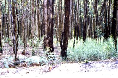
... bushfires...bushfires ...Photograph shows a bush scene with trees that are regenerating after a bushfire in the Upper Plenty area.Part of the John Ramsdale collection of slides and audio visual material.Colour photograph scanned from slide.No maker's marks. Caption on slide "T & Bs"bushfires, upper plenty, vegetation -
 Marysville & District Historical Society
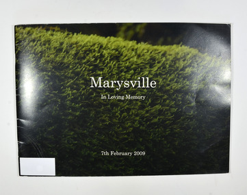
Book, Julia Peddie, Marysville-In Loving Memory, 2009
... the 2009 Black Saturday bush fire.... of photographs taken in and around Marysville before the 2009 Black ...A book of photographs taken in and around Marysville before the 2009 Black Saturday bush fire.Front cover has a photograph of what appears to be a hedge. Back cover has a photograph of Steavensons Falls.non-fictionA book of photographs taken in and around Marysville before the 2009 Black Saturday bush fire.marysville, victoria, history -
 Marysville & District Historical Society
Book, Julia Peddie, Marysville-In Loving Memory, 2009
... the 2009 Black Saturday bush fire.... of photographs taken in and around Marysville before the 2009 Black ...A book of photographs taken in and around Marysville before the 2009 Black Saturday bush fire.Front cover has a photograph of what appears to be a hedge. Back cover has a photograph of Steavensons Falls.non-fictionA book of photographs taken in and around Marysville before the 2009 Black Saturday bush fire.marysville, victoria, history -
 Eltham District Historical Society Inc
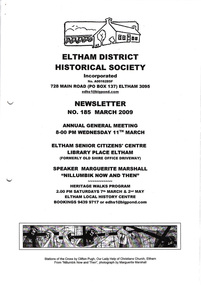
Newsletter, Newsletter, No. 185 March 2009
... • Nillumbik Now and Then • ‘Black Saturday’ Bushfires • Celebrating... • Nillumbik Now and Then • ‘Black Saturday’ Bushfires • Celebrating ...Contents: • Next meeting, guest speaker; Marguerite Marshall: Nillumbik Now and Then • Annual General Meeting • Nillumbik Now and Then • ‘Black Saturday’ Bushfires • Celebrating Nillumbik Women • The Eltham Report 1856 • Other News The Shire of Eltham Historical Society was formed in October 1967. The first newsletter of the Society was issued May 1978 and has been published continuously ever since on a bi-monthly basis. With the cessation of the Shire of Eltham in late 1994, the Society's name was revised to Eltham District Historical Society and this name first appeared with issue No. 103, July 1995. The collection of the Society's newsletters provides a valuable resource on the history of the Society's activities, office bearers and committee members, guest speakers and subjects of historical interest pertinent to the former Shire of Eltham and the Eltham District.A4 photocopied newsletter distributed to membersnewsletter, eltham district historical society, shire of eltham historical society -
 Southern Sherbrooke Historical Society Inc.
Information folder - Fires 2003, 2003
... bushfires...bushfires ...Folder containing information pertaining to the 2003 Victorian, NSW & ACT bushfires. Contents: -3 photos of Omeo after the fires, by Dulcie Strahan -DSE/DPI Fire Update report dated 21st February -2 photos of fires in North-east Victoria by Andrew Aubert -3 Fire Overview maps, dated 24 January, 27 January (2 copies) and 16 February -leaflet, "Upper Murray Fires", community update, dated 12 January -copy of fire overview map, dated 16 February, with annotations -weather page, Border Mail, 8 Januarybushfires -
 Marysville & District Historical Society
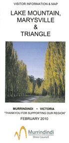
Map (Item) - Tourist map, Murrindindi Shire Council, VISITOR INFORMATION & MAP LAKE MOUNTAIN, MARYSVILLE & TRIANGLE, 02-2010
... the 2009 Black Saturday bushfires destroyed most of the township.... This information guide and map was produced after the 2009 Black Saturday ...A visitor information map for Lake Mountain, Marysville and the local district produced by the Murrindindi Shire Council in February 2010. This information guide and map was produced after the 2009 Black Saturday bushfires destroyed most of the township of Marysville.A visitor information map for Lake Mountain, Marysville and the local district produced by the Murrindindi Shire Council in February 2010.Murrindindi Shire Council has made every effort to ensure the information provided at the time/ of printing is correct, but accepts no responsibility for an inaccuracies or omissions.lake mountain, marysville, victoria, australia, visitor information & map, murrindindi shire council, big 4 holiday park taggerty, black spur inn, black spur motel & caravan park, bush creek buddha, buxton hotel motel, cathedral valley farm, chestnut glade, crossways historic country inn, delderfield luxury b&b, kingbilli country estate, marapana agistment park & farm stay b&b, maryton park b&b, pinjarra gardens, sarsens rest, silverstream b&b, tower motel, willowbank at taggerty, wombat cottage, woodlands rainforest retreat, buxton general store and post office, buxton zoo nursery, cathedral view natural therapies, country touch, cross country ski hire, foodworks, highwood health retreat, lake mountain ski hire, lit & beyond, lj hooker, maroondah outdoor equipment/bait & tackle, marysville medical centre, marysville patisserie, marysville ski centre, marysville triangle real estate, marysville visitor information centre, mystic mountains ski hire/outdoors, pat's hairdressing, penni lanes country wares, plant's by shelian -
 Greensborough Historical Society
Newspaper Clipping, Diamond Valley Leader, Firefighting aircraft boost, 13/09/2017
... bushfires...bushfires ...The largest ever firefighting aircraft fleet will be rolled out in Victoria, ahead of growing bushfire warnings.News article 1 page, black text.firefighting, aircraft, bushfires, bushfire management -
 Greensborough Historical Society
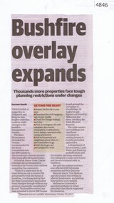
Newspaper Clipping, Diamond Valley Leader, Bushfire overlay expands, 18/10/2017
... bushfires...bushfires ...Thousands of properties in Nillumbik and Banyule face tougher planning controls under changes to bushfire management overlay. News article 1 page, black text.nillumbik, banyule, bushfire management, bushfires -
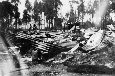 Eltham District Historical Society Inc
Photograph, Thomson's Hotel, Kinglake, after bush fire, 25 February, 1926
... bushfires...bushfires ...Remains of Thomson's Hotel, Kinglake following a bushfire on 25 February 1926.This photo forms part of a collection of photographs gathered by the Shire of Eltham for their centenary project book,"Pioneers and Painters: 100 years of the Shire of Eltham" by Alan Marshall (1971). The collection of over 500 images is held in partnership between Eltham District Historical Society and Yarra Plenty Regional Library (Eltham Library) and is now formally known as 'The Shire of Eltham Pioneers Photograph Collection.' It is significant in being the first community sourced collection representing the places and people of the Shire's first one hundred years.Digital imagesepp, shire of eltham pioneers photograph collection, kinglake, thomson's hotel, bushfires -
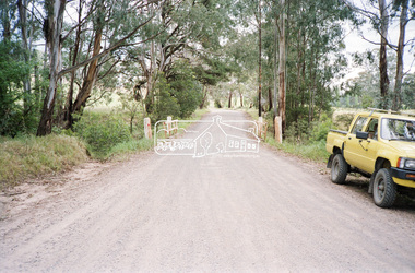 Eltham District Historical Society Inc
Negative - Photograph, Cottlesbridge-Strathewen Road, Strathewen, c.Nov. 1987
... were badly burnt or destroyed in the Black Saturday bushfire, 7... were badly burnt or destroyed in the Black Saturday bushfire, 7 ...Photos taken during a review of road and bridge/culvert condition by Eltham Shire Council engineers. A number of the trees were badly burnt or destroyed in the Black Saturday bushfire, 7 Feb. 2009 but some remained standing and identifiable as of 2014 (Google Streetview).Roll of 35mm colour negative film, 4 stripsKodak GB 200 5096bridge, chads creek, chads creek road, cottlesbridge-strathewen road, culvert, infrastructure, roads, school ridge road, strathewen -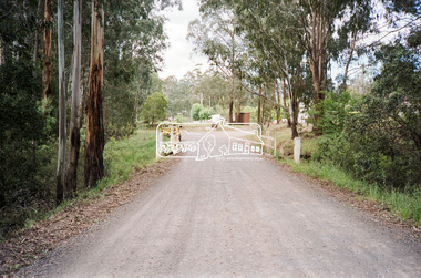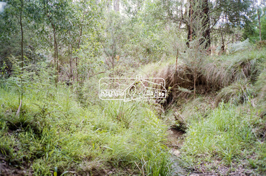
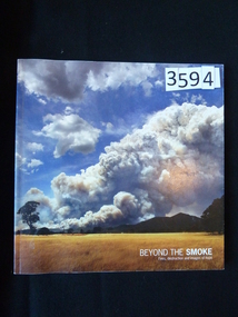 Stawell Historical Society Inc
Book, Parks Victoria, Beyond the Smoke - Fires, Destruction and Images of Hope, 2007
Photographs and Memories of the Grampians and Mt Lubra Fires 2005/06.Card cover of smoke from the 2005/06 fires in the Grampains.Beyond the Smoke Fires, destruction and images of hope Inside: Dedicated to all those touched by wildfirestawell -
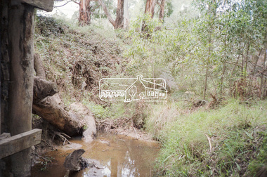
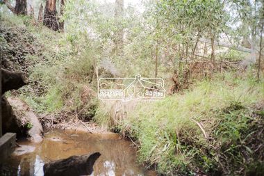
 Greensborough Historical Society
Booklet, Parks Victoria et al, Plenty Gorge Park fire recovery, 15/04/2020
... bushfires...bushfires ...Community update on rehabilitation of the section of Plenty Gorge Park affected by a bushfire in December 20196 p. text and colour photographs and mapplenty gorge park, bushfires, blue lake, yellow gum park, plenty -
 Eltham District Historical Society Inc
Newsletter, Newsletter, No. 186 May 2009
... • May Heritage Walk • Black Saturday Bushfires • Black Friday... • May Heritage Walk • Black Saturday Bushfires • Black Friday ...Contents: • Next meeting, Slide Presentation by Anne Paul; The Lower Plenty River; It’s history and heritage • May Meeting • May Heritage Walk • Black Saturday Bushfires • Black Friday 1851 • Eltham England Contacts • Office Bearers 2009-10 • Harry Gilham, Society President 1993-2009 • Subscriptions • Other News The Shire of Eltham Historical Society was formed in October 1967. The first newsletter of the Society was issued May 1978 and has been published continuously ever since on a bi-monthly basis. With the cessation of the Shire of Eltham in late 1994, the Society's name was revised to Eltham District Historical Society and this name first appeared with issue No. 103, July 1995. The collection of the Society's newsletters provides a valuable resource on the history of the Society's activities, office bearers and committee members, guest speakers and subjects of historical interest pertinent to the former Shire of Eltham and the Eltham District.A4 photocopied newsletter distributed to membersnewsletter, eltham district historical society, shire of eltham historical society -
 Lakes Entrance Historical Society
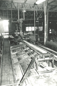
Photograph, Lakes Post Newspaper, Buchan Valley Sawmill, Buchan Victoria, 1/01/1996 12:00:00 AM
Taken during DCNR Forestry tour Black and white photograph of Buchan Valley Sawmill taken on DCNR Forest Management Tour Buchan Victoria. Also a black and white photograph of area burnt out by wildfire but tiny seedlings now appearing. environment, forestry, government services -
 Victorian Interpretive Projects Inc.
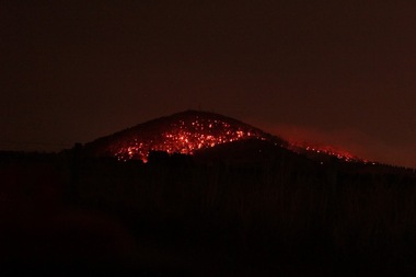
Photograph - Digital, Andrew Matheson, Night View of Fire on Mount Warrenheip, 2013, 15/05/2013
The photographer took these night photos from his home in Bungaree, on close proximity to Mount Warrenheip.A bushfire on Mount Warrenheip, near Ballarat, photographed at night.warrenheip, fire, bushfire, bungaree -
 Orbost & District Historical Society
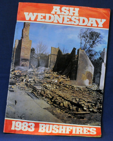
newsaper/magazine, Ash Wednesday, February 1983
... bushfires Ash-Wednesday magazine disasters-Victoria ...This magazine was published to raise money for the State Disaster appeal. It was a tribute to the photographers and reporters who contributed to the coverage of the Ash Wednesday bushfires for these publications.this item is a contemporary record of a major fire disaster in Victoria and is a useful reference tool.A large 78 pp stapled magazine. On the front cover is a coloured photograph of the town of Macedon the morning after the bush fires in February 1983. It has white ASH WEDNESDAY in print on a red background above the photograph and 1983 BUSHFIRES in white print on a red background belop the photograph. The photograph extends to the back cover. The magazine contains black/white photographs, stories and reports.bushfires ash-wednesday magazine disasters-victoria -
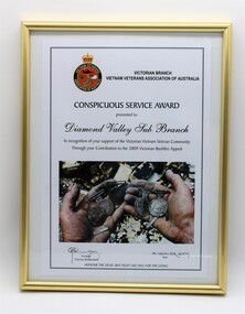 Diamond Valley Vietnam Veterans Sub-Branch
Certificate - VVAA (Vic), 18/12/2009
A record of gratitude for the Sub Branch's assistance to Vietnam veterans after the disastrous bushfires in 2009.Significant to have visible some simple evidence that the Vietnam veteran Sub Branches look after their own if they are experiencing difficulties,Famed Certificate, rectangular in shape in portrait profile, metal frame."Awarded by the Victorian Branch of the Vietnam Veterans Association of Australia to the Diamond Valley Sub Branch in recognition of your support of the Victorian Vietnam Veteran Community Through your Contribution to the 2009 Victorian Bushfire Appeal". Signed by the State President, Bob Elworthy, 18 December 2009. With the organisation's motto at the foot of the Certificate: "HONOUR THE DEAD BUT FIGHT LIKE HELL FOR THE LIVING"diamond valley vietnam veterans sub branch, vvaa (vic) -
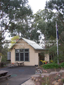 Eltham District Historical Society Inc
Photograph - Digital Photograph, Marguerite Marshall, Strathewen Primary School, 20 August 2008
... in the Black Saturday 2009 bushfires. Land was purchased in 1914... in the Black Saturday 2009 bushfires. Land was purchased in 1914 ...The school building originally owned by locals was lost in the Black Saturday 2009 bushfires. Land was purchased in 1914 to build he Strathewen State School on School Ridge Road, Strathewen. Residents and the Education Department contributed funds for the building which the Education Department then leased for a small annual fee. The school opened with one teacher in 1917 with no equipment. In 1921 the Education Department provided desks and a hexagonal shelter shed and took control in 1925. After this photo was taken, the school was destroyed in Black Saturday on 9 February 2009. Published: Nillumbik Now and Then / Marguerite Marshall 2008; photographs Alan King with Marguerite Marshall.; p89This collection of almost 130 photos about places and people within the Shire of Nillumbik, an urban and rural municipality in Melbourne's north, contributes to an understanding of the history of the Shire. Published in 2008 immediately prior to the Black Saturday bushfires of February 7, 2009, it documents sites that were impacted, and in some cases destroyed by the fires. It includes photographs taken especially for the publication, creating a unique time capsule representing the Shire in the early 21st century. It remains the most recent comprehenesive publication devoted to the Shire's history connecting local residents to the past. nillumbik now and then (marshall-king) collection, strathewen primary school -
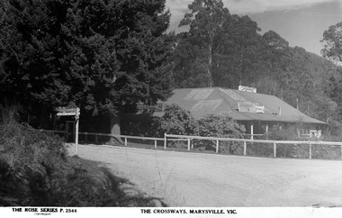 Marysville & District Historical Society
Postcard (Item) - Black and white postcard, Rose Stereograph Company, THE CROSSWAYS, MARYSVILLE, VIC, 1923-1963
... survived the 2009 Black Saturday bushfires thanks to the efforts... survived the 2009 Black Saturday bushfires thanks to the efforts ...A digital copy of a black and white postcard of The Crossways in Marysville produced by the Rose Stereograph Company as a souvenir of Marysville. The Crossways was built in the early 1920s and is the oldest building in Marysville. The Crossways historic inn survived the 2009 Black Saturday bushfires thanks to the efforts of its co-owner Greg Cherry and, in the days after the fires, provided a much-needed refuge to the Marysville community and firefighters.A digital copy of a black and white postcard of The Crossways in Marysville produced by the Rose Stereograph Company as a souvenir of Marysville.marysville, victoria, australia, postcard, rose stereograph company, rose series, p. 2544, souvenir, the crossways, crossways country inn, crossways historic country inn, accommodation -
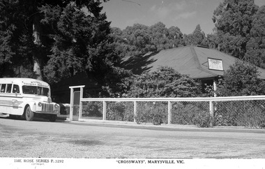 Marysville & District Historical Society
Postcard (Item) - Black and white postcard, Rose Stereograph Company, "CROSSWAYS", MARYSVILLE, VIC, 1923-1963
... survived the 2009 Black Saturday bushfires thanks to the efforts... survived the 2009 Black Saturday bushfires thanks to the efforts ...A digital copy of a black and white postcard of The Crossways in Marysville produced by the Rose Stereograph Company as a souvenir of Marysville. The Crossways was built in the early 1920s and is the oldest building in Marysville. The Crossways historic inn survived the 2009 Black Saturday bushfires thanks to the efforts of its co-owner Greg Cherry and, in the days after the fires, provided a much-needed refuge to the Marysville community and firefighters.A digital copy of a black and white postcard of The Crossways in Marysville produced by the Rose Stereograph Company as a souvenir of Marysville.marysville, victoria, australia, postcard, rose stereograph company, rose series, souvenir, the crossways, crossways country inn, crossways historic country inn, accommodation, p. 3292 -
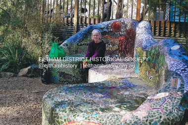 Eltham District Historical Society Inc
Photograph, Fay Bridge, Fay Bridge with the Lasting Memories Mosaic Seat, St. Andrews Hall, 1 Proctor Street, St. Andrews, n.d
... Shire Council's Public Art. Following the Black Saturday... of Nillumbik Shire Council's Public Art. Following the Black Saturday ...The Lasting Memories Mosaic Group Seat is part of Nillumbik Shire Council's Public Art. Following the Black Saturday Bushfire of February 7, 2009, which ravaged St Andrews and surrounding district, a group of bushfire affected women formed the Lasting Memories Mosaic group and created this concrete seat covered in mosaic as part of their healing process. It was completed in 2012. For more information see Nillumbik Shire Council's link Public Art: Lasting Memories Mosaic GROUP, Lasting Memories Mosaic Seat - https://victoriancollections.net.au/items/58536395d0ce201b746561c6fay bridge collection, fay bridge, mosaics, st andrews, lasting memories mosaic group seat, st andrews hall -
Eltham District Historical Society Inc
Photograph, George W. Bell, Eltham Laughing Waters Area, 1965
Black and white photograph of bushfire aftermath Laughing Waters Road Eltham 1965laughing waters road, eltham, fires, bush fires, george w bell collection