Showing 6934 items
matching fire-fighting
-
 National Vietnam Veterans Museum (NVVM)
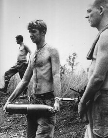
Photograph, Gibbons, Denis, Fire Mission 3
Denis Gibbons (1937 – 2011) Trained with the Australian Army, before travelling to Vietnam in January 1966, Denis stayed with the 1st Australian Task Force in Nui Dat working as a photographer. For almost five years Gibbons toured with nine Australian infantry battalions, posting compelling war images from within many combat zones before being flown out in late November 1970 after sustaining injuries. The images held within the National Vietnam Veterans Museum make up the Gibbons Collection.A black and white photograph of Gnr Jim Dunn, watched by Stg Pete Tilbrook, of 104 Battery RAA, carries a 105mm shell to the gun at Fire Support Base Betty. The battery was in action against NVA/VietCong sappers attempting to breach the US Army Supply Depot at Long Binh in Bien Hoa Province during the 1969 Tet Offensivephotograph, sgt peter tilbrook, gnr jim dunn, 104 battery raa, long binh, bien hoa province, fire base betty, tet offensive, 1969, gibbons collection catalogue, denis gibbons, nva/vietcong sappers, us army supply depot -
 Bendigo Art Gallery
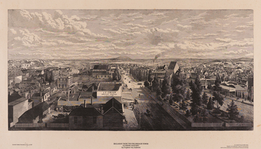
Work on paper, Eugene VON GUERARD, Ballarat from the Fire Brigade Tower (Looking East) 1870, 1870
c.l; Limited Edition number PROOF of 150, c; Ballarat from the Fire Brigade Tower/ (Looking East) 1870/ by Eugene Von Guerard, c.r;; An engraving printed from/Eugene Von Guerards original woodblock/now in the possession of the Ballarat Historical Societywork on paper, print, printmaker, printmaking, australian artist, ballarat, wood engraving, city, town, regional victoria, goldfields -
 Ballarat Fire Brigade
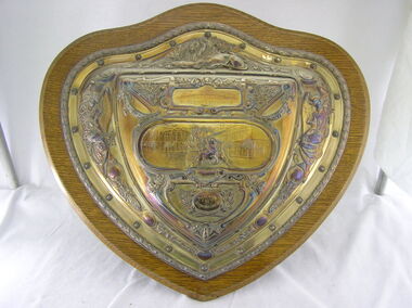
Trophy
Trophy was won at the Geelong Fire Brigade Jubilee in 1904. This would have been a demonstartion to celebrate the 50th Anniversary of the Geelong brigade which formed in 1854Silver shield mounted on a wooden backing board. Trophy was won by Ballarat Fire Brigade at the Geelong Fire Brigade Jubilee in 1904. Trophy was donated by Merrywetather & sons Lim. Trophy has a Lion at the top centre, angels on both the left and right sides. In the centre is a horse drawn fire appliance (assumed a Merryweather steam pumper) drawn by 2 horses through what appears to be a town square. There are 3 fireman standing on the front of the appliance and 1 on the rear. There are various other branches, leaves etc. that make up the remainder of the decorations on the sheild. Item is very similar to item 020.1904 / GEELONG FIRE BRIGADE JUBILEE / COMPETITION / PRESENTED / BY / Merryweather & Sons Lim1904, geelong fire brigade, geelong fire brigade jubilee, merrywether and sons lim, elkington and co -
 Melton City Libraries
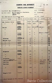
Document, Country Fire Authority Wireless Licence Schedule, 1971
Early member of the Bush Fire Brigade, Bon Barrie saw the need for improved speed of communication. With the formation of the Country Fire Authority by mid 1950 Melton introduced H F high frequency two way radio sets. A set was located in the Barrie home, which was an idea location to observe smoke sighting given its 360 degree view of the distant horizon. A large antenna was built to improve reception and sending strength. Author – Edna Barrie hand written notes. In its policy of creating smaller compact groups of fire brigades the Country Fire Authority Regional Officer Harry Rothsay in 1967 requested that the following 6 brigades surrounding Mt Cottrell transfer from their respective groups. Melton and Rockbank from Bacchus Marsh Group, Toolern Vale and Sydenham from Mt Macedon Group and Truganina and Werribee from Little River Group forming a new Group to the be named Mt Cottrell Fire Brigades Group. Group Headquarters was established at the Ferris road residence of Melton Captain E W Bon Barrie, who was elected Group and Communications Officer of Mt Cottrell. E W (Eddie) Gillespie and Keith Watt of the Toolern Vale brigade were appointed Deputy Group Officer and Group Secretary respectively. The Base Radio was installed at the Group Headquarters by the CFA. Brigades contributed to half the cost. A grant of $1000 was made available by the Shire of Melton in 1969 toward the cost of VHS (Very High Frequency) replacing the HF(High Frequency) Radios which has been introduced in the 1950’s. Shire of Werribee and the City of Keilor supported Werribee and Sydenham in a similar manner. The Call sign for the new group became VL3LY VHF Channel 1 163.12 m/cs. HF 3836 k/cs. Mount Cottrell Group's Wireless Licence Scheduleemergency services, local identities -
 4th/19th Prince of Wales's Light Horse Regiment Unit History Room
Military Insurance Ticket, 1910
Issued to Roy Taylor, a Sergeant in the 9th Australian Light Horse. At that time soldiers had to take out private insurance to cover the risk of death or disablement on duty.Yearly military insurance ticket to cover death or disablement while on military duty. Premium was 7 shillings per annum for cover of 100 pounds for death or 2 pounds/week up to 13 weeks for disablement.No 44998. Signed by Manager and Issuing officerinsurance, military -
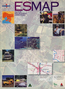 Eltham District Historical Society Inc
Book, Country Fire Authority Mapping Association Inc, ESMAP - Outer Melbourne Directory, 1991
Outer Melbourne directory of information for emergencies with maps of the state and major towns217 p. : maps ; 30 cm.ISBN 0646065661emergency services victoria -
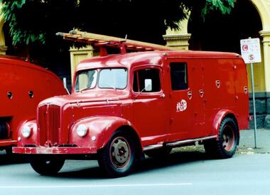 Fire Services Museum of Victoria
Closed Morris Hose Carriage, 1950 Morris Commercial Hose Carrige / Pumper - Car 43, 1950 (estimated)
NVS series Morris Commercial chassis, built in MFB workshops, early 1950's. First enclosed cabin vehicle used by MFB. Fitted with 250 gallon per minute pump.First enclosed cabin vehicle used by MFB.NVS series Morris Commercial chassis, built in MFB workshops, early 1950's. First enclosed cabin vehicle used by MFB. Fitted with 250 gallon per minute pump.Registration number LHW 102, "Car 43".car, fire, morris, commercial, hose, carriage, pumper, 43, truck, 1950 -
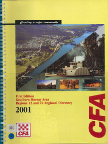 Victorian Aboriginal Corporation for Languages
Map, Country Fire Authority, Goulburn Murray Area regions 12 and 22 regional directory, 2001
mapsgoulburn river, fire protection districts, northern victoria -
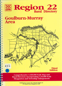 Victorian Aboriginal Corporation for Languages
Map, Country Fire Authority, Region 22 rural directory Goulburn-Murray area, 1997
mapsgoulburn region, fire protection, emergency services, victorian maps, directories -
 Victorian Aboriginal Corporation for Languages
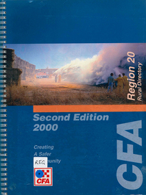
Map, Country Fire Authority, Region 20 rural directory, 2000
mapskerang, regional maps, atlas, fire protection -
 Victorian Aboriginal Corporation for Languages
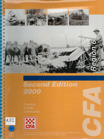
Map, Country Fire Authority, Region 6 rural directory, 2000
maps, b&w photographscolac, lismore, cressy, lake corangamite, camperdown, terang, cobden, peterborough, port campbell, apollo bay, forrest, victorian regional maps, fire protection -
 Victorian Aboriginal Corporation for Languages
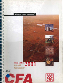
Map, Country Fire Authority, Region 18 rural directory, 2001
Maps, colour photographsswan hill, mildura, mallee, fire protection, emergency services, victorian regional maps -
 Victorian Aboriginal Corporation for Languages
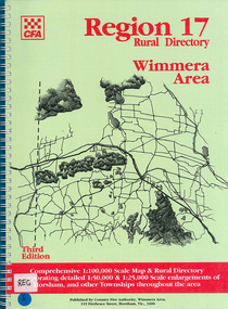
Map, Country Fire Authority, Region 17 rural directory : Wimmera area, 1997
mapshorsham, wimmera, west wimmera, hindmarsh, yarramback, grampians, fire protection, emergency services, victorian regional maps -
 Victorian Aboriginal Corporation for Languages
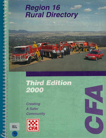
Map, Country Fire Authority, Region 16 rural directory, 2000
maps, colour photographsararat, fire protection, emergency services, maps, victorian regional maps -
 Victorian Aboriginal Corporation for Languages
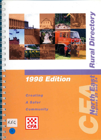
Map, Country Fire Authority, Regions 23 and 24 north east rural directory, 1998
mapswodonga, albury, wangaratta, benalla, maps, victoria, fire protection -
 Victorian Aboriginal Corporation for Languages
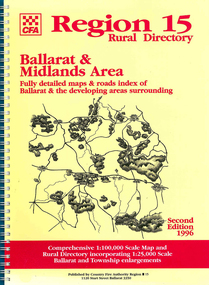
Map, Country Fire Authority, Region 15 rural directory : Ballarat &? Midlands Area : fully detailed maps &? roads index of Ballarat &? the developing areas surrounding, 1996
mapsballarat, fire protection, victorian regional maps, emergency services -
 Victorian Aboriginal Corporation for Languages
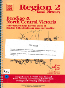
Map, Country Fire Authority, Region 2 rural directory : Bendigo &? North Central Victoria: fully detailed maps &? roads index of Bendigo &? the developing areas surrounding, 1996
mapsbendigo, loddon, fire protection, victorian regional maps, directories -
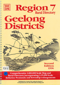 Victorian Aboriginal Corporation for Languages
Map, Country Fire Authority, Region 7 rural directory Geelong districts, 1996
Shows roads, railway, power lines, buildings and emergency locations. Lists property owners.mapsgeelong, regional victoria, fire protection -
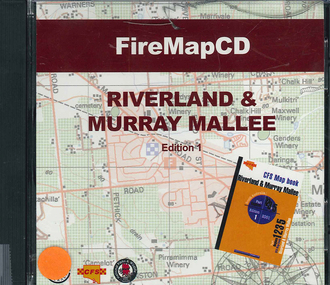 Victorian Aboriginal Corporation for Languages
CD-ROM, Country Fire Services South Australia, FireMapCD Riverland &? Murray Mallee, 2001
The area covered by this map is the same as the CFS Riverland & Murray Mallee Map Book. The area covered adjoins the Mount Lofty Ranges map book on the eastern boundary at Murray Bridge, north to Morgan and east to Renmark and the State Border. It extends southwards to join the northern boundary of the Lower South East map book at Padthaway.CD-ROMfire protection, victorian maps -
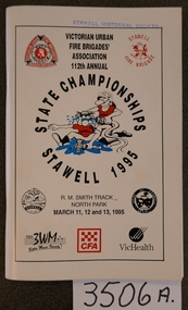 Stawell Historical Society Inc
Booklet, Victorian Urban Fire Brigades, State Championshios Stawell 1995, 1995
stawell -
 Wodonga & District Historical Society Inc
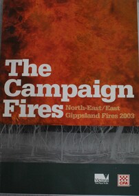
Book - The Campaign Fires - North-East/East Gippsland Fires 2003, Lyndel Hunter, 2003
A description of efforts to fight the bushfires in Gippsland in 2003, including maps and illustrations This volume was published as a tribute to the work of staff and volunteers who put themselves at risk to protect local communities. It shows the impact on those communities in Victoria and the support they gave to those involved in fighting largest bushfires in Victoria for 60 years. The Alpine bushfires started on 8 January 2003, a day of Total Fire Ban. Lightning ignited 87 fires in the North-East and East Gippsland regions. Eight of these fires were unable to be contained; they joined together to form the largest fire in Victoria since the Black Friday fires in 1939. The majority of the area burnt in Victoria was public land, 1.19 million hectares of parks and forests, including 60 per cent of the Alpine National Park and 81 per cent of the Mt Buffalo National Park. Firefighting efforts were made difficult in hard to access, remote forest terrain. Approximately 90,000 hectares of private land was burnt.This publication of 119 pages features text, colour images, maps and detailed information related to the 2003 bushfires in Victoria.non-fictionA description of efforts to fight the bushfires in Gippsland in 2003, including maps and illustrations This volume was published as a tribute to the work of staff and volunteers who put themselves at risk to protect local communities. It shows the impact on those communities in Victoria and the support they gave to those involved in fighting largest bushfires in Victoria for 60 years. The Alpine bushfires started on 8 January 2003, a day of Total Fire Ban. Lightning ignited 87 fires in the North-East and East Gippsland regions. Eight of these fires were unable to be contained; they joined together to form the largest fire in Victoria since the Black Friday fires in 1939. The majority of the area burnt in Victoria was public land, 1.19 million hectares of parks and forests, including 60 per cent of the Alpine National Park and 81 per cent of the Mt Buffalo National Park. Firefighting efforts were made difficult in hard to access, remote forest terrain. Approximately 90,000 hectares of private land was burnt.forest fires -- victoria, bushfires, fires prevention and control -
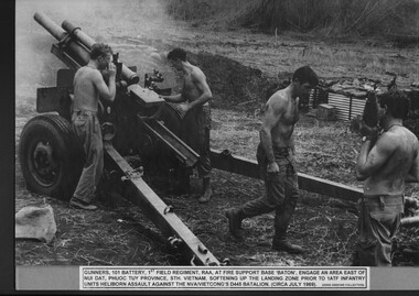 National Vietnam Veterans Museum (NVVM)
Photograph, Gibbons, Denis, Fire Support Base Baton 1
A black and white photograph of Gunners of 101 Battery 1st Australian Field Regt RAA at Fire Support Base Baton engage an area east of Nui Dat, Phuoc Tuy Province, Sth Vietnam softening up the landing zone prior to 1 ATF Infantry units heliborn assault against NVA/VietCong's D445 Battalion (circa July 1969)photograph, 101 battery, 1st australian field regiment, raa, 1st atf base, nui dat, phuoc tuy province, fire support base baton, nva/vc, d445 battalion (nva/vietcong), gibbons collection catalogue, gunner -
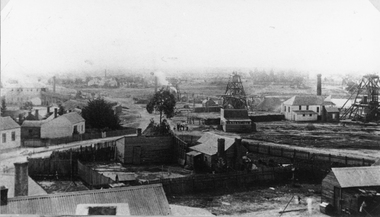
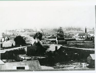 Stawell Historical Society Inc
Photograph, Double story building on left is Lamont Crushing Battery & on the right is the Oriental Mine looking from the top of the Fire Station c1880's
Photograph taken from the top of the Fire Station 1880's Double story building on left is Lamont Crushing Battery. Behind tree North Cross Reef Mine. Centre No 1 North Cross Reef Mine. On right Oriental Mine.stawell mining -
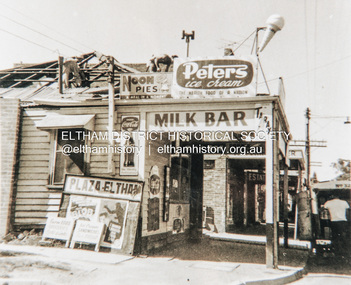 Eltham District Historical Society Inc
Photograph, Fire damaged milk bar, Main Road, Eltham, c.1960, 1960c
Fire damaged milk bar, Main Road, Eltham near Arthur Street. Film poster is advertising The Blob (1958) and "I married a monster from outer space" (1958) which both appear to have been screened in Australia in 1960 and 1961Colour photograph copy of originalshops, main road, eltham, fire, the blob (1958 film), i married a monster from outer space (1958 film) -
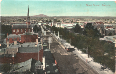 Ballarat Tramway Museum
Postcard, "Sturt St Ballarat" - from fire station, c1910
Photograph - looking east along Sturt Street from the Ballarat City Fire station tower. Shows a ESCo tram east bound. Mount Warrenheip can be seen in the far distance along with St Patrick's Cathedral and the St Andrews Scots church.Yields information about the streetscape of Sturt St.Postcard coloured, divided back, unused, Valentine & Sons.tramways, trams, esco, sturt st -
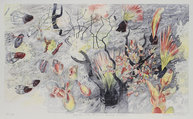 Merri-bek City Council
Lithograph, John Wolseley, After the Fire - Leaf Surge, 2003
British born artist John Wolseley relocated to Australia in 1976, where he travelled extensively through the outback mainly recording the natural history of remote north Australia in large, minutely detailed paintings. Since 2009, he has travelled to Darwin annually to continue his exploration of the Top End, visiting Arnhem Land and Daly River to work with Indigenous artists to research and capture the detail and essence of particular landscapes. His works reflect how landscape can be thought of as fields of energy in which plant forms move or dance with rhythmic life. After The Fire - Leaf Surge represents the vibrant regrowth of new foliage emerging from a landscape recently ravaged by fire. -
Tatura Irrigation & Wartime Camps Museum
Book - recipe, Collected Favourites, 1990's
Printed as a fund-raiser for the Tatura Fire Brigade Ladies Auxiliary.White covered recipe book with red writing and logo on front cover. 48 pages.Tatura Urban Fire Brigade. Always Ready. Ladies Auxiliary.tatura fire brigade ladies auxiliary, recipe books, fund raising in tatura -
 Stawell Historical Society Inc
Photograph, Oriental Gold Mining Company c1880's. Mining Scene looking North probably from Fire Station Tower
Mining Scene looking North probably from Fire Station. Grant and Lamont's Battery in corner left side, in background of photograph. In Centre right is No1 North Cross Reef Mine. On left behind the tree is No2 North Cross Reef Mine. On right is Oriental Mine.Houses and yard in foreground. Poppet heads to right of centre and right Crushing Battery on left of image.stawell mining -
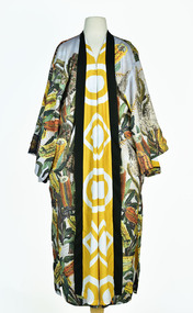 National Wool Museum
Textile - Cloak, Dr Deanne Gilson, Banksia Tree Cloak (water and fire business), 2022
Standing proud, still here, the spirit of ten ancestral matriarchs adorned in contemporary ceremonial cloaks. Representing our women past, present and future, her Spirit, our culture, our Country (spelt with a capital for its importance and this is part of First Peoples protocols on acknowledging Country, our strength, our resilience and healing towards a sustainable future).The sacred banksia tree was a favourite for Wadawurrung people. Flowering before deep Winter, the banksia was used for spear making and other wooden tools. The sap was drunk as a sweet drink and the seed pods used for water straining and fire sticks. The banksia tree flowers at the time when fire sticks farming is practiced marking the days before the coldest days and nights and the hotter days.White, orange, and yellow banksia design on outer cloak, yellow and white circle and diamond design in lining. Solid black trimming. Cloak is machine sewn and handstitched with hand stitching on shoulder seam.deanne gilson, wadawurrung dja, first nations art, cloak -
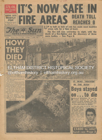 Eltham District Historical Society Inc
Newspaper - Newspaper articles, Sun News-Pictorial, It's Now Safe in Fire Areas; Death Toll Reacxhes 8, The Sun News-Pictorial, Thursday, January 18, p1, 1962
Various news articles pertaining to the January 1962 Victorian bushfires in the Dandenong and Healesville districts which by the third day had encompassed large areas of the State. Specific Eltham Shire districts mentioned include Warrandyte on page 1, St. Andrews and Smith’s Gully on page 2, St. Andrews on page 3 and 43, Panton Hill and Warrandyte on p23 and Hurstbridge on page 44 • It's Now Safe in Fire Areas; Death Toll Reaches 8, p1 (Illust.) • How they died, pp1-2 • It was “heaven” in the bush … Boys stayed on . . . to die, pp1-2 (Illust.) • Towns take stock as danger drops, p2 • £5400 to the relief fund, p2 • Fire now threat to Otways, p2 • Pensioners lose all, p2 • “…If Only The Rain Had Come” … and then it came to town, p3 (Illust.) • Our best rain since May • It halted at Grandma’s front gate, p5 (Illust.) • Now that the rain has come; It’s time for the clean-up, p6 • Wisps of smoke where flames danced, p7 • Charitry’s a loser, p7 • War Service homes claim, p7 • Help’s on way, p7 (Illust.) • Came with their gifts …, p7 • Fire summons for youth; “sparked the rest”, p9 • Three gaoled, p9 • They had to camp out at Wye River, p9 (Illust.) • “Probe Fires” – Stoneham, p9 • The Fourth Day: Scorched Earth!, pp22-23 (Illust.) • This home was saved but - , p22 (Illust.) • Relief Centre, p23 (Illust.) • Homeless, p23 (Illust.) • So little was left, p43 (Illust.) • Tommy saved his cat, p43 (Illust.) • Some were lucky … and some were tired, p44 (Illust.) tom fielding collection, victorian bushfires - 1962, victorian bushfires – 1962, ronald ockwell, geoffrey ockwell, woori yallock, william ockwell, leslie ockwell, linda may ockwell, black friday, victorian bushfires – 1939, warrandyte, arthur brown, harold vernon betton, bloom road, william smith, olinda, bushfire relief fund, yarra glen, healesville, railway line, st. andrews, smith’s gully, otway ranges, eric watts, edith varty, inverness road, mt. evelyn, wye river, panton hil, heather sullivan, warrandyte hall, montrose, kalorama, mrs e. tucker, shirley tucker, margaret tucker, joane tucker, roger tucker, trevor tucker, ann quinton, tom dunstan, hurstbridge hall