Showing 2350 items matching "framed photos"
-
 Eltham District Historical Society Inc
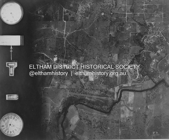
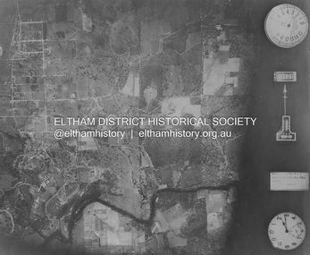
Photograph - Aerial Photograph, Landata, Eltham; Crown Allotment 15, Section 5, Parish of Nillumbik (Stokes Orchard Estate), Mar. 1987
Centred on present day Diosma Rd, Stokes Pl, Nyora Rd and Eucalyptus Rd Historic Aerial Imagery Source: Landata.vic.gov.au Aerial Photo Details: Project No :1716 Project : WESTERN PORT FORESHORES Run : 15 Frame : 108 Date : 03/1987 Film Type : B/W Camera : RC10 Flying Height : 5600 Scale : 10000 Film Number : 4102 GDA2020 : 37°43'00"S, 145°10'13"E MGA2020 : 338725, 5824036 (55) Melways : 22 D5 (ed. 42)719 (55) Melways : 22 D4 (ed. 42) A History of the Development of Crown Allotment 15, Section 5, Parish of Nillumbik – Stokes Orchard Crown Allotment 15, Section 5, Parish of Nillumbik (CA15) is a square allotment of 158 acres or approximately a quarter of a square mile. It lies just beyond the eastern end of Pitt Street, south of Nyora Road to the northern end of Eucalyptus Road and extends east from Eucalyptus Road to Reynolds Road. The topography of CA15 is generally steep, sloping up to a hill near the centre of the land, the ridgeline passing through the properties along the southern side of Diosma Road. Eucalyptus Road is a straight north-south road with its northern end at the north west corner of CA15. Until the end of the 1970s this road was an un-named Government Road and was largely not open to traffic. With residential development in the 1970s the road was constructed, and the council allocated the name obviously in recognition of the predominant species of the local bushland. CA15 was purchased from the Crown by George D’Arley Boursiquot, a prominent Melbourne printer, on 28th October 1852. On November 23, 1922, former Member for Gippsland and Melbourne Real Estate Agent, Hubert Patrick Keogh purchased the allotment then sold it March 13, 1925, to local farmer, Robert David Taylor, a former Shire of Eltham Councillor (1911-1920) and Shire President (1919). Taylor had extensive land holdings stretching west towards Bible Street and Main Road. The Taylor home was situated at the top of the hill in Bible Street at present day 82 Bible Street. At the time of Taylor’s purchase in 1925, CA15 was subdivided into 48 lots that could be described as small rural properties or large residential lots. A typical lot size was one hectare or 2.5 acres. The subdivision created two roads, Nyora Road, and Diosma Road, each following an irregular alignment between Eucalyptus and Reynolds Roads. However, the lots were not sold off separately nor were the roads constructed. The land effectively remained as one parcel for many further years. Robert David Taylor died November 30, 1934, and probate was granted to his son of the same name, Robert David Taylor of Bible Street, Salesman and William McLelland Vance Taylor of 73 Emmeline Street, Northcote, Clerk, with the transfer of the land into their names on July 8, 1935. Frank Stokes worked as a qualified accountant at Kennons leather factory in Burnley, while living at 1 Thomas Street, Mitcham. He suffered from migraines and wanted to return to working the land (he had previously worked on farms and orchards since coming to Australia from England in 1926, both in WA and Vic.). He first travelled to the district by train in July 1942 to find land with the intention to establish an orchard. By chance he met Arthur Bird of Bird Orchard (bounded by Pitt Street, Eucalyptus Road, and Wattle Grove) and they got talking over their common interest. Arthur put Frank up for the night and pointed out the land, 158 acres- part of the Taylor Estate- £900, Crown Allotment 15, Section 5, Parish of Nillumbik (CA15) somewhat diagonally opposite Bird Orchard. Stokes applied through the Riverina Agency to purchase the land who in turn applied for permission from Canberra to sell as there was a new government regulation introduced during the Second World War banning land sales except for immediate production. Stokes obtained a loan on his Mitcham house of £600 @ 5% and paid £450 deposit with quarterly payments of £15 spread over 5 years. Stokes was assisted and advised by Arthur Bird who farmed the neighbouring orchard. In early 1943 Stokes took possession and would catch the train out to Eltham on Fridays after work and began building a hut on the corner of Nyora Road and the Government Road (Eucalyptus Road) for shelter and to lock up tools. He established an orchard on the central western part of the land through the centre of which ran a natural waterway (part of the present-day linear park) and was able to pay a neighbour (Hawkins) to help with clearing and fencing 25 acres, and with a horse and single furrowed plough, planted approximately 2,500 fruit trees - cherries, peaches, plums, almonds, pears, apricots and lemons as well as a few apples and oranges; a massive task. Aerial photographs from the 1940s through to the 1990s clearly show the orchard with most of the larger CA15 site remaining as natural bushland. A huge problem was hares and rabbits eating all the new buds off the tiny trees. As well as laying poison he painted the trees with a mixture of cow manure and lime, often working by moonlight. Procurement of wire and wire netting was difficult because of the war but after much effort he obtained a permit from the Agricultural Department for supplies in March 1944. In February 1945 Stokes applied for a permit to build a “packing shed” as no house building was allowed. It was to be 33 feet x 21 feet and cost £312. It was constructed mostly from second-hand materials, which were hard to obtain, especially iron for roofing. Stokes finished work at Kennons on October 31, 1945, and in March 1946 he sold the family home at Mitcham for £1,230 plus £170 for furniture. On May 15, 1946, title to the CA15 property was issued to Frank Howard Alfred Stokes, Orchardist and Gladys Ethel Stokes, Married Woman, both of Pitt Street, Eltham. The family of five then moved into the very unfinished “packing shed” at Eltham, which was a struggle to weatherproof. Eventually rooms were divided off and lined with hessian bags and whitewashed. Their income was firewood (cut and sold), selling rockery stones and cut Sweet Bursaria. (It was discovered during the 1940s that Sweet Bursaria contained the sunscreen compound Aesculin. The RAAF utilised this compound from Sweet Bursaria during WW2 for pilots and gunners.) The orchard’s first fruit sale was a half-case of Le Vanq peaches in December 1947 for the price of 8 shillings. In 1956 plans for house were drawn and Glen Iris bricks purchased (1956 Olympic Rings variant). The building of the house commenced in 1957 - 12 feet of original packing shed was removed – and was completed in 1959. Water was connected from newly built pressure storage on the property at the end of 1959 and the electricity connection for the first time at 3pm on April 29, 1960. The house remains to present day (somewhat modified) at 1 Nyora Road, home to Nyora Studio Gallery. On occasions, spare remnants of the 1956 bricks have been known to be unearthed in gardens on the estate as they were utilised by Frank Stokes to fill in rabbit holes. On May 26, 1950, a parcel of land was compulsorily acquired by the Melbourne and Metropolitan Board of Works on the hilltop to establish an easement for a high-level service reservoir to augment Eltham’s water supply. The project also included pipe tracks for the necessary water mains. The reservoir has now been superseded by higher level water tanks east of Reynolds Road and its former site is now a public reserve. On November 27, 1964, the State Electricity Commission served notice to compulsorily acquire a further parcel through the eastern part of the land for a major electricity transmission line that augmented supply from the La Trobe Valley to Melbourne. The easement was registered February 11, 1966. The easement was widened July 18, 1969 for a second transmission line to be constructed. In 1971 Melbourne Metropolitan Planning Scheme amendments adopted Nyora Road as the boundary between a residential zone to the north and a rural zone to the south. This determined the future development of the land. In the mid-1970s the Shire of Eltham divided the orchard into numerous rate-able parcel lots, the 48 lots having been established in 1925 and the subsequent rates assessment proved unsustainable for Stokes. He commenced selling lots outside the boundary of the orchard, north of Diosma and South of Nyora. However shortly later the land between Nyora and Diosma Roads and west of the electricity easement was sold and subdivided into residential lots, a housing development by Macquarie Builders and marketed as the Stokes Orchard Estate. New streets were created, and most were named after trees, although one, Stokes Place, commemorates the former owners. The development was undertaken in two stages; Stage 1 (1975) encompassing Scarlet Ash Court, Ironbark Close and Peppermint Grove bounded by Nyora and Eucalyptus roads and Stage 2 (1978) encompassing Stokes Place, Orchard Way, The Crest and The Lookout bound by Nyora and Diosma roads. The developer, Macquarie Builders went bankrupt shortly after the release of Stage 2 leaving many purchasers to fend for themselves and arrange for their own independent builders. There were also difficulties with sewerage for the land immediately south of Diosma Road and so the conventional residential lots were abandoned in favour of larger lots. The development of Orchard Way, The Crest and The Lookout did not proceed as planned and the proposed lots were incorporated into five-acre parcels instead. These included a low-density group housing development by the Graves family and the award winning Choong House (1983) with Gordon Ford developed garden immediately next door situated on the ridge of the hill nestled amongst the original bush, Eucalypt trees and Sweet Bursaria. In 1994, Nillumbik Shire Council applied Significant Environment and Significant Landscape overlays upon the properties on the south side of Diosma Road to ensure protection of this natural bush garden environment. With the arrival of the sewer along Diosma Road in the 1990s, most of these five-acre parcels have since been subdivided multiple times. The Choong house presently sits on a 2.7-acre property, which in 2022 Nillumbik Council nominated for Cultural Significance Heritage protection and is considered potentially significant at State level. The Stokes family were also associated with the Eltham Christian Church. In the 1970s this church had met in temporary premises in Eltham. Lots of the original 1925 subdivision remained south of Nyora Road and a number of these lots were utilized for the Eltham Christian School, which was established by the Eltham Christian Church in 1981. The school operated on this site until 2000. The premises are now used by The Vine Baptist Church. By the mid-1980s the whole of CA15 had been developed for residential and school purposes, except for the sections north of Diosma Road and between the transmission lines and Reynolds Road. Sewerage issues had been resolved for the section north of Diosma Road and in 1987 it was in the process of being subdivided into residential lots. The development coincided with the discovery of colonies of the rare and endangered Eltham Copper Butterfly on the site. This resulted in a community and political campaign to save the butterfly habitat. With the co-operation of the land developer the subdivision was altered to create two bushland reserves in the critical butterfly habitat areas. In the late 1980s the State Government was investigating options for establishing a metropolitan ring road link between Diamond Creek and Ringwood. The chosen route was adjacent to Reynolds Road and so this created a freeze on development of CA15 between Reynolds Road and the electricity easement. The ring road proposal was eventually abandoned, and this part of the land was subdivided into low density residential lots. Diosma Road has been discontinued at the electricity easement and the eastern part incorporated into View Mount Court with access from Reynolds Road. The whole of CA15 has now been developed for residential or associated purposes, ranging from conventional density to quite low density south of Nyora Road. Some remnants of the orchard remain, a few cherry trees on the Graves property and a lone apple tree in Stokes Place. The butterfly reserves comprise significant areas of remnant bushland. Linear reserves through the estate link with central Eltham via the Woodridge linear reserve and with Research along the electricity easement. CA15 as it exists today has a complicated history of rural use, Government acquisition, urban development, and community action. References: • “Stokes Orchard, an incomplete history”; Russell Yeoman with Doug Orford • Correspondence, Beryl Bradbury (nee Stokes) • Aerial Photographs, 1931-1991, Landata (landata.vic.gov.au) • Certificate of Title, Vol. 4930 Fol. 985900 • Plan Number LP 10859 aerial photo, diosma road, eltham copper butterfly, eucalyptus road, ironbark close, nyora road, peppermint grove, peter & elizabeth pidgeon collection, power transmission lines, reynolds road, scarlet ash court, stokes orchard estate, stokes place, woodridge estate, frank stokes -
 Eltham District Historical Society Inc
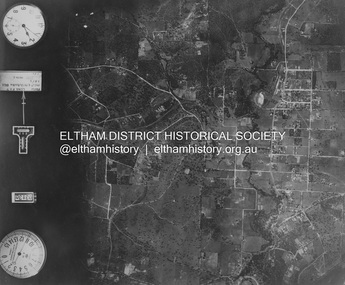
Photograph - Aerial Photograph, Landata, Eltham; Crown Allotment 15, Section 5, Parish of Nillumbik (Stokes Orchard Estate), Sep. 1991
Centred on present day Diosma Rd, Stokes Pl, Nyora Rd and Eucalyptus Rd Historic Aerial Imagery Source: Landata.vic.gov.au Aerial Photo Details: Project No :2072 Project : MELBOURNE PROJECT Run : 13 Frame : 119 Date : 09/1991 Film Type : COL Camera : RC10 Flying Height : 8300 Scale : 15000 Film Number : 4419 GDA2020 : 37°43'07"S, 145°09'35"E MGA2020 : 337812, 5823811 (55) Melways : 22 B6 (ed. 42) A History of the Development of Crown Allotment 15, Section 5, Parish of Nillumbik – Stokes Orchard Crown Allotment 15, Section 5, Parish of Nillumbik (CA15) is a square allotment of 158 acres or approximately a quarter of a square mile. It lies just beyond the eastern end of Pitt Street, south of Nyora Road to the northern end of Eucalyptus Road and extends east from Eucalyptus Road to Reynolds Road. The topography of CA15 is generally steep, sloping up to a hill near the centre of the land, the ridgeline passing through the properties along the southern side of Diosma Road. Eucalyptus Road is a straight north-south road with its northern end at the north west corner of CA15. Until the end of the 1970s this road was an un-named Government Road and was largely not open to traffic. With residential development in the 1970s the road was constructed, and the council allocated the name obviously in recognition of the predominant species of the local bushland. CA15 was purchased from the Crown by George D’Arley Boursiquot, a prominent Melbourne printer, on 28th October 1852. On November 23, 1922, former Member for Gippsland and Melbourne Real Estate Agent, Hubert Patrick Keogh purchased the allotment then sold it March 13, 1925, to local farmer, Robert David Taylor, a former Shire of Eltham Councillor (1911-1920) and Shire President (1919). Taylor had extensive land holdings stretching west towards Bible Street and Main Road. The Taylor home was situated at the top of the hill in Bible Street at present day 82 Bible Street. At the time of Taylor’s purchase in 1925, CA15 was subdivided into 48 lots that could be described as small rural properties or large residential lots. A typical lot size was one hectare or 2.5 acres. The subdivision created two roads, Nyora Road, and Diosma Road, each following an irregular alignment between Eucalyptus and Reynolds Roads. However, the lots were not sold off separately nor were the roads constructed. The land effectively remained as one parcel for many further years. Robert David Taylor died November 30, 1934, and probate was granted to his son of the same name, Robert David Taylor of Bible Street, Salesman and William McLelland Vance Taylor of 73 Emmeline Street, Northcote, Clerk, with the transfer of the land into their names on July 8, 1935. Frank Stokes worked as a qualified accountant at Kennons leather factory in Burnley, while living at 1 Thomas Street, Mitcham. He suffered from migraines and wanted to return to working the land (he had previously worked on farms and orchards since coming to Australia from England in 1926, both in WA and Vic.). He first travelled to the district by train in July 1942 to find land with the intention to establish an orchard. By chance he met Arthur Bird of Bird Orchard (bounded by Pitt Street, Eucalyptus Road, and Wattle Grove) and they got talking over their common interest. Arthur put Frank up for the night and pointed out the land, 158 acres- part of the Taylor Estate- £900, Crown Allotment 15, Section 5, Parish of Nillumbik (CA15) somewhat diagonally opposite Bird Orchard. Stokes applied through the Riverina Agency to purchase the land who in turn applied for permission from Canberra to sell as there was a new government regulation introduced during the Second World War banning land sales except for immediate production. Stokes obtained a loan on his Mitcham house of £600 @ 5% and paid £450 deposit with quarterly payments of £15 spread over 5 years. Stokes was assisted and advised by Arthur Bird who farmed the neighbouring orchard. In early 1943 Stokes took possession and would catch the train out to Eltham on Fridays after work and began building a hut on the corner of Nyora Road and the Government Road (Eucalyptus Road) for shelter and to lock up tools. He established an orchard on the central western part of the land through the centre of which ran a natural waterway (part of the present-day linear park) and was able to pay a neighbour (Hawkins) to help with clearing and fencing 25 acres, and with a horse and single furrowed plough, planted approximately 2,500 fruit trees - cherries, peaches, plums, almonds, pears, apricots and lemons as well as a few apples and oranges; a massive task. Aerial photographs from the 1940s through to the 1990s clearly show the orchard with most of the larger CA15 site remaining as natural bushland. A huge problem was hares and rabbits eating all the new buds off the tiny trees. As well as laying poison he painted the trees with a mixture of cow manure and lime, often working by moonlight. Procurement of wire and wire netting was difficult because of the war but after much effort he obtained a permit from the Agricultural Department for supplies in March 1944. In February 1945 Stokes applied for a permit to build a “packing shed” as no house building was allowed. It was to be 33 feet x 21 feet and cost £312. It was constructed mostly from second-hand materials, which were hard to obtain, especially iron for roofing. Stokes finished work at Kennons on October 31, 1945, and in March 1946 he sold the family home at Mitcham for £1,230 plus £170 for furniture. On May 15, 1946, title to the CA15 property was issued to Frank Howard Alfred Stokes, Orchardist and Gladys Ethel Stokes, Married Woman, both of Pitt Street, Eltham. The family of five then moved into the very unfinished “packing shed” at Eltham, which was a struggle to weatherproof. Eventually rooms were divided off and lined with hessian bags and whitewashed. Their income was firewood (cut and sold), selling rockery stones and cut Sweet Bursaria. (It was discovered during the 1940s that Sweet Bursaria contained the sunscreen compound Aesculin. The RAAF utilised this compound from Sweet Bursaria during WW2 for pilots and gunners.) The orchard’s first fruit sale was a half-case of Le Vanq peaches in December 1947 for the price of 8 shillings. In 1956 plans for house were drawn and Glen Iris bricks purchased (1956 Olympic Rings variant). The building of the house commenced in 1957 - 12 feet of original packing shed was removed – and was completed in 1959. Water was connected from newly built pressure storage on the property at the end of 1959 and the electricity connection for the first time at 3pm on April 29, 1960. The house remains to present day (somewhat modified) at 1 Nyora Road, home to Nyora Studio Gallery. On occasions, spare remnants of the 1956 bricks have been known to be unearthed in gardens on the estate as they were utilised by Frank Stokes to fill in rabbit holes. On May 26, 1950, a parcel of land was compulsorily acquired by the Melbourne and Metropolitan Board of Works on the hilltop to establish an easement for a high-level service reservoir to augment Eltham’s water supply. The project also included pipe tracks for the necessary water mains. The reservoir has now been superseded by higher level water tanks east of Reynolds Road and its former site is now a public reserve. On November 27, 1964, the State Electricity Commission served notice to compulsorily acquire a further parcel through the eastern part of the land for a major electricity transmission line that augmented supply from the La Trobe Valley to Melbourne. The easement was registered February 11, 1966. The easement was widened July 18, 1969 for a second transmission line to be constructed. In 1971 Melbourne Metropolitan Planning Scheme amendments adopted Nyora Road as the boundary between a residential zone to the north and a rural zone to the south. This determined the future development of the land. In the mid-1970s the Shire of Eltham divided the orchard into numerous rate-able parcel lots, the 48 lots having been established in 1925 and the subsequent rates assessment proved unsustainable for Stokes. He commenced selling lots outside the boundary of the orchard, north of Diosma and South of Nyora. However shortly later the land between Nyora and Diosma Roads and west of the electricity easement was sold and subdivided into residential lots, a housing development by Macquarie Builders and marketed as the Stokes Orchard Estate. New streets were created, and most were named after trees, although one, Stokes Place, commemorates the former owners. The development was undertaken in two stages; Stage 1 (1975) encompassing Scarlet Ash Court, Ironbark Close and Peppermint Grove bounded by Nyora and Eucalyptus roads and Stage 2 (1978) encompassing Stokes Place, Orchard Way, The Crest and The Lookout bound by Nyora and Diosma roads. The developer, Macquarie Builders went bankrupt shortly after the release of Stage 2 leaving many purchasers to fend for themselves and arrange for their own independent builders. There were also difficulties with sewerage for the land immediately south of Diosma Road and so the conventional residential lots were abandoned in favour of larger lots. The development of Orchard Way, The Crest and The Lookout did not proceed as planned and the proposed lots were incorporated into five-acre parcels instead. These included a low-density group housing development by the Graves family and the award winning Choong House (1983) with Gordon Ford developed garden immediately next door situated on the ridge of the hill nestled amongst the original bush, Eucalypt trees and Sweet Bursaria. In 1994, Nillumbik Shire Council applied Significant Environment and Significant Landscape overlays upon the properties on the south side of Diosma Road to ensure protection of this natural bush garden environment. With the arrival of the sewer along Diosma Road in the 1990s, most of these five-acre parcels have since been subdivided multiple times. The Choong house presently sits on a 2.7-acre property, which in 2022 Nillumbik Council nominated for Cultural Significance Heritage protection and is considered potentially significant at State level. The Stokes family were also associated with the Eltham Christian Church. In the 1970s this church had met in temporary premises in Eltham. Lots of the original 1925 subdivision remained south of Nyora Road and a number of these lots were utilized for the Eltham Christian School, which was established by the Eltham Christian Church in 1981. The school operated on this site until 2000. The premises are now used by The Vine Baptist Church. By the mid-1980s the whole of CA15 had been developed for residential and school purposes, except for the sections north of Diosma Road and between the transmission lines and Reynolds Road. Sewerage issues had been resolved for the section north of Diosma Road and in 1987 it was in the process of being subdivided into residential lots. The development coincided with the discovery of colonies of the rare and endangered Eltham Copper Butterfly on the site. This resulted in a community and political campaign to save the butterfly habitat. With the co-operation of the land developer the subdivision was altered to create two bushland reserves in the critical butterfly habitat areas. In the late 1980s the State Government was investigating options for establishing a metropolitan ring road link between Diamond Creek and Ringwood. The chosen route was adjacent to Reynolds Road and so this created a freeze on development of CA15 between Reynolds Road and the electricity easement. The ring road proposal was eventually abandoned, and this part of the land was subdivided into low density residential lots. Diosma Road has been discontinued at the electricity easement and the eastern part incorporated into View Mount Court with access from Reynolds Road. The whole of CA15 has now been developed for residential or associated purposes, ranging from conventional density to quite low density south of Nyora Road. Some remnants of the orchard remain, a few cherry trees on the Graves property and a lone apple tree in Stokes Place. The butterfly reserves comprise significant areas of remnant bushland. Linear reserves through the estate link with central Eltham via the Woodridge linear reserve and with Research along the electricity easement. CA15 as it exists today has a complicated history of rural use, Government acquisition, urban development, and community action. References: • “Stokes Orchard, an incomplete history”; Russell Yeoman with Doug Orford • Correspondence, Beryl Bradbury (nee Stokes) • Aerial Photographs, 1931-1991, Landata (landata.vic.gov.au) • Certificate of Title, Vol. 4930 Fol. 985900 • Plan Number LP 10859 aerial photo, diosma road, eltham copper butterfly, eucalyptus road, ironbark close, nyora road, peppermint grove, peter & elizabeth pidgeon collection, power transmission lines, reynolds road, scarlet ash court, stokes orchard estate, stokes place, woodridge estate, frank stokes -
 Eltham District Historical Society Inc
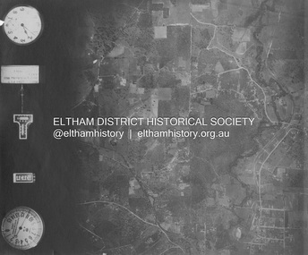
Photograph - Aerial Photograph, Landata, Eltham and Lower Plenty, Nov. 1931
Centred over present-day Rosehill Road and View Road, Lower Plenty Historic Aerial Imagery Source: Landata.vic.gov.au Aerial Photo Details: Project No :1931 Project : MALDON PRISON Run : 19 Frame : 3129 Date : 11/1931 Film Type : B/W Camera : F8 Flying Height : 11000 Scale : 18860 Film Number : 60 GDA2020 : 37°44'16"S, 145°07'40"E MGA2020 : 335039, 5821622 (55) Melways : 21 E11 (ed. 42)aerial photo, eltham, lower plenty, neil webster collection, rosehill road, view road -
 Eltham District Historical Society Inc
Photograph - Aerial Photograph, Landata, Eltham and Montmorency, Nov. 1931
Centred over present-day Belmont Reserve, Montmorency Historic Aerial Imagery Source: Landata.vic.gov.au Aerial Photo Details: Project No :1931 Project : MALDON PRISON Run : 19 Frame : 3130 Date : 11/1931 Film Type : B/W Camera : F8 Flying Height : 11000 Scale : 18860 Film Number : 60 GDA2020 : 37°43'13"S, 145°07'54"E MGA2020 : 335330, 5823576 (55) Melways : 21 F6 (ed. 42)aerial photo, eltham, neil webster collection, belmont reserve, montmorency, rattray road -
 Eltham District Historical Society Inc
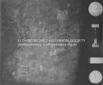
Photograph - Aerial Photograph, Landata, Eltham and Eltham North, Nov. 1931
Centred over present-day Opal Court and Manning Road, Eltham North Historic Aerial Imagery Source: Landata.vic.gov.au Aerial Photo Details: Project No :1931 Project : MALDON PRISON Run : 19 Frame : 3131 Date : 11/1931 Film Type : B/W Camera : F8 Flying Height : 11000 Scale : 18860 Film Number : 60 GDA2020 : 37°42'10"S, 145°08'07"E MGA2020 : 335621, 5825531 (55) Melways : 21 G2 (ed. 42)aerial photo, eltham, neil webster collection, eltham north, manning road, opal court -
 Eltham District Historical Society Inc
Photograph - Aerial Photograph, Landata, Eltham and Eltham East, Nov. 1931
Centred over present-day Beard Street bewteen Park Road and Main Road, Eltham East Historic Aerial Imagery Source: Landata.vic.gov.au Aerial Photo Details: Project No :1931 Project : MALDON PRISON Run : 20 Frame : 3135 Date : 11/1931 Film Type : B/W Camera : F8 Flying Height : 11000 Scale : 18860 Film Number : 60 GDA2020 : 37°42'16"S, 145°09'41"E MGA2020 : 337912, 5825386 (55) Melways : 22 B2 (ed. 42)aerial photo, eltham, neil webster collection, beard street, eltham east, main road, park road -
 Eltham District Historical Society Inc
Photograph - Aerial Photograph, Landata, Eltham, Nov. 1931
Centred over present-day Laleham Court between Arthur Street and Hartland Way, Eltham Historic Aerial Imagery Source: Landata.vic.gov.au Aerial Photo Details: Project No :1931 Project : MALDON PRISON Run : 20 Frame : 3136 Date : 11/1931 Film Type : B/W Camera : F8 Flying Height : 11000 Scale : 18860 Film Number : 60 GDA2020 : 37°42'56"S, 145°09'33"E MGA2020 : 337759, 5824139 (55) Melways : 22 B5 (ed. 42) aerial photo, eltham, neil webster collection, arthur street, hartland way, laleham court -
 Eltham District Historical Society Inc
Photograph - Aerial Photograph, Landata, Eltham, Nov. 1931
Centred over Mount Pleasant Road and Kent Hughes Road, Eltham Historic Aerial Imagery Source: Landata.vic.gov.au Aerial Photo Details: Project No :1931 Project : MALDON PRISON Run : 20 Frame : 3137 Date : 11/1931 Film Type : B/W Camera : F8 Flying Height : 11000 Scale : 18860 Film Number : 60 GDA2020 : 37°43'37"S, 145°09'26"E MGA2020 : 337606, 5822892 (55) Melways : 22 A8 (ed. 42) aerial photo, eltham, neil webster collection, kent hughes road, mount pleasant road -
 Eltham District Historical Society Inc
Photograph - Digital Photograph, Rhys Humphries, The Countess, 2023
Photo was taken on a Pentax k1000 on 35mm B&W film. And burned and dodged in the darkroom with a filter of 5 layered on filter 2. Montsalvat Youth Photography Prize 2023 The Montsalvat Youth Photography Competition 2023 was opened to young people aged 14 - 18, based in Victoria. Entrants were invited to explore the grounds, buildings, people, and activities of Montsalvat – to capture its essence and bring their own imagination to the process. First Prize: $1000 sponsored by Future Leaders The winner’s work printed and framed by Montsalvat for display in the Barn Gallery for a three-week exhibition slot. Second Prize: $500 Ten artists were shortlisted and placed on rotational display on Montsalvat’s website and screened in the Barn Gallery for a three-week digital exhibition. In sponsorship with Eltham District Historical Society, the shortlisted works were also to be catalogued and preserved, providing a permanent display of work for young photographers. KEY DATES: Entries opened: Monday the 3rd of April 2023 Entries closed: Friday 8th September - Midnight Finalists advised: Friday 15th September The winners were formally awarded their prize at Montsalvat on Sunday, October 8, 2023. The winners: • 1st place – Yirong Huang Enliven • 2nd place - Rhys Humphries, The Countess • 3rd Place- Jemimah Lavis Windowmontsalvat youth photography prize 2023, montsalvat, second place, emilion clark -
 Eltham District Historical Society Inc
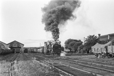
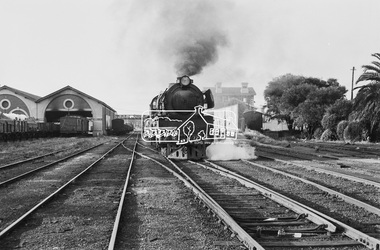
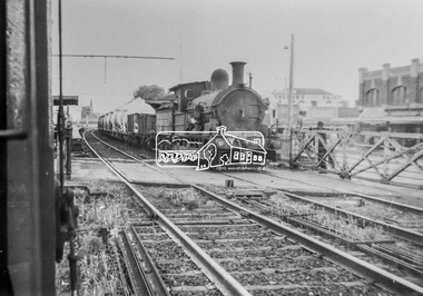
Photograph, Steam locomotive R-727 hauling goods carriages, departing Echuca Railway Station, Nov. 1963
Image dated as November 1963 based on similar image in Port of Echuca collection (frame 33 of film) (print 19.5 x 24.5cm) On reverse in blue pen:" Photo by: George L. Coop Nov 1963". In pencil : " R Class goods 1948" (circled). Crossed out, in black pen: "563a" https://victoriancollections.net.au/items/59debc6021ea6f12dcaa22adDigital TIFF file Scan of 35mm Ilford FP3 black and white negative transparencyechuca railway station, george coop collection, r-727, railway workshop, r-class steam locomotive -
 Eltham District Historical Society Inc
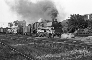
Photograph, Steam locomotive R-727 hauling goods carriages, departing Echuca Railway Station, Nov. 1963
Image dated as November 1963 based on same image in Port of Echuca collection (frame 33 of film) (print 19.5 x 24.5cm) On reverse in blue pen:" Photo by: George L. Coop Nov 1963". In pencil : " R Class goods 1948" (circled). Crossed out, in black pen: "563a" https://victoriancollections.net.au/items/59debc6021ea6f12dcaa22adDigital TIFF file Scan of 35mm Ilford FP3 black and white negative transparencyechuca railway station, george coop collection, r-727, railway workshop, r-class steam locomotive -
 Eltham District Historical Society Inc
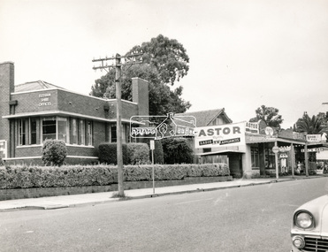
Negative - Photograph, Peter Bassett-Smith (poss), Shire of Eltham Office and Hall and adjacent shops, Main Road, Eltham, c.1961
Eltham Shire Offices 1941-1965, were located at the Corner of Arthur Street and Main Road, Eltham. The Building also incuded a community hall.Negative black and white film 120 6x6 format [Missing] One of six frames (sectioned: three continuous, two single frames and one frame missing), and Associated black and white photo printeltham, main road, arthur street, council, eltham hall, eltham shire office, shire of eltham, astor radio & tv, eltham shire council, eltham shire hall, municipal offices, shire offices, shops -
 Eltham District Historical Society Inc
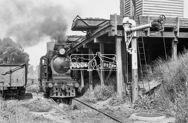
Photograph, Steam locomotive K-158 at the coal hopper, Echuca Railway Station, November 1963, 1963
THE ECHUCA COALING STAGE. Locomotives would stop alongside to receive coal dropped into their tenders from small overhead rail mounted tipping trays. Water could be obtained from either the elevated tank at one end or the connected standpipe at the opposite end. Locomotive firebox contents could be dumped into pits between the rails from locomotives once they were carefully positioned above them. Such locomotives then could move onto the Engine Shed area for overnight parking. Firebox fires would be re-lit when the locomotive was next needed in a day or so. Image dated as November 1963 based on same image in Port of Echuca collection (possibly frame 32 of film) (print 19.5 x 24.5cm) On reverse in pencil: " K Class at Echuca" Echuca K Class. 1940-1968". In blue pen:" Photo by: George L. Coop Nov 1963" https://victoriancollections.net.au/items/59de9cc421ea6b12dc3f7597Digital TIFF file Scan of 35mm Ilford FP3 black and white negative transparencycoal hopper, echuca railway station, george coop collection, k-158, k-class steam locomotive (vr newport workshops) -
 Eltham District Historical Society Inc
Photograph, Steam locomotive R-727 hauling goods carriages, departing Echuca Railway Station, November 1963, 1963
Image dated as November 1963 based on similar image in Port of Echuca collection (possibly frame 32 of film) (print 19.5 x 24.5cm) On reverse in blue pen:" Photo by: George L. Coop Nov 1963". In pencil : " R Class goods 1948" (circled). Crossed out, in black pen: "563a" https://victoriancollections.net.au/items/59debc6021ea6f12dcaa22adDigital TIFF file Scan of 35mm Ilford FP3 black and white negative transparencyechuca railway station, george coop collection, r-727, railway workshop, r-class steam locomotive -
 Eltham District Historical Society Inc
Photograph, George Coop, Copy of a photo of Steam locomotive Y-103 at Newport Railway Station, c.1951, 1962
The Melbourne Road level crossing is now the location of the pedestrian underpass. Hall Street is seen to the right and the two-storey brick building remains to present day One of several photos at Newport taken the same day in the early 1950s when George Coop was a secondary school student. This photo is a 35mm copy (1962) of an original print of the c.1951 negative - possibly to use up the last frame after photographing several other early VR prints.Digital TIFF file Scan of 35mm Ilford FP3 black and white transparencygeorge coop collection, hall street, level crossing, melbourne road, newport railway station, y-103, y-class steam locomotive -
 Eltham District Historical Society Inc
Photograph, 68 Mount Pleasant Road, Eltham, c.1983, 1983
An early Alistair Knox design and build, this home was purchased by George Coop in 1968. Eltham builder, Graham Rose, extended the original Alistair Knox structure over the foundation excavation dug by George. Graham organised the brick walls where required, raised all frame work and laid the steel tray roof. George did all external/internal wall cladding, made all opening windows, sliding and swinging doors, stairs and general interior timber cabinet work. Bedroom wardrobe doors came from scrapped Victorian Railways country coaches. This particular view shows the original Alistair Knox design and materials. The photo was taken where the original external wall was located and knocked down to add the extension.Digital TIFF file Scan of 35mm Ilford XP1 black and white transparencyalistair knox design, eltham, graham rose, houses, mount pleasant road -
 Waverley RSL Sub Branch
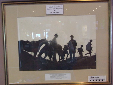
Photograph 12th Battery Field Artillary, 12th Battery Field Artillary, u/k
2nd Division Artillery Formed September 1915 and assigned to 2nd Division Subunits: 2nd Division Ammunition Column September 1915 - past November 1918 4th Field Artillery Brigade 23 September 1915 - past November 1918 10th Field Artillery Battery 11th Field Artillery Battery 12th Field Artillery Battery 104th Field Artillery (Howitzer) Battery 4th Brigade Ammunition ColumnPhotographic Print of 12th Battery Field Artillery France 1914 1918 in wooden frame under glassphoto artillery, 12 fab, raa 2nd division -
 Ballarat Clarendon College
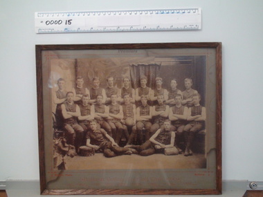
Framed photograph, Willets, Ballarat, Ballarat College Football 1890, 1890 (exact)
This photograph provides a fascinating insight into clothing and deportment in school sport in the late nineteenth century. A significant social record of clothing and deportment in school sport during the late nineteenth century. Sepia toned photograph pasted grey card mount and framed behind glass. Thin wooden frame. Photograph depicts the Ballarat College premiership football club in 1890. Players are in uniform - sleeveless, collarless shirts, knickerbockers, stockings and laced boots or shoes. There are 20 boys. The photograph is titled. 'Premiers', 'Ballarat College Football Club, 1890' and the students names are p[rinted on the mount. Printed on mount above photograph: 'Premiers' Printed below phoograph: 'Willets, Photo. Ballarat/Ballarat College Football Club, 1890/ J. Cohen, A. Greenfield, J. Cameron, A. Bregazzi, H. O'Farrell, C. Robinson, W. McCook, A. Laidlaw, W. Mockett/ F. Kersley, W. Whykes, A. McCook, M. Lynch, B. Martin, J. Rentoule, H. Bailey, H. Levein, D. Williamson/ P. Smith, E. Wanliss' Stamped on rear of framing board: 'J. A. Reynolds/Decorator and picture framer/28 Sturt St. Ballarat' ballarat college, football, 1890, uniform sports, premiership, ballarat college football club, j cohen, a greenfield, j cameron, a bregazzi, h o farrell, c robinson, w mccook, a laidlaw, w mockett, f kersley, w whykes, a mccook, m lynch, b martin, j rentoule, h bailey, h levein, d williamson, p smith, e wanliss -
 Lara RSL Sub Branch
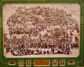
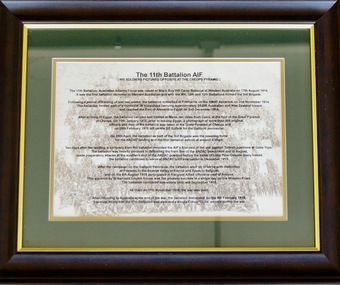
Framed Print, Original photo 28/2/1915
The 11th Battalion, Australian Infantry was raised at Blackboy Hill Camp Bellevue in Western Australia on the 17th of August 1914. Following a period of training of just 2 weeks the Battalion embarked at Fremantle on the HMAS Ascantius on the 11th of November 1918. The Ascantius formed part of a convoy 38 troop ships carrying approximately 35,000 Australians and New Zealanders and reached the port of Alexandria Egypt on the 3rd of December 1914. After arriving in Egypt, the Battalion camped and trained at Mena, ten miles from Cairo at the foot of the great pyramid Cheops. On the 10th of January 1915 prior to leaving Egypt, a photograph of more than 800 original officers and men of the battalion was undertaken at the great pyramid of Cheops on the 28th of February 1915Historical photograph of the 11th Infantry Btn taken on the Cheops Pyramid Mena Egypt on the 28/2/1914Plastic framed print behind glass with plaque medals and two rising sun badgesAnzac and plaque describing the historical significance.11 battalion aif cheop pyramid egypt photo pegan anzac mena hmas ascantius -
 Lara RSL Sub Branch
Framed collection of the Kokoda Trail, The Kodoka Trail, Circa 2018
The Kokoda Track (or Trail) is a single-file thoroughfare that runs 96 kilometres (60ml) overland) - 60 kilometres (37ml) in a straight line - through the Owen Stanley Range in Papua New Guinea (PNG).The trail was First used by Europeans in the 1890s by miners struggling northwards to the Yodda Kokoda goldfields. During the Pacific War of World War 2 a series of battles were fought from July 1942 to January 1943 between Japanese and Australian forces.One of the bloodiest campaigns of World War 2,which has forever sealed the relation ship between Australia and Papua New Guinea began 61 years ago. This Photographic Memorial is dedicated to those Australian and Papua New Guinea forces who fought against the Japanese with courage and fortitude on the Kokoda Trail.Rectangular shaped glass covered picture frame showing a collection of photos,two flags and a Rising sun badge. The Kododa Trail.kokoda track, world war 2, papua new guinea, australian forces, lara r.s.l. -
 Lara RSL Sub Branch
Picture, The 11th Battalion AIF at Cheops
Details of the famous 11 Battalion photo posing on the Cheops Pyramid at Mena 10 miles from Cairo. Also includes a brief history of the Battalion campaigns. Background watermark of the photo of troops on the pyramid. The Battalion returned to Australia at the end of war and was disbanded on 6th of February 1919. Awarded a Kings colour for its service.Famous photo of the 11th Battalion (800 men) posing on the Cheops Pyramid on the 10th of January 1915.Rectangular framed print which describes the famous photo of the 11th AIF Battalion posing on the cheops pyramid (Catalogue item 807)Printed details of the famous 11 Battalion photo posing on the Cheops Pyramid at Mena 10 miles from Cairo. Also includes a brief history of the Battalion campaigns. Background watermark of the photo of troops on the pyramid11th battalion cairo cheops blackboy hill cheops cairo egypt ypres somme -
 Lara RSL Sub Branch
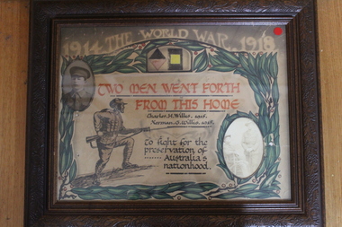
framed picture 1914-1918 Willis, Two men forth from this home - Charles H. Willis 1915 & Norman G. Willis 1915
Wooden framed World War 1 memorial - Two Men Went Forth From This Home - Charles H. Willis 1915 & Norman G. Willis 1915. To fight for the preservation of Australia's nationhood. Titled - 1914 The World War . 1918. Photo inserts of Charles H. Willis 1915 & Norman G. Willis 1915. Grey colored title band. Green wreath encircling with a stylized Australian Soldier with rifle and bayonet.Memorial for Charles H. Willis 1915 & Norman G. Willis 1915. Two men went forth from this home. -
 Lara RSL Sub Branch
Newspaper Photo, 1980's
... Laminated Newspaper Photo in wood glass frame... of plaque Nil Laminated Newspaper Photo in wood glass frame ...Dedication of plaque Laminated Newspaper Photo in wood glass frameNil -
 Lara RSL Sub Branch
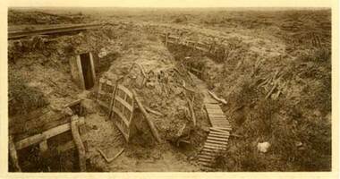
Photo of the Zonnebeke sector near Ypres in 1919 showing a trench system with dugout/tunnel entrance
Rectangular shaped glass covered picture frame showing a trench system with dugout/tunnel system entrance.ww1, ypres, flanders battlefields, lara r.s.l. belgium. -
 Lara RSL Sub Branch
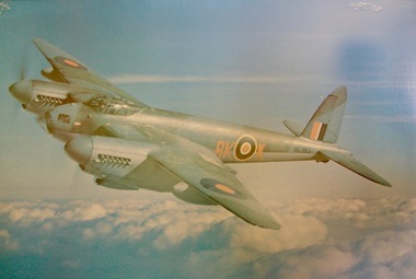
Framed photo print of Mosquito fighter plane
... Mosquito fighter plane. Framed photo print of Mosquito fighter ...The de Havilland DH.98 Mosquito is a British twin-engine shoulder-winged multi-role combat aircraft. The crew of two, pilot and navigator, sat side by side. It served during and after the Second World War. It was one of few operational front-line aircraft of the era whose frame was constructed almost entirely of wood and was nicknamed The Wooden Wonder. https://en.wikipedia.org/wiki/De_Havilland_MosquitoIt is one of the paradoxes of aircraft development that some of the world's greatest aeroplanes have achieved their fame doing jobs other than the one they were originally designed for. No better example of this could be found than the Mosquito, which, conceived as a bomber, became one of the war's most potent fighters. More than this, indeed, it was probably the most successfully versatile of any twin-engined type built between 1939 and 1945. It excelled in all the widely varied roles. Its duties included the duties of low-level and high-attack day and night bomber, long-range photo-reconnaissance, mine layer, pathfinder, high-speed military transport, long-range day and night fighter, and fighter-bomber. It served in Europe, the Middle and Far East and on the Russian front. In fact, the ubiquitous Mosquito reigned supreme among General Purpose types. Of the grand total of 7,781 Mosquitos built, 6,710 were delivered during the war years. www.aviation-history.com/dehavilland/mosquito.html Rectangular shaped picture frame showing Mosquito fighter plane.fighter planes, ww2, british aircraft, mosquito fighter planes, lara r.s.l. -
 Lara RSL Sub Branch
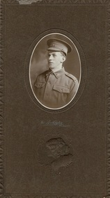
Photograph, Burlington Studios, J.L.McIntyre
The Burlington Studios were in the Wertheim Buildings, 294 Bourke Street, Melbourne (now the Bourke Street Mall). The photo would have been taken circa 1915. WW1 picture of (Jack McIntyre) J.L. McIntyre; REG. No. 3591; 58th. BATT. 1st A.I.F Foundation Member Lara R.S.L. 1890 - 1990 well documented history and service record.Carboard with wax paper over framed pictureOn front side, half way down are the words The Burlington Melbourne and below this is an embossed picture of a female upper torso. On the rear in pen are the words J.L. J.McIntyre (Jack) 45 Walkers Road Lara. -
 Lara RSL Sub Branch
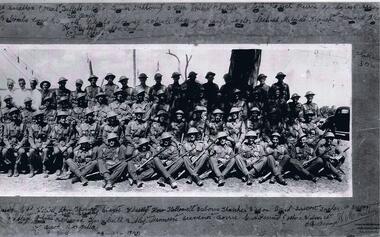
Photograph of A Company 2/21st Battalion Australian Infantry, c July to September 1940
... Photo and frame A Coy 2/21 with names inscribed.... a coy 2/21 battallion Photo and frame A Coy 2/21 with names ...Black and White photo Company "A" 2/21Rare item of historical value due to the battallion being taken prisoner by Imperial Japanese soldiers at Ambon. The Australians suffered at the hands of their captures.Photograph of members of " A" Company 2/21st Battalion Australian infantry Taken in Melbourne. Vic. Group portrait of A Company, 2/21st Battalion. Left to right: front row: Chafer, Hartley, Bailey, Fisher, Breen, Marsh, Lance Corporal (L Cpl) Billings, Smith, Knuckey, McKenzie, Wilson, Dallagh, Jones, Redwood, Turnbull, Rutley, Minetti, Gravener and Corporal Borr (?). Second row: Winter, Brander, M.F. Osborne, V.F.H. Hubbard, Gladigou, Alison, Davies, Blair, Edney, Tuddenham, B. Tucker, Sergeant (Sgt) Stanbridge, Captain (Capt) Wesley, Lieutenant (Lt) Thomas, Sgt Stayte, Beachley, Hallowell, A. Osborne, Thatcher, Watson, unidentified, Ericson, Hadlow, Tucker, McGregor, C.R. O'Bryan and Bradley. Third row: Walker, R.R. Hubbard, Hutchins, L Cpl Kirwan, Mason, J.M. Francis, Corson (?), Leslie, Dunbar, Arnold, Inkster, Balcombe, Corporal Leary, Beckwirth, Barclay, Blanks, Conway, Bolwell, Rigney, Orange, Taylor, Dihood, Mitchell, Donchi, Howard, Flintoff, Hill, Capon, Lewin, L Cpl Eouid (?), Sgt Jacobs. Fourth row: Sgt Seabrooke, Privates King, Jorgenson, O'Halloran, Simmons, Amesbury, Kofoid, Daff, L Cpl Guest, Cooke, Ordish, Stratton, three cooks named Keel, Tullett and Brown, Privates Turner, Dahlberg, Uren, Ansett, Moran, Fry, Penny, Phillips, Lock, Loch, Perrin, Snodgrass, Argus, Gee, Corp Boyce.Photo and frame A Coy 2/21 with names inscribed there on. Black ans white photo by H.M. Walker, Wentworht House, 203 Collins Street, Melbourne.a coy 2/21 battallion -
 Lara RSL Sub Branch
Photo, Lest We Forget (Ken Lewis)
Photo in memory of Ken Lewis Black metal frame, Glass fronted, wooden backedLest We Forget Ken Lewis 10/2/2013 -
 Marysville & District Historical Society
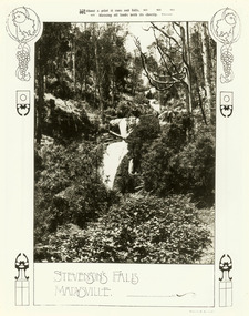
Photograph (item) - Black and white photograph, W.S. Cowper, Unknown
An early black and white photograph of Steavenson Falls in Marysville in Victoria.An early black and white photograph of Steavenson Falls in Marysville in Victoria. The Steavenson Falls are named after the Victorian Assistant Commissioner of Roads and Bridges, John Steavenson who arrived in Victoria in the early 1860s.STEVENSON'S FALLS/ MARYSVILLE. Photo by W.S. Cowperstevenson's falls, steavenson falls, marysville, victoria, waterfalls, w s cowper, john steavenson -
 Lara RSL Sub Branch
Framed photo of End of WW2 rememberance day at Lara R.S.L.1990
... glass covered picture frame Framed photo of End of WW2 ...Rectangular shaped glass covered picture frame