Showing 10948 items matching "lander"
-
 Whitehorse Historical Society Inc.
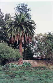
Photograph, Palm Tree - Schwerkolt Cottage, 21/04/2001 12:00:00 AM
Coloured photo of Palm Tree on original Schwerkolt Homestead land, abutting Schwerkolt Cottage Reserve.schwerkolt cottage, palm trees -
 Whitehorse Historical Society Inc.
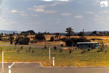
Photograph, Tally Ho Land
Coloured photo of Tally Ho Land, Corner Springvale Road and Burwood Highway before development.tally ho -
 Whitehorse Historical Society Inc.
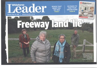
Article, Healesville Freeway Reserve Sell-off?, 2018
Chunks of land once earmarked for the now-cancelled Healesville Freeway could eventually be sold to developers.Chunks of land once earmarked for the now-cancelled Healesville Freeway could eventually be sold to developers.Chunks of land once earmarked for the now-cancelled Healesville Freeway could eventually be sold to developers.healesville freeway reservation, payne, ann, makhijani ann, friends of healesville freeway reserve -
 Whitehorse Historical Society Inc.
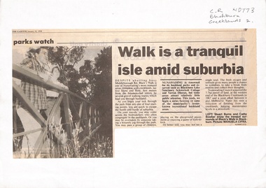
Newspaper - Article, Walk is a tranquil isle amid suburbia, 10/01/1994
Walk developed after land acquired by Nunawading Council at western end of Blackburn Creeklands in 1967.parks and reserves, city of nunawading, melbourne water, blacks walk, middleborough road, blackburn, burns, stuart, bowker, cathy -
 Whitehorse Historical Society Inc.
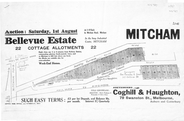
Pamphlet, Bellevue Estate, ca 1927
Land sale of 22 allotments at Mitcham ca 1927 bounded by Barkly Terrace and Church Street.land sales, barkly terrace, mitcham, church street, bellevue estate, coghill & haughton -
 Whitehorse Historical Society Inc.
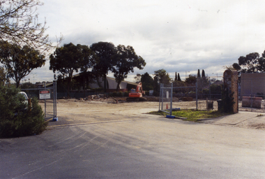
Photograph, Colombo Street Mitcham, 2006
Coloured photo of land for proposed development of a fourteen storey apartment block in Colombo Street, Mitchamcolombo street mitcham, high-rise buildings -
 Whitehorse Historical Society Inc.
Photograph, Vitclay Pipes Pty Ltd, 1995
First owners, Whites of England - hand made bricks, coffee jugs, hand made agricultural pipes and garden edgings. 1911 Commonwealth Insulator Co run by Gee Brothers - stone ginger bottles, insulators for PMG. 1920 Parker & Strangwood. Closed for a short while. 1931 Descendants of Gee Brothers. 1936 Commonwealth Art Tiles, Bricks & Pottery Works. 1961 Brick and Pipe Industries. 1971 Amalgamation leading to Vitclay.Four coloured photos ( a-d ) of the dismantling of Vitclay buildings in 1995 and subsequent vacant land for housingvitclay pipes pty ltd, pipeworks, commonwealth potteries pty ltd, clay industries, gee family, commercial insulators, brick and pipe industries, commonwealth art, tile, brick and pottery works -
 Clunes Museum
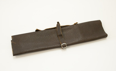
Memorabilia - LEATHER DOCUMENT HOLDER
.1 Leather satchel with buckled leather strap .2 Land title, printed on cream parchment Nil2002, leather satchel, ned kelly film -
 Bendigo Historical Society Inc.
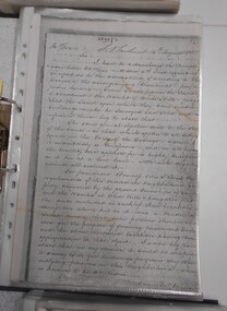
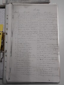
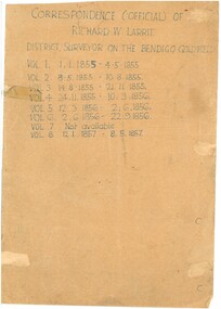
Document - RICHARD LARRITT COLLECTION: LETTERS, 1850s
Folder of Richard W. Larritt's letters/notes regarding the surveying of land in the Bendigo (Sandhurst) region.Richard Larrittperson, government, richard w. larritt -
 Wangaratta RSL Sub Branch
Photograph, c1940
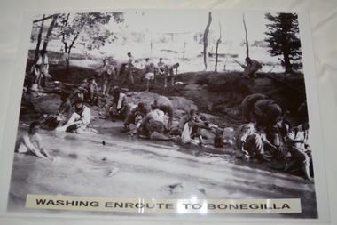
In July 1940, the 2/24th Battalion was formed in Wangaratta. On the 27th September, after weeks of hard training the Battalion marched out to Bonegilla to continue training prior to overseas deployment to the Middle East in November, 1940. This image depicts soldiers bathing and washing during the 60 mile march.The 2/24th Battalion was an infantry battalion of the Australian Army, which served during World War II .A unit of all-volunteers, it was formed in July 1940 from primarily Victorian volunteers and was known as "Wangaratta's Own" because of the time the battalion spent in the town during its formative period prior to deployment overseas. It served in North Africa in 1941–1942 as part of the 26th Brigade, which was assigned to the 7th Division, before being reassigned to the 9th Division. In early 1943, the battalion returned to Australia and later took part in campaigns against the Japanese in New Guinea in 1943–1944 and Borneo in 1945, before being disbanded in 1946. The 2/24th suffered the highest number of casualties of any 2nd AIF infantry battalion. The Unit was granted the Freedom of the City by the Rural City of Wangaratta in 1990 and one of the first, if not the first, to receive this type of honour.Reproduced black and white photograph of unknown soldiers bathing and sitting on a river bank in bush land. Washing enroute to Bonegilla2/24th battalion, wangaratta -
 Bendigo Historical Society Inc.
Document - RICHARD LARRITT COLLECTION: LETTERS, 1850s
Folder of Richard W. Larritt's letters/notes regarding the surveying of land in the Bendigo (Sandhurst) region.Richard Larrittperson, government, richard w. larritt -
 Bendigo Historical Society Inc.
Document - RICHARD LARRITT COLLECTION: LETTERS, 1850s
Folder of Richard W. Larritt's letters/notes regarding the surveying of land in the Bendigo (Sandhurst) region.Richard Larrittperson, government, richard w. larritt -
 Bendigo Historical Society Inc.
Document - RICHARD LARRITT COLLECTION: LETTERS, 1850s
Folder of Richard W. Larritt's letters/notes regarding the surveying of land in the Bendigo (Sandhurst) region. Richard Larrittperson, government, richard w. larritt -
 Canterbury History Group
Letter - Request to purchase land from the Victorian Railways, 1937 - 1939
Collection of letters and drawings between A.D.Jackson and the Victorian Railways, relating to the purchase of land 1937 - 1939canterbury, canterbury road, canterbury station, victorian railways, jackson> a.d., pharmacies, car parks -
Lakes Entrance Historical Society
Book, Hannan, Kirsty, St Johns Church, Metung, Victoria, 2005
Research, interpretation land management recommendations for St. John's Church, Metung, Victoria, by Forestec Studentreligion, land settlement -
 Wangaratta RSL Sub Branch
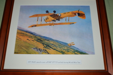
Print - Framed print
During World War II, the RAAF established twelve Elementary Flying Training Schools (EFTS) to meet the rapid demand for pilots in an expanding Air Force.Due to a shortage of pilots, observers, wireless operators and gunners, the Dominions of the Commonwealth agreed to establish a co-ordinate scheme to train 28,000 air crew each year to help England fight the war in Europe. It was known as the Empire Air Training Scheme (EATS). The Dominions would supply the trained aircrew and the mother country would provide the aircraft. Brown timber frame with cream mount containing print of two planes flying over landA17-468 cavorts over a RAAF EFTS airfield during World War Twoa17-468, raaf, ww2 -
 Lakes Entrance Historical Society
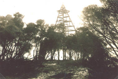
Photograph - Timber Beacon Gippsland Lakes, Vacinity of Raymond Island Victoria, 1900 c
On back of original Raymond Island Tambo River in distance. This survey lookout has been washed away, seawater has killed vegetation and allowed erosionBlack and white photograph of a timber beacon on land in Gippsland Lakes in vacinity of Raymond Island Victoriaboats and boating, navigation, waterways -
 Bendigo Historical Society Inc.
Document - H. A. & S. R. WILKINSON COLLECTION: CONTRACT OF SALE
Contract of sale of land dated 14th may, 1956 between Mr. H Nolan (vendor) and Mrs. L. J. Smith (purchaser). Property: land situate 55 Myrtle Street, Bendigo land described in Right to Occupy residence area no. 125 - Also land described in Permissive Occupancy No. W70141, together with weatherboard and rough cast dwelling and all sundry outbuildings, also blinds, curtains, electric light fittings and shades, electric sink heater, electric stovette in kitchen, galvanised iron tank and all floor coverings with the exception of the lino in the middle bedroom. Price: 3,400 pounds.organization, business, h.a. & s.r wilkinson real estate -
 Bendigo Historical Society Inc.
Document - H. A. & S. R. WILKINSON COLLECTION: CONTRACT OF SALE
Contract of sale of land dated 5th September, 1946 between Sandhurst & Northern District Trustees Executors & Agency (vendor) and Mr. E. J. Schodderlein (purchaser). Property: the surface and down to the depth of 50 feet below the surface of land being part of Crown allotment 41A section 127C, Parish of Sandhurst City of Bendigo, land described in certificate of title volume 5114 folio 122735. Also the vendor's right title and interest in the land adjoining held under occupancy No. H46884, together with all buildings and erections thereon. Subject to the existing tenancy. Price: 1,375 pounds.organization, business, h.a. & s.r wilkinson real estate -
 Kew Historical Society Inc
Plan - Subdivision Plan, Old Kew Golf Links Estate - Third Section, 1920-1929
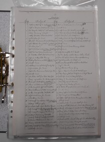
Pru Sanderson, in her groundbreaking ‘City of Kew Urban Conservation Study : Volume 2 - Development History’ (1988), summarised the periods of urban development and subdivisions of land in Kew. The periods that she identified included 1845-1880, 1880-1893, 1893-1921, 1921-1933, 1933-1943, and Post-War Development. These periods were selected as they represented periods of rapid growth or decline in urban development. An obvious starting point for Sanderson’s groupings involved population growth and the associated economic cycles. These cycles also highlighted urban expansion onto land that was predominantly rural, although in other cases it represented the decline and breakup of large estates. A number of the plans in the Kew Historical Society’s collection can also be found in other collections, such as those of the State Library of Victoria and the Boroondara Library Service. A number are however unique to the collection.The Kew Historical Society collection includes almost 100 subdivision plans pertaining to suburbs of the City of Melbourne. Most of these are of Kew, Kew East or Studley Park, although a smaller number are plans of Camberwell, Deepdene, Balwyn and Hawthorn. It is believed that the majority of the plans were gifted to the Society by persons connected with the real estate firm - J. R. Mathers and McMillan, 136 Cotham Road, Kew. The Plans in the collection are rarely in pristine form, being working plans on which the agent would write notes and record lots sold and the prices of these. The subdivision plans are historically significant examples of the growth of urban Melbourne from the beginning of the 20th Century up until the 1980s. A number of the plans are double-sided and often include a photograph on the reverse. A number of the latter are by noted photographers such as J.E. Barnes.When the old Kew Golf Links was subdivided in the mid 1920s, the developers were able to break the sale into sections. The third section included eighty lots. The lots faced Kilby Road, Kodak Avenue, Belford Road, Baker Avenue, Mathers Avenue, and White Avenue. [Kodak Avenue was renamed Page Avenue at a later date].The ‘Kew Conservation Study (1988) notes that ‘On the subdivision plan, Kodak’s involvement is commemorated by the naming of the streets after Company directors, and their decision to not proceed with the construction of the factory is explained as a response to the increase in the value of the land. This explanation may have been Estate Agent’s hyperbole, as the Kodak Company records suggest that the land, with its wide creek gully, was unsuitable and too small for its purposes.subdivision plans - kew, old kew golf links estate - third section -
 Whitehorse Historical Society Inc.
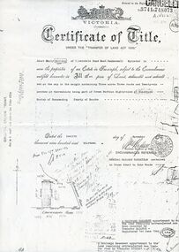
Document, Land purchase Certificate of Title, 12/11/1913 12:00:00 AM
Plan of subdivision of land in the Shire of Nunawading which includes 'Wandinong'.Plan of subdivision of land in the Shire of Nunawading which includes 'Wandinong'. Copy of Certificate of Title of Crown Grant to Janet Emily Hooke, nee Billing, dated 12/11/1913, also purchase of land by J. Woods dated 31/3/1856.Plan of subdivision of land in the Shire of Nunawading which includes 'Wandinong'. haines, william, woods, john, hooke, janet emily, billing, wandinong sanctuary, canterbury road, blackburn, blackburn road -
 Whitehorse Historical Society Inc.
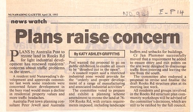
Newspaper - Article, Plans raise concern, 28/04/1993
Article in Nunawading Gazette. Plans by Australia Post to rezone land in Rooks Road to light industrial development concern residents about traffic problems. Council voted to prepare and exhibit planning scheme amendment to rezone land at 76 - 104 Rooks Road.post offices, australia post, rooks road, mitcham, no 76 - 104, jewell, peter -
University of Melbourne, Burnley Campus Archives
Booklet, The University of Melbourne, Dean's Honours and Awards Presentation, 2002-2009
dean's awards, awards, the university of melbourne, institute of land and food resources, school of land and environment -
 Bendigo Historical Society Inc.
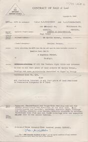
Document - H.A. & S.R. WILKINSON COLLECTION: CONDITION OF SALE
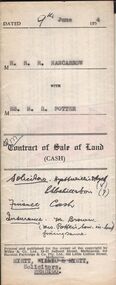
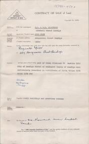
Contract of sale of land (cash) dated 9th June, 1954 between Mr. R.R. Nancarrow (seller) and Mrs M.R. Potter (buyer) for land above 50 feet below the surface and all that piece of land being part of allotment section K Parish of Sandhurst, City and County of Bendigo described in the plan at the end hereof and thereon coloured red with a frontage to Atkins Street, Bendigo. Price 1,700 pounds.organization, business, h.a. & s.r wilkinson real estate -
 Bendigo Historical Society Inc.
Slide - DIGGERS & MINING. LIFE OF THE SELECTORS, c1860
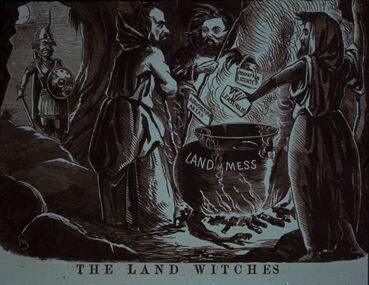
Diggers & Mining. Life Of The Selectors. Diggers & Mining. A soldier looks on as three male witches stand around a cauldron placing cards in the pot with OCCUPATION LICENSES, LEASE HOLDS and AGRICULTURAL AREAS written on them, the cauldron is labelled LAND MESS. The title of the picture is 'The Land Witches'. Markings; Life Of The Selectors 1860-1890 Set 432 No. 16. The Land Witches ''Melbourne Punch,'' Feb 25, 1864. Used as a teaching aid.Visual Eduation Centreeducation, tertiary, goldfields -
 Bendigo Historical Society Inc.
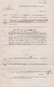
Document - H. A. & S. R. WILKINSON COLLECTION: CONTRACT OF SALE
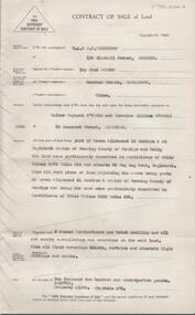
Contract of sale of land dated 13th December, 1950 between Mrs. J. Cosh (vendor) and Mr. R. Spicer (purchaser). Property: land being part of Crown allotment 3A section 161C, Parish of Sandhurst City of Bendigo, land described in certificate of title volume 8174 folio 1034639, together with all buildings and erections thereon. Price: 1,700 pounds. Attached 2 hand written notes.organization, business, h.a. & s.r wilkinson real estate -
 Bendigo Historical Society Inc.
Document - H. A. & S. R. WILKINSON COLLECTION: CONTRACT OF SALE
Contract of sale of land dated 26 March, 1956 between Mrs. I.M. Arthur (vendor) and Mr. W. R. & Mrs. V. L. O'Toole (purchaser). Property: piece of land part of Crown allotment 53 section A at Eaglehawk Parish of Nerring County of Bendigo and being land described in certificate of title volume 4870 folio 850 and situate 65 Peg Leg Road, Eaglehawk. Also all the land adjoining being part of Crown allotment 41 section A Parish of Nerring County of Bendigo land described in certificate f title volume 3198 folio 573, together with 6 room weatherboard and brick dwelling and all sundry outbuildings. Also all floor coverings, blinds, curtains and electric light fittings and shades. Price: 1,275 pounds.organization, business, h.a. & s.r wilkinson real estate -
 Federation University Historical Collection
Plan, Burrumbeep, 1884, 16/10/1884
Auctions of Crown land were introduced in the Colony of Victoria from 1851 to encourage settlers to occupy and work the land. Many squatters purchased land at auction at the upset (minimum) price of £1 per acre. In some areas where demand was high, such as the goldfields, the price realised at auction was much more. Land was put up for sale in the study area on the Burrumbeep run in May 1855, on the Lexington run in 1857, and on the Gorrinn run in 1858. (http://www.ararat.vic.gov.au/library/document/thermatics.pdf, accessed 27 January 2015) For 70 years or more, Yalla-y-Poora, Burrumbeep, Edgarley, Mount William and Narrapumelap ranked in the leading wool producers in Victoria. 1 Stud owners at Yalla-y-Poora, Eurambeen, Burrumbeep and Challicum crossed merino sheep with sheep descended from John Macarthur's Camden Park in New South Wales. (http://www.ararat.vic.gov.au/library/document/thermatics.pdf, accessed 27 January 2015) In what was to become the Ararat Mining Division, gold was discovered in May 1854 on the Burrumbeep run at a place that became known as Pinky Point on the Mount William goldfield. By 21 June 1854, between 600 and 1,000 people had arrived. (http://www.ararat.vic.gov.au/library/document/thermatics.pdf, accessed 27 January 2015)\ Town allotment plan for Burrumbeep. Merrymbuela, Borung, Lexington and Langi Logan are neighbouring areas. The plan includes the Burrumbeep Pre-Emptive Right (Roger and Wright); licensed land holders including Stephen Young, John Carroll, William Walsh, Thomas Purcell, Martha M. Bond, Colin Johnson, John Charles Webb, Henry Withycombe, William Henry Barbridge, John Wall, Thomas Flatelly, William Jenkinson, Elisia Radford, V. Radford, Denis Byrne, George Cook. Land holders included Andrew Maloney, Richard Wingfield Harrocks, W. Sporton, Terence Lynch, F. S. Falkiner, A. Millman, H. Morris, George Upham, J. McCLure, S. Fletcher, W. Parker, Thomas Myers, William wright, W.C. Winter, C. Wordman, Oliver A. Winter This plan is associated with former Ballarat School of Mines student Richard Squire (1875-6) Gift of the Squire FamilyVerso written in pencil - Plan of Burrembeep Ararat Burrembeep Araratburrumbeep, corrinn, langi logan, merrymbuela, lexington, ararat, roger & wright, cook, rogers, upham, george upham, ross, parsans, morris, johnson, withycoombe, colin johnson, falkiner, dsporton, john carroll, donald gordon, denis bryne, maurice dooley, martha bond, william harricks, \william wingfield harricks, william l.c. harricks, michael houlihan, thomas purcell, martin ryan, michael cody, fletcher, mccaw, w. parker, j.m. clow, elisia radford, thomas radford, thomas myers, barbridge, e. wilde, j. wall, flatelly, g. wardman, w.c. winter, david ball, jenkinson, ballarat school of mines, richard squire, squire -
 Orbost & District Historical Society
plan, before 1948
Drainage infrastructure was developed and maintained in this region by the Snowy River Improvement Trust. The Trust was administered by a local committee and its activities funded by a local rate charged on the farmers and land owners in the Trust’s designated district. The level of the rate charged by the Trust was designed to be proportionate to the benefit derived from the works undertaken. Financial assistance was provided by the State Government from time to time for specific projects such as post flood repairs but not for new capital works. The Trust undertook new drainage and river management works including tree planting, rock beach construction and servicing of the drains and flood gates. The Trust also provided a personal flood warning service to the farmers in its district. The Trust ceased to operate in 1997 with the advent of the East Gippsland Catchment Management Authority. The infrastructure developed by the Trust continues to provide a service to the farmers in the region. (ref. 4 East Gippsland CMA Submission to Inquiry into Flood Mitigation Infrastructure in Victoria) This plan is significant as a historical document. The Snowy River Improvement Trust was vital to the Orbost district because of its ability to apply local knowledge and to engage the local farming community.A large plan of divisions of land for the purpose of levying the Snowy River Improvement District - Bete Bolong, Orbost, Waygara, Newmerella and Orbost East. The properties are coloured according to levy amount. The scale is 1" - 20 chains. snowy-river-improvement-trust -
 Kew Historical Society Inc
Photograph - Flooding of the Yarra Valley at Kew East, 1974
Flooding of the Yarra Valley, including that section of the Yarra bordering Kew and Kew East in the north and west of the municipality, was a regular occurrence. Extreme flood events of the Yarra River are recorded to have occurred in 1891, 1901, 1916, 1923 and 1934. The Municipality of Kew's response to these floods was to enact planning decisions restricting residential development in flood prone areas following the floods of 1916, 1921 and 1934. While floods continued after the development of the Upper Yarra Reservoir (construction 1948-57), the regularity and extent of these inundations diminished. During the nineteenth century, the land abutting the south side of the Yarra in Kew was devoted to dairy farming. In the twentieth century, before and after the construction of the Eastern Freeway, much of this low-lying area was used as golf courses and public parks.Late example of the capacity of the Yarra Valley at Kew to flood, even though drainage works and the Upper Yarra Reservoir had reduced their regularity.Original black and white print photograph of the low-lying land at East Kew under floodwater on 16 May 1974. The vantage point of the photographer is Lister Street. Flooding was caused by overflowing water in Glass' Creek and the River Yarra. Annotation verso: "Lister Street looking north / Flood level / 16 May 1974 11.30am / R.L. 46.04"hays paddock, floods, yarra river, glass' creek, lister street