Showing 756 items
matching line drawings
-
 Bendigo Historical Society Inc.
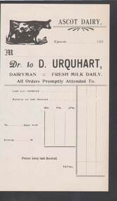
Document - CAMBRIDGE PRESS COLLECTION: ACCOUNT - ASCOT DAIRY
Account slip for Ascot Dairy, Epsom. Date line ending 193-. Beside the dairy name at the top of page is a drawing of a lady sitting on a stool and milking a cow. Account has space for Last a/c rendered, Balance on last Account,no of days milk, quarts, pints, half pints. Printed in black.business, printers, cambridge press, cambridge press collection, ascot dairy, d urquhart -
 Bendigo Historical Society Inc.
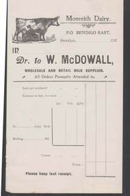
Document - CAMBRIDGE PRESS COLLECTION: ACCOUNT - MONREITH DAIRY
Account slip for Monreith Dairy, P.O Bendigo East. Date line ending 192-. Beside the dairy name at the top of page is a drawing of a lady sitting on a stool and milking a cow. Account has space for Last a/c rendered, Balance on last Account,no of days milk, quarts, pints, half pints and cream. Printed in black.business, printers, cambridge press, cambridge press collection, monreith dairy, w mcdowall -
 Bendigo Historical Society Inc.
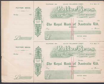
Document - CAMBRIDGE PRESS COLLECTION: CHEQUES - POTTER BROS
Sheet of two cheques with cheque butts. Printed at the top is Potter Bros. I & G Hall, Proprietors, Wholesale Fruit Merchants and Commission Agents. Around this area are drawings of fruit and vegetables. The Royal Bank of Australia Ltd. Bendigo is printed in the centre. On the left is a decorative area with Potter Bros. in the centre. Date line ends in 192-. Printed in green with red Not Negotiable across the centre.business, printers, cambridge press, cambridge press collection, potter bros, i & g hall, the royal bank of australia ltd, cambridge press -
 Bendigo Historical Society Inc.
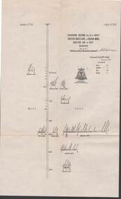
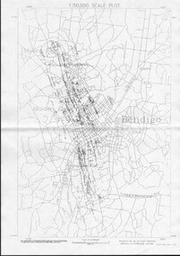
Map - STRUGNELL COLLECTION: UNITED HUSTLER'S & REDAN MINE, September 1913
Map, Transverse Sections N. & S. Of shaft, United Hustler's & Redan Mine, Hustler's Line of Reef, Bendigo. Plate No. XXX (30).Bulletin No 33 Signed H.A.Whitelaw. Drawing shows the vertical shaft descending to over 976 feet and appears to show samples of connecting horizontal shafts with their respective mineral contentsUnderground Survey Office, Bendigo.map, bendigo, hustler's & redan mine -
 Bendigo Historical Society Inc.
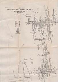
Map - STRUGNELL COLLECTION: UNITED HUSTLER'S & REDAN & K.K.MINES, September 1913
Map, Hustler's Line of Reefs, United Hustler's & Redan & K.K.Mines, Bendigo. Plate No. XXV111 (28),Bulletin 33.Signed H.A.Whitelaw. Drawing seems with their respective mineral contentsUnderground Survey Officemap, bendigo, united hustler's, redan, k.k.mines -
 Bendigo Historical Society Inc.
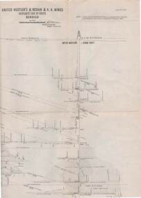
Map - STRUGNELL COLLECTION: UNITED HUSTLER'S & REDAN & K.K.MINES, September,1913
Map, United Hustler's & Redan & K.K.Mines, Hustler's Line of Reefs, Bendigo.Plat No.XXX1(31),. NOTE:- Plates 4,8,13,20,26,& 31 form a Longitudinal Section from Fortuna Hustler's to Hystler's Consols Mine. Bulletin 33.Signed H.A.Whitelaw. Drawing shows the vertical shafts descending to over 1932 feet and 1805 feet respectively .Underground Survey Office, Bendigo.map, bendigo, united hustler's, redan, k.k.mines -
 Bendigo Historical Society Inc.
Map - STRUGNELL COLLECTION: HUSTLER'S LINE OF REEFS K.K.MINE, September 1913
Map, Hustler's Line of Reefs, K.K.Mine,Transverse section.Plate No.XXX11(32).Geological Survey of Victoria.Bulletin 33.Signed H.A.Whitelaw. Drawing shows the vertical shaft descending to over 1932 feet and appears to show samples of connecting horizontal shafts with their respective mineral contents and dotted lines appear to show connecting reefs .Underground Survey Office, Bendigo,map, bendigo, k.k.mine -
 Bendigo Historical Society Inc.
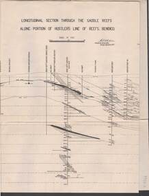
Map - STRUGNELL COLLECTION: HUSTLER'S LINE OF REEF, September 1913
Map, Longitudinal section through the Saddle Reefs along portion of Hustler's Line of Reefs, Bendigo. Plate No. XXX1V(34). Underground Survey Office,Bendigo, September 1913. Geological Society of Victoria.//Signed H.A.Whitelaw. Drawing shows the vertical shaft descending to over 3454 ftUnderground Survey Office, Bendigomap, bendigo, hustler's line of reefs -
 Port Melbourne Historical & Preservation Society
Plan - Proposed footbridge over the Lagoon, Bridge Street, Port Melbourne, 1863
Plan of proposed footbridge over the Lagoon in line of Bridge StreetIn ink on reverse, two small drawings: elevation land view over a distance of 25.00 chains (colour tinted), and Plan view, section of an unidentified street:In pencil on reverse, notation '107 Albert Street'sandridge lagoon, robert h morgan -
 Bendigo Historical Society Inc.
Document - VICTORIA HILL - VICTORIA HILL, NEW CHUM LINE LEASES
Drawing of leases with lease numbers, names of owners and names of mines on the New Chum Line of Reef. Lease numbers are: L296, L1505, L5394, L7486, 130, L1286, L3941, L6299, L7427, L323, L3175, L812, L3757, L3888, L6198, L703, L1130, L703, L3321, L3347, L3884, L4167, L4357, L6296, L55, L239, L962, L1494, L1708, L239, L962, L3320, L4779, L6457, L129, L961, L3926, L5566, L19, L959, L4652, L4895, L5371, L7740, L960, L4415, L4793.document, gold, victoria hill, victoria hill, victoria hill new chum line leases, j wybrants, s h mcgowan, north old chum n l, c & t ballerstedt, ballerstedt & son, geo lansell, j holmes, victoria reef company, h hawkins, victoria reef quartz mining co n l, g n craig, j g wheadon, wells & gibbs, midway co, s g cole, gibbs ballerstedt & wells united mining co, w barker, humboldt g m co, great central victoria co n l, howard and neumann, endeavor qtz mining co, woodward & gibbs, endeavor co, smith horner white and tipping, albert co, h birch, victoria consols mining co, victoria reef, sullivan jackson, nicholas ballerstedt & jones, ironbark quartz mining co, j h abbott, ironbark co n l, h y north, new chum consolidated g m co, d macdougall, h von der heyde, hercules & energetic co n l -
 Victorian Interpretive Projects Inc.
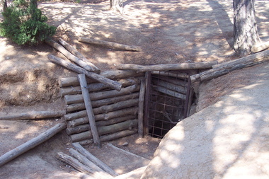
Photograph - Colour, Gaida Stevens, World War One Tunnel Entrance, Lone Pine, Gallipoli, 2015, 2015
Lone Pine was an action that featured one of the most famous assaults of the Gallipoli campaign. The attack was planned as a diversion for the Australian and New Zealand units that were to breakout from the Anzac perimeter by capturing the heights of Chunuk Bair and Hill 971. At 5.30 pm on 6 August 1915, the Australian artillery barrage lifted and from concealed trenches in no man’s land the 1st Australian Brigade charged towards the Turkish trenches. The troops paused on reaching the Turkish trenches, finding that many were covered by timber roofs. Some fired, bombed and bayoneted from above, some found their way inside and others ran on past to the open communications and support trenches behind. Others advanced as far as "the Cup" which was where Turkish support units were located and from where the Turks counter-attacked. By nightfall, most of the enemy front line was in Australian hands and outposts had been established in former Turkish communication trenches. The Australian Engineers dug a safe passage across no man’s land so that reinforcements could enter the captured positions without being exposed to Turkish fire. Having captured the Turkish trenches, the Australians now tried to hold what they had taken while the Turks desperately and determinedly tried to throw the Australians out. From nightfall on 6 August until the night of 9 August a fierce battle ensued underground in the complex maze of Turkish tunnels. The Australians succeeded in drawing the whole of the immediate Turkish reserve. Six Australian battalions suffered nearly 2,300 killed and wounded at Lone Pine. Seven Australians were awarded the Victoria Cross, the highest number ever awarded to an Australian division for one action.(http://www.awmlondon.gov.au/battles/lone-pine)Entrance to a tunnel at Lone Pine, Gallipoli. gallipoli, world war one, tunnel, mmm -
Clunes Museum
Work on paper - ENID STEART
.1 WHITE HANDMADE NAME TAGWITH PINK RIBBON AND SAFETY PIN, BLACK DRAWING OF A MAGPIE SITTING ON A POWER LINE - MRS MAGPIE WRITTEN ON THE BOTTOM OF THE CARD. .2 GIRL GUIDES ASSOCIATION OF AUSTRALIA COMMISSIONER'S WARRANT FOR MISS ENID STEART 27/11/1984 .3 WARRANT ENDORSMENT RECORD OF TRAINING DAY 1 ENID STEART 28/2/1988 .4 AUSTRALIAN BOY SCOUTS ASS. WARRANT CERTIFICATE FOR ENID STEART APPOINTED AS A SCOUTER DETAILS OF TRAINING COURSE FOR NEW SCOUTERS, CERTIFICATE CARDS FOR TRAINING COURSES 1964; 4/4/65; 3/4/65; 30/7/64 .5AUSTRALIAN BOY SCOUTS ASSOCIATION, VIC-BRANCH - WARRANT CERTIFICATE FOR MISS ENID E STEART SIGNED BY CHIEF COMMISSIONERO OF VICTORIA AND CHIEF SCOUT OF VICTORIA. ON THE BACK: WARRANT NO A 4229 SIGNED BY E E STEART 1/10/64.2 ON BACK: ENDORSED: JOAN HARTLEY 11 JUNE 87/ WARRENT CANCELLED 19/4/90clunes girl guides, enid steart, boy scouts -
Clunes Museum
Plan, CLUNES WATER SUPPLY
DRAWINGS MADE TO SET UP A PERMENT PIPED WATER SUPPLY TO NEW NORTH MINE, CLUNES, VICTORIA, AUSTRALIA1 PAGE PLAN WITH DRAWING OF CLUNES WATER SUPPLY ON WAXED PAPER USING RED, BLACK AND BLUE INKCLUNES WATER SUPPLY LONGITUDINAL SECTION OF CENTRE LINE OF THE LOWER AWUEDECT FROM WEIR A TO SERVICE RESERVOIR DRAWING 420 5 CONTRACT NO. 740 2 HORIZONTAL SCALE FOUR CHAINS TO AN INCH VERTICAL SCALE FORTY FEED TO AN INCH SIGNED BY OCTAVIUS LANGTREE WORKS ENGINEER 13/12/1870octavius langtree, peter lalor, clunes water supply -
 Wangaratta RSL Sub Branch
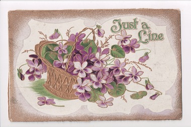
Postcard, 1917
... a line" Postcard with a drawing of a gold basket full of purple ...From the album of WWI soldier William West (1268) of the 29 Infantry Battalion, 5th Pioneers Battalion. This collection of postcards, photographs and clippings were sent between William and his family and loved ones during the years he was on active service. See also 207 and 220. Postcard with a drawing of a gold basket full of purple flowers. Newspaper cutting adhered to the back.Front: "Just a line"album, photo album, newspaper clippings, postcard, wwi, flowers, basket, gold, purple -
 Nillumbik Shire Council
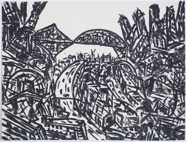
Print (sugarlift etching): Jan SENBERGS (b.1939 Lativia, arrived AUS 1950), Jan Sensbergs, 'New Jersey - rust belt' from the 'Baldessin & Friends' commemorative folio, 2016
Jan Senbergs was born in Riga, Latvia, in 1939 and came to Australia when he was ten. Senbergs’ work has been characterised by a simple and bold aesthetic. From lush landscapes to barren urban spaces, his body of work signifies an artist who has continually experimented with shape, form and motif, a fundamental humanist vision, a finely-honed sense of the absurd, and a rigorous studio practice spanning printmaking, drawing and painting. Senbergs is Baldessin's exact contemporary. He was also born in Europe and fled his homeland because of the war, arriving in Melbourne in 1950. Like George, Senbergs also worked at the RMIT and in 1973 represented Australia at the Bienal de Sao Paulo. Senbergs first met George when he was living in St. Kilda. George asked if he could screen print his 'Argus' catalogue for a show at the gallery in the Argus building. George Baldessin (1939-1978) was born in San Biagio di Callalta, in the Veneto in Northern Italy and arrived in Australia ten years later. A printmaker and sculptor he built his bluestone studio at St Andrews (Nillumbik) in 1971. The bluestone studio was hand built by George, his partner Tess and the three Hails brothers, Rob, Doug and Don. Made of recycled materials the studio today contains all of George’s equipment including the large press, which he modelled himself with the help of Neil Jeffrey (Enjay Presses). George won many prizes throughout his career and is represented in many of Australia's public art collections including his famous 'Pears' sculpture in front of the National Gallery of Australia, Canberra. In 1975 he represented Australia in the Sao Paulo Biennale, before living and working in Paris until his return to St Andrews in 1977. In 1978 George was killed in a car accident aged 39 years. In 2001 Tess returned to St Andrews to reclaim the run-down studio and reconstitute it as The Baldessin Press & Studio - a printmaking retreat. It operates in George’s memory, so that artists may continue to create, perpetuating the generous spirit of George.'New Jersey - rust belt' is one of eight prints in the 'Baldessin & Friends commemorative folio. The folio was conceived by Tess Edwards as a fundraising initiative in celebration of the The Baldessin Press & Studio's fifteen year anniversary, and as a way to honour George Baldessin's memory. The Baldessin Press & Studio is a not-for-profit organisation created in memory of the late George Baldessin (1939-1978), whose original studio is now open to the public for creative use and as a practical legacy to living artists. The Studio is located in St Andrews, Nillumbik. The folio is a unique coming together of seven very different and acclaimed artists who are connected by their friendship to the missing eighth member, George Baldessin. This print finds its' origins in the time Senbergs spent at Harvard in America in 1989-90. In the context of Baldessin it explores an industrial urban surreal vision that was common to both artist. The image captures the life force of the city revealing the keen and observant eye of Jan Senbergs. Similar in sensibility to his large scale charcoal drawings of the 1990s, the artwork is not only a record of what the artist sees, but of what interest him. By following the movement of each line the viewer can witness the artist's eye travelling through, over and around each element of the urban landscape. The scale is deceptive with the image bled to the full-size of the sheet of paper like a microcosm of a much bigger whole. sugar lift etching of an urban (cityscape - New Jersey) scene - bridges, roads, buildings, in thick black brushstrokes. The image is busy; full of energy and movement. A bleed print in which the paper barely contains the city scape. In pencil (handwritten): top centre: left '14/25' (edition); centre 'New Jersey-Rustbelt' (title); right 'Jan Senbergs' (signature); print, sugarlift etching, urban landscape, ekphrasis2018, new jersey, line, rust belt -
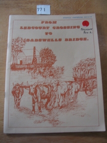 Stawell Historical Society Inc
Book, Peter Davie, From Ledcourt Crossing to Dadswells Bridge, 1980
History of Dadwells bridge area. Written for the Back-To-School. 75th Anniversary Different families of the district contributed articles & Photographs Fawn Card cover with brown print and drawing of a house with a bullock wagon in front. surround by a single line borderFrom Ledcourt crossing to Dadswell Bridgestawell -
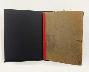 National Wool Museum
Book - Fabric Sample Book, c.1920
A Textile Designer’s Fabric Sample Book is an important tool for keeping a record of past designs. This is useful in order to showcase a designer’s previous work; functioning like a portfolio or a résumé. They also serve as a source of inspiration, sometimes even providing a template to re-release iconic designs. The National Wool Museum has a large collection of Fabric Sample Books. They reveal the colour and daring designs produced by textile mills across various time periods. This Fabric Sample Book is from the 1920s and gives us insights into design trends that are now over a century old.The cover of this book has a brown/grey marble. It carries many marks and oils from the hands, after more than a century of use. A strip of red tape has been added to the spine of the book in order to give it integrity. The book internally has white pages that have turned a brown/cream with age. These pages have a faint blue line printed horizontally across them, to assist with handwriting. The contents of the pages are fabric samples which have been staple to them, as well as handwriting with a blue ink. The pages also include technical drawings, relating to the fabric samples and how such samples were woven together.textile design, textile manufacture -
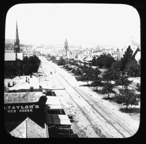 City of Ballarat Libraries
Glass Slide, Sturt St looking east from City Fire Brigade tower
Tram tracks can be clearly seen in this image. Horse trams were introduced late in 1887, the line up Sturt St to the Lake and Gardens being built first. Note these tracks do not have any electricity above them - electric trams did not appear until 1905. St Andrews Kirk steeple was erected in 1884.Previously unknown image of Ballarat. The set and its subjects indicate these images were produced to promote Ballarat and were perhaps aimed at tourists.An image repeating von Guerard's famous drawing from the City Fire Brigade tower, looking east along Sturt St to Mt Warrenheip. -
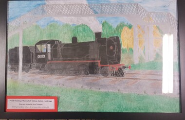 Numurkah & District Historical Society
Pencil Drawing of Numurkah Railway Station & Walkbridge
Harry Thompson's grandfather worked on the Cobram to Numurkah rail line. Pencil Drawing of Numurkah Railway Station and Walkbridge.. Artist: Harry Thompson harry thompson, railway, numurkah, station, walkbridge, footbridge -
 Ballarat Tramway Museum
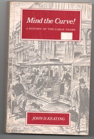
Book, John D Keating, "Mind the Curve", "Hold tight for the Curves", 1970
.1 - Hard bound book, 172 pages, including end covers, 10 sections, title "Mind the Curve", with subtitle "A history of the Cable Trams", stitch bound to hard red Rexene covers with gold block title on the spine only. Dust cover has the title, author, drawing of Bourke St and details of the book and author on the returns. Written by John D Keating, published by the Melbourne University Press in 1970. Has index, acknowledgements, table of contents, list of illustrations and references Looks at the establishment, construction, operation and demise of the cable tram system in Melbourne. Provides location details of the engines houses, tramcars, ticketing, management, politics, the Northcote line and the workers. Has a hand written note written by the daughter of John Caddell, a cable Tammie. On the page opposite the Acknowledgements is a typed note regarding visiting Mr Twentymen's house. .2 on the inside of the rear cover is a photograph and note regarding John Caddell and information about John's retirement from Preston Depot. .3 - Newspaper cutting, "Hold tight for the curves" - The Herald, 15/10/1970 - written by Laurie Power. reviewing the book. Has been adhered to a sheet of A4 white paper.trams, tramways, melbourne, mmtb, cable trams, mto co, horse trams, preston depot -
 Ballarat Tramway Museum
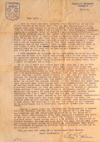
Letter - from Peter Boehm Dusseldorf to Wal Jack, Peter Boehm, 1950
Wal Jack had an extensive range of correspondents throughout Australia and the world who often provided him with detailed drawings and notes on various tramway systems. The letter from a resident of Dusseldorf West Germany, details the author's travels, issues post World War 2, photos, enlargers, a visit to Koln or Cologne, war damage, photos of Russian tramcars, tramcars in use, the interurban line to Bonn and his forthcoming visit to "Dusseldor fer Waggonfabrik" which became the Duewag factory. A web search shows that the author published at least one book on trams.Demonstrates some of the correspondence that Wal Jack received from around the world.Letter typed on A4 paper with sender's stamp and address with a pencil sketch on the rear. letters, wal jack, railways, tramways, dusseldorf, duewag, koln, colongne -
 Ballarat Tramway Museum
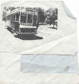
Drawing - Illustration/s, Printed on an envelope Ballarat 14, 1980's?
Demonstrates illustrating an envelope with a image of a tram. Source not known.Illustration on part of a lined window envelope of Ballarat Tram 14 at the Wendouree Parade Gardens crossing loop. Tram has the destination of Sturt St West. Appears to have been photocopied onto the envelope. Purpose not known.trams, tramways, envelopes, wendouree parade, gardens loop -
 Ballarat Tramway Museum
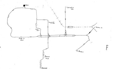
Map, Ballarat and Bendigo tram systems, 1960's or 1970's
Yields information about the extent of the Ballarat and Bendigo tramway systems and possibly has a strong association with the work of Tom Murray.Set of two hand drawn maps of the Ballarat and Bendigo tram systems, showing loops, terminus, depots and rail lines, including out of use loops and reserved track. Possibly made during the 1960's or early 1970's. Drawn on lined foolscap paper - have been torn from a pad.trams, tramways, map, drawings, ballarat, bendigo -
Moorabbin Air Museum
Document (Item) - De Havilland DH2 aircraft line drawing (Photocopy)
... De Havilland DH2 aircraft line drawing (Photocopy)... Moorabbin melbourne Document De Havilland DH2 aircraft line drawing ... -
Moorabbin Air Museum
Document (Item) - De Havilland DH6 aircraft story with line drawing (Photocopy)
... De Havilland DH6 aircraft story with line drawing... with line drawing (Photocopy) ... -
Moorabbin Air Museum
Document (Item) - Airco DH5 aircraft story with line drawing (Photocopy)
... Airco DH5 aircraft story with line drawing (Photocopy)... Moorabbin melbourne Document Airco DH5 aircraft story with line ... -
Moorabbin Air Museum
Document (Item) - AESL AirTourer 115 and Super 150 AirCruiser 210 aircraft and Victa story with line drawing (Photocopy)
... and Victa story with line drawing (Photocopy)... AirCruiser 210 aircraft and Victa story with line drawing (Photocopy) ... -
Moorabbin Air Museum
Document (Item) - RAAF Sidewinder Guided Missile stories with line drawing (Photocopy)
... RAAF Sidewinder Guided Missile stories with line drawing... with line drawing (Photocopy) ... -
Moorabbin Air Museum
Document (Item) - Bloodhound missile story with line drawing (Photocopy)
... Bloodhound missile story with line drawing (Photocopy)... Moorabbin melbourne Document Bloodhound missile story with line ... -
Moorabbin Air Museum
Document (Item) - Lockheed P3 Orion story with line drawing (Photocopies)
... Lockheed P3 Orion story with line drawing (Photocopies)... Moorabbin melbourne Document Lockheed P3 Orion story with line ...