Showing 1067 items matching "over the river"
-
 Greensborough Historical Society
Newsletter, Plenty Gorge Metropolitan Park Newsheet No. 1 August 1989, 1989_08
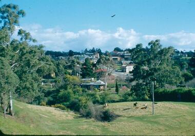
The Shire of Whittlesea obtained a grant from the federal government to investigate the potential development of a park to the west of the Plenty River in 1976. A regional tip site and the Shire of Diamond Valley's Yarrambat Park were handed over to the MMBW to form the existing Metropolitan Park in 1986. A long term project to develop the park further is to commence in 1990.2 p. text, map and col. illus."With compliments of Sherryl Garbutt M.P. Member for Greensborough" (rubber stamp)plenty gorge park -
 Greensborough Historical Society
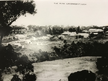
Photograph, The Park Greensborough, 1900c
View of Greensborough Park from Partington's Hill, showing sporting ground, Plenty River, Marble Hall, sparse housing on north side of Main Road, the Farmers' Arms hotel, the Rechabite Hall and Main Road bridge over the the railway line. Marble Hall is the double-storied building on the corner of Main Road.Part of a collection of 5 enlarged photographs dating from the early 1900s.Black and white enlargement of photographgreensborough park, main street greensborough, rechabite hall, farmers' arms hotel, marble hall, greensborough railway -
![Photograph - Digital image, 24 River Street [Briar Hill], 02/05/2013](/media/collectors/4f729f5697f83e03086015b8/items/572868fc2162f115acc626a5/item-media/572869462162f115acc630d2/item-fit-380x285.jpg) Greensborough Historical Society
Greensborough Historical SocietyPhotograph - Digital image, 24 River Street [Briar Hill], 02/05/2013
This photograph of 24 River Street was taken in 2013 to show changes over 40 years, based on Ron Reynold’s sketches in the 1973 publication “Greensborough and Greenhills” published by Cypress Books.Digital copy of colour photograph.greensborough and greenhills, river street briar hill, ron reynolds -
![Photograph - Digital image, House St Helena and Diamond Creek Roads [Greensborough], 02/05/2013](/media/collectors/4f729f5697f83e03086015b8/items/5729bbd22162f108e8de5be2/item-media/5729bc112162f108e8de617d/item-fit-380x285.jpg) Greensborough Historical Society
Greensborough Historical SocietyPhotograph - Digital image, House St Helena and Diamond Creek Roads [Greensborough], 02/05/2013
These photographs of the house on the corner of St Helena and Diamond Creek Roads was taken in 2013 to show changes over 40 years, based on Ron Reynold's sketches in the 1973 publication 'Greensborough and Greenhills' published by Cypress Books... which states "Built on a steep hill in a bush setting in the early 1920s, for a Dr Wood, the weatherboard house now overlooks an area of activity and change. The owners, Mr and Mrs E. 'Bluey' Blackburn, remember when their 3/4 acre building block dropped to the edge of a dirt road. Today the view from the high verandah encompasses the Main Street shopping centre, new and old bridges, new roads and houses, the Plenty River, natural bush, hills and sports grounds."Digital copy of colour photograph.greensborough and greenhills, st helena road greensborough, diamond creek road greensborough, wood family, ron reynolds -
![Photograph - Digital image, Old Plenty River Swimming Pool [Greensborough], 02/05/2013](/media/collectors/4f729f5697f83e03086015b8/items/5729bfe02162f108e8de938c/item-media/5729c0092162f108e8de9a06/item-fit-380x285.jpg) Greensborough Historical Society
Greensborough Historical SocietyPhotograph - Digital image, Old Plenty River Swimming Pool [Greensborough], 02/05/2013
These photographs of the old swimming pool in the Plenty River were taken in 2013 to show changes over 40 years, based on Ron Reynold’s sketches in the 1973 publication “Greensborough and Greenhills” published by Cypress Books. Digital copy of 3 colour photographs.greensborough and greenhills, plenty river swimming pool, ron reynolds -
 Greensborough Historical Society
Photograph - Digital image, Frank Robinson, Looking west over Pope's paddock to Main Street, 1954_
Looking west over Pope's paddock to Main Street. The Blackjack property, house and acres of fruit orchards ran down to the Plenty River off Hume Street Greensborough and was the home of the Robinson family to late 1956. The photographs were taken as slides by Frank Robinson and digitised by his son James in 2015.Digital copy of colour photograph.popes paddock, main street greensborough, blackjack -
 Greensborough Historical Society
Photographs, Photographs by Maria Barbaro, 2009_
A collection of over 170 photographs taken by artist Maria Barbaro as studies for her paintings. Taken in the Greensborough area, photos cover a wide range of natural and built landscapes, including the Plenty River; parks and gardens; the Greensborough Hotel; Ashmead; Greensborough railway station.A variety of photographs of the Greensborough area in the early 21st Century.Folder containing approx 150 colour photographs of Greensborough area. Each photograph 10x15cmmaria barbaro, greensborough -
 Greensborough Historical Society
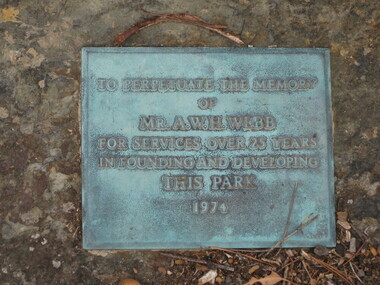
Photograph - Digital image, Dennis Ward, Plaque - A. H. W. Webb, 27/03/2010
Plaque on Plenty River Trail at Greensborough: "To perpetuate the memory of Mr A. H. W. Webb for services over 25 years in founding and developing this park".Sign from the early development days of the Plenty River Trail.Digital copy of colour photographs.plenty river trail, a h w webb -
 Greensborough Historical Society
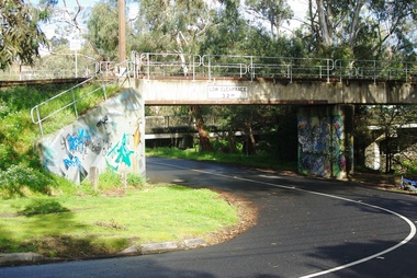
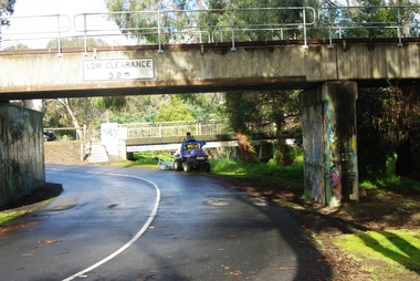
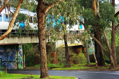
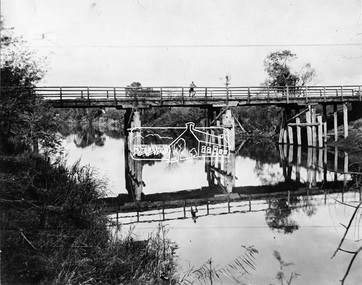
Photograph - Digital image, Marilyn Smith, Railway Road Rail Bridge over Plenty River Briar Hill, 17/09/2014
... Railway Road Rail Bridge over Plenty River Briar Hill... over Plenty River Briar Hill Photograph - Digital image Marilyn ...Rail bridge over Railway Road Greensborough, near Para Road.Digital copy of colour photographrailway road greensborough, para road greensborough -
 Greensborough Historical Society
Photograph - Digital image, Marilyn Smith, Railway Road Rail Bridge over Plenty River Briar Hill, 17/09/2014
... Railway Road Rail Bridge over Plenty River Briar Hill... Bridge over Plenty River Briar Hill Photograph - Digital image ...Rail bridge over Railway Road Greensborough.Digital copy of colour photograph -
 Greensborough Historical Society
Photograph - Digital image, Marilyn Smith, Railway Road Rail Bridge over Plenty River Briar Hill, 17/09/2014
... Railway Road Rail Bridge over Plenty River Briar Hill... photograph Railway Road Rail Bridge over Plenty River Briar Hill ...Rail bridge over Railway Road Greensborough.Digital copy of colour photographrailway road greensborough -
 Greensborough Historical Society
Photograph - Digital image, Marilyn Smith, Railway Road Rail Bridge over Plenty River Briar Hill, 17/09/2014
... Railway Road Rail Bridge over Plenty River Briar Hill... copy of colour photograph Railway Road Rail Bridge over Plenty ...Para Road near Railway Road Greensborough Digital copy of colour photographrailway road greensborough, para road greensborough -
 Glenelg Shire Council Cultural Collection
Photograph - Contact Print - Portland, Victoria, 1970s
Sheet of 2 contact prints from glass plate negatives. Top: Group of people on and near a bridge over creek. Bushland setting. Bottom: 3 men and 3 women standing on bank of river. Surrounding area flat, almost treeless. Sandy soil. People dressed in fashion of late 19th, early 20th century.photography, contact print, bushland, glenelg shire -
 Greensborough Historical Society
Photograph (copy), Happy Hollow, 13/4/1994
A group of 4 photographs taken in 1994 and an early photograph of the same building for comparison.Happy Hollow farm was located on the Plenty River about 4 km upstream for the Greensborough township. It was originally built in the late 1840's and was rented by the Whatmough family at one time. It is now lost as it was taken over by Parks Victoria, left derelict and burnt down by vandals in the early 2000's.A group of photocopied photographs on A4 size paper. There is a black and wihte copy as well as a colour copy of 4 photographs with transcriptions on the rear of the sheet. The other sheet shows the building in the mid 1800's.Details on the reverse of 2 sheets about the photographs on the obverse.happy hollow farm, bell family, plenty river, whatmough -
 Halls Gap & Grampians Historical Society
Map - Coloured
Background on Bridle Path up Stony Creek Gorge Pre 1840 C. B. Hall, squatter on Mokepilly Run 1841-1842, first European to discover the Fyans Creek valley, the entrance of which became known as Hall's Gap. He later recorded that he followed a number of tracks which he assumed had been made by the Aboriginies and described one as "leading up a wild romantic glen and over on to the source of the Glenelg River". This could well have been the route taken up Stony Creek gorge by the first timber-cutters in this part of the Grampians to the saddle between the Wonderland and Mt. Difficult ranges known as Valley Gap 1850s/60s Timber cutters and shingle splitters were reported to be moving into the eastern side of the Grampians and by the mid 1860s there were a number of families connected to the supplying of timber to Pleasant Creek living in the "Hall's Gap ranges". John Wakeham, the first store owner in Pleasant Creek in 1854, established a timer-mill in upper Stony Creek Gorge in the late 1850s. Wakeham is credited for the clearing and levelling of the first bridle-path up the gorge. 1870s By the mid 1870s the track had been extended over Valley Gap to the Victoria Forest (the upper region of the Victoria Valley). McKeon's bullock team was known to have hauled red gum from the Valley to Stawell in the late 1870s and the 1880s. 1880s In 1887 an article in the Pleasant Creek news describes the Stony Creek Gorge track as "being a ledge alongside the mountain range, formed in the early days with the aid of earth and timber, along which the bullock teams used to travel to Horsham and plains of the Wimmera beyond." 1890s Gold was discovered in the catchment area of Stony Creek and by the end of the 1890s a new track was built from "near the junction of Fyan's and Stony Creeks, up the gorge to the diggings settlement. The mining Department had paid L300 for its construction and, when completed, the track was "three miles and 30 chains in length, the side cuttings at the narrowest part being 10 feet between" and "the watercourses which cross the track at various points" having been "filled up with rocks rolled down the sides of the hills, and consequently there can be no damage caused by bushfires which destroyed the former wooden bridges erected on the old track to Wakeham's saw-mill, the remains of which are still to be seen at the side of the diggings" The article goes on to further describe the track as one which "can with ease travel with a two horse conveyance either up or down" and that the workmen engaged in the construction of the track would be attending "a ball that night at McKeon's farm near the mouth of the gap to celebrate the successful completion of the undertaking". 1900s At what time the bridle path was extended beyond Valley Gap to the Wartook basin on the Mt. Difficult Range has not yet been determined. However, it is known that, by the turn of the century, people were travelling between Halls Gap and the caretakers' residence at Wartook Reservoir along what was now known as the "Bluff Road. Wartook's embankment had been constructed in 1887 and at that time there was already a track from Rosebrook Station homestead (near the present day Wartook Pottery) to the reservoir. Philip Rose owned both Rosebrook and Wartook Stations from the mid 1840s to the late 1850s and had regularly leased the Wartook basin to Cobb & Co. to rest horses there. 1920s Following the war of 1914-1918, tourism really took off in the Grampians, and Halls Gap rapidly grew. People would travel as far as they could on the many tracks then hike to the many lookouts being discovered by local tour guides. This led to the need for access across the range so that horse riders and the increasing number of vehicles could travel between Horsham and Halls Gap. To this end, the Bluff Road was improved and extended on 1929 and at its opening in March, 1930, by Lady Somers it was renamed the Mt. Victory Road.Map of Mt Victory Road and othersaccess routes, mt victory rd, bridle path, roads -
 Eltham District Historical Society Inc
Photograph, The Leader, The "Black Swan" Mine and "The Old Dam", Warrandyte Gold Fields, 1897
Reproduced from "The Leader" 14th Aug. 1897, page 7 The "Black Swan" mine - on Captain Selby's property of 200 acres. Discovered by Captain Selby 8 years ago. He is working it himself. 'The shaft is down 70 feet and with deeper sinking the reef is found to increase in width. Nearly £2,000 has been obtained from this mine, the gold being of high quality, fetching £4-1-6 per oz.' Warrandyte photo "The Old Dam" - erected accross the river by Mr John Wallace, M.L.C., who attempted to turn the river and to work the river bed.This photo forms part of a collection of photographs gathered by the Shire of Eltham for their centenary project book,"Pioneers and Painters: 100 years of the Shire of Eltham" by Alan Marshall (1971). The collection of over 500 images is held in partnership between Eltham District Historical Society and Yarra Plenty Regional Library (Eltham Library) and is now formally known as the 'The Shire of Eltham Pioneers Photograph Collection.' It is significant in being the first community sourced collection representing the places and people of the Shire's first one hundred years.Digital imagesepp, shire of eltham pioneers photograph collection, warrandyte, gold mining, black swan mine, old dam -
 Eltham District Historical Society Inc
Photograph, View at Warrandyte, Vic, c.1937
View looking southeast across the bridge to Warrandyte township. Taken from the northern side of the Yarra River from near present day 244 Research-Warrandyte Rd, North WarrandyteThis photo forms part of a collection of photographs gathered by the Shire of Eltham for their centenary project book,"Pioneers and Painters: 100 years of the Shire of Eltham" by Alan Marshall (1971). The collection of over 500 images is held in partnership between Eltham District Historical Society and Yarra Plenty Regional Library (Eltham Library) and is now formally known as the 'The Shire of Eltham Pioneers Photograph Collection.' It is significant in being the first community sourced collection representing the places and people of the Shire's first one hundred years.Digital image 4 x 5 inch B&W Negshire of eltham pioneers photograph collection, warrandyte, north warrandyte, warrandyte bridge -
 Eltham District Historical Society Inc
Negative - Photograph, Henley Bridge, c.1928
Situated on the Yarra River, 5.5 kms south of Christmas Hills on private property. This timber trestle bridge is said to have been built some time after 1907 by Melbourne master-builder, David Mitchell (the father of Dame Nellie Melba), to connect his two "Henley Farm" properties with Lilydale. In earlier days, when the McPhersons owned the property, their children used a punt to cross the river to attend Yering Primary School. This private bridge is best viewed from the end of Wendy Way. - Source: Christmas Hills Past and Present, Yarra Glen & District Historical Society, 2004.This photo forms part of a collection of photographs gathered by the Shire of Eltham for their centenary project book,"Pioneers and Painters: 100 years of the Shire of Eltham" by Alan Marshall (1971). The collection of over 500 images is held in partnership between Eltham District Historical Society and Yarra Plenty Regional Library (Eltham Library) and is now formally known as the 'The Shire of Eltham Pioneers Photograph Collection.' It is significant in being the first community sourced collection representing the places and people of the Shire's first one hundred years.Digital image 4 x 5 inch black and white negative 9 x 12.5 cm printshire of eltham pioneers photograph collection, warrandyte, henley bridge, reflection -
 Eltham District Historical Society Inc
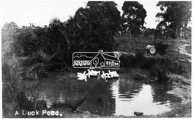
Photograph, Tom Prior, A Duck Pond, c.1900
The location was Fernie Hill where Ivy Reynolds's mother was born, over from Mr Traill's property at the corner of Reynolds and Main Road, Research - used to be called 3 Chain Road, now renamed Gumtree Road. The old Yarra River bed goes through here at top of hill in Gumtree Road. Gravel from this location was used for the driveways in Government House.This photo forms part of a collection of photographs gathered by the Shire of Eltham for their centenary project book,"Pioneers and Painters: 100 years of the Shire of Eltham" by Alan Marshall (1971). The collection of over 500 images is held in partnership between Eltham District Historical Society and Yarra Plenty Regional Library (Eltham Library) and is now formally known as the 'The Shire of Eltham Pioneers Photograph Collection.' It is significant in being the first community sourced collection representing the places and people of the Shire's first one hundred years.Digital image 4 x 5 inch B&W Negsepp, shire of eltham pioneers photograph collection, eltham, duck pond, reynolds prior collection, pond, fernie hill, gumtree road, research (vic.) -
 Eltham District Historical Society Inc
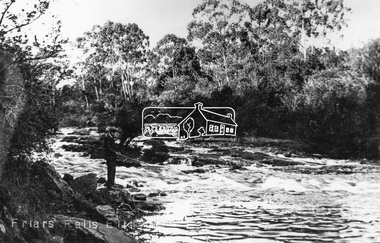
Negative - Photograph, Tom Prior, Friars Falls, Eltham, c.1910
Friars Falls is near Griffith Park, Eltham on the Yarra RiverThis photo forms part of a collection of photographs gathered by the Shire of Eltham for their centenary project book,"Pioneers and Painters: 100 years of the Shire of Eltham" by Alan Marshall (1971). The collection of over 500 images is held in partnership between Eltham District Historical Society and Yarra Plenty Regional Library (Eltham Library) and is now formally known as the 'The Shire of Eltham Pioneers Photograph Collection.' It is significant in being the first community sourced collection representing the places and people of the Shire's first one hundred years. The Reynolds family were early settlers in Research. The Reynolds/ Prior collection of photographs were taken by Tom Prior, the maternal uncle of Ivy Reynolds, around 1900 and the 60 photos in the album give a fine overview of many of the landmarks of Research and Eltham over 100 years ago. lvy lived in the family home for many years at 106 Thompson Cres Research. Ivy's father, Ernst Richard Reynolds and grandfather, Richard Reynolds, lived at the same address. Ivy's father Richard worked for Mr. Trail on his property in Research. Reynolds Road is named after the family. Mr Tom Prior (wife Eva) worked at the Melbourne zoo. He was very innovative and made his own camera, using the black cloth hood to exclude the light. The photographs are a reminder of the rural nature of Research and Eltham and its rich heritage.Digital image 4 x 5 inch B&W Negshire of eltham pioneers photograph collection, eltham, friars falls, griffith park, yarra river, reynolds prior collection -
 Eltham District Historical Society Inc
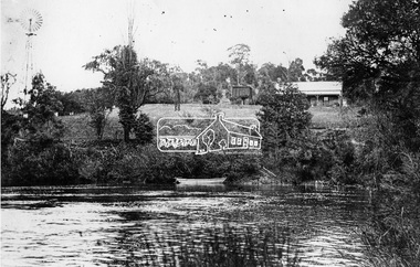
Negative - Photograph, ‘Worlingworth’, Yarra River, Eltham
‘Worlingworth’, Yarra River, Eltham Original homestead on the property ‘Worlingworth’, a large residence and surrounding farm site standing on a knoll above the River Yarra in Banoon Road, Eltham. The present house was built about 1922 and was originally owned by Mr A.R. Read, a stock and station agent and member of the Stock Exchange (who left the district in early 1926 to take up permanent residence at his Warburton property). It became the home of notable anthropologist Prof. Dr. Donald Thomson (1901-1971) and Mrs. Gladys Thomson who were married in 1925 and had twin sons in 1934 and is considered historically and aesthetically significant to the Shire of Nillumbik.This photo forms part of a collection of photographs gathered by the Shire of Eltham for their centenary project book, "Pioneers and Painters: 100 years of the Shire of Eltham" by Alan Marshall (1971). The collection of over 500 images is held in partnership between Eltham District Historical Society and Yarra Plenty Regional Library (Eltham Library) and is now formally known as 'The Shire of Eltham Pioneers Photograph Collection.' It is significant in being the first community sourced collection representing the places and people of the Shire's first one hundred years.Digital image 4 x 5 inch B&W Negshire of eltham pioneers photograph collection, a.r. read, banoon road, donald thomson, eltham, gladys thomson, worlingworth, yarra river -
 Eltham District Historical Society Inc
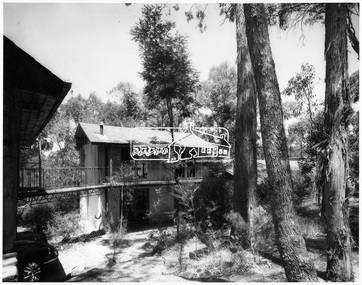
Photograph, Exterior of Professor Dick Downing's house - Eltham
Designed and constructed by Alistair Knox for Dorian Le Galliene, a composer and music critic and his companion Profesor Dick Downing as a weekend house in mud brick on the Yarra river at ElthamThis photo forms part of a collection of photographs gathered by the Shire of Eltham for their centenary project book,"Pioneers and Painters: 100 years of the Shire of Eltham" by Alan Marshall (1971). The collection of over 500 images is held in partnership between Eltham District Historical Society and Yarra Plenty Regional Library (Eltham Library) and is now formally known as 'The Shire of Eltham Pioneers Photograph Collection'. It is significant in being the first community sourced collection representing the places and people of the Shire's first one hundred years.Digital imagesepp, shire of eltham pioneers photograph collection, eltham, professor dick downing, alistair knox, dorian le galliene, house, dwelling, weekender -
 Eltham District Historical Society Inc
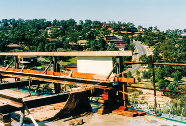
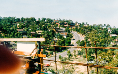
Photograph, Southeast view from new bridge over Plenty River looking along Plenty River Drive, Greensborough Bypass construction, c.1986, 1986c
... Southeast view from new bridge over Plenty River looking... photosafe storage. Southeast view from new bridge over Plenty River ...Mura Close and Tangari Court visible on left, Warriparri Crescent on right of Plenty River Drive.Colour photograph originally located in a magnetic style album titled 'Greensborough Bypass 1990s 5' suffering significant degradation. No information contained in album or on reverse of photos except where noted. Relocated to archival photosafe storage.greensborough bypass, road construction, greensborough, mura close, tangari crescent, plenty river drive, warriparri crescent -
 Eltham District Historical Society Inc
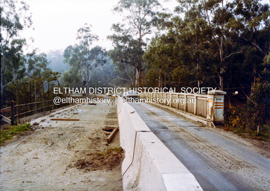
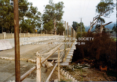
Photograph, Ruth H. Pendavingh, Widening of Main Road Bridge over the Diamond Creek, Eltham, 1984c
Three colour photographs of the construction work of the widening works of the bridge over the Diamond Creek, Eltham, near Lower Eltham Park Victoria. The bridge re-opened on October 25, 1984. (EDHS Chronology of known local events 1835- early 2000) eltham, main road, main road bridge, bridges, construction, diamond creek (river) -
 Eltham District Historical Society Inc
Photograph, Ruth H. Pendavingh, Widening of Main Road Bridge over the Diamond Creek, Eltham, 1984c
Three colour photographs of the construction work of the widening works of the bridge over the Diamond Creek, Eltham, near Lower Eltham Park Victoria. The bridge re-opened on October 25, 1984. (EDHS Chronology of known local events 1835- early 2000) eltham, main road, main road bridge, bridges, construction, diamond creek (river) -
 Kiewa Valley Historical Society
Postcard Circa 1950, Mt. Beauty Village, Kiewa Hydro-Electricity Project, circa 1950
This postcard was produced in the 1950's for the tourist trade in the Kiewa Valley and Alpine region. It encompasses the period when the State of Victoria was pressured by the ever increasing demand by industry and its population for electricity supplies. Hydro electricity was seen as an untapped natural resource to quench this demand. The Victorian Alps and the rivers flowing into its valleys was ideal for the construction of the Kiewa Hydro Electricity Scheme. The late 1940's saw the development of this scheme and the changing of sections of alpine landscape is covered by this and other postcards/pictures (tourists, construction workers, and established rural populations). This period in time was before the established wildlife and forest/nature groups became political activist who changed legislative acts to protect the environment. The regulatory pondage on the northern aspect of the village had no water over-spill from the unfinished power station.This rural region in 1950 (Kiewa Valley/alpine plains) was at most only significant to a smaller group of winter sports, summer hikers/horse riders and rural farmers/graziers. The numbers of tourists and the increase in the local resident population was boosted by the construction of the Hydro Electricity Scheme. This influx to the regional population resulted in a corresponding diversity in services and brought about an environment that responded to a growing level of tourists and thereby permitting this industry to grow more rapidly than it would have naturally. This postcard details an attraction to the "cleaner" method of providing electricity. This postcard was purchased in 1950 by a surveyor at Landford's Gap. The couple shown in this photograph would have been employed by the S.E.C. under the Kiewa Hydro-Electricity Scheme.This item is a scanned black and white photograph of a panoramic view of Mount Beauty Village in 1950 (a closed village, entry by pass only). The regulatory pondage has earthen walls but no water.See 0480 (A) -(D) and (F) for other photos of similar postcards"MT. BEAUTY VILLAGE KIEWA HYDRO-ELECTRIC PROJECT"kiewa valley tourism, victorian alps, alternate energy supplies, alpine population growth -
 Kiewa Valley Historical Society
Sketch Tree Bark, Aboriginal - bark removed from tree
This sketch of a tree whose bark was cut, by aboriginal craftsmen, to produce a canoe for fishing in the rivers running through the Kiewa Valley either before or just after the 1800's. The tree trunk depicted in the sketch would have been used at the beginning of European settlement in the Kiewa Valley or just before contact was made.As this sketch was of a tree found along the Kiewa River it indicates that Aborigines lived by the river. This sketch depicts the usage of tree bark by the Aboriginal fisher person in crafting a canoe to cross rivers and to fish in the deeper sections of the river course.This freehand sketch detailing the outline of bark removed to provide a canoe is in ink portraying a tree trunk with one branch which has a plaque in front a gravel section to the right and open fields in the mid background and scattered trees on a hill slope in the far background. The sketch is on thick cardboard with a plastic protective cover over it (fastened on the flip side). It is a sketch of the tree now exhibited at the Kiewa Consolidated School.Written in black ink on the top section (heading) "ABORIGINES CUT CANOE FROM TREE. NOW AT KIEWA SCHOOL"crafted canoe, aboriginal craftsmanship, tree usage, early aboriginal craftsmen, kiewa river. kiewa consolidated school -
 Eltham District Historical Society Inc
Photograph, Jim at "The Pub" Eltham; Reed's Eltham Hotel, c.1948
Olive Elsie May Reed was licensee of the Eltham Hotel from April 1948 to January 1950. The Eltham Hotel is the oldest continually operating hotel in the Eltham district. Initially referred to as the Little Eltham Hotel, it has been known as the Eltham Hotel since the 1850s through to present time with a very brief period as the Eltham Tavern in the late 1980s. Benjamin Oliver Wallis was a prominent Eltham resident, publican and Councillor during the second half of the nineteenth century. He owned the house that is now the Nillumbik Living and Learning Centre at 739 Main Road Eltham and one stage the Eltham Hotel. Wallis migrated to Melbourne in 1853 but his wife and children remained in Cornwall for a further 10 years. Later in 1853 Richard Warren engaged Wallis to build the Eltham Hotel and it opened in 1854. The hotel was constructed of hard basaltic blue stone quarried in the Eltham district and cemented together with mud, and partly of bricks made at Eltham. The Fountain of Friendship Hotel on the opposite side of Maria Street (Main Road) opened shortly after. The hotel was a well-known resting place for gold diggers during the gold rush at Woods’ Point and Warren would buy the gold from the diggers. In 1858 Warren fell into financial difficulties and had to sell the hotel. Wallis bought the hotel and obtained a publican’s licence in 1861. In the 1850s the Fountain had been the more popular hotel but after that the Eltham Hotel became more popular. It is understood that in about 1857 Wallis probably built the “Living and Learning house” for tanner John Pearson. In 1868 Pearson became bankrupt and Wallis acquired the house and he lived there until his death in 1896. For some of this time the house was in the name of Benjamin’s son Richard but he died in 1888 and ownership reverted to his father. Wallis was a member of the Eltham Jockey Club and in 1867 his wife Anna rode her horse Charlotte in the Annual Races. Anna was also an angler and is reported to have caught a large perch in the Yarra River. She died in 1887. On 16th September 1886 Wallis sold the hotel to Christopher Watson (Snr). Watson died in 1887 and the hotel passed to his son Christopher Watson (Jr) who owned it until his death in 1909 at which time his wife Emily took over the license. Upon her death, their son Herbert applied for the license in January 1915. In July 1925, Herbert Watson demolished the original building and, in its place, erected a modern hotel which remains the foundation of the present Eltham Hotel. The contractors at the time commented on how well the original building had been constructed. A description of the new building was detailed in the Advertiser newspaper of January 8, 1926: “The new building consists of. two stories. designed in English tavern style, and contains-all told, 24 rooms. On the second floor, in front uninviting the two gables is a deep balcony, which will be much appreciated by visitors. The lower story is wholly of brick, and the upper one of wood and fibrous cement plaster. The rooms are spacious and lofty, and the windows are large and of latest style, and light the rooms splendidly. The entrance hall is 8 feet wide. The bar is a very commodious room and is furnished in the most up-to-date and convenient manner. The dining room, a very attractive apartment, is 30 feet by 15 feet 6 inches, and the bar parlor is also a large and well furnished room. A large cellar, an indispensable adjunct to an hotel, has been excavated beneath the bar. On the upper story are 12 bedrooms, and among other conveniences are two bath rooms in which hot and cold water can be used. All the rooms have been supplied with the necessary appliances for electric lighting, which will be one of the progressive evidences which Eltham will shortly enjoy.” “In the yard a brick garage to accommodate three cars at once, has been erected. This, as well as the hotel, is roofed with tiles.” “From the front of the hotel (especially the balcony) a lovely view of the country west and, north may be obtained.” “It may be added that it Is intended to have an ornamental garden, a tennis court. and a kiosk in connection with the hotel, and the property will have a rustic fence round it.” The hotel has since undergone several modifications and extensions Pages from a scrapbook belonging to Heather Jenkins (nee Sargeant) who lived as a child in the Police Residence at 728 Main Road, Eltham in the 1920s.Heather Sargeant was the daughter of Constable W.C. Sargeant, the local police officer in residence at Eltham, 1922-1927Glued on a brown paper scrapbook page (torn from scrapbook) with 8 black and white/sepia photos of varying sizes, 1 newspaper clipping and one greeting card with printed sketch and handwritten captions in ink. On back of page is 1 black and white photo and a large newspaper clipping.eltham, police residence, heather jenkins (nee sargeant), walter withers, constable w.c. sargeant, eltham hotel, jim jenkins, reed's eltham hotel, olive elsie may reed -
 Eltham District Historical Society Inc
Photograph, Liz Pidgeon, Heritage Excursion; Back-track walk to Fitzsimons Lane, 2 July 2016, 2 July 2016
Newsletter No., 228, June 2016 Heritage Excursion – Back-track walk to Fitzsimons Lane – Saturday 2nd July Our July heritage excursion will be a walk to Yarra Hill Close and Fitzsimons Lane Bridge, based on the story on pages 3 and 4. Although the route is close to Fitzsimons Lane it will follow streets and paths that may not be familiar to many local residents. It will include commentary on the history of this corner of the Town of Eltham. This walk on Saturday 2nd July will follow a “there and back” route, that is returning over much the same course. It is about 2.5 km in length and will take 2 to 2.5 hours. It includes some hills. It will start at 2pm at the corner of Bolton Street and Old Eltham Road (Melway ref.21 F10).Born Digitalelection day, heritage excursion, activities, eltham district historical society, fitzsimons lane, yarra river