Showing 25576 items matching "plenty-township-estate"
-
 Whitehorse Historical Society Inc.
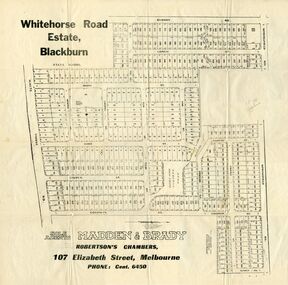
Document, Whitehorse Road Estate
Plan of blocks for sale on the Whitehorse Road EstatePlan of blocks for sale on the Whitehorse Road Estate, Blackburn. 2 copies.Plan of blocks for sale on the Whitehorse Road Estateland subdivision, whitehorse road estate, blackburn, springfield road, goodwin street, surrey road, esdale street, larch street, maple street, musk street, elder street, linden street, elm street, fir street, barnes estate -
 Whitehorse Historical Society Inc.
Pamphlet, Auction - Pope's Estate
Physical description Pope's Estate, Box HillPope's Estate, Box Hill subdivisional auction, 7/12/1929Physical description Pope's Estate, Box Hill duncan & weller, auctioneers, duckham street, blackburn, hirst street, middleborough road, canterbury road, amery avenue -
 Whitehorse Historical Society Inc.
Document, Toogood's Estate, 15/12/1956 12:00:00 AM
Auction brochure of Toogood's Estate, Middleborough Road, Box Hill NorthAuction brochure of Toogood's Estate, Middleborough Road, Box Hill NorthAuction brochure of Toogood's Estate, Middleborough Road, Box Hill Northtoogood's estate, box hill north, middleborough road, box hill -
Whitehorse Historical Society Inc.
Pamphlet - Advertising Brochure, The Surrey Estate Mitcham, circa 1948
Brochure detailing plan and prices of Surrey Estate, Mitcham, ca 1948.surrey estate, land sales, mitcham road, mitcham, rosstrevor crescent, alwyn street -
 Whitehorse Historical Society Inc.
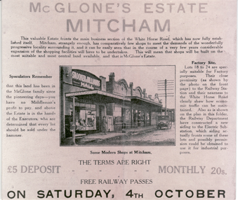
Photograph - Black and white photograph, McGlone's Estate, Mitcham. 1924
Black and white photo of Brochure for Auction of McGlone's Estate, Mitcham. 1924.auctions, mcglone estate -
 Eltham District Historical Society Inc
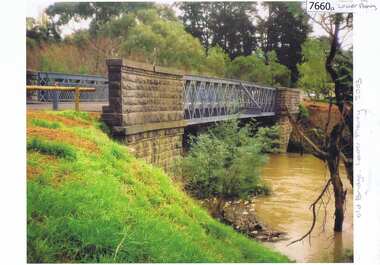
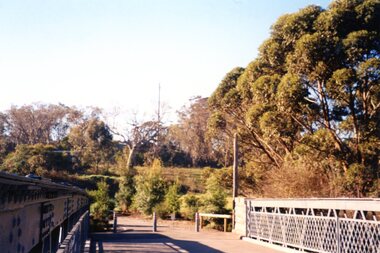
Negative - Photograph, Old Lower Plenty Bridge, 18 April 1998
Plenty River reflections through the old iron Lower Plenty Bridge; Autumn Excursion to Lower Plenty area. The blocked-off iron bridge at Lower Plenty - now re-opened and used as a footway/bike path section joining the Yarra River path.Roll of 35mm colour negative film, 2 strips and associated colour printKodak Gold 200-6activities, lower plenty bridge, autumn excursion, eltham district historical society, lower plenty -
 Greensborough Historical Society
Photograph - Photograph (Copy), Anne Paul, Old bridge, Lower Plenty 2003, 2003_12
Two views of the old bridge over the Plenty River in Lower Plenty.2 colour photographs printed on paper, handwritten captionslower plenty, plenty river, floods, edward willis drive lower plenty -
 Greensborough Historical Society
Photograph - Photograph Collection, Anne Paul, Lower Plenty Bridge and surrounds, 2002c
Six photographs of the area surrounding the Old Plenty Bridge in Lower Plenty6 colour photographs lower plenty, plenty river, old plenty bridge -
 Greensborough Historical Society
Slide - Photograph, John Ramsdale, Lower Plenty houses: Slide 79, 1990s
Photograph shows a residential street in Lower Plenty - the Plenty River is behind.Part of the John Ramsdale collection of slides and audio visual material.Colour photograph scanned from slide.No caption. Printed maker's mark on slide "Kodak Kodachrome Slide"lower plenty, plenty river, residential development -
 Ringwood and District Historical Society
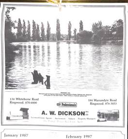
Souvenir - Complimentary A.W.Dickson Real Estate Agents calendars, Complimentary A.W.Dickson Real Estate Agents calendars - 1987 and 1988.1987 calendar with photographic images of local Ringwood features and 1988 calendar featuring local Ringwood land sale promotional images from early 20th Century
A.W.Dickson was a Real Estate Agent in Ringwood for many years. These calendars show the local buildings of the day. For example the original Eastland 's building of 1967, Maroondah Hospital 1976 and the Civic Centre now the Karralyka Centre.1 1987 calendar with six black and white photos of buildings and vistas around Ringwood with monthly dates in lower quarter of page. 2 1988 calendar with six posters advertising early 20th century land sales in Ringwood, Heathmont and Ringwood East with dates in lower quarter of page Compiled by A.W.Dickson Pty. Ltd. Real Estate Agent. Photographed by C.M.S. Photographers - 725 9441 (January February 1987) RINGWOOD LAKE - Ideal picnic spot for Ringwood Model power boats frequently on display. Barbecue area, playground, resting place for old steam engine. Yabbie netting is a favourite pastime here. (March April 1987) CLOCK TOWER - Moved from its former site on Warrandyte Road corner in 1967 and re-built in its present location, brick by brick. A wreath laying ceremony is held here on Anzac day each year. (May June 1987) RINGWOOD AQUATIC CENTRE - A world class swimming facility opened in 1986 at a cost of $3 million. Featuring the latest ozone water treatment techniques. In summer folding doors can be opened to give access to existing outdoor pools and sunbathing area. (July August 1987) MAROONDAH HOSPITAL - Opened in 1976 after many years of fund raising efforts by local people. The opening of casualty facilities was welcomed by locals as previously Box Hill Hospital catered for the entre area. (September October 1987) EASTLAND - Opened October 1967. Built on a former football oval. Now about to undergo major extensions to cater for Ringwood's population growth into the 21st Century. November December 1987 CIVIC CENTRE - Built on the site of a former antimony mine behind the council offices. Now the venue for many activities and a local point for Ringwood's Cultural Life. -
 Eltham District Historical Society Inc
Negative - Photograph, J.A. McDonald, Eltham-Yarra Glen Road, Lower Plenty footbridge, Sep. 1955
The Eltham-Yarra Glen Road as designated originated at the Shire of Eltham boundary at the Plenty River. West of the river the road was known as the Heidelberg-Eltham Road. The section from the Plenty River is now known as Lower Plenty Road which becomes Main Road. The footbridge no longer exists but was originally sited to the south, adjacent to the old Lower Plenty Bridge, now part of the Plenty River Trail. Record of various Shire of Eltham infrastructure works undertaken during the period of 1952-1962 involving bridge and road reconstruction projects, sometimes with Eltham Shire Council Project Reference numbers quoted. It was during this period that a number of significant improvements were made to roads and new bridges constructed within the shire that remain in place as of present day (2022). In many situations, the photos provide a tangible visible record of infrastructure that existed throughout the early days of the Shire. The album was put together by or under the direction of the Shire Engineer, J.A. McDonald.1955-09, eltham-yarra glen road, lower plenty footbridge, lower plenty, lower plenty bridge, lower plenty road, main road, plenty river trail, bridge construction, infrastructure, shire of eltham -
 Kew Historical Society Inc
Plan - Subdivision Plan, Palmyra Estate, 1918
Pru Sanderson, in her groundbreaking ‘City of Kew Urban Conservation Study : Volume 2 - Development History’ (1988), summarised the periods of urban development and subdivisions of land in Kew. The periods that she identified included 1845-1880, 1880-1893, 1893-1921, 1921-1933, 1933-1943, and Post-War Development. These periods were selected as they represented periods of rapid growth or decline in urban development. An obvious starting point for Sanderson’s groupings involved population growth and the associated economic cycles. These cycles also highlighted urban expansion onto land that was predominantly rural, although in other cases it represented the decline and breakup of large estates. A number of the plans in the Kew Historical Society’s collection can also be found in other collections, such as those of the State Library of Victoria and the Boroondara Library Service. A number are however unique to the collection.The Kew Historical Society collection includes almost 100 subdivision plans pertaining to suburbs of the City of Melbourne. Most of these are of Kew, Kew East or Studley Park, although a smaller number are plans of Camberwell, Deepdene, Balwyn and Hawthorn. It is believed that the majority of the plans were gifted to the Society by persons connected with the real estate firm - J. R. Mathers & McMillan, 136 Cotham Road, Kew. The Plans in the collection are rarely in pristine form, being working plans on which the agent would write notes and record lots sold and the prices of these. The subdivision plans are historically significant examples of the growth of urban Melbourne from the beginning of the 20th Century up until the 1980s. A number of the plans are double-sided and often include a photograph on the reverse. In 1918, Punch reported the sale of the Palmyra Estate. ‘Adjoining the Findon Estate at Kew is Palmyra, one of the most charming localities in this most desirable of all suburbs. Palmyra has frontages to Findon, Bakewell, Carson and Stevenson streets. Facing Carson street are eight blocks of 60 by 140; on Stevenson-street four of 60 by 232; and there are four of 60 by 233 on Bakewell-street.’ [Bakewell Street and Findon Street were later to be amalgamated into Findon Crescent.]subdivision plans - kew, studley park, palymyra estate, stevenson street -- kew (vic.), carson street -- kew (vic.), bakewell street (findon crescent) -- kew (vic.) -
 Ringwood and District Historical Society
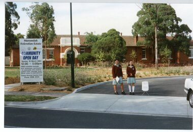
Photograph, Federation Estate -Ringwood. Community Open day 2001
Coloured photograph"Written on back of photograph" Federation Estate -Community Open Day -2001 -
 Ringwood and District Historical Society
Photograph, Federation Estate -Ringwood. Community Open day 2001
Coloured photograph"Written on back of photograph" Federation Estate -Community Open Day -2001 -
 Ringwood and District Historical Society
Photograph, Federation Estate -Ringwood. Community Open day 2001
Coloured photograph"Written on back of photograph" Federation Estate -Community Open Day -2001 -
 Ringwood and District Historical Society
Photograph, Federation Estate -Ringwood. Community Open day 2001
Coloured photograph"Written on back of photograph" Federation Estate -Community Open Day -2001 -
 Ringwood and District Historical Society
Photograph, Federation Estate -Ringwood. Community Open day 2001
Coloured photograph"Written on back of photograph" Federation Estate -Community Open Day -2001 -
 Ringwood and District Historical Society
Photograph, Federation Estate -Ringwood. Community Open day 2001
Coloured photograph"Written on back of photograph" Federation Estate -Community Open Day -2001 -
 Ringwood and District Historical Society
Photograph, Federation Estate -Ringwood. Community Open day 2001
Coloured photograph"Written on back of photograph" Federation Estate -Community Open Day -2001 -
 Ringwood and District Historical Society
Photograph, Federation Estate -Ringwood. Community Open day 2001
Coloured photograph"Written on back of photograph" Federation Estate -Community Open Day -2001 -
 Ringwood and District Historical Society
Photograph, Federation Estate -Ringwood. Community Open day 2001
Coloured photograph"Written on back of photograph" Federation Estate -Community Open Day -2001 -
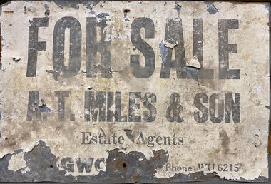 Ringwood and District Historical Society
Sign - For Sale Sign - circa 1950, Real Estate sign - A.T. Miles & Son, Ringwood, Victoria
Weathered sign printed on paper glued to metal backing.FOR SALE A.T. MILES & SON, Estate Agents, Ringwood, Phone WU6215. -
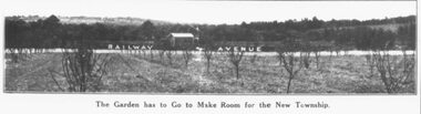 Ringwood and District Historical Society
Photograph, Ringwood East - Railway Station Estate, 1925
Catalogue card reads, "Ringwood East - Railway Station Estate, 1925". -
 Kew Historical Society Inc
Plan, Studley Park Estate, 1910
Prue Sanderson, in her groundbreaking ‘City of Kew Urban Conservation Study : Volume 2 - Development History’ (1988), summarised the periods of urban development and subdivisions of land in Kew. The periods that she identified included 1845-1880, 1880-1893, 1893-1921, 1921-1933, 1933-1943, and Post-War Development. These periods were selected as they represented periods of rapid growth or decline in urban development. An obvious starting point for Sanderson’s groupings involved population growth and the associated economic cycles. These cycles also highlighted urban expansion onto land that was predominantly rural, although in other cases it represented the decline and breakup of large estates. A number of the plans in the Kew Historical Society’s collection can also be found in other collections, such as those of the State Library of Victoria and the Boroondara Library Service. A number are however unique to the collection.The Kew Historical Society collection includes almost 100 subdivision plans pertaining to suburbs of the City of Melbourne. Most of these are of Kew, Kew East or Studley Park, although a smaller number are plans of Camberwell, Deepdene, Balwyn and Hawthorn. It is believed that the majority of the plans were gifted to the Society by persons connected with the real estate firm - J. R. Mathers and McMillan, 136 Cotham Road, Kew. The Plans in the collection are rarely in pristine form, being working plans on which the agent would write notes and record lots sold and the prices of these. The subdivision plans are historically significant examples of the growth of urban Melbourne from the beginning of the 20th Century up until the 1980s. A number of the plans are double-sided and often include a photograph on the reverse. A number of the latter are by noted photographers such as J.E. Barnes.Coloured lithograph of a subdivision plan of the Studley Park Estate, bordered by Yarra, Willsmere Road and the Outer Circle Railway line. The estate was listed in 1910 and was the subject of a planning dispute between the developer and the Town of Kew in relation to flood levels and the suitability of the land for housing. In many cases the names of streets were subsequently changed. The layout was also affected by the creation of the Eastern Freeway. A newspaper report of the day described the subdivision as a: "GOLDEN OPPORTUNITY. We are pleased to submit for PRIVATE SALE that magnificent ESTATE, situated only 4 1/2 miles from the Melbourne General Post Office, STUDLEY PARK ESTATE. KF/NV. Doubtless the CHEAPEST LAND EVER OFFERED having extensive frontages to the prettiest spot on the River Yarra and the National Park, commanding lovely river and landscape views, and acknowledged to be the finest land available so close to the city. The PRICES ARE EXTREMELY MODERATE; The TERMS ARE SIMPLY MARVELLOUS. NO DEPOSIT. NO DEPOSIT. NO DEPOSIT. Allotments and prices to suit everyone."subdivision plans - kew, studley park estate -
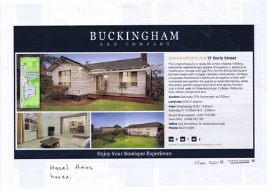 Greensborough Historical Society
Advertising Leaflet, Buckingham and Company Estate Agents, 17 Doris Street Greensborough, 2019_01
Advertising for 17 Doris Street Greensborough, 2 bedroom house with bungalow, sold January 2019 for $662,000. This was the home of Hazel Amos and family.Colour page from real estate magazine and advertising leaflet from open house. doris street greensborough, hazel amos -
 Greensborough Historical Society
Photograph - Photograph (Copy), Anne Paul, Water Watch under old bridge, Lower Plenty 1990s, 1990s
Two views of "Waterwatch" working around the bridge over the Plenty River in Lower Plenty.2 colour photographs printed on paper, handwritten captionslower plenty, plenty river, waterwatch -
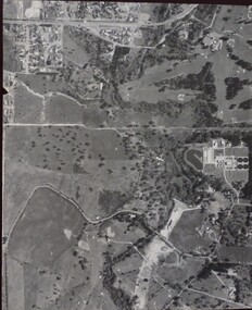 Greensborough Historical Society
Aerial Photograph, Banyule Road / Lower Plenty Road, 1972c
Viewbank, Rosanna and Lower Plenty area, showing Lower Plenty Road and Banyule RoadAerial survey photograph, black and whiteviewbank -
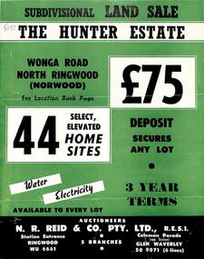 Ringwood and District Historical Society
Flyer, Land Sale Brochure, The Hunter Estate, North Ringwood, Vic. - circa 1960
Bi-fold land sale advertisement for The Hunter Estate, North Ringwood, including terms of sale, area map, layout of the estate, and summary of local facilities and services, with separate attachment listing lot number prices.Subdivision includes Wonga Road, Hunter Avenue (later Graeme Avenue), Panfield Avenue, Hendra Grove, and Mullum Mullum Road. Agent - N.R. Reid & Co. Pty. Ltd., Station Entrance, Ringwood. (Phone) WU 6661. -
 City of Kingston
Pamphlet - Colour, T. H. Ould Publishing Co, The Ridge Estate, Cheltenham, c. 1930
Sales plan for land in the suburb of Cheltenham, bounded by Johnston Street, Silver Street and Cavanagh Street, incorporating lots on either side of Sunray Avenue.The developing urban area of Cheltenham within the City of Kingston. This land sale pamphlet illustrates the subdivision of land within the municipality and the changing demographic of the district as new houses are constructed close to infrastructure.Colour pamphlet advertising for sale lots in The Ridge Entrance Estate, Cheltenham. Incorporates a map of the estate bordered by Johnston Street, Silver Street and Cavanagh Street, including subdivision lots on either side of Sunray Avenueland sales, estate, cheltenham -
 Eltham District Historical Society Inc
Negative - Photograph, J.A. McDonald, Eltham-Yarra Glen Road, Lower Plenty footbridge, Sep. 1955
Tony Carberry and J. Jolly The Eltham-Yarra Glen Road as designated originated at the Shire of Eltham boundary at the Plenty River. West of the river the road was known as the Heidelberg-Eltham Road. The section from the Plenty River is now known as Lower Plenty Road which becomes Main Road. The footbridge no longer exists but was originally sited to the south, adjacent to the old Lower Plenty Bridge, now part of the Plenty River Trail. Record of various Shire of Eltham infrastructure works undertaken during the period of 1952-1962 involving bridge and road reconstruction projects, sometimes with Eltham Shire Council Project Reference numbers quoted. It was during this period that a number of significant improvements were made to roads and new bridges constructed within the shire that remain in place as of present day (2022). In many situations, the photos provide a tangible visible record of infrastructure that existed throughout the early days of the Shire. The album was put together by or under the direction of the Shire Engineer, J.A. McDonald.1955-09, eltham-yarra glen road, lower plenty footbridge, j. jolly, lower plenty, lower plenty bridge, lower plenty road, main road, plenty river trail, tony carberry, bridge construction, infrastructure, shire of eltham