Showing 774 items matching "proposed plans"
-
 Lakes Entrance Historical Society
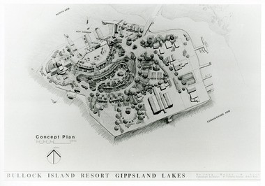
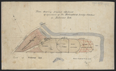
Photograph - Bullock Island, 1991
... Black and white photograph of a concept plan for a proposed... plan for a proposed multi million dollar tourism complex ...Date made September 1991Black and white photograph of a concept plan for a proposed multi million dollar tourism complex to be built on Bullock Island, Lakes Entrance, Victoria.Bullock Island Resort Gippsland Lakes islands, development -
 Whitehorse Historical Society Inc.
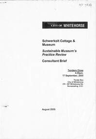
Document - Tender, City of Whitehorse, Sustainable Museum's Practice Review - Schwerkolt Cottage and Museum, August 2005
Consultant Brief seeking tenders for a feasibility study on whether or not to extend and upgrade the Schwerkolt Cottage, Museum and equipment display with concept designs as required. Includes a proposed staging budget.Consultant Brief seeking tenders for a feasibility study on whether or not to extend and upgrade the Schwerkolt Cottage, Museum and equipment display with concept designs as required. Includes a proposed staging budget. Consultant Brief seeking tenders for a feasibility study on whether or not to extend and upgrade the Schwerkolt Cottage, Museum and equipment display with concept designs as required. Includes a proposed staging budget. sustainable development, schwerkolt cottage and museum development, city of whitehorse -
 Whitehorse Historical Society Inc.
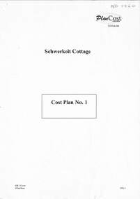
Document - Project Plan, City of Whitehorse, Schwerkolt Cottage - Cost Plan No.1, 23/02/2006
A cost analysis for the extension, alteration and repairs to the Schwerkolt Museum building and construction of a new building for the agricultural exhibits.A cost analysis for the extension, alteration and repairs to the Schwerkolt Museum building and construction of a new building for the agricultural exhibits.A cost analysis for the extension, alteration and repairs to the Schwerkolt Museum building and construction of a new building for the agricultural exhibits.city of whitehorse, schwerkolt cottage and museum complex, museum development, agricultural machinery -
 Kew Historical Society Inc
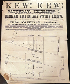
Plan, Kew! Kew!, 1888
The Land Boom of the 1880s accelerated the rate of subdivisions in Kew. This subdivision, 'Kew! Kew!' was also impacted by, or resulted from, the decision by the Victorian Government to construct the Outer Circle railway. Construction of the railway began in 1888 and was completed in 1891. Plan of an 1888 subdivision bounded by Bulleen Road (now High Street), Gladstone Street (now Campbell Street?), Park Street (now Adeney Avenue), and Belmore Road (now Harp Road). The 16 lots in the proposed subdivision are bisected by the route of the Outer Circle railway, and next to the proposed Normanby Station (later renamed East Kew). On the plan, local landmarks such as the tram terminus, the Harp of Erin hotel, and the station are located. The street where the lots are numbered , was called Welsh Street on the plan as this was the name of the vendor. Surrounding land owners are also named: G. Smith Esq, Matthew Maher Esq, and Maurice Neligan Esq.outer circle railway, land subdivisions -
 Warrnambool and District Historical Society Inc.
Document - Warrnambool City Council Preliminary Report Industrial Estate West Warrnambool, E Johnson, 9 March 1973
This preliminary report relates to 32½ acres of council owned land in West Warrnambool bounded on the North by McMeekin Road, on the East by Scott Street, on the South by Evans Street and on the West by the rear boundaries of properties facing Landmann and Granter Streets. In 2010, West Warrnambool was the largest of Warrnambool’s existing industrial areas, comprising approximately 109ha of industrial zoned land, the majority of which (101ha) is zoned IN1Z, with the remainder zoned INZ3. The area comprises a mixture of lot sizes supporting a diverse mix of industries. Larger parcels are occupied by the abattoirs, scrap metal industries, freight, the Council Depot and storage. Smaller lots are occupied by smaller manufacturers and wholesalers and service industries. [Ref: Warrnambool Industrial Land Use Review. Mesh Pty Ltd July 2010]This document is a preliminary report prepared by the Warrnambool City Council Engineer in March 1973 and provides an example of the planning process undertaken to develop one of Warrnambool's industrial areas. It contains details and costings of the proposed subdivision. Two foolscaps size pages of typewritten information. A detailed topographical map of the area with areas highlighted in blue, red, green, blue and purple pen.warrnambool city council, west warrnambool, industrial estate -
 Falls Creek Historical Society
Letter - Proposal To Extend Present Chair Lift
... Committee requesting detailed plans for the proposed extension... Tourist Area Management Committee requesting detailed plans ...Bob Hymans Collection Bob (Herman) Hymans (a former member of the Royal Netherlands Navy was born in Bloemendaal, Holland on 30th September 1922. During World War II he fought against the Japanese in the Dutch East Indies (now Indonesia) and was imprisoned in Changi and on the Burma Railway. After gaining qualifications as a Ski Instructor, Bob arrived in Falls Creek in May 1950. Working as an Instructor and Supervisor at Bogong Lodge, Bob decided his future was in accommodation. He was successful in negotiating an indenture for land from the State Electricity Commission (SEC). It took Bob two years to build his Grande Coeur Chalet but, tragically, it was burned down in August 1961. Bob also built the first Chairlift in Australia. This was a single chairlift and the structure was built from wooden electricity poles. He was constantly full of new ideas and proposals for the village. Bob Hymans died on 7th July 2007. This Collection of documents and letters tells the story of Bob’s endeavours to develop Falls Creek into the ski village it is today.This document is significant because it documents the Bob Hymans' proposals for Falls Creek..A letter from the Falls Creek Tourist Area Management Committee requesting detailed plans for the proposed extension of Bob Hymans' chairlift.chairlift falls creek, bob hymans, falls creek tourist area -
 Hymettus Cottage & Garden Ballarat
Medal - Medallion, Western Victorian Games Australian Bicentenary medal
Australian Bi-Centennial medal issued for the Western Victorian Games 1988, the only time these games were undertaken despite initial plans to be a regular event.Held in 1988 the Western Victorian Games were a Bi-Centennial project of the Victorian Government proposed to be held every four years but never repeated after 1988.circular medallionAustralian Bi-Centenniarymedal, sport, westerrn victorian games -
 Falls Creek Historical Society
Magazine - Fall-Line - Australia's National Skiing Magazine July - Aug 1979
“Fall-Line” was one of a series of magazines published by the Victorian Ski Association. It was produced from 1979 until 1985. It superseded their previous publication, “Ski” magazine and was followed by the “Australian Skiing” magazine. The Victorian Ski Association was formed in 1955.This magazine is significant because it documents developments in the ski industry in Australia.A magazine featuring a coloured image on the cover and containing articles and advertising related to developments in skiing in Australia. This issue included an extensive article discussing the possible of the development of Lakeside Resort on the shores of Rocky Valley Dam as well as an update on recent changes at Falls Creek. FALLS CREEK The ski patrol has been increased from seven to eight, under the leadership of Senior Patroller John McDonald, and two new radios have been purchased. A four wheel drive ambulance has been purchased to replace the old conventional drive model. It will provide free ambulance transport between Falls Creek and Mt. Beauty, and will be driven by trained volunteer personnel. A new 165 vehicle day visitor car park has been completed at Windy Corner, adjacent to the approved toboggan slope. The closest car park to Falls Creek's Nordic Preferred Area, its capacity will be doubled next summer. A planning permit has been issued to Treglor Pty. Ltd. for its proposed hotel/convention centre. Construction is expected to begin after the season. A new Mercedes 800 tractor with Schmidt Snowcutter recently arrived on the mountain and will be used to clear the car parking areas Falls Creek continues to be among Australia's most expensive resorts, with a high season day ticket price of $13.50. Falls Creek's newest commercial lodge, Lakeside Lodge, has opened with accommodation for more than 50 people and luxury facilities including private rooms with full ensuite, sauna, spa pool, and a dining room for guests. It is located at the top of Schuss St. just behind Imaj flats and very close to the village bowl.australian ski magazines, skiing australia, victorian ski association -
 Eltham District Historical Society Inc
Photograph - Digital Photograph, Alan King, Eltham Living and Learning Centre, 26 January 2008
In 1857, tanner John Pearson purchased three and a half acres of land in Little Eltham, at the western end of Pitt Street, with a 70-foot frontage to Maria Street (Main Road) and stretching down to the Diamond Creek for £100. He contracted Benjamin Oliver Wallis to build house for him. Wallis, a mason by trade who originated from the Cornish village of Newlyn, migrated to Melbourne in 1853 and was shortly engaged by Richard Warren to build the Eltham Hotel, which opened in 1854. When Warren fell into financial difficulty in 1858, Wallis purchased the hotel. That same year, Pearson constructed a tannery below the house with access to the water in the Diamond Creek. When Pearson became bankrupt in 1867, Wallis similarly acquired the house from Pearson’s creditors in 1868 and lived there until his death in 1896. For some of this time the house was in the name of Wallis’s son Richard but following his death in 1888, ownership reverted to his father. It was purchased by retired teacher Richard Gilsenen in 1899. Gilsenen was made acting head teacher at the Eltham State School in 1906 following the sudden death of head teacher John Brown. In the 1950s the house was bought by retired engineer Dr Alfred Fitzpatrick and his wife Claire who made various modifications to house goats and poultry as well as structural modifications to the house. In the early 1970s, Eltham Shire Councillors Frank Maas and Don Maling proposed an extended communities’ activities program be set up and the Commonwealth Grants Commission was approached for financial assistance. In 1974 a $50,000 Commonwealth Grant was received by the Shire Council to acquire the Fitzpatrick property as part of the planning to establish an extended communities’ activities program. The Fitzpatricks moved next door and Claire taught at the new Living and Learning Centre, which began in 1975, one of the first community education centres in Victoria. Covered under Heritage Overlay, Nillumbik Planning Scheme. Published: Nillumbik Now and Then / Marguerite Marshall 2008; photographs Alan King with Marguerite Marshall.; p59 It’s a centre for sharing knowledge and friendship and it stands on the former hub of Eltham’s original township near Pitt Street. The Eltham Living and Learning Centre, with around 2000 participants a year, began in 1975 as one of the first Community Education Centres in Victoria. Classes ranging from macramé to wine making to environmental living have enriched the lives of thousands of people through the generosity of tutors sharing their skills free of charge. The centre’s heart is the brick cottage, built in 1858 by tanner John Pearson. He bought the three and a half acre (1.4ha) allotment fronting Maria Street (now Main Road) and stretching down to the Diamond Creek. The allotment formed part of a 316 acre (127.8ha) subdivision, owned by Josiah Holloway, called Little Eltham, north of the original Eltham Reserve.1 The allotment then passed through the hands of several speculators before it was sold to Pearson for £100 in 1857. Mr Pearson’s children attended the Eltham Primary School from 1864 to 1867. But creditors took possession of the property when his tannery folded in 1867. It was then sold to publican Benjamin Wallis, who owned the Eltham Hotel at the corner of Pitt Street and Main Road. In 1899 the property was bought by Richard Gilsenan, who became acting head teacher of the Eltham Primary State School in 1906. In the 1950s, retired engineer Dr Alfred Fitzpatrick and his wife Claire bought the property, and made structural changes. Claire, a journalist and community campaigner, modified and built pens for goats and poultry, a stable, a garage and planted fruit trees and a vegetable garden. In the early 1970s a young woman called Carina Hack approached Gwen Wesson at the Diamond Valley Learning Centre (Victoria’s first Community Education Centre) about starting a community centre. Following Wesson’s suggestion, Hack spoke to Shire President Alistair Knox ‘one bleak rainy afternoon, sipping hot drinks and discussing life’.2 Eltham Shire Councillors Frank Maas and Don Maling proposed a community activities program and the council received a $50,000 Commonwealth Government Grant for this venture.3 The Fitzpatricks sold their property to the council and moved next door and Claire taught at the new centre, which Hack named. Eltham obviously wanted such a centre as Hack recalls. ‘During the next two months we had about 50 volunteers working day, night and weekends, scrubbing down, plastering and painting walls, replacing floors, repairing fences, recycling furniture, sewing curtains and cushions, donating furniture, toys, equipment, clean-ing and gardening…’4 The first enrolment day saw a queue stretching up the driveway nearly to the gate and the first sessions attracted 270 people a week. Soon the outbuildings were converted into pottery studios and a large workshop. From 1979 the Eltham Art and Craft Market was held in the centre’s grounds and the Friends of the Centre ran it from 1980. A former program coordinator, Margaret Johnson, remembers enrolment day in the late 1970s and 1980s, when hundreds of people would queue – and some even camped overnight! Overnighters were greeted in the morning with fresh tea and toast. Another tradition was The Enrolment Day Cake with Recipe, given to volunteers. ‘One happy Enrolment Day fell on February 14 and let’s just say that St Valentine found some willing participants, paying $2 for a kiss.’5 Meanwhile the participants’ children could play at the Council Eltham Lower Park house in Hohnes Road, later in Susan Street. But the centre has had difficulties too. In 1990 a fire destroyed the stable and the police suspected arson. However the pavilion was built in its place.This collection of almost 130 photos about places and people within the Shire of Nillumbik, an urban and rural municipality in Melbourne's north, contributes to an understanding of the history of the Shire. Published in 2008 immediately prior to the Black Saturday bushfires of February 7, 2009, it documents sites that were impacted, and in some cases destroyed by the fires. It includes photographs taken especially for the publication, creating a unique time capsule representing the Shire in the early 21st century. It remains the most recent comprehenesive publication devoted to the Shire's history connecting local residents to the past. nillumbik now and then (marshall-king) collection, benjamin oliver wallis, claire fitzpatrick, don maling, dr alfred fitzpatrick, eltham living and learning centre, frank maas, john pearson, richard gilsenen, tannery -
 Eltham District Historical Society Inc
Photograph - Digital Photograph, Marguerite Marshall, St John's Anglican Church, Diamond Creek, 7 September 2008
The building was designed by Charles Maplestone of Heidelberg, son-in-law to Anthony Beale of St Helena. Maplestone was a prominent architect who came out to Australia with his family in 1852. The foundation stone was laid by Mrs Isabella Maplestone on 11th November 1867. The bricklayers for the church were George Stebbing, H Limmer, H Spicer and a Mr Timm while Thomas Day was the stonemason. Another three years were to pass before sufficient money could be raised for its completion. It was opened by Bishop Perry on 1st November, 1870. The church bell which hung under a tree for 50 years until it was incorporated in the parish hall was brought out from England and presented by Charles Orme. In 1916, the estate of George Martin Pizzey left sufficient money to build the red brick hall, which still stands today (2023) though in January 1969 the hall and bell tower were badly damaged by bushfire. Coincidentally the former home of benefactor, George Pizzey was destroyed in the same fire. Of particular significance are the interior and exterior of the church, the Sunday school and hall with emphasis on pre-World War I fabric (excluding the 1990s additions) and the three coloured glass windows currently suspended in the 1990s entry foyer. In 2011 further alterations were made to the front of the Church. The church is historically significant because it was the oldest public building in the former Diamond Valley Shire, is amongst the oldest buildings in the Shire of Nillumbik and is associated with the early settlement of the Diamond Creek district. The church is historically, socially and spiritually significant because it has been a place of worship for over 150 years and continues to be, an important meeting place in the Shire. The church is aesthetically significant for the three stained glass windows executed by the noted stained glass manufacturers, Ferguson & Urie, as well as the supporting coloured glass windows in the church. The Sunday school & parish hall is architecturally significant because the hall is a well executed and preserved example of the work of noted church architects, North & Williams. It is historically significant because it is connected with local parishioner and Melbourne industrialist, George Pizzey, who bequeathed funds for its construction. Covered under Heritage Overlay, Nillumbik Planning Scheme. National Estate Ntionl Trust of Australia (Victoria) Local significance Published: Nillumbik Now and Then / Marguerite Marshall 2008; photographs Alan King with Marguerite Marshall.; p85 St John’s Anglican Church stands like a beacon on the hill on Main Street, Diamond Creek. Today the church has a large congregation, but its early years were marked by a small congregation struggling to find enough money to survive. It was gold in Diamond Creek that resulted in the building of this National Trust registered property.1 This church is far removed from William Wilson’s humble barn (later the Bowling Green) where the first Anglican church services were conducted – probably the first in the district.2 In the mid 19th century services were infrequent as the Rev Francis Hales, travelling on horseback, also conducted services elsewhere, including at Heidelberg, Coburg, Kinglake, Arthurs Creek, St Andrews and Kangaroo Ground. In 1860 Diamond Creek came under the jurisdiction of the Eltham Parish. Until the mid 1860s the Diamond Creek settlement included only about 20 families who were struggling farmers. But this changed when gold was found in 1862. Then the township grew to 200 families, including miners, civil administration workers and shopkeepers. The resulting growth of Church of England adherents prompted them to petition the Government in 1866 for land to build a church. The area chosen, on which the original building still stands, was at the centre of the proposed township. Today church leaders believe that this conspicuous location is one of the reasons for its exceptional growth. Prominent architect Charles Maplestone designed the building as he did the Presbyterian Church at Kangaroo Ground. St John’s, which is still intact, was built in the Gothic Revival style with the traditional rectangular plan of a central nave and sanctuary at the end. It is typical of small churches built in Victoria at that time, with polychromatic hand-made bricks, a porch, diagonal buttresses and a slate roof.3 The church was officially opened by Lord Bishop Perry on November 1, 1870. But during the next 40 years, due to the varying fortunes of gold mining, the church struggled to remain viable. In 1909 it separated from the Eltham Parish to form a parish with Greensborough. Life became more difficult with the privations of World War One. Then disaster struck in 1915 when fire destroyed the Diamond Creek Gold Mine, wiping out the major livelihood of most parishioners. However the church’s morale was lifted in 1916, when it received a bequest to build the red brick hall, from late parishioner and prominent leather manufacturer, George Pizzey. As prosperity grew, in 1924 the congregation separated from Greensborough, but they rejoined in the 1930s Depression. In the 1950s the wider population soared, impacting on St John’s, and it became a separate parish, becoming responsible for six churches at St Andrews, Hazel Glen, Hurstbridge, St Helena and Yarrambat. As parishioner numbers outgrew the building, extensions were added in 1989 and then in 1993, blending in well with the original building. Church members have made a huge contribution to the local community. John Ryan was a Heidelberg Shire Councillor for 25 years from 1931, Mayor in 1939 and headed several local sporting and other organisations. His son Jock became a clergyman and a local historian heading the Nillumbik Historical Society. Another parishioner, Dr Ted Cordner, came to Diamond Creek in 1920. One of his sons Donald, who was a local doctor, won the Brownlow Medal, was President of the Melbourne Cricket Club and President of the Melbourne Grammar School Council. Roy ‘Monty’ Vale was a state Liberal MP and was related to May Vale, a member of the Heidelberg School of Artists.4 In the early 21st century St John’s Anglican Church is one of the fastest growing congregations in Melbourne. References: St Johns Anglican Church complex, Sunday School and Parish Hall 61 Main Street DIAMOND CREEK, NILLUMBIK SHIRE. (2023, June 7). Retrieved from https://vhd.heritagecouncil.vic.gov.au/places/64023 Diamond Creek, VIC. – St John’s Anglican (2023, June 7). Retrieved from https://www.churchhistories.net.au/church-catalog/diamond-creek-vic-st-johns-anglican This collection of almost 130 photos about places and people within the Shire of Nillumbik, an urban and rural municipality in Melbourne's north, contributes to an understanding of the history of the Shire. Published in 2008 immediately prior to the Black Saturday bushfires of February 7, 2009, it documents sites that were impacted, and in some cases destroyed by the fires. It includes photographs taken especially for the publication, creating a unique time capsule representing the Shire in the early 21st century. It remains the most recent comprehenesive publication devoted to the Shire's history connecting local residents to the past. nillumbik now and then (marshall-king) collection, st john's anglican church, diamond creek -
 Melbourne Tram Museum
Document - Report, Public Transport Victoria (PTV), "Your Feedback on the Maidstone site redvelopment", 9-2022
... Provides information about the proposed Maidstone tram..., detailing feedback received so far and a plan of the proposed site ...Provides information about the proposed Maidstone tram depot, detailing feedback received so far and a plan of the proposed site development. Dated August 2022. Published on a Victorian Govenment website 6-9-2022.Yields information about the proposed Maidstone tram depotReport - 3 x A4 sheets - titled - "Your Feedback on the Maidstone site redvelopment"tramways, trams, maidstone depot -
 Melbourne Tram Museum
Newspaper, Herald Sun, "Tramline 'eye' plan slammed", 5-4-1989
Provides information about a proposal "speed camera" style camera for use in Fairways to detect motorists who should have not have been using the lane. Proposed by the Minister for Transport Jim Kennan, opposed by the Opposition Transport spokesman Alan Brown. Gave some proposed locations. Article written by Rosanne Michie. Yields information about a proposal to monitor compliance of Fairways,Newspaper clipping - "Tramline 'eye' plan slammed" - The Sun 5-4-1989tramways, trams, melbourne, public transport, fairways -
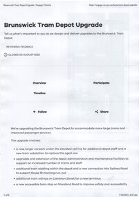 Melbourne Tram Museum
Document, Public Transport Victoria (PTV), Brunswick Tram Depot upgrade, 7-7-2022
Consultation document for the upgrade redevelopment of Brunswick tram depot including the provision of a super stop in Moreland Road. Outlines the proposal and provides a plan. When first published had a tram track extension along Moreland Road, but this was later removed.Yields information about the proposed upgrade of Brunswick Tram depot 2022Five A4 page consultative document, about the upgrade of Brunswick Tram Depot. Only 5 of the 9 pages collected.tramways, brunswick depot, trackwork, sydney road -
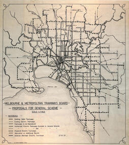 Melbourne Tram Museum
Drawing, Robert Green, Melbourne and Metropolitan Tramways Board Proposals for General Scheme, 2-1968
Drawing prepared by Robert Green for the TMSV showing the MMTB Proposals for tramway construction in the Melbourne Metropolitan Area. Traced and redrawn from the original drawing dated 27-8-1923. Shows the proposed tram lines submitted to Parliament for the report into the General Scheme as required by the MMTB Act when it was formed. See items 2088 for the original report and 2089 for a coloured print of this plan. Demonstrates the MMTB General scheme and a copy that could be used to produce further copies.Drawing - ink on mylar film.trams, tramways, mmtb, general scheme, development, parliamentk, map -
 Merbein District Historical Society
Map, Merbein Drainage Proposed Layout Plan No 65-D-1 (3 parts), unknown
... Drainage Proposed Layout Plan No 65-D-1 Merbein Drainage Proposed ...drainage proposed layout plan no 65-d-1 -
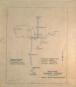 Ballarat Tramway Museum
Drawing - Proposed Fares, State Electricity Commission of Victoria (SECV), "Ballaarat Tramway System", 1949
The plan prepared by the SECV shows proposed fares, an increase of 1d on existing fares, and the through routing of tram services. Scale of 40 chains to 1". Alligns with August 1949 Fare By-Law - see item 3111. See also the pdf file "Ballarat Tramway Fares Changes SEC Era", by Warren Doubleday, 03-09-2006.Demonstrates aspects of the way the SEC prepared plans showing tram and ticketing arrangements.Plan titled "Ballaarat Tramway System" - multi-coloured on paper with pencil notations.tramways, ballarat, secv rules, by-laws, tickets, fares -
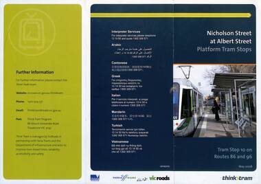 Melbourne Tram Museum
Pamphlet, VicRoads, "Nicholson Street at Albert Street Platform Tram Stops", May 2008
... Stops" - includes a plan of the proposed work, timing..." - includes a plan of the proposed work, timing, and benefits ...Pamphlet - "Nicholson Street at Albert Street Platform Tram Stops" - includes a plan of the proposed work, timing, and benefits of the installation. May 2008.Yields information about the installation of super stops at Nicholson and Albert Sts.Pamphlet - 3 fold DL full colourtrams, tramways, super stops, platform stops, planning, construction, nicholson st, albert st -
 Melbourne Tram Museum
Pamphlet - Real estate sale, T M Burke, "New Suburban line - Darling to Glen Waverley", July 1926
Pamphlet advising potential land purchasers of the recommendation to extend the railway line from Darling to Glen Waverley, extracted from The Age 26/6/1926. Advises that the land and losses would be paid for by the residents through their rates. Gives costs of the proposed new line. Has a plan showing the estates for sale along the line, the Ashburton line (later extended to Alamein) and Burwood Road. Published by T M Burke Pty Ltd. Demonstrates the style of land sale pamphlet including the proposed availability of train services to prospective purchasers.Pamphlet - single quarto sheet with map on rear - printed.sale of land, real estate, railways, glen waverley, suburban railways -
 Bacchus Marsh & District Historical Society
Map, Tracing of plan shewing portion through Bacchus Marsh District of proposed new Main Road between Gisborne and Blackwood
Road construction and planning was a primary function of the early local government authorities in rural and regional Victoria. This plan is indicative of the sort of documentation which generated considerable public interest and comment in rural communities. The date of this plan is not clear. Newspaper articles in the Bacchus Marsh Express around 1869 contain numerous references to the proposed new road between Gisborne and Blackwood which suggests this plan may date from the late 1860s or early 1870s.A single page paper map showing the proposed route of a main road to be constructed between Gisborne and Blackwood. The map is pasted into a bound volume containing 76 maps or plans in total. High resolution digital image stored on BMDHS computer network. roads, road plans, bacchus marsh victoria maps, gisborne to blackwood main road -
 Merri-bek City Council
Ceramic - Ceramic, acrylic paint, gold lustre and mix media, Bundit Puangthong et al, FOOD, 2018
These captivating pieces are part of a series called "FOOD / FLESH / FAME," a collaborative effort between Melbourne-based Thai artists Bundit Puangthong and Vipoo Srivilasa. Drawing from Buddhist teachings, the series explores the three elements of attachment: Food (consumption), Flesh (sex), and Fame (power). Although these elements are known to cause suffering, they remain persistently alluring, a paradox that the artists intend to explore further in the future. In creating these pieces, Vipoo Srivilasa initiated the process by sculpting three figures with bare surfaces. Bundit Puangthong then added his artistic touch by painting each sculpture. The artists' conceptual visions harmonized perfectly, especially considering their shared commitment to Buddhist principles, which frequently inspire their respective artistic practices. After Bundit completed his painting, Vipoo enlivened the pieces by adding eyes to the figures. He also embellished the works with pom-poms, lending them a softness that makes them appear both approachable and innocent, despite the weightiness of their themes. Each sculpture embodies a specific teaching from Buddhism: "FOOD" depicts a durian, the king of fruits, painted by Bundit Puangthong. He notes, "Despite its pungent aroma, many people still love to eat it."Donated the by the artists -
 Merri-bek City Council
Ceramic - Ceramic, acrylic paint, gold lustre and mix media, Bundit Puangthong et al, FLESH, 2018
In creating these pieces, Vipoo Srivilasa initiated the process by sculpting three figures with bare surfaces. Bundit Puangthong then added his artistic touch by painting each sculpture. The artists' conceptual visions harmonized perfectly, especially considering their shared commitment to Buddhist principles, which frequently inspire their respective artistic practices. After Bundit completed his painting, Vipoo enlivened the pieces by adding eyes to the figures. He also embellished the works with pom-poms, lending them a softness that makes them appear both approachable and innocent, despite the weightiness of their themes. Each sculpture embodies a specific teaching from Buddhism: "FLESH" features a golden umbrella, serving as a metaphor for sex. -
University of Melbourne, Burnley Campus Archives
Plan, MIFS Display for University of Melbourne Layout Plan Scale 1:50, 1997 - 2003
1& 2. MIFS Display for University of Melbourne Layout Plan (2003). 3. Design Concept MIFGS University of Melbourne Burnley College (2002). 4.MIFGS Burnley College Display (1997). 5. University of Melbourne Dept. of Environmental Horticulture & Resource Management Proposed MIFGS Display (1997)garden design, melbourne international flower and garden show, burnley college, michael green -
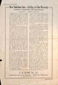
 Friends of Ballarat Botanical Gardens History Group
Plan - Proposed Entrance to Gardens; Clegg and Morris Architects, Melbourne and Ballarat
... Architects, Melbourne and Ballarat Plan Proposed Entrance to Gardens ...Shows proposed elevations and sections of proposed structureHistoricPhotocopy ballarat botanical gardens, buildings, plan, entrance -
 Flagstaff Hill Maritime Museum and Village
Document - Plan, Victorian Harbours Warrnambool, Victorian Harbours, Warrnambool, Plan to Accompany Sir John Coode's Report, 28-02-1879
... on the Victorian Heritage Database. This plan of the proposed works ...This plan is of great significance to the local history of Warrnambool, in particular the Breakwater and its impact on Warrnambool's maritime and trade history. The plan shows the existing jetties at the Port of Warrnambool, plus the partially erected Breakwater and proposed works to the Breakwater by both the Borough of Warrnambool Surveyor and Sir John Coode. The plan was signed 28th February 1879 by Sir John Coode. The legend at the bottom left describes the existing works and the proposed works. The Warrnambool Breakwater Sir John Coode was a British harbour engineer. He was brought to Melbourne by the Melbourne Harbour Trust to advise on works to improve the Port of Melbourne. The Victorian Government commissioned him to present a plan to complete the Warrnambool Breakwater. His original plan was too expensive so he prepared a revised plan for a shorter structure. The work was completed in 1890. The construction proved to be too short to protect adequately from the weather and didn't allow enough depth for larger vessels to come into port. The decreasing trade was further affected by siltation in the bay due to the breakwater, and the completion of the railway line. The situation of the harbour became a real problem that, by 1910, required continuous dredging. In 1914 the Breakwater was extended but proved to be a failure because the work began to subside and by 1920 about two thirds of the harbour was silted up. Alterations made in the 1920's increased the silting problem and by the 1940's the harbour was no longer used. More alterations were made in the 1950's and 1960's. The Warrnambool Breakwater is registered as a place of significance on the Victorian Heritage Database. This plan of the proposed works for the existing Warrnambool Breakwater is of great significance to the local history of Warrnambool, in particular the Breakwater and its impact on Warrnambool's maritime and trade history. The Warrnambool Breakwater is registered as a place of significance on the Victorian Heritage Database (VHR H2024). It is historically significant to Victoria as one of the most important maritime engineering projects in Victoria in the late 19th century. The Warrnambool Breakwater is of historical significance as one of the most important maritime engineering projects in Victoria in the late nineteenth century. It is evidence of Victoria's nineteenth century investment in regional port infrastructure and the development of Victorian coastal shipping. It is of significance for its association with the English civil engineer Sir John Coode, the most distinguished harbour engineer of the nineteenth century, who was brought to Victoria to advise on works to improve the Port of Melbourne, but was retained by the Government to advise on improvements to the harbours at Portland, Geelong, Port Fairy, and Lakes Entrance, as well as Warrnambool. His projects for Melbourne, Lakes Entrance and Warrnambool were major engineering projects of the nineteenth century. The breakwater is historically significant as a reminder of Warrnambool's early maritime history as a Western District port, and as one of Victoria's major 'outer ports'. While the Warrnambool Breakwater is a demonstration of the engineering skills of the nineteenth century, it also demonstrates the limitations of knowledge relating to sedimentology at the time and the confidence apparent in a number of nineteenth century plans which assumed that natural forces could be overcome or contained by engineering.Plan of Warrnambool Harbour, Port of Warrnambool, dated 28 Feb 1879. Plan shows existing Breakwater and work proposed by both Warrnambool Borough Surveyor and Sir John Coode. Plan has gold coloured quarter-dowel rods top and bottom and a metal ring at the top. Stamped with title. Signed by Sir John Coode.Stamped "VICTORIAN HARBOURS / WARRNAMBOOL / PLAN / to accompany / SIR JOHN GOODE'S REPORT / DATED 28 FEB 1879" Signature "John Coode"flagstaff hill, warrnambool, maritime museum, shipwreck coast, great ocean road, sir john coode, borough of warrnambool surveyor, plan of warrnambool, victorian harbours, warrnambool harbour, warrnambool breakwater, port of warrnambool, vhd vhr h2024, flagstaff hill maritime museum & village, maritime village, map, chart, plan, lady bay, breakwater, jetty, pier, vhr h2024, proposed works, 1879 -
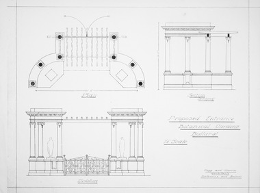
University of Melbourne, Burnley Campus Archives
Plan, Plan showing proposed adjustment of boundaries of the Horticultural Society's Gardens in Richmond Park, c.1880-1884
... Yarra Copy of B92.0535 framed and glazed. Plan showing proposed ...Copy of B92.0535 framed and glazed.gardens, richmond, hoticultural society of victoria, river yarra -
University of Melbourne, Burnley Campus Archives
Plan, John S. Jenkins, Plan showing land required for Road Purposes from the temporary reservaton for Horticultural Gardens at Richmond, 1880
Plan drawn by hand on tracing paper by John S. Jenkins, Town Surveyor, Richmond. "The land required is coloured red & it is proposed to add the part of Swan Street coloured blue to the gardens." Plan depicts land required for road purposes from the temporary reservation for Horticultural Gardens at Richmond. (Also framed and glazed copy B92.0539.) Scanned on CD.john s. jenkins, gardens, richmond, hoticultural society of victoria -
 University of Melbourne, Burnley Campus Archives
Plan, John S. Jenkins, Plan showing proposed adjustment of boundaries of the Horticultural Society's Gardens in Richmond Park, c.1880-1884
... for Centenary Exhibition - B92.0540.) Plan showing proposed adjustment ...Plan on linen fibre cloth. Shows layout of Burnley bound by Swan St., Yarra River and part of Richmond Park, coloured areas showing proposed area to be added to Park, the old road, shrubbery, new hall, old garden, recent extension and proposed further extension (crossed out in red ink). Scale 4 chains:1 inch. Probably drawn by John S. Jenkins, Town Surveyor, Richmond. Has been photographed so that additional copies can be made. On a CD plus 3 negatives, plus small coloured print. (Also copy glazed and framed for Centenary Exhibition - B92.0540.)john s. jenkins, gardens, richmond, hoticultural society of victoria -
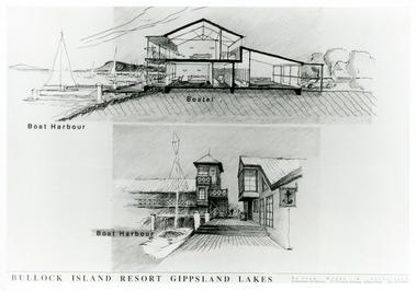 Lakes Entrance Historical Society
Photograph - Bullock Island, Lakes Post Newspaper, 1991
Date made September 1991Black and white photograph of the concept plans for the boat harbour of the proposed tourism facility on Bullock Island, Lakes Entrance, Victoria.Bullock Island Resort Gippsland Lakes islands, commercial development -
 Falls Creek Historical Society
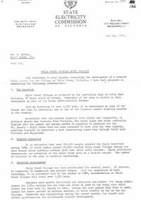
Document - SEC Information related to Tourist Hotel Project
Bob (Herman) Hymans (a former member of the Royal Netherlands Navy) was born in Bloemendaal, Holland on 30th September 1922. During World War II he fought against the Japanese in the Dutch East Indies (now Indonesia) and was imprisoned in Changi and on the Burma Railway. After gaining qualifications as a Ski Instructor, Bob arrived in Falls Creek in July 1950. Working as an Instructor and Supervisor at Bogong Lodge, Bob decided his future was in accommodation. He was successful in negotiating an indenture for land from the State Electricity Commission (SEC). It took Bob two years to build his Grand Coeur Chalet but, tragically, it was burned down in August 1961. Bob also built the first Chairlift in Australia. This was a single chairlift and the structure was built from wooden electricity poles. He was constantly full of new ideas and proposals for the village. Bob Hymans died on 7th July 2007. This Collection of documents and letters tells the story of Bob's endeavours to develop Falls Creek into the ski village it is today.This item is significant because it documents proposals put forward by Bob Hymans to develop facilities in the Falls Creek Tourist Area.A letter from the SEC to Mr Hymans outlining information related to the Falls Creek Tourist Hotel Project. Topics covered include: Tourist Potential; Existing Development in the area; information regarding the Site For Development; Liquor Licence; Lease; Process for submission of applications & Designs; References Required; Inspection Recommended prior to application. A general Plan & Aerial Photo of the proposed site was enclosed.falls creek tourist area management committee, falls creek administration, sewerage system falls creek -
 Falls Creek Historical Society
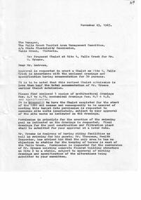
Document - Proposed Chalet At Site 4
Bob (Herman) Hymans (a former member of the Royal Netherlands Navy) was born in Bloemendaal, Holland on 30th September 1922. During World War II he fought against the Japanese in the Dutch East Indies (now Indonesia) and was imprisoned in Changi and on the Burma Railway. After gaining qualifications as a Ski Instructor, Bob arrived in Falls Creek in July 1950. Working as an Instructor and Supervisor at Bogong Lodge, Bob decided his future was in accommodation. He was successful in negotiating an indenture for land from the State Electricity Commission (SEC). It took Bob two years to build his Grand Coeur Chalet but, tragically, it was burned down in August 1961. Bob also built the first Chairlift in Australia. This was a single chairlift and the structure was built from wooden electricity poles. He was constantly full of new ideas and proposals for the village. Bob Hymans died on 7th July 2007. This Collection of documents and letters tells the story of Bob's endeavours to develop Falls Creek into the ski village it is today.This item is significant because it documents proposals put forward by Bob Hymans to develop facilities in the Falls Creek Tourist Area.A letter from J. Dale Fisher, an architect acting on behalf of Mr Hymans. The letter accompanied plans submitted to the SEC and the Management Committee for approval of the development of SIte 4, Christie Street, Falls Creek. The plans had been modified in response to earlier concerns related to cost. The new chalet would provide accommodation and a swimming pool and stables. Mr Hymans aimed to build a chalet which operated year round and would rival any of the resorts in New South Wales.falls creek tourist area management committee, bob hymans, falls creek administration