Showing 694 items
matching reef mining
-
 Bendigo Historical Society Inc.
Document - Great Extended Hustlers ,Hustlers Reef, Bendigo, April, 2014
Seven men were killed at the Great Extended Hustler's mine disaster on 2nd May 1914 by an explosion of dynamite occurring as the men were waiting at the plat to ascend the mine at the end of their shift. No blame was attached to anyone in the findings of the inquisition. It was unknown what caused the dynamite to explode. This document formed part of the research done at the time by Bendigo Historical Society, of the 100 years commemoration of the mine disaster, held at Hustler's Hill in 2014. Two page photocopy of article on the Great Extended Hustler's Reef Q.M. Co. Company formed in 1865 and area known as 'the first spot in Bendigo at which quartz had been systemically mined for gold'.great extended hustlers, goldmining, accident, 1873, david bannear, quartz, mining -
 Bendigo Historical Society Inc.
Photograph - Napoleon Reef Gold Mine Battery Site, 1936
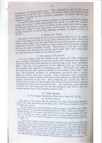
The Napoleon (BML) gold mine (1932) was located beside McDougall Road, Golden Gully, between Martin and Hattam Street. It had a depth of 921 feet. It was one of the latest and most lavish of Bendigo's mines. Plant and equipment were electrically driven. The four-compartment shaft, extra large by goldfield's standards, measured 17 feet 6 inches by 5 feet 2 inches and was cement lined below 900 feet instead of being red gum boxed as was the usual practice. The workshop was equipped to carry out all repairs for the equally lavish BML mines on the Nell Gwynne and Carshalton reefs. (The Gold Mines of Bendigo, Book 2, Arthur Victor Palmer)Significant to mining history of Bendigo.Black and white photograph. Image shows flat, open landscape with four large eucalypt trees in centre of image. Four men working with shovels on left hand side of image, one man with wheelbarrow and dog alongside. Wooden framed structure on right hand side. Written in pencil on back of photograph: ' Battery excavations started 22/9/36' and 'excavations started'.napoleon gold mine, napoleon reef gold mine -
 Bendigo Historical Society Inc.
Photograph - Napoleon Mine Battery, 1936
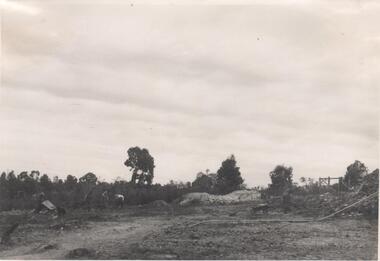
The Napoleon (BML) gold mine (1932) was located beside McDougall Road, Golden Gully, between Martin and Hattam Street. It had a depth of 921 feet. It was one of the latest and most lavish of Bendigo's mines. Plant and equipment were electrically driven. The four-compartment shaft, extra large by goldfield's standards, measured 17 feet 6 inches by 5 feet 2 inches and was cement lined below 900 feet instead of being red gum boxed as was the usual practice. The workshop was equipped to carry out all repairs for the equally lavish BML mines on the Nell Gwynne and Carshalton reefs. (The Gold Mines of Bendigo, Book 2, Arthur Victor Palmer)Significant to mining history of Bendigo.Black and white photograph: landscape view of mine sheds. Battery shed fully completed with trestleway to another shed. Trees in background. Written in pencil on back of photograph: 'completed battery 5/12/36'napoleon gold mine, napoleon reef gold mine -
 Bendigo Historical Society Inc.
Photograph - Napoleon Reef Gold Mine Battery Site, 1936
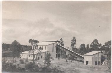
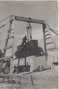
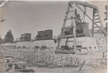
The Napoleon (BML) gold mine (1932) was located beside McDougall Road, Golden Gully, between Martin and Hattam Street. It had a depth of 921 feet. It was one of the latest and most lavish of Bendigo's mines. Plant and equipment were electrically driven. The four-compartment shaft, extra large by goldfield's standards, measured 17 feet 6 inches by 5 feet 2 inches and was cement lined below 900 feet instead of being red gum boxed as was the usual practice. The workshop was equipped to carry out all repairs for the equally lavish BML mines on the Nell Gwynne and Carshalton reefs. (The Gold Mines of Bendigo, Book 2, Arthur Victor Palmer)Significant to mining history of Bendigo.Black and white photograph of a stamper head being lowered into position on the battery site of the Napoleon Reef Gold Mine. A wooden gantry supports the battery head as it being lowered, a man is standing on top of the stamper head. Concrete foundations are visible in immediate background. napoleon gold mine, napoleon reef gold mine -
 Bendigo Historical Society Inc.
Photograph - Napoleon Mine Battery, 1936
The Napoleon (BML) gold mine (1932) was located beside McDougall Road, Golden Gully, between Martin and Hattam Street. It had a depth of 921 feet. It was one of the latest and most lavish of Bendigo's mines. Plant and equipment were electrically driven. The four-compartment shaft, extra large by goldfield's standards, measured 17 feet 6 inches by 5 feet 2 inches and was cement lined below 900 feet instead of being red gum boxed as was the usual practice. The workshop was equipped to carry out all repairs for the equally lavish BML mines on the Nell Gwynne and Carshalton reefs. (The Gold Mines of Bendigo, Book 2, Arthur Victor Palmer)Significant to mining history of Bendigo.Black and white photograph: battery shed under erectionWritten in pencil on back of photograph: 'battery erection 17/1`1/36' and 'cracker station building' napoleon gold mine, napoleon reef gold mine -
 Bendigo Historical Society Inc.
Photograph - Napoleon Mine Battery, 1936
The Napoleon (BML) gold mine (1932) was located beside McDougall Road, Golden Gully, between Martin and Hattam Street. It had a depth of 921 feet. It was one of the latest and most lavish of Bendigo's mines. Plant and equipment were electrically driven. The four-compartment shaft, extra large by goldfield's standards, measured 17 feet 6 inches by 5 feet 2 inches and was cement lined below 900 feet instead of being red gum boxed as was the usual practice. The workshop was equipped to carry out all repairs for the equally lavish BML mines on the Nell Gwynne and Carshalton reefs. (The Gold Mines of Bendigo, Book 2, Arthur Victor Palmer)Significant to mining history of Bendigo.Black and white photograph: battery under construction, concrete bottom blocks being 'boxed' up .Written in pencil on back of photograph: 'another new daring creation' and ' boxing the foundation 7/10/36'.napoleon gold mine, napoleon reef gold mine -
 Bendigo Historical Society Inc.
Photograph - Napoleon Reef Gold Mine Battery Site, 1936
The Napoleon (BML) gold mine (1932) was located near McDougall Road, Golden Gully, between Martin and Hattam Street. It had a depth of 921 feet. It was one of the latest and most lavish of Bendigo's mines. Plant and equipment were electrically driven. The four-compartment shaft, extra large by goldfield's standards, measured 17 feet 6 inches by 5 feet 2 inches and was cement lined below 900 feet instead of being red gum boxed as was the usual practice. The workshop was equipped to carry out all repairs for the equally lavish BML mines on the Nell Gwynne and Carshalton reefs. (The Gold Mines of Bendigo, Book 2, Arthur Victor Palmer) 'Napoleon BML Mines No Liability have issued a report for the fortnight ended September 5, where it states that the development scheme has been formulated and necessary equipment is being ordered. The Napoleon main shaft, (about 1700 feet south of the old Napoleon shaft) will be a four compartment shaft (17ft 6 inches by ft 2 inches inside the timber). aLevels will be opened at approximately 100 ft vertical intervals and cross-cuts extended approximately 125 ft each side of centre country to explore a cross-section across the anticline opposite to the shaft. At every fifth level, main drives will be extended north to connect with the old Napoleon shaft and south approximately 1800 ft. At the latter point, another cross-section of the anticline will be explored by rising and cross-cutting. The old Napoleon will be unwatered and on the 500ft and 1000 ft levels main drives will be driven to connect with main levels from the Napoleon main shaft to the south as well as being driven north 1800 ft where another cross-section of the anticline will be explored. Cross-sections further north and south may be developed as desired and also at intermediate points if necessary. Clearing and grading of the main shaft site are now in progress and the erection of the office and store building is proceeding. The design of engine room, change house and machine shops is now in hand and erection will proceed as soon as working plans and specifications are prepared.' The main shaft has been commenced at 3ft and advanced 10 ft. to 13 ft. https://trove.nla.gov.au/newspaper/article/10975478?searchTerm=napoleon%20bml (The Argus, 8th. September 1934, 'Mining' page 18) Significant to mining history of Bendigo.Black and white photograph of a stamper head being lowered into position on the battery site of the Napoleon Reef Gold Mine. A wooden gantry supports the battery head as it being lowered. Three large concrete foundations are visible in immediate background, two of which have stampers already in position, the third stamper is being lowered onto the final foundation. In immediate foreground, 'boxing' is erected for future concrete pours. napoleon gold mine, napoleon reef gold mine -
 Bendigo Historical Society Inc.
Plan - Mining Lease No. 10970, April, 2014
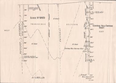
One page plan of Lease No. 10970, showing Napoleon Anticline and Central Nell Gwynne Shaft. Prepared by J. Caldwell, Mines Department Bendigo 6.2.1940.goldmining, quartz, mining, central nell gwynne gold mine, napoleon reef -
 Bendigo Historical Society Inc.
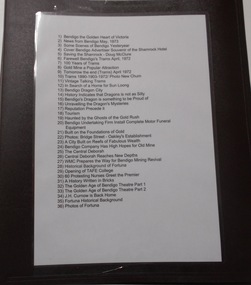
Newspaper - NEWSPAPER COLLECTION: BENDIGO ADVERTISER VARIOUS ARTICLES
1) Bendigo the Golden Heart of Victoria 2) News from Bendigo May, 1973 3) Some Scenes of Bendigo Yesteryear 4) Cover Bendigo Advertiser Souvenir of the Shamrock Hotel 5) Saving the Shamrock - Doug McClure 6) Farewell Bendigo's Trams April, 1972 7) 100 Years of Trams 8) Gold Mine a Popular Attraction 9) Tomorrow the end (Trams) April 1972 10) Trams 1890-1903-1972/ Photo New Chum 11) Vintage Talking Trams 12) In Search of a Home for Sun Loong 13) Bendigo Dragon City 14) History Indicates that Dragons is not as Silly 15) Bendigo's Dragon is Something to be Proud of 16) Unravelling the Dragon's Mysteries 17) Reputation Precede it 18) Tourism 19) Haunted by the Ghosts of the Gold Rush 20) Bendigo Undertaking Firm Installs Complete Motor Funeral Equipment 21) Built on the Foundations of Gold 22) Photos: Bridge Street - Oakley's Establishment 23) A City Built on reefs of Fabulous Wealth 24) Bendigo Company Has High Hopes for Old Mine 25) The Central Deborah 26) Central Deborah Reaches New Depths 27) WMC Prepares the Way for Bendigo Mining Revival 28) Historical Background of Fortuna 29) Opening of TAFE College 30) 60 Protesting Nurses Greet the Premier 31) A History Written in Bricks 32) The Golden Age of Bendigo Theatre Part 1 33) The Golden Age of Bendigo Theatre Part 2 34) J.H. Curnow is Back Home 35) Fortuna Historical Background 36) Photos of Fortuna. Folder 110 now in Box 417. AV 03/11/2022bendigo, goldfields, tourism, history -
 Bendigo Historical Society Inc.
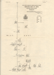
Map - HUSTLER'S REEF & HUSTLER'S REEF NO 1 MINES - PLAN OF THE HUSTLER'S REEF & HUSTLER'S REEF NO 1 MINES
... MINING Parish Map Hustler's Reef & Hustler's Reef No 1 ...Plan of the Hustler's Reef & Hustler's Reef No 1 Mines on the Hustler's Line of Reefs, Bendigo Bulletin No 33, Plate No XIV. No 8 connecting No 10 (Hustler's Reef), No 11 connecting No 13 (Hustler's Reef), No 13 (Hustler's Reef No 1) connecting No 15 (Hustler's Reef) and No 10 Hustler's Reef No 1 rise to Comet Mine. Map shows different levels in relation to the two shafts, the lines of the Hustler's Line of Reefs and the Lightning Hill Line of Reefs, the approximate Boundary of Lease and the Comet Co., the adjoining lease. Table on the left shows the levels and their depths of the two mines. Signed by H A Whitelaw, Underground Survey Office, Bendigo, September 1913. Geological Survey of Victoria emblem. mining, parish map, hustler's reef & hustler's reef no 1 mines, hustler's line of reefs lightning hill line of reefs, comet co., h a whitelaw, underground survey office bendigo, geological survey of victoria -
 Bendigo Historical Society Inc.
Map - HUSTLER'S REEF & HUSTLER'S REEF NO 1 MINES - LONGITUDINAL SECTION OF THE HUSTLER'S REEF & HUSTLER'S
... MINING Parish Map Hustler's Reef & Hustler's Reef No 1 ...Longitudinal Section of the Hustler's Reef & Hustler's Reef No 1 Mines on the Hustler's Line of Reef. Bulletin No 33, Plate No XX. Note - Plates 4, 8, 13, 20, 26 & 31 form a Longitudinal Section from Fortuna Hustler's to Hustler's Consols Mine. Geological Survey of Victoria emblem. Signed by H A Whitelaw, Underground Survey Office Bendigo, September 1913. Shows the two shafts with their levels and depths. Also shows geographical features and yields of gold and amalgam per ton. .mining, parish map, hustler's reef & hustler's reef no 1 mines, geographical survey of victoria, underground survey office bendigo, h a whitelaw -
 Bendigo Historical Society Inc.
Map - HUSTLER'S REEF & HUSTLER'S REEF NO 1 MINES - PLAN OF THE HUSTLER'S REEF & HUSTLER'S REEF NO 1 MINES
... MINING Parish Map Hustler's Reef & Hustler's Reef No 1 ...Plan of the Hustler's Reef & Hustler's Reef No 1 Mines on the Hustler's Line of Reefs Bulletin No 33, Plate No XVII. Two drawings with different levels on each for clarity. Shows depth and some geographical features. Geological Survey of Victoria emblem. Signed by H A Whitelaw Underground Survey Office Bendigo, September 1913. mining, parish map, hustler's reef & hustler's reef no 1 mines, hustler's line of reefs, geological survey of victoria, underground survey office bendigo, h a whitelaw -
 Bendigo Historical Society Inc.
Map - HUSTLER'S REEF & HUSTLER'S REEF NO 1 MINES - PLAN OF THE HUSTLER'S REEF & HUSTLER'S REEF NO 1 MINES
... MINING Parish Map Hustler's Reef & Hustler's Reef No 1 ...Plan of the Hustler's Reef & Hustler's Reef No 1 Mines on the Hustler's Line of Reefs Bulletin No 33, Plate No XV. Plan shows the two mines with depth of levels, geological features and levels in relation to the shaft. Geological Survey of Victoria emblem and signed by H A Whitelaw, Underground Survey Office Bendigo, September 1913. Note - The Lease Boundaries shown on this plan are only in their approximate relative positions to Nos 13, Intermediate and 14 Levels of the Hustler's Reef No 1 workings, and Nos 15, 16 and 17 Levels of the Hustler's Reef workings.mining, parish map, hustler's reef & hustler's reef no 1 mines, geological survey of victoria, underground survey office bendigo, h a whitelaw, hustler's line of reefs -
 Bendigo Historical Society Inc.
Map - HUSTLER'S REEF NO 1 MINE - EAST & WEST CROSS-CUTS OF THE HUSTLER'S REEF NO 1 MINE
... MINING Parish Map Hustler's Reef No 1 Mine Geological ...Map showing the East & West Crosscuts, North & South of Shaft of the Hustler's Reef No 1 Mine on the Hustler's Line of Reefs Bulletin No 33, Plate No XXII. Drawing shows where the different levels are, the stone encountered and smaller drawings of other sections near the shaft. Also shows some geographical features. Signed by H A Whitelaw, Underground Survey Office Bendigo, September 1913. Geological Survey of Victoria emblem.mining, parish map, hustler's reef no 1 mine, geological survey of victoria, h a whitelaw, underground survey office bendigo, hustler's line of reefs -
 Bendigo Historical Society Inc.
Map - HUSTLER'S REEF & HUSTLER'S REEF NO 1 MINES - PLAN OF THE HUSTLER'S REEF & HUSTLER'S REEF NO 1 MINES
... MINING Parish Map Hustler's Reef & Hustler's Reef No 1 ...Plan of the Hustler's Reef & Hustler's Reef No 1 Mines on the Hustler's Line of Reefs, Bendigo Bulletin No 33, Plate No XVI. Plan shows the two shafts and the levels in relation to it. No 9 Level 896 feet 9 inches connecting No 10 Level at 867 feet 2 inches. Plan shows depth of levels and geographical features. Signed by H A Whitelaw, Underground Survey Office, Bendigo. Geographical Survey of Victoria emblem.mining, parish map, hustler's reef & hustler's reef no 1 mines, hustler's line of reefs, h a whitelaw, underground survey office bendigo, geographical survey of victoria -
 Bendigo Historical Society Inc.
Map - COMET MINE - LONGITUDINAL SECTION COMET MINE
Longitudinal section of the Comet Mine on the Hustler's Line of Reef Bulletin No 33, Plate No XXVI signed by H. S. Whitelaw, Underground Survey Office Bendigo, September 1913. Map shows datum lines, depths of levels, approximate boundaries and references to other plans. Note - Plates 4, 8, 13, 20, 26 and 31 form a Longitudinal Section from Fortuna Hustler's to Hustler's Consols Mine. Geological Survey of Victoriamining, parish map, hustler's line of reef, longitudinal section of comet mine bulletin no 33 plate no xxvi, h s whitelaw -
 Bendigo Historical Society Inc.
Map - COMET MINE - TRANSVERSE SECTION COMET MINE
... MINING Hustler's Line of Reefs Transverse Section of Comet ...Transverse section of the Comet Mine on the Hustler's Line of Reef Bulletin No 33, Plate No XXV signed by H. A. Whitdon, Underground Survey Office Bendigo September,1913. Map shows depth of the different levels, the type of stone and shaft about 2020 deep. A number of smaller drawings on the side. Reference explaining the different types of stone, etc. Geological Survey of Victoriamining, hustler's line of reefs, transverse section of comet mine bulletin no 33 plate no xxv, lightning hill line of reef -
 Bendigo Historical Society Inc.
Map - COMET MINE - PLAN OF COMET MINE
... MINING Hustler's Line of Reefs Comet Line Plan Belletin ...Plan of the Comet Mine on the Hustler's Line of Reefs Bulletin No 33, Plate No XXIII. Map shows depths, Lightning Hill Anticline, Hustler's Anticline and approximate Lease Boundary. Signed by H. S. Whitelaw, Underground Survey Office Bendigo, September 1913. United Hustler's & Redan Co and Hustler's Reef Co also named on map. Geological Survey of Victoriamining, hustler's line of reefs, comet line plan belletin no 33 plate no xxiii, lightning hill anticline, hustler's anticline, united hustler's & redan co, hustler's reef co, h s whitelaw -
 Bendigo Historical Society Inc.
Map - COMET MINE - PLAN OF COMET MINE
Plan of the Comet Mine on the Hustler's Line of Reefs Bulletin No 33, Plate No XXIV signed by H S Whitelaw, Underground Survey Office Bendigo, September 1913. Upper and Lower Levels and approximate boundaries shown. Depths shown.Geological Survey of Victoriamining, parish map, hustler's line of reefs, comet mine plan bulletin no 33 plate no xxiv -
 Bendigo Historical Society Inc.
Map - HUSTLERS LINE OF REEFS - LONGITUDINAL SECTION THROUGH THE SADDLE REEFS
... MINING hustler's reef maps Hustlers Line of Reefs Bendigo ...Drawing with Longitudinal Section through the Saddle Reefs along portion of Hustler's Line of Reefs, Bendigo. Map shows the depth of the mines, reef numbers and Datum 700 ft above sea level. North and South is also noted on the map. Map signed by H. S, Whitelaw, Underground Survey Office, Bendigo, September 1913. Bulletin No 33, Plate No XXXIV. Bendigo Creek, Ironbark Creek and Long Gully are also noted. Mines are: Fortuna Hustlers, Hustler's Royal Reserve No 2 Main Shaft, Hustler's Royal Reserve No 2 Park Shaft, Royal Hustler's, Imperial Hustler's, Extended Hustler's Freehold, Great Extended Hustler's Tribute (Pups), Old Shaft, Great Extended Hustler's Reef No 2, Great Extended Hustler's Main Shaft, Old Shaft, Hustler's Reef, Hustler's Reef No 1, Comet, K. K., United Hustler's & Redan, Old Shaft and Hustler's Consols. Has Geological Survey of Victoria Crest and underneath is: H. Herman, Director, W. Dickson, Secretary for Mines, The Hon. J Drysdale Brown M L C. Minister of Mines.Geological Survey of Victoria Crestmining, hustler's reef maps, hustlers line of reefs, bendigo creek, royal hustler's, imperial hustler's, extended hustler's freehold, great extended hustler's tribute (pups), great extended hustler's reef no 2, great extended hustler's main shaft, hustler's reef, hustler's reef no 1, united hustler's & redan, old shaft and hustler's consols.h s whitelaw, underground survey office bendigo september 1913 -
 Bendigo Historical Society Inc.
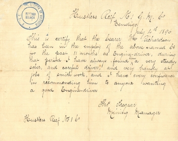
Document - HUSTLERS REEF MINE - REFERENCE FOR WM RICHARDSON
Handwritten reference for William Richardson. It mentions he has been employed as an engine driver and is very handy at smith work. Signed by Tho Tregear, Mining Manager from the Hustlers Reef No 1 G. M. Co. Dated July 4th, 1896. Blue stamp of Royal Historical Society of Victoria, Bendigo Branch in the top left corner. Also, another piece of paper mentioning William Richardson is the grandfather of Albert Richardson who wrote notes on mines.mine, gold, hustlers reef mine, william richardson, tho tregear -
 Bendigo Historical Society Inc.
Document - GREAT SOUTHERN MINE - NOTES ON THE GREAT SOUTHERN MINE
One copy of hand written and one copy of typed notes on the Great Southern Mine. Notes include Size of lease, Depth, Locality, Plant, Early History and Best Gold. Note on underground connection between the Great Southern 941 feet level to Ulster United 893 feet level. Reference: Mines Dept Special Edition Australian Mining Standard 1.6.1899, Mines Dept Booklet Bendigo Goldfield Geo Brown 1936, Mines Dept Quarterly and Annual Reports, Annals of Bendigo 1878 to 1915 Mining Sections, A Richardson, Catalogue Mining Sales J H Curnow 10.4.1947.mine, gold, great southern mine, garden gully line of reef, ulster united, a richardson -
 Bendigo Historical Society Inc.
Map - HUSTLER'S REEF NO 1 MINE - TRANSVERSE SECTION OF THE HUSTLER'S REEF NO 1 MINE
... MINING Parish Map Hustler's Reef No 1 Mine Hustler's Line ...Map of a transverse Section of the Hustler's Reef No 1 Mine on the hustler's Line of Reefs Bulletin No 33, Plate No XXI. Map shows poppet legs at 801.07 feet above Sea Level and drawing of shaft with the different levels. Also shown are geological features and stone encountered. Geological Survey of Victoria emblem H Herman, Director, W Dickson, Secretary of Mines and The Hon. J. Drysdale Brown MLC Minister of Mines. Signed by H S Whitelaw, Underground Survey Office Bendigo, September 1913. This item has not been scanned or photographed.mining, parish map, hustler's reef no 1 mine, hustler's line of reefs, geological survey of victoria, underground survey office bendigo, h s whitelaw, h herman, w dickson, the hon j drysdale brown -
 Bendigo Historical Society Inc.
Map - HUSTLER'S ROYAL RESERVE NO 2 CO. - LONGITUDINAL SECTION OF THE HUSTLER'S ROYAL RESERVE NO 2 CO
Longitudinal Section of the Hustler's Royal Reserve No 2 Co. on the Hustler's Line of Reef Bulletin No 33, Plate No VIII. Note - Plates 4, 8, 13, 20, 26 & 31 form a Longitudinal Section from Fortuna Hustler's to Hustler's Consols Mine. Mines mentioned are the Hustler's Royal Reserve No 2 Main Shaft, Hustler's Royal Reserve No 2 Park Shaft, Royal Hustler's, Imperial Hustler's, Great Extended Hustler's Freehold and the Great Extended. Section shows depth of levels, datum lines and height of sill above sea level yield in oz. of gold. Geological Survey of Victoria emblem. H. Herman, Director, W. Dickson, Secretary for Mines and The Hon. J. Drysdale Brown MLC, Minister for Mines and signed by H S Whitelaw, Underground Survey Office Bendigo, September 1913. mining, parish map, hustler's royal reserve no 2, royal hustler's, imperial hustler's, great extended hustler's freehold, great extended, geological survey of victoria, underground survey office bendigo, h s whitelaw, h herman, w dickson, the hon j drysdale brown -
 Bendigo Historical Society Inc.
Map - HUSTLER'S ROYAL RESERVE NO 2 MINE - PLAN OF THE HUSTLER'S ROYAL RESERVE NO 2 MINE
Plan of the Hustler's Royal Reserve No 2 Mine Bulletin No 33, Plate No V. Plan shows the Hustler's Royal Reserve No 2 (Main Shaft), Hustler's Royal Reserve No 2 (Park Shaft.), the Royal Hustler's, the Imperial Hustler's and the Extended Hustler's Freehold on the Hustler's Line of Reefs. Also mentioned is the Lightning Hill Line of Reefs. Map shows some of the levels, approximate boundary of lease and the boundary of Lease No 8892 and 8897. There are also street names and the locations of jail, lagoons, Post Office, Rosalind Park and the State School, High School and Continuation School. Geological Survey of Victoria emblem. H. Herman Director, W. Dickson, Secretary of Mines and The Hon. J. Drysdale Brown MLC, Minister of Mines. Signed by zh Whitdan, Underground Survey Office, Bendigo, September 1913.mining, parish map, hustler's royal reserve no 2 mine, royal hustler's, imperial hustler's, extended hustler's freehold, geological survey of victoria, h herman, w dickson, the hon j drysdale brown, h whitdan, hustler's line of reefs, lightning hill line of reefs -
 Bendigo Historical Society Inc.
Map - HUSTLER'S ROYAL RESERVE NO 2 MINE - PLAN OF THE HUSTLER'S ROYAL RESERVE NO 2 MINE
Plan of the Hustler's Royal Reserve No 2 Mine on the Hustler's Line of Reefs Bulletin No 33, Plate No VI. Boundary of Leases No 8898 and 8897 shown. Various levels shown and some geographical features. Geological Survey of Victoria emblem. H . Harman, Director, W. Dickson, Secretary for Mines and The Hon. J. Drysdale Brown, Minister of Mines and signed by H Whitdon, Underground Survey Office, Bendigo, September 1913. mining, parish map, hustler's royal reserve no 2 mine, hustler's line of reefs, geological survey of victoria, h herman, w dickson, the hon j drysdale brown mlc -
 Bendigo Historical Society Inc.
Map - HUSTLER'S ROYAL RESERVE NO 2 CO - TRANSVERSE SECTION OF THE HUSTLER'S ROYAL RESERVE NO 2 CO
Transverse Section of the Hustler's Royal Reserve No 2 Co Mine on the Hustler's Line of Reef Bendigo, Bulletin No 33, Plate No VII. Section shows the poppet legs and the sill of Shaft at 707.65 ft above sea level, depth of levels, stone encountered and geological features. Geological Survey of Victoria emblem. H. Herman Director, W. Dickson Secretary of Mines and The Hon. J. Drysdale Brown MLC, Minister of Mines. Signed by H S Whitelaw, Underground Survey Office Bendigo, September 1913. mining, parish map, hustler's royal reserve no 2 co, h s whitelaw, undergrou;nd survey office bendigo, geological survey of victoria, h herman, w dickson, the hon. j drysdale brown mlc -
 Bendigo Historical Society Inc.
Map - HUSTLER'S ROYAL RESERVE NO 2 (PARK SHAFT.) - TRANSVERSE SECTION OF THE HUSTLER'S ROYAL RESERVE NO 2
Transverse section of the Hustler's Royal Reserve, No 2 (Park Shaft.) on the Hustler's Line of Reef. Bulletin No 33, Plate No IX. Section shows poppet legs and sill of shaft at 755.70 ft above sea level, depth of levels, type of stone encountered including lava and geological features. Geological Survey of Victoria emblem and beneath it H. Herman, Director, W. Dickson, Secretary of Mines and The Hon. J. Drysdale Brown MLC Minister of Mines and signed by H S Whitelaw, Underground Survey Office, Bendigo September 1913.mining, parish map, hustler's royal reserve no 2 (park shaft.), h s whitelaw, underground survey office bendigo, geological survey of victoria, h herman, w dickson, the hon j drysdale brown mlc, hustler's line of reef -
 Bendigo Historical Society Inc.
Map - UNITED HUSTLER'S & REDAN & K. K. MINES - PLAN OF THE UNITED HUSTLER'S & REDAN & K. K. MINES
Plan of the United Hustler's & Redan & K. K. Mines Bulletin No 33 Plate No XXXI. Shows depth of levels, Probable positions of reefs and natural surface with the poppet legs at the two shafts. Sill of shaft of the K. K. Mine 773.56 ft above Sea Level and sill of shaft of the United Hustler's & Redan Mine 745.62 above Sea Level. Also mentioned is the average amount of gold obtained per ton. Note on the top of page - Plates 4, 8, 13, 20, 26 & 31 form a Longitudinal Section from Fortuna Hustler's to Hustler's Consols Mine. Geological Survey of Victoria emblem and signed by H S Whitelaw, Underground Survey Office, Bendigo, September 1913. mining, parish map, united hustler's & redan & k. k. mines, geological survey of victoria, h s whitelaw, underground survey office bendigo -
 Bendigo Historical Society Inc.
Map - UNITED HUSTLER'S & REDAN & K. K. MINES - PLAN OF UNITED HUSTLER'S & REDAN & K. K. MINES
Plan of the United Hustler's & Redan & K. K. Mines on the Hustler's Line of Reefs Bulletin No 33 Plate No XXVII. Plan shows depth of levels, Long Gully, Hustler's Line of Reefs, Lightning Hill Line of Reefs and approximate Boundary of Lease. Also mentions Comet Co. Geological Survey of Victoria emblem and signed by H S Whitelaw, Underground Survey Office Bendigo September 1913.mining, parish map, united hustler's & redan & k. k. mines, long gully, hustler's line of reefs, lightning hill line of reefs, comet co, h s whitelaw, geological survey of victoria, underground survey office