Showing 651 items matching "station reserve"
-
 City of Kingston
Photograph - Colour, 29 January 1993
Bonbeach is a small beachside suburb located between Chelsea and Carrum. The station was opened in 1926 and was the last to be established in the group from Aspendale to Carrum. Urban growth began after World War II. State primary and high schools were opened in 1958 on land in Breeze Street that was once occupied by The Australian Glass Manufacturers. Immediately east of the school sites is the Patterson River Golf Club. The Bonbeach sports reserve has five ovals and is home to the Bonbeach football and baseball clubs. The suburb borders the Edithvale-Seaford Wetlands which is the remnant site of the Carrum Carrum swamp, once the home of the Bunurong people.Bonbeach was originally a seaside destination for holidaymakers and the housing comprised of holiday homes and gradually more permanent residents. It was not until 1926 that Bonbeach had its own railway station. From 1906 until the late 1940s sand was quarried on the east side of the railway line and used in the manufacture of glass. The Australian Glass Manufacturers sold this land in residential blocks and Bonbeach's permanent population spread from the coastal strip across to the other side of the railway line. Laminated colour aerial photograph of the suburb of Bonbeach and also the southern section of neighbouring Chelsea within the City of Kingston. The extent of this 1993 aerial image includes: Top left - Maury Road at the south end of the Chelsea shopping Centre; Top right - Scotch Parade Chelsea Bottom left - Monica Avenue in Bonbeach; Bottom right - Patterson River Golf Club. Landmarks include St Joseph's Church and Primary School, Chelsea Primary School, Bonbeach Station, Bonbeach Fotball Club sports playing fields and Bonbeach Life Saving Club. The Edithvale Wetlands is featured prominently to the right-hand side of the image. Black typed writing on white adhesive label: No. 6662 Black typed writing on white adhesive label: 26E/6662, 29/1/93, 4.25 pm Black typed writing on white adhesive label: 29-1-93 Black typed writing on white adhesive label: P000109 Circular yellow adhesive sticker bonbeach, chelsea -
City of Kingston
Photograph - Colour, 6 March 1993
Edithvale is a suburb in the City of Kingston. It is located between Aspendale and Chelsea on the Port Phillip Bay and built within remnant areas of the Carrum Carrum swamp. The foreshore precinct comprises a wide sandy beach, with low sand dunes and numerous historic boat sheds. The suburb consists of older style dwellings and former holiday houses, combined with mid-century housing and newer homes. The large blocks are increasingly subdivided and the existing dwellings demolished to accommodate units and townhouses, thus changing the landscape of the area and reducing the tree canopy.The beachside suburb of Edithvale was previously part of the extensive Carrum Carrum Swamp. The area was once a source of fish and eels for the Mayone-Bulluk clan of the Bunurong people. Over time the area was drained and predominantly devoted to dairy farming and holiday houses. The farms were gradually sold and subdivided with a large number of homes built after World War II and in the 1960s. Edithvale is mainly residential with a shopping strip along Nepean Highway but little significant industry was ever established in the area apart from a plaster works and confectionary factory, both now closed.Laminated aerial colour photograph of Edithvale as viewed from Alexandra Avenue in the north to Ella Grove Chelsea/Edithvale in the south. regents Park Aspendale can be seen in the top left. The area is built-up with residential housing and facilities including Edithvale Primary School, numerous churches and the Edithvale Railway station. Large sections depict the remnant Carrum Carrum swamp. Edithvale Common and the former "Duck Inn" (Melbourne Water/Friends of Edithvale Seaford Wetlands) can be seen. Edithvale Recreational reserve, the valodrome and Edithvale Public Golf Course are prominent. The image shows vacant land in the area now known as Aspendale Gardens and the newer residential section of Chelsea Heights is not developed. A bike path has been established to cover the secondary drain. The Golf Links Court residential development located off Hughes Avenue is a large vacant block.Black type on white adhesive label: 6-3-93 Black type on white adhesive label: 25/9211, 6/3/93, 11.20 am Black type on white adhesive label: 9211 Yellow circular adhesive sticker Black pencil: 9211 6-3-93 arrow pointing Nedthvale, carrum carrum swamp, aspendale, chelsea -
 City of Kingston
Photograph - Black and white, 20 December 1945
This aerial photograph depicts the changing landscape of Cheltenham and Highett since WWII. Photographed in 1945, there is a mix of urban dwellings and industrial development and precedes the major transformation of Cheltenham with the development of the Southland shopping centre in the 1960s and expansion in the 1990s.A large part of Cheltenham was originally established as a rural market gardening community. The railway line and station brought urban development to the area and in the north, the Highett area was dominated by the Highett Gas Works. Cheltenham became a major destination for shopping in the 1960s with the opening of Southland.Aerial photograph taken in 1945 of Cheltenham and Highett within the City of Kingston. The image includes the Highett Reserve, (top right), the Methodist Children Homes (now Southland), Nepean Highway and Jamieson Street. Highett Gas Works is visible in the top left and the land now named William Fry Reserve at the intersection of Bay Road and Nepean Highway. A visible large parcel of land on the corner of Bay Road and Nepean Highway was developed in the 1990s as the west side addition to Southland. The densely vegetated area in the upper right sector of the image is now dense with housing. Tulip Grove, Heather Grove and Gilford Street are visible bottom left. This image is possibly from the collection of aerial photographs commissioned by the Department of Crown Lands and Survey and taken by Adastra Airways.Black ink: 57252 White lettering: VIC-10 57252 20.12.45 [lens information indecipherable] PROJ. No.5 MELB. METROP AREA Black pencil: 80highett, cheltenham, highett gas works, urbanisation -
 City of Kingston
Photograph - Black and white, 20 December 1945
This aerial photograph depicts the changing landscape of Cheltenham and Highett since WWII. Photographed in 1945, there is a mix of urban dwellings and industrial development and precedes the major transformation of Cheltenham with the development of the Southland shopping centre in the 1960s and expansion in the 1990s.A large part of Cheltenham was originally established as a rural market gardening community. The railway line and station brought urban development to the area and in the north, the Highett area was dominated by the Highett Gas Works. Cheltenham became a major destination for shopping in the 1960s with the opening of Southland.Aerial photograph taken in 1945 of Cheltenham and Highett within the City of Kingston. The image includes the Highett Reserve, (top right), the Methodist Children Homes (now Southland), Nepean Highway and Jamieson Street. Highett Gas Works is visible in the top left and the land now named William Fry Reserve at the intersection of Bay Road and Nepean Highway. A visible large parcel of land on the corner of Bay Road and Nepean Highway was developed in the 1990s as the west side addition to Southland. The densely vegetated area in the upper right sector of the image is now dense with housing. Tulip Grove, Heather Grove and Gilford Street are visible bottom left. This image is possibly from the collection of aerial photographs commissioned by the Department of Crown Lands and Survey and taken by Adastra Airways.Black type: Reverse lettering VIC-10 57252 20.12.45 [lens information indecipherable] PROJ. No.5 MELB. METROP AREA White lettering: Reverse writing 57252cheltenham, highett, highett gas works, urbanisation -
 Port Melbourne Historical & Preservation Society
Photograph - Elsie Nicholson with Fred and dog in Page Reserve, 1940s
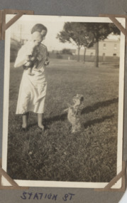
... Elsie Nicholson with baby Fred and dog in Page Reserve... NICHOLSON Dunstan parade Station Street Elsie NICHOLSON Page Reserve ...Fred Nicholson and his family originally lived at 208 Station St and later moved to 11 Dunstan Parade. Photos show him from baby to pre-teen and were mostly taken in the 1940sElsie Nicholson with baby Fred and dog in Page Reserve opposite 208 Station Street fred nicholson, dunstan parade, station street, elsie nicholson, page reserve -
Canterbury History Group
Document - Thematic Environmental History, Built Heritage, 1/05/2012
Thematic Environmental Heritage. Final document produced, after community consultation, for the City of Boroondara by Built Heritage242 pages city of boroondara, back yards, canterbury, churches, cottages, dairies, danks family, elgar survey, exploration, frognall, goldings boot factory, maling road, malone's hotel, maps, masonic lodges, national parks, native plants, outer circle railway line, police stations, post offices, railways, rochester road, schools, shrublands, soldiers memorial hall, sport, telephone exchanges, theatres, transport, wildlife, canterbury road, land subdivisions, parks and reserves -
 Sunbury Family History and Heritage Society Inc.
Photograph, Sunbury News Office, c1892
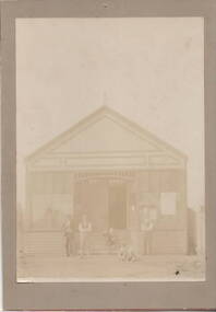
... the' Sunbury News' in this printing office which was on railway reserve... the' Sunbury News' in this printing office which was on railway reserve ...The building is the first Sunbury News Office that was owned by Arthur Boardman. In 1892 he began publishing the' Sunbury News' in this printing office which was on railway reserve near the station, which today is the bus terminal at Sunbury Station. The 'Sunbury News' was distributed throughout the Shire of Bulla and surrounding areas for almost 7 decades.A faded sepia non-digital photograph backed onto fawn coloured cardboard of a shop building with five people standing outside. sunbury news, arthur boardman -
 Whitehorse Historical Society Inc.
Article - The Bulletin article, The Bulletin, Mont Albert Railway Reserve, March-may 2021
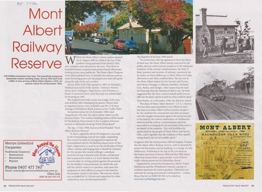
After the Mont Albert Railway Station opened in 1890, 50 ratepayers petitioned the Nunawading Council to oppose the sale of the railway reserve to the north in order for it to become a recreation reserve.After the Mont Albert Railway Station opened in 1890, 50 ratepayers petitioned the Nunawading Council to oppose the sale of the railway reserve to the north in order for it to be a recreation reserve.non-fictionAfter the Mont Albert Railway Station opened in 1890, 50 ratepayers petitioned the Nunawading Council to oppose the sale of the railway reserve to the north in order for it to become a recreation reserve.mont albert, railway stations, surrey hills golf club -
 Melbourne Tram Museum
Album - Robert Thomson Slide Collection, AETA Convention 1970
Photo - see pdf file for further information. Number Brief Description RT091 Burke Road Camberwell south of the Junction but before Inglesby St. W7 No. 1007 Destination "Special". RT092 Riversdale Road Camberwell Junction - SW6 No. 933 - "City" - route 70 RT093 Miller Street outside the Preston Workshops - W2 No. 597 - "City - Spencer St" - route 9A RT094 West Maribyrnong Terminus SW6 No. 927 - "City via North Melb." - route 57 plus Y class No. 469 - "City" RT095 Queens Way St. Kilda. PCC No. 980 - "Special" RT096 Reserve track running alongside River St. Maribyrnong Y class No. 469 west bound - "Hawthorn Depot" RT097 Footscray Terminus Leeds Street Y class No. 469 - "Special" RT098 Brunswick Depot - various trams including W3 No. 657 - W5 No. 755 "Moreland" route 20 & W5 No. 732 "Moreland" route 15. RT099 North Fitzroy Depot AETA - buses 543, 551 & 583 All AEC Mk 3's RT100 Port Melbourne Station with four car "Harris" set. RT101 St Kilda Station with four car "Harris" set. RT102 Preston Workshops W2 No. 397 - route 01 (01 overhaul) plus another W2 and a Y1 RT104 Preston Workshops, W5 No 681 - not long after a repaint. RT105 Preston Workshops, Freight car No. 19 RT106 Preston Workshops, various cars of different classes. nearest is W5 No. 793 Route 03 (03 overhaul) Demonstrates the work of Robert Thomson in photography, collection and/or production of slidesAssembled album in a black presentation folder of 16 colour slides, collected or produced by Robert Thomson. All photographs have been scanned and placed on the Museum's G drive. A list of all photographs with details has been compiled. melbourne, tramways, trams, aeta, mmtb, preston workshops, miller st, footscray, leeds st, burke rd, west maribyrnong, camberwell junction, brunswick depot, north fitzroy depot, buses, mmtb buses, aec mk iii, w2 class, w3 class, sw6 class, w7 class, w5 class, tram 793, tram 19, tram 1007, tram 681, tram 397, tram 657, tram 469, y class, tram 980, pcc class, queens way, tram 933, riversdale road, camberwell, tram 755, tram 732, bus 543, bus 551, bus 583, port melbourne railway, railways, route 70, route 57, route 15, route 20, route 9a -
 St Kilda Historical Society
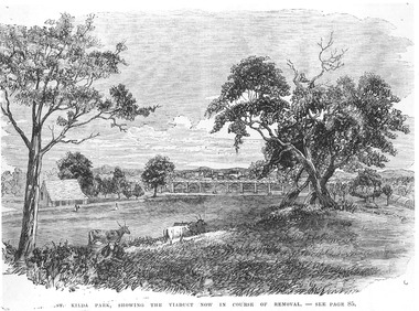
Photograph - Photograph of artwork, St Kilda Park, showing the viaduct now in course of removal, 25/06/1867
St Kilda Park, now Albert Park Reserve, showing cows, eucalyptus trees, oval and a railway viaduct in background. The viaduct was part of the Windsor to St Kilda loop line which operated between 1857 and 1867. The loop line ran from the St Kilda railway station on a combination of wooden viaducts and earth embankments fifteen feet high, crossing over St Kilda and Punt Roads by way of bridges and then gradually decreasing to a level crossing at Union Street and then on to Windsor station. Black and white photograph of a lithograph published in a book (unidentified)ST KILDA PARK, SHOWING THE VIADUCT NOW IN COURSE OF REMOVAL - SEE PAGE 85st kilda railway station, albert park, windsor to st kilda rail loop -
City of Kingston
Photograph - Colour, Circa 1993
Edithvale is a suburb in the City of Kingston. It is located between Aspendale and Chelsea on the Port Phillip Bay and built within remnant areas of the Carrum Carrum swamp. The foreshore precinct comprises a wide sandy beach, with low sand dunes and numerous historic boat sheds. The suburb consists of older style dwellings and former holiday houses, combined with mid-century housing and newer homes. The large blocks are increasingly subdivided and the existing dwellings demolished to accommodate units and townhouses, thus changing the landscape of the area and reducing the tree canopy.The beachside suburb of Edithvale was previously part of the extensive Carrum Carrum Swamp. The area was once a source of fish and eels for the Mayone-Bulluk clan of the Bunurong people. Over time the area was drained and predominantly devoted to dairy farming and holiday houses. The farms were gradually sold and subdivided with a large number of homes built after World War II and in the 1960s. Edithvale is mainly residential with a shopping strip along Nepean Highway but little significant industry was ever established in the area apart from a plaster works and confectionary factory, both now closed.Aerial colour photograph of Edithvale as viewed from Alexandra Avenue in the north to Ella Grove Chelsea/Edithvale in the south. The area is built-up with residential housing and facilities including Edithvale Primary School, numerous churches and the Edithvale Railway station. Large sections depict the remnant Carrum Carrum swamp. Edithvale Common and the former "Duck Inn" (Melbourne Water/Friends of Edithvale Seaford Wetlands) can be seen. Edithvale Recreational reserve, the velodrome and Edithvale Public Golf Course are prominent. The image shows vacant land in the area now known as Aspendale Gardens and the newer residential section of Chelsea Heights is not developed. A bike path has been established to cover the secondary drain. The Golf Links Court residential development located off Hughes Avenue is a large vacant block.Yellow circular adhesive sticker on plastic Black ink (marker): * (asterisk) Black type on white adhesive sticker: P000108edithvale, aspendale, chelsea, carrum carrum swamp -
 Bendigo Historical Society Inc.
Document - VICTORIA HILL - RECOMMENDATION - MINING PROJECT
Two (a & b) typed copy of a recommendation for mining project, accepted Nov. 1967. Recommendation for Central Nell Gwynne area, now a public purposes reserve for preservation as a permanent reminder of the gold mining era. Victoria Hill Area mentioned for it's geographical and historical significance. The New Chum Hill area rich in historical and mining. Notes on development of the Central Nell Gwynne, Victoria Hill and New or Old Chum Hill areas. Notes prepared by Albert Richardson.mine, gold, victoria hill, victoria hill, recommendation - mining project, central nell gwynne, jack barker, victoria hill area, big 180, victoria quartz, new chum hill (old chum hill), p. m. g. repeater station, mine's department, land's department, lansell, fortuna, a h q survey regiment, lazarus mine, b c v 8 television studio -
 Whitehorse Historical Society Inc.
Photograph - Black and white photograph, War Memorial Mitcham, C1930
Black and white photo of War Memorial in Whitehorse Road,Mitcham.The much travelled (located and relocated) soldier has been placed n many since the end of WW1:|1. Centre of Whitehorse Road within reserve midway between Mitcham Road and Station Street |2. Closer to Mitcham Road and on the garden /lawns between Whitehorse Road (main throughway) and the northern service| road. 3. On his pedestal outside the Memorial Hall on the corner of Whitehorse Road and MacDowall Street.|4. Currently mounted in the gardens of Halliday Park in Mitcham Rd.war memorial mitcham, whitehorse road -
 Bendigo Historical Society Inc.
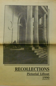
Newspaper - PETER ELLIS COLLECTION: RECOLLECTIONS PICTORIAL LIFTOUT
Historical lift out. Newspaper. Titled RECOLLECTIONS Pictorial Lift out 1990.1 looking down Mitchell St. from Railway Bridge. 2 Original railway station viewed from Mitchell St. bridge. 3 The great extended Hustlers mine. 4 1873 photo recently extended town hall with corn exchange at front left. 5 looking north westerly from city rec reserve at royal hustlers. 6 children play on mullock heap in front of a view of westerly quarter of Sandhurst. 7 Bank of Victoria, Mitchell St. left is Bendigo's original post office. 8 Looking down from what is now Rosalind Park. Shamrock Hotel can be seen on corner of Williamson St. and Pall Mall. This photo predates the construction of post office and law courts. 9 girl eating fairy floss. 10 4 kids on 1 horse in procession. 11 monkey and pedal car, a novelty attraction 1940's. 12 pony rides. 13 flying horses (ride). 14 processions past city hall. 15 Original ANZ bank corner Williamson St. & Pall Mall. 16 Chinese Dragons Bendigo Easter Fair 1940's. 17 City Hall viewed from Bull St. 18 City Hall original ceiling. 19 new town hall 1861. Mike Butcher, local historian. 21 Interior plan of city hall (ground floor) 22 circa 1920's 23 Tattered fragment original architect's drawing. 24 original assembly room. 25 Camp Hill PS Shamrock hotel without top story 27 shop with signage advertising Bushells, Bex and Swallow's Biscuits. 28 View from where fountain is now. 29 Hargreaves St. Looking south, now Hargreaves mall. Horse drawn water tank watering down road. 30 Central Deborah Gold mine poppet head. 31 Borough town hall, tram ways. 32 Original ANZ Bank corner Williamson St. and Pall Mall, demolished in mid 1960's. 33 Bush's store corner Williamson and Myer streets.34 Men on boat, don't know what or where. 35 Shearers. 36 men on a three wheeled bike. 37 4 Gold miners with shovels. 38 6pm closing, no trade Sundays, no women in main bar. 39 Peaceful scene Castlemaine 1940's Photographer Alan Doney. 40 Qantas Jet the City of Bendigo Tullamarine Airport. BCV-8 camera man & Advertiser photographer. 41 Ladies. 42 Tennis -> men and women (women in hats). 43 Sandhurst footy team. 44 Early school photos.bendigo, history, photographic history -
 Ringwood and District Historical Society
Document - Research Notes, Richard Carter, Land Subdivisions in Ringwood 1890-1950
Handwritten table listing main local pre-1950s subdivisions in the Ringwood area, with estate names, streets, number of allotments for sale, and where known, vendor agent, LP (Lodged Plan) title registration number, and auction/sale date, some with sale price.Pg1 RINGWOOD STATION ESTATE LP3070 (Year?) Station Street, William Street (now Kendall Street), Wantirna Road, Station Street Pg1 RINGWOOD TOWNSHIP ESTATE LP5577 (1913) Station Road (now Warrandyte Road), Pratt Street (part now Aird Street), Whitehorse Road Pg2 RINGWOOD ORCHARD ESTATE LP4315 (1914) Brysons Road, Hillcrest Road, Anzac Avenue, Sulva Road Pg3 RINGWOOD RAILWAY ESTATE LP7522 (1918) Whitehorse Road (now Mount Dandenong Road), Dublin Road, Freeman Street, Patterson Street, Bona Street Pg4 THE RINGWOOD ESTATE LP7578 (1919) Warrandyte Road, Hobart Street, Paxton Street, Arnold Street Pg5 GARDEN FARMS ESTATE (LP?) (1919) Canterbury Road, Armstrong Road, Bungalook Road, Orchard Road, Bayswater Road (now Mountain Highway) Pg6 THE RINGWOOD ESTATE (SECOND SUB-DIVISION) LP7604 (1919) Warrandyte Road, Tamar Street, Derwent Street, Mersey Street Pg7 RINGWOOD STATION ESTATE LP7703 (1919) Bedford Road, Williams Grove (now Lena Grove) Pg8 RINGWOOD TOWNSHIP ESTATE LP8198 (1919) Wantirna Road, Ellison Street, Haig Street, Greenwood Avenue Pg9 EASTFIELD ESTATE (LP?) (1920) Eastfield Road, Longview Road, Pleasant Rise, The Mount Pg10 ELECTRIC RAILWAY ESTATE RINGWOOD LP9473 (1922) Campbell Street, Myrtle Avenue, George Street (now Tudor Court), Henry Street (now Myrtle Avenue), Williams Grove (now Lena Grove) Pg11 RINGWOOD PARK ESTATE LP7884 (1922 - two stages) Wonga Road (now Loughnan Road), William Street, Andrew Street, Harrison Street Pg12 HEATHMONT STATION ESTATE LP11009 (Date? - after 1922) Lisgoold Street, Viviani Crescent, Balrour Avenue, Station Street (now part Heathmont Road and part Wainui Street) Pg13 RINGWOOD RAILWAY ESTATE LP10507 (1923) Whitehorse Road, Sherbrooke Avenue, Burwood Avenue, Bonview Avenue, Heatherbrae Avenue, Grant Crescent Pg14 GARDEN HOMES ESTATE (LP?) (1923) Mullum Road, The Centreway, Wattle Crescent (now Wattle Avenue) Reserve Crescent (now Reserve Road) Pg15 DUBLIN ROAD ESTATE LP11993 (1923) Alexandra Road, Vonadawn Avenue, Green Street, Wood Street, Howard Avenue, Bedford Road, Dublin Road Pg16 CARLINGA ESTATE RINGWOOD LP9620 (1923) Bourke Street, Bond Street, Ringwood Street Pg17 PRATT'S JUNCTION ESTATE (LP?) (1923) Junction Street, Georges Road, Oliver Street, Whitehorse Road Pg18 EAST RINGWOOD ESTATE LP10492 (1923) Bona Street, Patterson Street, Miller Grove, Fairview Avenue, Eastfield Road, Whitehorse Road (now Mount Dandenong Road) Pg19 COLEMAN'S HEATHMONT ESTATE LP9974 (1923) Canterbury Road, Bedford Road, Alvena Crescent, Coleman Street, Leonard Street (now Royal Avenue) Pg20 RINGWOOD HEIGHTS ESTATE LP10506 (1924) Whitehorse Road, Bonview Avenue, Grant Crescent, Hillcrest Avenue, Heatherbrae Avenue, Margaret Street, Mary Street Pg21 EAST RINGWOOD STATION ESTATE LP10551 (1924) Knaith Road, Wenwood Street, Lois Street, Victoria Street, Station Street (now Railway Avenue) Pg22 GRAND VIEW ESTATE LP11019 (1924) Whitehorse Road, Rupert Street, Herbert Street, Leonard Street Pg23 RINGWOOD RAILWAY ESTATE & RINGWOOD HEIGHTS ESTATE - FINAL SECTIONS LP10506 & LP10507 (1924) Whitehorse Road, Sherbrooke Avenue, Burwood Avenue, Bonview Avenue, Heatherbrae Avenue, Margaret Street, Mary Street, Grant Crescent Pg24 RINGWOOD EAST ELECTRIC STATION ESTATE (LP?) (1924) Railway Parade (now Patterrson Street), Federal Road, Howship Avenue (part now French Street), Dublin Road, Rosedale Crescent Pg25 BEDFORD PARK (now Ringwood Secondary College) (LP?) (1924) Bedford Road, Adams Street, Anderson Street, Joyce Street, Graham Road Pg26 CROWN JEWEL ESTATE LP11645 (Private sales after 1924) Mount Dandenong Road, Mirabel Avenue, Valda Avenue, Evon Avenue, Velma Grove Pg27 GRAND CENTRAL ESTATE LP10917 (1925) Heathmont Road, Great Ryrie Street, Douglas Street, Garden Street, Bellevue Avenue Pg28 RINGWOOD (unnamed estate - 1926) Nelson Street, Seymour Street, Whitehorse Road Pg29 EAST RINGWOOD RAILWAY STATION ESTATE (YEAR? - 25 shops 60 villas) Railway Avenue, Dublin Road, Lawrence Grove, Stanley Avenue, Knaith Road Pg30 CHARM VIEW ESTATE (LP?) (year? - after 1926) Canterbury Road, Heathmont Road, Dickasons Road, Bennjett Avenue, Orchid Street Pg31 SUNBEAM ESTATE LP12150 (Circa 1925) Govt Road (now Old Lilydale Road), Sunbeam Avenue, Holland Road, Everard Street (now Everard Road) Pg32 FAIRVIEW ESTATE EAST RINGWOOD LP10853 (Circa 1924) Eastfield Road, Patterson Street, Margaret Street (now Short Street) Pg33 EAST RINGWOOD TOWNSHIP ESTATE LP3025 (Circa 1924 - 35 allotments) Mount Dandenong Road, Grey Street, Eastfield Road Pg34 EAST RINGWOOD TOWNSHIP ESTATE LP3025 (Circa 1924 - 49 allotments) and STATE SCHOOL ESTATE (26 allotments) and EAST RINGWOOD STATION ESTATE (14 shop sites) Mount Dandenong Road, Grety Street, Dunn Street, Eastfield Road, King Street, Holland Road, Dublin Road, Patterson Street, Bona Street Pg35 EAST RINGWOOD CENTRAL ESTATE LP17004 (1948) Knaith Road, Shasta Avenue, Talofa Avenue, Russet Road, Dublin Road Pg36 WARE ESTATE LP43360 (1958) Ware Crescent, Davey Drive, Grey Road (now Grey Street), Mount Dandenong Road Pg37 Lot 57 Kendall Street LP3070 (1939) £75.0.0 Pg37 Lot 14 LP7346 (year?) £225 Pg37 Lot 8 WHITE HORSE ESTATE LP14010 (year?) Maroondah Hwy, Seymour Street £98.9.0 Pg37 Lots 4-14 incl. LP10902 (year?) £300 Pg37 Lots 69&70 LP2216 (1939) Bedford Road, Pitt Street £500 Pg37 Lots 60&70 LP2216 (year?) £460 Pg37 MOUNTAIN VIEW ESTATE LP10902 (1936) Lots 1&2, 19-22 Wantirna Road, Daisy Street £50 Pg38 RAILWAY STATION ESTATE RINGWOOD EAST LP7522 (1925) Lots 16 to 19 £250 Pg38 RINGWOOD PARK ESTATE (LP?) (1924) Lot 112 Munro Street £230 Pg38 RINGWOOD TOWNSHIP ESTATE (LP?) (1925) Lot 57 Wantirna Road £850 Pg38 ELECTRIC RAILWAY ESTATE LP9473 (1925) Lot 98 & 99 £180 (30/- foot) Pg38 ELECTRIC RAILWAY ESTATE LP9473 (year?) Lot 100 £233.12.6 incl improvements (£2.12.6 foot) Pg38 Lot 22&23 Bedford Road Heathmont (LP & year?) £675 incl improvements Pg39 Lot 9 Mullum Mullum Road LP8221 (1923) £150 Pg39 Lot 27 Haig Street LP8198 (1925) £825 Pg39 Lot 56 Haig Street cnr Wantirna Road LP8198 (1923) £171 Pg39 Lots 3 & 4 Loughnan Road LP9626 (192?) £147 Pg39 Lots 98 & 99 Myrtle Avenue LP9473 (1925) £180 Pg39 Lots 80 & 81 Myrtle Avenue LP9473 (1929) £150 Pg39 Lot 30 Sherbrooke Avenue LP10507 (1926) £700 incl improvements Pg40 Lot 10 (year?) LP7703 £750 Pg40 Lot 36 (year?) LP7522 £25 Pg40 Lot 38 Pitt Street LP2216 (year?) £350 Pg40 Lot 7 Dublin Road cnr Green Street LP11993 (year?) £300 -
 Bendigo Military Museum
Certificate - LIFE MEMBERSHIP 1947, FRAMED, 8/5/47
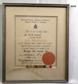
Doctor HAROLD ROBERT CATFORD was the first to be made a Life Member of the Bendigo RSL Sub Branch. The certificate was signed on the 8th Day of May 1947. He was first elected to Committee of the Bendigo Branch in 1918 and retired after 29 years at the AGM 1947 serving the whole time as Vice President. Doctor Harold Robert Catford enlisted as a Captain on 23.6.15 age 41 years and attached to HQ 29th Batt AIF. Embarked for overseas 10.11.15, transfer to 8th Field Ambulance 6.10.16. At various times he was attached to 5th Div Ammunition Column and 2nd A.C.C. Station, promoted to Major 24.8.17. He returned to Australia on 26.9.17 for personal reasons and his appointment in the AIF was terminated on 11.12.17. from 1.1.18 he was RMO to several military units including the 38th Batt in Peace time. Promoted to Lt Col on 19.4.23, placed on the AAMC reserve list 30.1.30 and then the retired list 30.1.1934. Life membership certificate of the Bendigo RSL awarded to Dr HR Catford. Certificate is set in a yellowish cardboard frame inside a silver wooden frame. The certificate is in colour with a red seal and signatures of Federal President and Secretary of the RSSILA. A set of WWI ribbons has been placed in the frame.brsl, smirsl, life membership -
 Stawell Historical Society Inc
Photograph, Indigenous or First Nations People at Carrs Plains 1874 Richardson River Tribe
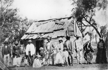
Photo taken at Carrs Plains in 1874 of Indigenous or First Nation People outside a wood and bark hut. In 1861, William Dennis of Carrs Plains Station, a staunch Methodist became Honorary, Aboriginal Protector for the area. One of his main tasks to give Government supplied food and clothing to the Aboriginals. Many district, remaining Aborigines became based at Carrs Plains, and their dead were buried in a cemetery on the station. The cemetery is show on survey map of Wirchilleva Borough, in corner of camping & water reserve near surveyed Bismarck township. In a Protector's report 1869, Dennis wrote that only one male worked regularly on the property, a Bullock driver.Black and white photograph of a wood and bark hut with a group of men, women and children out the front. Richardson River Tribe.Anthony & Lubra, Donald & Affie my ? Herbal? Black Billie Great Rider, Kitty Supulants? Lubra Jonny Callaghan Jr., Four? Supulant? Harry, Blind Tommy & Lubra, 1874 Reproduction rights reserved Copied by State Library of Victoriastawell aboriginal portrait -
 Ringwood RSL Sub-Branch
Medal - Assorted Vietnam medals, Vietnam medals
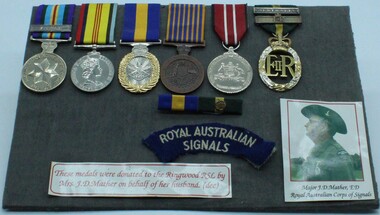
Group of 6 Vietnam era medals complete with shoulder title for RA Sigs.Australian Active Service medal clasp Vietnam. Logistics support medal. Reserve force decoration. National medal. Australian Defence medal and Efficiency decoration with 2 clasps QE11. 3166251 J.D. Mather complete with photograph of Major Mather. -
 Bendigo Historical Society Inc.
Map - FORTUNA HUSTLER'S MINE - PLAN OF FORTUNA HUSTLER'S MINE
Map and plan of the Fortuna Hustler's Mine on the Hustler's Line of Reefs. Bulletin No 33, Plate No 1. Plan gives depth of the different levels. Bendigo Railway Station is on the map and also a number of the streets. Carpenter Street is called Cemetery Road. Also on the Hustler's Line of Reef is the Summer Hill Shaft. Shown is the Hustler's Royal Reserve No 2 Lease. Map has the Geological Survey of Victoria crest. It is signed by H Whit ? an Underground Survey Office Bendigo, September 1913. map, fortuna hustler's mine, hustler's royal reserve no 2 lease, summer hill shaft, hustler's line of reef -
 Ballarat Base Hospital Trained Nurses League
Priscilla Wardle - Trainee Ballarat District Hospital, 27/02/1905 to 01/03/1908 and WW1 Nurse. Also Edith Popplewell & Lily MacKenzie
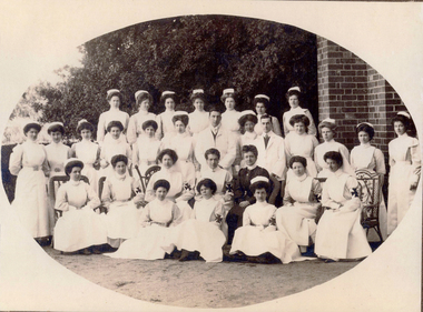
No 1: Matron Eagleton with Nursing Staff, Ballarat & District Hospital. Priscilla Wardle, far right - trainee nurse 1905-1908. No 2: This could be a group of trainee nurses at Ballarat Hospital. Circa 1906/1907. The nurses with the grey looking sleeves in this black and white photograph may be wearing the lilac uniform of Trainee nurses. The sitting nurse on the far right may already be qualified because she appears to be wearing the white of a trained nurse. Sitting in the middle with the cheeky grin could be Priscilla and the standing nurse on the far left could be Edith Popplewell. No 3: This photograph is labelled 1907 and Priscilla would have just commenced her training. She appears to be “fanning” a female patient presumably to cool her down. This could be upstairs in the Queen Victoria’s Women’s Ward. Priscilla graduated as a nurse in 1908. In this photograph Priscilla was at age 23 years. No 5: Sheila Kelly (left) and Priscilla Wardle. This photograph is labelled 1909 and shows Priscilla in an all white uniform indicating she has qualified as a nurse. Sheila Kelly appears to have darker sleeves/blouse (lilac) and may still be a trainee. No 6: There is a very good chance that this photograph is Edith Popplewell, standing left, Lily MacKenzie , standing on the right and Priscilla seated. Writing in her album is very hard to read but it appears to be “Pop McK & I”. The arm bands with the St John Cross denote they are “charge nurses” maybe in charge of a ward. Taking all this into account the photograph could be circa 1909/1910. No 8 & 9: Priscilla painting what appears to be a gate while wearing her nurse uniform. She has a big grin on her face. Together with Lily MacKenzie they were the principals in the Mount Stuart Private Hospital at 18 Duke Street. Daylesford. This property is now known as Mount Stuart House. Priscilla appears to be on Central Spring Road with the Daylesford Post Office in the background. Photograph 9 is labelled 1914 which would make it near the end of their tenancy between 1911 and 1914. No 10: This photograph raises some questions. Priscilla appears to have darker sleeves /blouse (lilac) which may indicate she is still a trainee however Priscilla is also wearing a “charge nurse” arm band. While my research shows trainee nurses can be a “charge nurse” this is not common practise. The scene appears to be at the door of a house/home. I am not sure if the children’s ward/orphanage at the Ballarat Hospital at this time was in such a building. It could be that it is at the Mount Stuart Hospital but this would mean Priscilla and Lily have duplicated the wearing of the “charge nurse” arm band. The St John’s logo looks different too. Priscilla Isabel “Pearl” Wardle (1884-1967). The armband indicates Priscilla is a Charge Nurse at the Ballarat Hospital. Nothing else known. No 11: Mary & I at Mount Stuart – House Daylesford – This is probably the nursery at the Mount Stuart House Private Hospital being run by Priscilla Isabel “Pearl” Wardle (1884 – 1967) and Selina Lily (Lil) MacKenzie or McKenzie (1882 – 1975) between 1910 and 1914. Mary is certainly Mary Young MacKenzie or McKenzie (1865- 1942) Lily’s stepsister who trained at Ballarat Hospital as “Mary Young “at the same time as Priscilla and Lily. Mount Stuart House still stands at 18 Duke Street Daylesford. Photo date 1912. No 12: Priscilla wearing her distinctive Queen Alexandra’s Imperial Military Nursing Service Reserve cape and badge. Possibly while nursing in London for a month in 1919 after the war. No 12A: Priscilla Wardle - WW1 Diary, OCR enabled. No 13: Priscilla and friends at No. 7 General Hospital, Malassises, Saint Omer, France in July 1915 The old monastery being used as a hospital can be seen in the background. The tents are the nurses quarters. This photograph may have been taken at the same time as the group photograph on page 250 of the diary transcription. Priscilla is thought to be the nurse at the centre in the QAIMNSR uniform. The nurses quarters at the No 7 General Hospital in Saint Omer in France where Priscilla worked for most of the first year of her Diary. Their Monastery (Hospital) at Malassises can be seen in the background. No 15: Priscilla is an Acting Sister working at the 2nd General Hospital for Officers in Havre, France, between March and July 1918. The nurses were enjoying their “tea party”. (see also page 253 of the Diary transcription) No 17: Priscilla at Havre - at 2nd General Hospital (Officers Hospital) in Havre., France Friday 29 March 1918 to Monday 29 July 1918 note the two dark bands on her right sleeve denoting that she is an “Acting Sister”. Priscilla is 34 years of age in this picture and in the three weeks prior to this posting she met Cyril Terence Charles Kirby (1892-1968) her future husband at the 42nd Stationary Hospital in Flixecourt while he was serving with the British Army during the battle and evacuation of Amiens. No 18: Priscilla Wardle at No 8 Stationary Hospital Wimereux, France - from Saturday 24 June 1916 to Tuesday 18 September 1917, Priscilla worked at this hospital for 15 months her longest time in one hospital. during the war. While at Wimereux on Sunday 1 July 1917 she was appointed an Acting Sister. Priscilla once said she disliked nursing in her cape and badges and here she is in her favourite “uniform” for work “the robe” as she called it. She may be leaving the “operating theatre” at Wimereux in this photograph. No 19: Priscilla worked in various operating theatres throughout France. This could be after she became an anaesthetist in 1918 and worked with this team. She is wearing her favourite uniform which is more comfortable. She did not like the collars and capes that were required to be worn. No 20: Priscilla and Sister Michael Meeke? (details not found) are having a quiet drink at the 2nd General Hospital for Officers in Havre, France. Note the dark bands on their sleeves denote their rank as nursing “Sisters”. While it looks like they are smoking look more closely they are in fact holding a “flute” style probably “cocktail” glass. Tea parties and cocktails, Havre could almost have been fun. No 22: 1913 – Ballarat nurse Priscilla Isabell “Pearl” Wardle (1884-1967) in Cannes on the French Riviera during leave from between Friday 20 February 1918 and Friday 6 March 1918.Priscilla is second from the left wearing her distinctive QAIMNSR cape of grey with dark “wine” coloured border. The other nurses are wearing their “travelling” army uniform. They were rudely called “Salvation Army Lassies” by American nurses for the way they were dressed. (see page 232 of Priscilla’s War Diary) The description of 1913 on this photograph is confusing. No 23: Priscilla with her best friend Edith Victoria Donaldson somewhere in the “mysterious far east” on their trip on the Orontes. Priscilla is second from left - this may have been taken at Durban during Priscilla's return to Australia in 1919. No 25: Priscilla Wardle, Ballarat nurse in her Queen Alexandra’s Imperial Military Nursing Service Reserve (QAIMNSR) uniform. Notice the distinctive grey cape with “wine coloured” border Priscilla is also wearing her QAIMNSR qualification badge (medal) on the right side. Because she has no dark (wine coloured) bands on her sleeves so this photograph may be before 1 July 1918. No 26: Priscilla met her husband to be English army Lieutenant Cyril Terrence Charles Kirby during the battle and subsequent evacuation of Amiens in France. As an army nursing “Sister” Priscilla also held the rank of Lieutenant. Priscilla was stationed at the 42nd Stationary Hospital between 7/3/18 and 23/3/18. She had just completed a fortnight break at Cannes on the French Riviera. They were married at Priscilla’s home “Waverley" at 215 Dawson Street Ballarat on Saturday 15 November 1919. Nov 15, 1919 – Mr and Mrs Kirby. The bride Priscilla Isabell “Pearl” Kirby (nee Wardle) (1884-1967) and the groom Cyril Terence Charles Kirby (1892– 1968) on their wedding day. Priscilla was 34 years of age and Cyril 27 years of age however their marriage certificate states that they were both 34 years of age. Their marriage certificate states they were married at Waverley, Dawson St, South, Ballarat in a Presbyterian service conducted by the Rev. John Walker, a Minister of the Presbyterian Church of Australia and the Moderator General of the Church we think for Victoria. Was it in an outdoor setting as the surrounds in this photograph seem to indicate. Their witnesses were Robert and Olive, Priscilla’s brother and sister. Cyril signed as C. Terence. C. Kirby and Priscila signed as Priscilla I. Wardle. The certificate lists Cyril (Terence) as a Bachelor, Born at sea on a British ship and his occupation as Sailor. His father interestingly is listed as Charles John Kirby, of independent means and his mother as Emily Newman. Priscilla is listed as a Spinster, born in Ballarat with occupation as a Nurse. Her father is listed as Henry Thomas Wardle, Timber Merchant and her mother as Isabella Allan. They are both resident at 215 Dawson St. Ballarat which was Waverley the Wardle family home. No 28: Reverse in Poppy’s handwriting: “Lovingly yours Poppy, Dec 1908” Taken the year after Poppy qualified at BBH. No 29: Reverse in Poppy’s handwriting: “With much love to you Cilla, Poppy 1915” This picture was taken in the same year as the Marquette sinking incident. Edith Catheina Popplewell RRC (1884-1972) in her New Zealand Army Nursing Service (NZANS) Uniform. Poppy is at age 29 years in this photograph. Poppy was awarded the Royal Red Cross (RRC) medal for her heroism during the sinking of the Marquette transport ship. She lost her best friend NZ nurse Lorna Ratray. No 30: Taken in Cairo. Poppy is in the centre and wearing her New Zealand army badge and cape. The two nurses on either side are Australian nurses probably wearing their unique silver Australian Army sunrise badge and cape. No 31: Reverse in Poppy’s handwriting: “Ward 7 on Xmas day 1917, with my love, Poppy, A Happy New Year to you – had the sweetest letter from Bobbie”. (Bobbie is Priscilla’s brother Robert). It is thought the nurse in the centre of the three on the left is Poppy. It is 1917 two years after the Marquette sinking. Poppy appears to be a “sister” note the two dark bands on her sleeve. The uniform also matches that of Poppy 2. This photograph is in Post Card form very common during WWI. Edith Popplewell RRC is the “Sister” in the middle of the group of three nurses on the left. She is a sister not a general nurse because of the two bands on her left wrist denoting her rank. She was in fact the Charge Nurse ( in charge) of Ward 7 at this time. Note the Christmas decorations. Poppy is at age 33 years of age in this photograph.Bobbie is Priscilla’s brother Robert Norman “Bobbie” Wardle (1895-1979). No 32: Lilly MacKenzie & Poppy – Otaki - Australian nurse Selina Lily (Lil) MacKenzie sometimes McKenzie (1882– 975) grew up and trained as a nurse in Ballarat Victoria. After completing her training Lily and Priscilla Isabell “Pearl” Wardle (1884 – 1967) conducted the Mount Stuart House Private Hospital in Daylesford Victoria. In late 1913 Lily travelled to Otaki, 32 kms north of Wellington in New Zealand and worked at the Otaki Cottage Hospital with close friend Edith Catheina Popplewell “Poppy” (1884-1976) who also grew up and trained as a nurse at the Ballarat Hospital. In 1914 Lily was matron of a private hospital in Taihape 150kms north of Wellington. Both Lily and Poppy volunteered for New Zealand but as New Zealand were not accepting Australian trained nurses she returned to Australia and enlisted in the Australian Army Nursing Service (AANS) in October 1915. Lily went on to serve in Egypt, England, France and Italy where she was awarded the Royal Red Cross (RRC) medal for her service. This photograph is while Lily and Poppy were working at Otaki Cottage Hospital in New Zealand. Circa 1914. trainee, charge sister, ballarat, hospital, 1905, 1908, ww1, mount stuart house, sleeman, wardle, popplewell, mackenzie, military, queen alexandra's imperial military nursing service reserve, daylesford, nurses, private hospital, edith popplewell, france, cairo, diary, ww1 diary, havre, lily mackenzie, eagleton, matron, otaki, new zealand, donaldson, malassises, kelly, young, kirby, priscilla -
Glen Eira Historical Society
Letter - Rosstown Railway
This file contains four items: 1/A black and white photocopy of a letter dated either 07/08/1889 or 09/08/1889, from Robert Lundon to an unidentified recipient discussing an agreement reached between the author – on behalf of the recipient – and Soon Hang Hi in regard, in regards to the allotment known as Webber’s. The agreement is outlined in the letter in what appears to be Chinese characters, and includes the marks of Robert Lundon and Soon Hang Hi. File note from Joy Wu states that the calligraphy is not Mandarin or traditional Chinese. 2/Three sheets of hand-written working notes with information taken from the Victorian Government Gazette on THE ROSSTOWN AND MURRUMBEENA LAND COMPANY LIMITED, THE ROSSTOWN JUNCTION RAILWAY AND PROSPERITY COMPANY LIOMITED, and THE ROSSTOWN JUNCTION, ELSTERNWICK, AND OAKLEIGH RAILWAY COMPANY LIMITED, covering dates between 1887 and 1894. The notes concern meetings and creditors claims relevant to the companies, with reference numbers for the information source. Date and author of the notes are not recorded. 3/A black and white photocopy of the a partial map of the Rosstown Railway and surrounding area, undated. The map includes the names of landholders in the areas of Brighton, Garden Vale and Elsternwick, as well as other railway lines present in the region. 4/A fold-out map and guide of the Rosstown Rail Trail, including a brief general history of Caulfield as well as a more extensive biography of William Murray Ross and the Rosstown Railway. The map marks and describes significant sites along the trail, including photographs of some of these sites, provided by DF Jowett.documents, correspondence, webber’s, lundon robert, chinese characters, ethnic communities, signatures, text, settlements, taxes, fraser john grieves, lovell r.h., price davies, meetings, communication activities, soon hang hi, commercial events and activities, the rosstown and murrumbeena land company limited, victorian government gazette, bulmer richard, parry john, osment henry, shareholders, creditors claims, the rosstown junction railway and property company limited, finch and best, lawyers, the rosstown junction elsternwick and oakleigh railway company limited, cameron w.c., phillips p.d., garden vale, elsternwick, elsternwick railway station, rosstown, rosstown railway, thomas street, bay street, kooyong road, melbourne and brighton railway, hawthorn road, bambra road, caulfield and frankston railway, booran road, grange road, koornang road, murrumbeena road, north road, north road railway station, east brighton railway station, south road, railway routes, railway lines, railways, land transport, murphy j., caulfield, hamilton t.f., dane p., holloway, webb, ailee john, payne t.b., brodie chas, dane john, o’neil h., mccombie john, mcmillane a., smyth c.d., cooper, ebden, landholders, jeffrey j.d., gill j., balcombe a.e., cooper h., mcnab j., white j., sutherland j., greeves a.f.a., newton m.c., chamley f.b., fowler j., inglis p., grant t., stooke j., swanson g., cochrane c., adams e.b., mccombie thas, keyes robert, brighton cemetery, burials grounds and graveyards, war-ein road, were j.b., holland j., mcmahon c., winter t.l.m., dendy henry, mitchell w., jackson s., were j.e., wickham francis dawe, bryant jane, east brighton railway station, railway stations, maps, allotments, land titles, roads and streets, rosstown rail trail, city of glen eira, tourism, trains, tourism information bureaus, tours, pamphlets, elsternwick railway park, oakleigh junction, princes park, ee gunn reserve, packer park, sites, jowett d.f., weickhardt i.g., return to rosstown: railways land sales and sugar beet ventures in caulfield, land sales, walking trails, ross william murray, transport objects, locomotion, walking, cycling, driving, sports, country mansions, people, caulfield john, builders, construction and demolition workers, occupations, careers, professionals, topography, geology, landforms, horticulture, market gardens, primary industry workers, city of caulfield, mood kee, pennington harold, annual general meetings, caulfield town hall, glen eira city council, carnegie, carnegie station, rosstown station, people by circumstance, migrants, sugar beet, sugar beet mill, sugar beet industry, mills, factories, sea beach lines, bent thomas, parliamentary representatives, neville street, miller street, lemann’s swamp reserve, koornang park, cane sugar industry, breweries, rabbit processing plants, health establishments, hospitals, food production establishments, abattoirs, thieves, social problems, vagrants, theft, squatting, financial economics, debt, finance industry, insurance companies, company managers, bentleigh, ross leila, the grange, leila road, wild cherry road, financial trouble, mortgages, gisborne street, archibald street, riddell parade, victoria railways, glen huntly road, clarence street, college street, gladstone parade, parrell street, aileen avenue, seaview street, land subdivisions, dover street, sussex street, landfill, marara road, booran road, woodville avenue, dorothy avenue, ormond park, royal avenue, ormond railway station, oakleigh road, melten avenue, miller street, munro avenue, lord reserve, neerim road, toolambool road, the rosstown hotel, rosanna street, murrumbeena crescent, commercial establishments, the national bank, rosstown road, kangaroo road, poath road, freda street, hughesdale kindergarten, oakleigh council, hughesdale community centre, civic establishments, galbally reserve, plaques, warrigal road, out and about brochures, orion estate