Showing 285663 items matching "streets,roads,melbourne,map,melway"
-
 Greensborough Historical Society
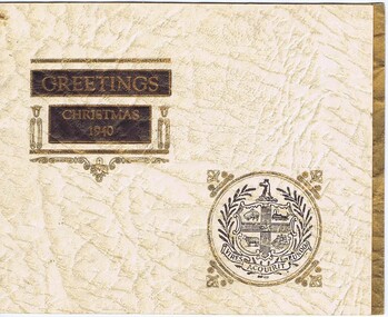
Christmas Card - Digital Image, Melbourne City Council Electricity Supply Department 1940, 1940_
Digital copy of corporate Christmas card sent by Melbourne City Council Electricity Department in 1940.Digital copy of corporate Christmas card.christmas cards -
 Greensborough Historical Society
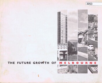
Book, The Future growth of Melbourne, 1967_06
A report to the Minister for Local Government on Melbourne's future growth and its planning administration, June 1967.46 p., text and col. plansmelbourne (victoria), mmbw -
 Women's Art Register
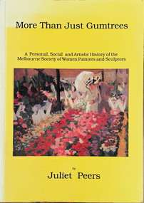
Book, Juliet Peers, More Than Just Gumtrees. A Personal, Social and Artistic History of the Melbourne Society of Women Painters and Sculptors, 1993
History of the Society, founded in 1902, told through the stories of three generations of artists. Includes original research, unpublished primary sources and photographs and over 300 biographies of members.Booknon-fictionHistory of the Society, founded in 1902, told through the stories of three generations of artists. Includes original research, unpublished primary sources and photographs and over 300 biographies of members. china painting, portraiture, self-portraiture, flower painting, sculpture, print making, art and craft -
 Greensborough Historical Society
Map, Heidelberg: Historic River Landscape Assessment. Historical maps. Map E 1901-1934 "A Time of projects and improvements", 1985c
Geographical area of around 35 sq. kilometres marked with physical features such as major roads, railways (new extension to Eltham), rivers and properties, also housing sub-divisions and community facilities such as hospitals, parks and sporting reserves and indications of new small scale industries such as dairying. Bounded by Shire of Diamond Valley to the North, Darebin Creek to the West and Plenty River to the East. Black and white sketch map on white paperheidelberg, heidelberg - maps -
 Kew Historical Society Inc
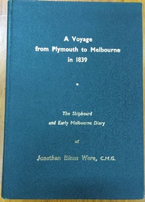
Book, J B Were & Son, A voyage from Plymouth to Melbourne in 1839: The shipboard and early diary of Jonathan Binns Were, 1964
[Melbourne] : J.B. Were & Son, 1964 xv, 309 p. : ill., facsims., maps, port. ; 20 cm. non-fictionwere, jonathan binns, victoria - history -
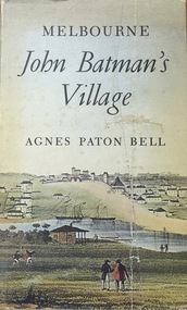 Kew Historical Society Inc
Book, Agnes P Bell, Melbourne: John Batman’s Village, 1965
A history of Melbourne, tracing its development from the riverside village founded by John Batman to the metropolis of the 1960s; includes description of Aboriginal corroborees and other early encounters with the Aboriginal inhabitants of the area.Melbourne, Vic. : Cassell Australia, 1965 xiv, 178p. : ill. (some col.), facsims., map, porto. ; 25cm. non-fictionA history of Melbourne, tracing its development from the riverside village founded by John Batman to the metropolis of the 1960s; includes description of Aboriginal corroborees and other early encounters with the Aboriginal inhabitants of the area.batman, john, 1801-1839, melbourne (vic.) -- history., settlement and contacts - colonisation - 1851- -
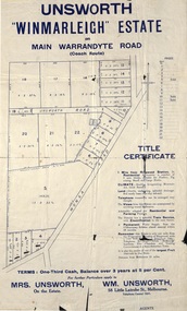 Ringwood and District Historical Society
Flyer, Land Sale Advertisement - Unsworth Winmarleigh Estate, Ringwood, Victoria - circa 1912
Advertisement and attachment for subdivision of land adjoining Warrandyte Road coach route in North Ringwood, with map showing layout of subdivision, summary of local features and services, and terms of sale. Subdivision includes Wonga Road (later Loughnan Road & Warrandyte Road), Unsworth Road, Through Road, Cross Street, and John Street. Contacts - Mrs Unsworth on the Estate or W.M. Unsworth, 58 Little Latrobe Street, Melbourne, Telephone Central 7207. -
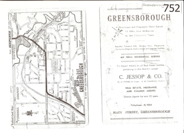 Greensborough Historical Society
Map, Broadbent's, Greensborough, 1953_
This road map was a part of a Broadbent's Melbourne suburban directory from 1953.It shows the lay out of Greensborough's streets in 1953.It also shows some different street names to those used today. It also features a C Jessop & Co. Real estate advertisementA 1 page photocopy of a road map of Greensborough from 1953.Nilgreensborough, c jessop, broadbents, map no 242, road maps, 1953 -
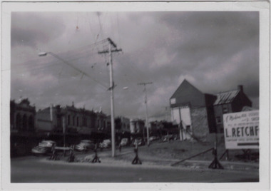 Kew Historical Society Inc
Photograph - Kew Junction during road widening, December 1958
Kew Junction is the intersection of five major roads - Denmark Street, High Street, High Street South, Studley Park Road and Princess Street. The original widening of High Street in the 1930s expanded that street by removing shops on the south side of the street from Cotham Road to Denmark Street. Further widening in 1958 removed shops at the west end of High Street to allow for increased traffic using Princes Street and Denmark Street.Original, black and white positive of Kew Junction, including the corner with Denmark Street during road widening in the 1958.Inscribed verso: "Kew Junction Dec 1958 / When the road was being widened by the removal of a number of shops / Notice saying Retchford's Estate agency's temporary office is at the top end of Denmark Street, Kew"kew junction, denmark street -- kew (vic.), major roadworks -- kew (vic.) -
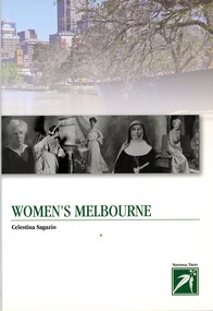 Greensborough Historical Society
Book, Celestina Sagazio, Women's Melbourne by Celestina Sagazio, 2010
This book contains maps and walking tours of Melbourne with a focus on places that are important to the development of women's rights over the years.96 p., paperback, illus. (some col.), maps.melbourne, women, women's rights, walking tours -
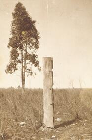 Ringwood and District Historical Society
Photograph, Last post of stockyard, Blood's paddock, corner Wonga and Warrandyte Roads, Ringwood 1910 (4 views)
... Warrandyte Roads, Ringwood 1910 (4 views) ...4 small sepia photographs Written on reverse 2434-1 & -2: "Part of old stockyard, Blood's Paddock, Wonga Road. Arnott's, 1910." 2334-4: "Last post of stockyard in Blood's Paddock, corner Wonga Road and Warrandyte Roads" -
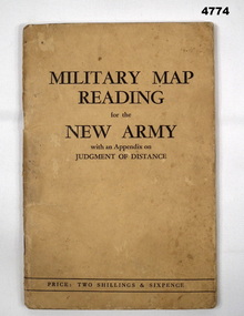 Bendigo Military Museum
Booklet, CAPT W STANLEY LEWIS et al, Military Map Reading for the New Army, 1941
Military Map Reading for the New ArmyCardboard Covered booklet. This has 64 pages with illustrations. It is bound with 2 staples.Military Map Reading for the New Armymap reading, judging distance -
 Port Melbourne Historical & Preservation Society
Document, Chain of title for 351 Princes Street, Port Melbourne 1859-2008, 1913 - 1939
Held by Titles Office from 1859 to about 2004. Peter Parrington obtained them after converting title to more common Torrens.Chain of title for 351 Princes Street, Port Melbourne 1859-2008 Conveyance of current 351 Princes Street 28.06.1866built environment - domestic, families, dennis ryan, bridget ryan, ryan, stephen, clark street, princes street, john harbison, margaret ryan, b & j howletti, j anderson, n clelland, p j (peter) parrington, s l (sue) parrington -
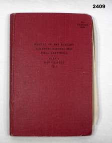 Bendigo Military Museum
Manual - PART 1 MAP READING, Her Majesty's Stationary Office, London, Map Reading, Air Photo Reading and Field Sketching, Part 1 Map Reading 1955, 1955
Item in collection of Dave Waterston, refer Cat No 2410 for service details.Red hard cover manual, 131 pages with some fold out sheets, titled: Map Reading, Air Photo Reading and Field Sketching, Part 1 Map Reading1955“W O Code 8868”books - reference, military history - air force, map reading -
Port Melbourne Historical & Preservation Society
Manual, Collins Street Directory 1961, 1961
This compact Collins Street Directory has 178 detailed maps and shows postal district numbers used at that time.Small directory of Melbourne streets in 1961 including a separate map of all areas covered by the directory & their map reference numbers.built environment - civic, collins book depot {ty ltd -
Whitehorse Historical Society Inc.
Document - Correspondence, Healesville Roads, 14/09/1937
... Healesville Roads ...Claim for reimbursement from Country Roads Board for amounts expended on Main Healesville and Burwood Roads by Shire of Blackburn and Mitchamshire of blackburn and mitcham, victoria country roads board, roads and streets, burwood road, healesville road -
Whitehorse Historical Society Inc.
Document, Roads, 1/05/1932
... Roads ...Return by Shire of Blackburn and Mitcham to Country Roads Board of estimates for maintenance of main roads for financial year, 1932/33.roads and streets, shire of blackburn and mitcham, victoria. country roads board, whitehorse road, blackburn, whitehorse road, mitcham -
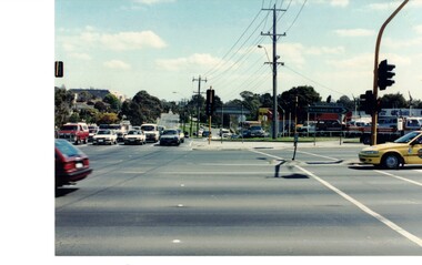 Whitehorse Historical Society Inc.
Photograph - Coloured photograph, Forest Hill Intersection| Canterbury and Springvale Roads
... Forest Hill Intersection| Canterbury and Springvale Roads ...Coloured photograph of the intersection. Springvale Road in the foreground. Canterbury Road heading toward Forest Hill Chase Shopping Centre.canterbury road, springvale road forest hill -
 Flagstaff Hill Maritime Museum and Village
Photograph, The Barquentine "Speculant" at Melbourne Docks, before 1911
This photograph is of the barque "SPECULANT" during one of her voyages to Melbourne. The barquentine SPECULANT was a steel, three-masted sailing ship built in 1895 in Inverkeithing, Scotland, registered in Warrnambool, Victoria and wrecked at Cape Paton, Victoria, 10th February 1911. The SPECULANT had been involved in the timber trade between the United Kingdom and Russia, until sold to its Warrnambool owners and timber merchants Messrs. P.J. McGennan & Co. (Peter John McGennan) in 1902 for 3000 pounds and had her sailed to Warrnambool as her new port. Peter John McGennan was born in 1844 and worked as a builder and cooper in Holyhead, Anglesea, Wales. He immigrated to Australia in 1869 as a free settler and arrived in Warrnambool in 1871 and undertook management of a property in Grassmere for Mr. Palmer. Peter met his wife Emily in South Melbourne and they married in 1873. They had ten children including Harry who lived to 1965, and Andrew who lived until 1958. (The other children were their four brothers - John who was killed in the Dardenalles aged 35, Frederick who died aged 8, Peter who died aged 28, Frank who died aged 5 weeks - and four sisters - Beatrice who died age 89, Edith who died aged 49, Blanche who died aged 89 and Eveline who died aged 48.) In 1874 Peter starting a boating establishment on the Hopkins River. In 1875 he opened up a Coopers business in Kepler Street next to what was Bateman, Smith and Co., moving to Liebig Street, next to the Victoria Hotel, in 1877. In 1882 he then moved to Lava Street (which in later years was the site of Chandlers Hardware Store). He was associated with the establishment of the Butter Factory at Allansford. He started making Butter Boxes to his own design and cheese batts for the Butter Factory. In 1896 established a Box Factory in Davis Street Merrivale, employing 24 people at its peak, (it was burnt down in 1923); and in Pertobe Road from 1912 (now the Army Barracks building). Peter was a Borough Councillor for Albert Ward from 1885 to 1891, he commenced the Foreshore Trust (including the camping grounds along Pertobe Road), and he was an inaugural Director of the Woollen Mill in Harris Street, buying an extensive share-holding in 1908 from the share trader Edward Vidler. They lobbied the Town Hall to have a formal ‘Cutting’ for the waters of the Merri River to be redirected from its natural opening south of Dennington, to its existing opening near Viaduct Road, in order to have the scourings from the wool at the Woollen Mill discharged into the sea. He sold Butter Boxes around the state, and had to ship them to Melbourne by rail. Peter’s purchase of the SPECULANT in 1902 enabled him to back-load white pine from Kaipara, New Zealand to Warrnambool to make his butter boxes then, to gain profitability, buy and ship potatoes and other primary produce bound to Melbourne. (McGennan & Co. had also owned the LA BELLA, which had traded in timber as well, until she was tragically wrecked with the loss of seven lives, after missing the entrance channel to Warrnambool harbour in 1905. It appears that the SPECULANT was bought to replace the LA BELLA.) In 1911 the SPECULANT had been attempting to depart Warrnambool for almost the entire month of January to undergo docking and overhaul in Melbourne. A month of east and south-easterly winds had forced her to remain sheltered in Lady Bay, Warrnambool apart from one morning of northerlies, when an attempt was made to round Cape Otway; she had to return to shelter in Portland after failing to make any headway. With only 140 tons of sand ballast aboard, the ship would not have been easy to handle. Captain Jacobsen and his crew of nine, mainly Swedes, decided to make for Melbourne, leaving Portland Harbour on 5th February 1911. By the 9th they had reached Cape Otway, where they encountered a moonless night, constant heavy rain, and a heavy sea with a south-easterly wind blowing. After safely rounding Cape Otway the course was changed to east, then north-east to take the vessel to a point six miles off Cape Patton, following the orders of Captain Jacobsen, who told the crew to be very careful with the steering, as the wind and sea was running to leeward. The patent log (used to measure speed) had been out of order for the last four months as no-one in Warrnambool was able to fix it: it was intended to have it repaired in Melbourne. In the meantime the crew measured the vessel's speed by looking over the side and estimating wind strength. This compounded the difficulties of imprecise positioning, as the strong cross wind and sea were acting on the lightly laden vessel to steadily drive it towards the shore. At 3.30am on Friday 10 February 1911 Captain Jacobsen and the first mate were looking over the side of the vessel when they heard the sound of breakers and suddenly struck the rocks. The crew immediately knew they had no chance of getting the SPECULANT off, and attempted to rescue themselves by launching the lifeboat, which was instantly smashed to pieces. One of the crew then volunteered to take a line ashore, and the rest of the crew were all able to drag themselves to shore, some suffering hand lacerations from the rocks. Once ashore they began to walk along the coast towards Lorne, believing it was the nearest settlement. Realising their mistake as dawn broke they returned westwards to Cape Patton, and found a farm belonging to Mr C. Ramsden, who took them in and gave them a change of clothes and food. After resting for a day and returning to the wreck to salvage some of their personal possessions, at 10am on Saturday they set out for Apollo Bay, a voyage that took six hours, sometimes wading through flooded creeks up to their necks. The Age described the wreck as "listed to starboard. All the cabin is gutted and the ballast gone. There is a big rock right through the bottom of her, and there is not the slightest hope of getting her off". A Board of Marine inquiry found that Captain Jacobson was guilty of careless navigation by not taking steps to accurately verify the position of the vessel with respect to Cape Otway when the light was visible and by not setting a safe and proper course with respect to the wind and sea. It suspended his certificate for 6 months and ordered him to pay costs. The location of the wreck site was marked for a long time by two anchors on the shoreline, until in 1970 the larger of the two anchors was recovered by the Underwater Explorers' Club and mounted on the foreshore at Apollo Bay. The bell from the wreck was also donated to the Apollo Bay Surf Lifesaving Club but is recorded to have been stolen. Rusting remains of the wreck can still be found on the shoreline on the southern side of, and directly below Cape Patton. Parts of the SPECULANT site have been buried by rubble from construction and maintenance works to the Great Ocean Road, as well as by naturally occurring landslides. Peter J McGennan passed away in 1920. The Gates in the western wall of the Anglican Church in Henna Street/Koroit St are dedicated to him for his time of community work, which is matched with other prominent Warrnambool citizens; Fletcher Jones, John Younger, J.D.E (Tag) Walter, and Edward Vidler. After Peter J McGennan's death Harry, Andrew and Edith continued to operate the family business until July 11th 1923 when the company was wound up. (Andrew lived in Ryot Street Warrnambool, near Lava Street.) Harry McGennan (Peter and Emily’s son) owned the Criterion Hotel in Kepler Street Warrnambool (now demolished). His son Sid and wife Dot lived in 28 Howard Street (corner of Nelson Street) and Sid managed the Criterion until it was decided by the family to sell, and for he remained Manager for the new owners until he retired. Harry commenced the Foreshore Trust in Warrnambool around 1950. The McGennan Carpark in Pertobe Road is named after Harry and there are Memorial-Stone Gates in his memory. (The Gates were once the original entrance to the carpark but are now the exit.). Peter’s great-grandson, also called Andrew, is a Security Officer in Warrnambool. The Patent Log (also called a Taffrail log) from the SPECULANT, mentioned above, and a number of photographs, are now part of the Collection at Flagstaff Hill Maritime Village. The SPECULANT is historically significant as the largest ship to have been registered in Warrnambool, and is believed to have been the largest barquentine to visit Melbourne. It is evidence of the final days of large commercial sailing vessels involved in the Victorian and New Zealand timber trade. The SPECULANT is listed on the Victorian Heritage Register VHR S626Photograph, black and white, titled "The barquentine "Speculant", at Melbourne Docks"Title below photograph reads "The barquentine "Speculant", at Melbourne Docks"flagstaff hill, warrnambool, shipwrecked-coast, flagstaff-hill, flagstaff-hill-maritime-museum, maritime-museum, shipwreck-coast, flagstaff-hill-maritime-village, photograph, speculant, melbourne docks, cumming and ellis, international timber trade, f. j. mcgennan and co. warrnambool, capt. james jacobsen, warrnambool maritime history -
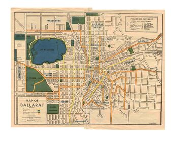 Ballarat Tramway Museum
Map, Greater Ballarat Association and George Netherway, "Map of Ballarat", c1945
Yields information about Greater Ballarat, including trams, buses, locations and streets. Has a strong association with George Netherway.Five colour map of Ballarat, showing streets, places of interest, Parks, tram routes, bus routes, railway lines, prepared by G. C. Netherway, Greater Ballarat Association, for the Victorian Government Tourist Bureau, Ballarat Branch, c1945. Shows suburbs names, location of orphanage, the lack of development north of Howitt St, in Wendouree. Map is part diagrammatic and is not entirely to scale. On rear is a road map of the Ballarat area, lists of statistics, beauty spots, look outs, art and culture, points of historical interest, industrial products and recreation. Note: Image 1, assembled from four scans, does not entirely match at edges. See Reg item 2074 for photographic image of another version map. See Reg Item 5613 for another version of this map. trams, tramways, ballarat, tram routes, bus routes, map, lists -
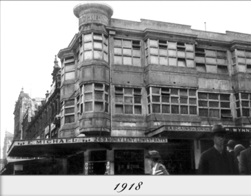 Ithacan Historical Society
Photograph, Michael's Buildings, 1918
... Lonsdale and Elizabeth Streets, Melbourne, Victoria ...The top floor of Michael's Building situated on the corner of Elizabeth and Lonsdale Streets in Melbourne served as the club rooms for the Ithacan Philanthropic Society for forty years from 1918 to 1958, up until when the society built their own club rooms, Ithaca House, at 327 Elizabeth Street. Ithaca House has been the permanent home of the Ithacan Philanthropic Society since 1958.A black and white photograph of a two storey building with a cantilever verandah at street level on a corner in the CBD. The upper two storeys have casement windows around the two sides of the building with a round protruding structure at the corner of the building. -
Port Melbourne Historical & Preservation Society
Document, City of Port Melbourne, Valuation of Licenced Premises in City of Port Melbourne, 1950 - 1974
Valuation of Licenced Premises in City of Port Melbourne. Work papers maintained by the City Valuer, Mr George LEVEY, concerning the valuation of Licenced premises in the City of Port Melbourne.local government - city of port melbourne, george levey, built environment - commercial, business and traders - hotels -
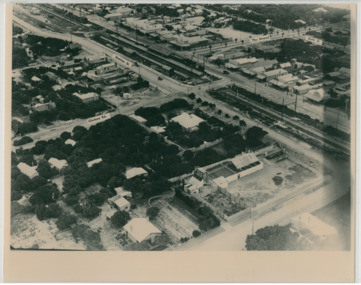 Chelsea & District Historical Society Inc
Photograph - Aerial Photo of Chelsea, c 1923
Points of interest in the photo are Fox Theatre, Chelsea Railway Station and the building site of Masons Theatre on the corner of Chelsea Road and Station Street. Mr William Herbert Hansom was a pioneer of aerial photography in Australia.Black and white aerial photo of Chelsea, bordered by Thames Promenade, Balantyne Avenue, Catherine Avenue and Chelsea Road, Station Street, The Strand, Bath Street.W. H. Hansom ("Manders") Aerial Artist, Personally Conducted Flights over Melbourne and Suburbs St James' Building Bourke Street, Melbournechelsea, aerial photo, station street, chelsea road, the strand, bath street, fox theatre, masons theatre, w. h. hansom, chelsea railway station -
 Melbourne Tram Museum
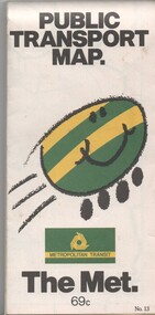
Map, Metropolitan Transit Authority (MTA), "Public Transport Map", c1984
Fold out map (36 sections 9 across x 4 deep), "Public Transport Map", coloured of Melbourne's Tram and Bus routes, route numbers, rail lines, detailed for the central part of Melbourne and the outer Metropolitan services. Includes description of tram and bus routes, private bus routes. On the front cover is The Met's Buzz symbol and their logo. Has contact details for bookings and lost property etc and how to use the map. Priced at 69c, issue No. 13 of c1984. Two copies held.trams, tramways, melbourne, map, tram & bus services, railways, the met, neighbourhood tickets -
 Ballarat Tramway Museum
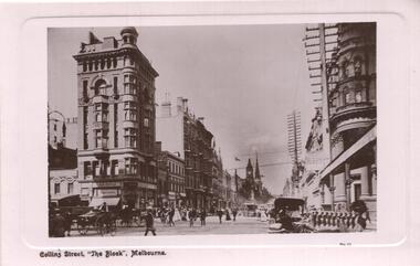
Postcard, GPC Depot Melbourne, Collins St. Melbourne
Glossy postcard with edges raised above the photograph itself of Collins St. Melbourne looking east along Collins St towards the NE corner of the intersection with Elizabeth St. Cable trams in distance with many horse drawn vehicles on both sides of street and pole lines with wires. B.H.Alston building features. Some motor cars in photo. On base of card is title & in bottom RH corner is 'No. 10'. On rear are areas for Address and Correspondence. Title is 'Collins St. 'The Block' Melbourne'. On rear as well is publisher details with Melbourne mis-spelt. Rear of card is finished off white , while front has a light pink finish. Photo printed using photographic paper. Printed in Great Britain. trams, tramways, melbourne, collins st., cable trams -
 Melbourne Tram Museum
Document - Radio Transcript, Melbourne & Metropolitan Tramways Board (MMTB), "Wireless Talk -- Mr. J. D. Barton Staff Officer MMTB - Melbourne Street Transport No. 2", late 1920's
Radio Transcript or script, 7 foolscap typed pages, double spaced titled "Wireless Talk -- Mr. J. D. Barton Staff Officer MMTB - Melbourne Street Transport No. 2". Report looks at the history of horse bus routes in Melbourne, building of the cable trams, the Parliamentary Bills for the cable trams, constructing the lines, Mr. G. Duncan, Mr. Clapp, construction difficulties, the Melbourne Tramway Trust, MTOC, drainage issues, bridges, alterations to the Act, Patent issues with a London company, opening dates and comments about wire rope. Could be a few pages missing given the way it ends, no thank you or formal ending. Item noted dated, presumed late 1920's.Has pencil notation in top left hand corner "6 copies"trams, tramways, public transport, radio stations, horse buses, mto co, melbourne, cable trams, mtt -
Whitehorse Historical Society Inc.
Document - Correspondence, Roads, 01/06/-/10/1933
... Roads ...Correspondence between shires of Blackburn and Mitcham, and Dandenong and City of Chelsea to declare Springvale Road a main road, June- October 1933.springvale road, nunawading, victoria. country roads board, shire of blackburn and mitcham, shire of dandenong, city of chelsea, roads and streets -
 National Vietnam Veterans Museum (NVVM)
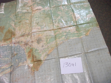
Map, Intelligence Map
Vinyl coated topographical map of part of Vietnam featuring main roads, towns and city locations current or ruined. River locations etc. Names all in Vietnamese language.map, vietnam -
 Greensborough Historical Society
Book - Atlas, Victoria. Department of Sustainability and Environment, Melbourne atlas, 2006_
The purpose of the Melbourne Atlas is to give a spatial view of physical , environmental, social, economic and cultural aspects of Melbourne which can be used in planning. It contains maps and graphs depicting many aspects of life in Melbourne. A snapshot of life in Melbourne in 2006.Various paging, text, illus., colour maps. Wire binding.melbourne, maps, town planning, social conditions -
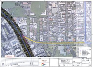 Melbourne Tram Museum
Drawing - Set of 5, Melbourne Metrorail, "Melbourne Metro St Kilda Road - early works", 10/2016
Drawings prepared by the Melbourne Metro project to show the relocation of Domain Interchange, Domain Road and Park St South Yarra to Toorak Road West and St Kilda Road. Drawings prepared for a Heritage Victoria application dated 26/10/2016. Shows the various work stages principally at the site of Domain Junction where the tram tracks had to be relocated to facilitate the construction of Anzac station.Yields information about the relocation of Domain Interchange to facilitate the construction of the Melbourne Metro.Set of five laminated A3 colour prints with a punch hole in the top left hand corner.metro tunnel, domain interchange, domain road, toorak road, st kilda road, heritage victoria, anzac station