Showing 4061 items matching "surveying"
-
 Whitehorse Historical Society Inc.
Document, Division of Survey and Mapping, 1984
Information guide to Parish and Township Plans - Division of Survey and Mapping - Victorian Government..Information guide to Parish and Township Plans - Division of Survey and Mapping - Victorian Government..Information guide to Parish and Township Plans - Division of Survey and Mapping - Victorian Government..crown lands, victorian government, land surveys -
Whitehorse Historical Society Inc.
Article, Needs check on elderly, 1991
A survey to investigate the quality of life of Nunawading's older residents is now under way.A survey to investigate the quality of life of Nunawading's older residents is now under way.A survey to investigate the quality of life of Nunawading's older residents is now under way.aged people, eastern suburbs geriatric centre, city of nunawading, phillips, phillipa, atkinson, bruce, subramanian, chandra -
Whitehorse Historical Society Inc.
Article, Council to survey recycling habits, 1991
An intensive survey of Nunawading residents recycling habits to be conducted by Litter Research Council.An intensive survey of Nunawading residents recycling habits to be conducted by Litter Research Council.An intensive survey of Nunawading residents recycling habits to be conducted by Litter Research Council.city of nunawading, recycling, hawke, graham, litter research council -
 Federation University Historical Collection
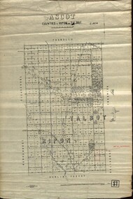
Plan - map, Ascot: Counties of Ripon and Talbot, 18/12/1920
Cadastral map showing parish boundaries and land ownership. "L5270"Maps parishes located in Ascot area. Photo-Lithographed at the Dept. of Lands and Survey.Highlighted parish labelled, Mrs E.C.Sutherland.parish, map, ascot, counties, e. c. sutherland, a. cameron, sweeney, w. j. clarke, mount hollowback, tourello, burrumbeet, glendaruel, dowling forest, a. j. mullett, w. j. butson, 1920, william coghill, chatham, chatham family collection, mrs e.c.sutherland. -
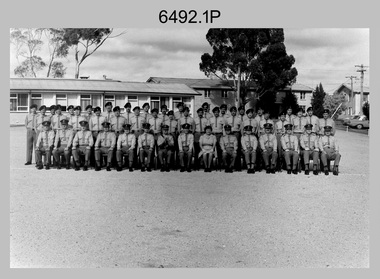 Bendigo Military Museum
Photograph - Army Survey Regiment Group Photos, Fortuna, Bendigo, 1977
This is a set of three black & white photographs of troops from the Army Survey Regiment’s SGT’s Mess and Lithographic Squadron taken in 1977. This is a set of three black & white photographs of troops from the Army Survey Regiment taken in 1977. The photographs are on 35mm negative film and scanned at 96 dpi. They are part of the Army Survey Regiment’s Collection. .1) & .2) - Photo, black & white, 1977. SGT’s Mess Back row L to R: unidentified, George Austen, Dick Manly, unidentified, Syd Davis, Greg Francis- Wright, unidentified (x2), Graeme Jeffers, Bob Scaddan, Alan Hancox, Jeff Lynch, unidentified, Alan Toogood, Mick Dempster. Centre row L to R: John McCracken, Kerry Gallager, Dave Miles, Dick Barwald, Rowan Gillies, Ross Hyde, Ken Slater, Gary Warnest, unidentified, Jim Beard, Jim McDonald, unidentified (x3), Noel Coulthard, Errol Fletcher, Doug Carswell. Front row L to R: Ivor Hastings, unidentified (x2), Alex Cairney, Tony Ellis, Bob Mason, RSM WO1 Aub Harvey, Alan Bunn, Marj Knight, Roger Rix, Manfred Panknin, John McCulloch, Jim ‘Triple J’ Jefferies, Bob Hayden, Tibor Szentirmay. .3) - Photo, black & white, 1977. Lithographic Squadron formed up outside Proofing Hut. Parade commander – WO1 Manfred Panknin. On far-right L to R: Graeme Jeffers, Dave Miles, Jeff Lynch.There are no personnel identified. royal australian survey corps, rasvy, army survey regiment, army svy regt, fortuna, asr, litho sqn -
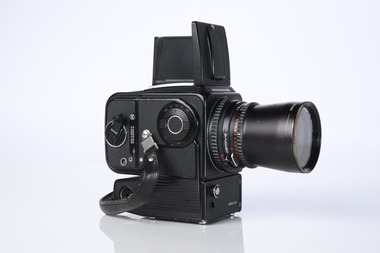 Department of Energy, Environment and Climate Action
Hasselblad aerial camera
... Surveying ...Aerial photos were used to make maps of forest types, timber resources, to survey logging areas and regeneration, to mark boundaries of public land and new plantations, to identify new roads and tracks, as well as for fire suppression. Infrared film was sometimes used to monitor insect and disease attack. The images needed to sharp, with high contrast, and in a large format (most were printed in B&W on 9-inch by 9-inch glossy photographic paper) with at least a 60% overlap to enable stereoscopic viewing and with a 20-30% side lap to allow for aircraft drift. Preferably, the photo scale was close to the final map scale avoid to problems when enlarging and to reduce distortion. Something was needed to supplement the very expensive and infrequent large-area photography programs. From the mid-1960s Victorian foresters began experimenting with small format 70mm and 35mm cameras which proved simple, practical, cheap and flexible. It was found that any SLR camera could be used provided it had a good quality lens and fast shutter speed (preferably down to 1/1000 second). Motorised cameras with a large film capacity had obvious advantages and were essential when access to the camera was not possible during flight. It is also essential for the shutter to operate at low temperatures and those lubricated with silicones were recommended. Components of a typical FCV Divisional Office system included – A Hasselblad or Vinten 70 mm format aerial camera with a focal plane shutter which could be electrically operated. Interchangeable lenses to allow for different photo scales and flying heights. Several large film magazines, which were loaded in a darkroom, each with a capacity of 100 feet or approximately 500 frames. A remote control for the camera in single-shot mode or automatic firing at selected intervals of 2 to 50 seconds. It also needed a frame counter. A light aircraft was modified with an internal mounting for the camera to keep it level and steady. Often a hole was cut through the floor for the lens. The aircraft also needed an inbuilt 12 Volt DC battery to operate the motorised camera shutter. The front passenger seat was generally removed to improve access to the camera. An Aldis drift sight was also fitted. This might be likened to an inverted periscope and is used to determine drift, to facilitate accurate navigation along flight lines and to determine the exposure interval for stereoscopic overlap. This item is kept at Traralgon.Hasselblad 500 ELM camera with 70mm lens, film pack, motor drive and battery In 1964 Hasselblad started production of a motorized camera, the 500 EL The EL/M is a modified version of the EL, "M" means modified, "EL" electric. Perhaps the most famous use of the Hasselblad camera was during the Apollo program missions when man first landed on the Moon. Almost all of the still photographs taken during these missions used modified Hasselblad cameras. forests commission victoria (fcv), forest measurement, surveying, mapping -
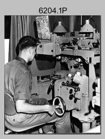
 Bendigo Military Museum
Photograph - Photographic Technicians performing tasks at the Army Headquarters Survey Regiment, c1960s
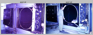
These eight photographs were most likely taken in the 1960s in Lithographic Squadron at the Army Headquarters Survey Regiment, Fortuna, Bendigo. Although Photo .1P is not annotated the remainder have the name of the technicians written on the back. The equipment operated by the technicians is the KLIMCH Commodore camera. The main tasks undertaken by the technicians were most likely enlargements and reductions of map reproduction material. The KLIMSCH Commodore camera was introduced in 1953 and was the largest in the Southern Hemisphere. It was replaced with a new model of the same size in 1979. The new model with its computer-based interface provided productivity gains with improved speed and its consistent results led to less wastage in time and materials. Its variomat lens system provided improved retention of map feature linear weights during the camera reduction process. The typed description pasted on the back of photo .5P states “Cpl R. MacKenzie of Bentley, Perth (WA) of the AHQ Survey Regt, located at “Fortuna”, Bendigo, (Vic). Has been in the Army for 5 years. He removes the lens cap from the 70 inch F16 lens of the giant KLIMSCH camera used in map making for the Army. The camera which was specially made for the Army in Germany is fully automatic and power operated. It is claimed to be one of the biggest automatic cameras of its type in the world. It was made to the specifications of the Aust Army Survey Corps to assist in the production of the very high standard maps for the Army. The AHQ Survey Regt also assists Commonwealth and other Govt departments in the printing of maps required other than for Army needs. The KLIMSCH camera is used for cartographic mapping photography.” This is a set of photographs of technicians operating photographic reproduction equipment at the Army Headquarters Survey Regiment, Bendigo c1960s. The photographs were printed on photographic paper and are part of the Army Survey Regiment’s Collection. The photographs were scanned at 300 dpi. .1) - Photo, black & white, c1960s, Les ‘Snow’ Taylor, Lithographic Squadron .2) - Photo, black & white, c1960s, Les ‘Snow’ Taylor, Lithographic Squadron .3) - Photo, black & white, c1960s, John Rolfe, Lithographic Squadron .4) - Photo, black & white, c1960s, John Rolfe, Lithographic Squadron .5) - Photo, black & white, c1960s, CPL R. MacKenzie, Lithographic Squadron .6) - Photo, black & white, c1960s, unidentified, Lithographic Squadron .7) - Photo, black & white, c1960s, George Graham, Lithographic Squadron .8) - Photo, black & white, c1960s, L to R: Bill Snelson, George Graham, Lithographic Squadron.1P – no annotation .2 to .4 – personnel names (less rank) annotated on back. .5 – name and rank annotated on back, with detailed typed description .6 to .8 – personnel names (less rank) annotated on back. royal australian survey corps, rasvy, army survey regiment, army svy regt, fortuna, asr, litho -
 Bendigo Military Museum
Photograph - Photographic Technicians operating the KLIMSCH Camera at the Army Survey Regiment, Fortuna, Bendigo, c1988
These nine photographs were most likely taken in c1988 in Lithographic Squadron at the Army Survey Regiment, Fortuna, Bendigo. The equipment operated by the technicians is the KLIMCH camera. The main tasks undertaken by the technicians were most likely enlargements and reductions of map reproduction material. The KLIMSCH Commodore camera was introduced in 1953 and was the largest in the Southern Hemisphere. It was replaced with a new model of the same size in 1979. The new model with its computer-based interface provided productivity gains with improved speed and its consistent results led to less wastage in time and materials. Its variomat lens system provided improved retention of map feature linear weights during the camera reduction process. The camera which was specially made for the Army in Germany was fully automatic and power operated. It was claimed to be one of the biggest automatic cameras of its type in the world. It was made to the specifications of the Royal Australian Army Survey Corps to assist in the production of the very high standard maps for the Army. There are several more photos catalogued in the Victorian Collections database of RA Svy personnel operating the KLIMSCH camera.This is a set of four photographs of technicians operating the KLIMSCH Camera at the Army Headquarters Survey Regiment, Bendigo c1988. The photographs are on 35mm colour slides scanned at 96 dpi. They are part of the Army Survey Regiment’s Collection. .1) - Photo, colour, c1988, KLIMSCH Camera. .2) - Photo, colour, c1988, KLIMSCH Camera, unidentified technician. .3) - Photo, colour, c1988, KLIMSCH Camera. .4) - Photo, colour, c1988, KLIMSCH Camera, L to R: SPR Shona Hastie, CPL Paul Baker. .5) - Photo, colour, c1988, KLIMSCH Camera. .6) & .7) - Photo, colour, c1988, KLIMSCH Camera, SPR Shona Hastie. .8) & .9) - Photo, colour, c1988, KLIMSCH Camera, SPR Russell Pajank.35mm colour slides are in good condition.rasvy, royal australian survey corps, army survey regiment, army svy regt, fortuna, asr, litho sqn -
 Bendigo Military Museum
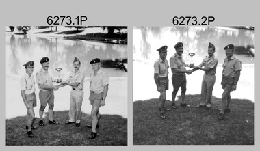
Photograph - Inter-Service Sailing Trophy - Army Survey Regiment, Fortuna, Bendigo, c1980
These eight photographs of Army Survey Regiment personnel with the Inter-Service Sailing Trophy were taken on the bank of Fortuna’s Lake at Bendigo circa 1980. Army Survey Regiment’s personnel were encouraged to participate in Inter-Area, Inter-Service and Combined-Service sporting competitions held annually. The unit’s highly skilled sailors formed the core of Army’s Inter-Service Sailing Team in Victoria for many years.These eight photographs of Army Survey Regiment personnel with the Inter-Service Sailing Trophy were taken at Fortuna, Bendigo c1980. The proof photographs were printed on paper and are part of the Army Survey Regiment’s Collection. The photographic proofs were scanned at 600 dpi. .1) & .2)- Photo, black & white, 1980, Personnel with the Inter-Service Sailing Trophy, L to R: WO2 Noel ‘Nesty’ Coulthard, SGT Doug Carswell, MAJ Sam Schwartz - US Exchange, SGT Rowan Gillies. .3) - Photo, black & white, 1980, Personnel with the Inter-Service Sailing Trophy, L to R: WO2 Noel ‘Nesty’ Coulthard, SGT Doug Carswell, SGT Rowan Gillies. .4) - Photo, black & white, 1980, Personnel with the Inter-Service Sailing Trophy, L to R: SGT Doug Carswell, WO2 Noel ‘Nesty’ Coulthard, SGT Rowan Gillies. .5) - Photo, black & white, 1980, Personnel with the Inter-Service Sailing Trophy, L to R: WO2 Noel ‘Nesty’ Coulthard, SGT Rowan Gillies. .6) - Photo, black & white, 1980, Inter-Service Sailing Trophy, SGT Rowan Gillies. .7) - Photo, black & white, 1980, Inter-Service Sailing Trophy, SGT Doug Carswell. .8) - Photo, black & white, 1980, Inter-Service Sailing Trophy, WO2 Noel ‘Nesty’ Coulthard. .1P to .8P – No personnel are identified.royal australian survey corps, rasvy, army survey regiment, army svy regt, fortuna, asr -
 Bendigo Historical Society Inc.
Document - AULSEBROOK COLLECTION: OPEN DAY PAMPHLET, 1965
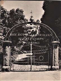
Aulsebrook Collection: Open Day Pamphlet Title: The Royal Ausralian Survey Corps 1915-1965 Date: 1965 Paper Photographs on pamphlets Typed, 12 pages -detailed list of units and individuals related to survey corps -
 Melbourne Tram Museum
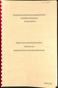
Document - Report, Melbourne & Metropolitan Tramways Board (MMTB), "Preston Origin and Destination Survey February 1975 - Remarks on Survey Cards West Preston Route", Mar. 1975
Report - Foolscap landscape format, red comb binding - approx. 50 pages with notes, titled "Preston Origin and Destination Survey February 1975 - Remarks on Survey Cards West Preston Route". Dated March 1975.In top right hand corner "Lees" in inktrams, tramways, mmtb, tramways, west preston, surveys -
 Bendigo Military Museum
Photograph - Photogrammetric Equipment – Army Survey Regiment, Fortuna, Bendigo, c1960s to c1980s
This is a set of eight photographs of technicians operating photogrammetric equipment in Air Survey Squadron, Army Survey Regiment, Fortuna, Bendigo. c1960s to c1980s. The Wild A9 Stereocomparator and Wild B9 stereo plotter were introduced in 1962. The Wild B8 stereo plotter was introduced in 1966. Technicians used the Wild A9 Stereocomparator to accurately measure between pass, tie, and survey control points on aerial photographs. The Wild B9 and B8s were used for plotting topographic detail and contours. These analogue machines were manually controlled by adjusting the control knobs for the orientation of the 3D image. The B9s used a four and a half square, and the B8s used a nine-inch square photo image on a film or glass diapositive which allowed highly accurate extraction of map features. At first, plotting with B8 and B9 stereo plotters was undertaken at the aerial photography scale of 1:80,000 in pencil onto a controlled plotting sheet. Sheets were then inked up and reduced photographically to the 1: 100,000 publication scale for scribe impression production. In the early days topographic detail and contours were plotted with a pencil or ink pen mounted at the far end of the pantograph arm. The plotting procedure was upgraded to direct plotting in ink with photographic reduction to publication scale. In 1975 four B8s were upgraded with tri-axis locaters as part of the Input Sub-system to enable digital extraction to AUTOMAP 1’s topographic database. When AUTOMAP 2 was introduced in 1982 these B8s were upgraded, and additional machines added to expand the Army Survey Regiment’s digital capture capability. This is a set of eight photographs of technicians operating photogrammetric equipment in Air Survey Squadron, Army Survey Regiment, Fortuna, Bendigo. c1960s to c1980s. Black and white and colour photos are on photographic paper and scanned at 300 dpi. .1) - Photo, black & white, c1965. Unidentified technician operating a Wild A9 Stereocomparator. .2) - Photo, black & white, c1965. Unidentified technician operating a Wild B9 stereo plotter. .3) - Photo, black & white, c1967. L to R: Unidentified technician, SPR Ken Jeffery operating a Wild B9 stereo plotter. .4) - Photo, colour, c1974. Unidentified technician, operating a Wild B8 stereo plotter. .5) - Photo, black & white, c1974. Unidentified technician operating a Wild B8 stereo plotter. .6) to .7) - Photo, black & white, c1979. Unidentified technicians operating a Wild B8 stereo plotter. .8) - Photo, black & white, c1985. Unidentified technician in AUTOMAP 2 operating a Wild B8 stereo plotter..1P, .2P, .4P, .5P, .7P – no annotations. .3P – annotated ‘Standing - , Seated SPR Ken Jefferies (sic). .6P – annotated with date ‘1979’ .8P – annotated ‘AUTOMAP 2’royal australian survey corps, rasvy, army survey regiment, army svy regt, fortuna, asr, air survey, photogrammetry -
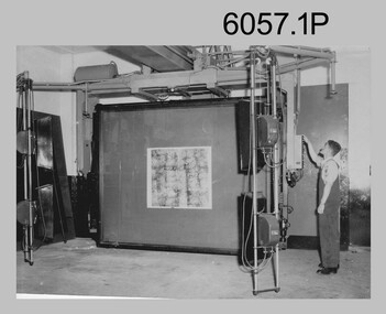
 Bendigo Military Museum
Photograph - Aerotriangulation Production – Army Survey Regiment, Fortuna, Bendigo, c1979
This collection of 19 photos was most likely taken in 1979 in Air Survey Squadron. The PDP 11/70 minicomputer shown photos .2P to .3P was the operating system introduced in 1977 as the mainframe system for the control of the APC4, aerial triangulation block adjustments, SORA OP Analytical Orthophoto control, APR Analytical Terrain Profile Recorder computation, graphics, and general computing. The Zeiss (Jena) Stecometer analytic stereocomparator for air photography shown in photos .5P to .9P was introduced at Air Survey Squadron in 1963. Aerotriangulation production was expedited using computers for analytical photogrammetric processes. The technician accurately measured between pass, tie, and survey control points on aerial photographs. The OMI/Nistri AP/C-3 analytical plotter shown in photos .10P and .11P was introduced in 1972–1973. Photo .11P shows a coordinatorgraph attached to the AP/C-3. The Zeiss D2 Planimat Stereoplotter shown in photo .12P was used for analytical orthophoto control. Wild PUG4 point transfer devices shown in photos .17P to .19P were introduced in c1968 superseding the PUG2 devices. PUG4 devices were used by technicians to stereoscopically view the photography containing the survey control points and the mapping aerial photography. The Control points were transferred from the control photography to the mapping diapositives of aerial photography by drilling their locations into the photographic emulsion.This is a set of 19 photographs of Air Survey Squadron personnel operating aerotriangulation equipment at the Army Survey Regiment at Fortuna, Bendigo, c1979. Black and white photos are on photographic paper and were scanned at 300 dpi. They are part of the Army Survey Regiment’s Collection. .1) - Photo, black & white, c1979, Aerotriangulation tasks, unidentified technicians. .2) to .3) - Photo, black & white, c1979, PDP-11 minicomputers tasks, unidentified technician. .4) - Photo, black & white, c1979, Aerotriangulation tasks, unidentified technician. .5) - Photo, colour, c1979, Zeiss (Jena) Stecometer, unidentified technician. .6) to.9) - Photo, black & white, c1979, Zeiss (Jena) Stecometer, unidentified technician. .10) - Photo, black & white, c1984, OMI/Nistri APC/3-1 analytical stereoplotter, SPR Kristin (Isaac) Skidmore. .11) - Photo, colour, c1979, OMI/Nistri APC/3-1 analytical stereoplotter, unidentified technician. .12) - Photo, colour, c1979, Zeiss D2 Planimat Stereoplotter, unidentified technician. .13) - Photo, black & white, c1979, Aerotriangulation tasks, unidentified technician. .14) - Photo, black & white, c1979, Aerotriangulation tasks, unidentified technician. .15) - Photo, black & white, c1979, Aerotriangulation tasks, CPL Ken Talbot-Smith .16) - Photo, black & white, c1979, Aerotriangulation tasks, SPR David Jobe. .17) - Photo, black & white, c1979, Wild PUG4 point transfer device, WO2 Brian Mead. .18) - Photo, black & white, c1979, Wild PUG4 point transfer device, CPL Andy Wilson. .19) - Photo, black & white, c1979, Wild PUG4 point transfer device, unidentified technician..5P is annotated ‘OMI-Nistri AP/C Analytical Plotter’ and ’Topo 36’. .12P is annotated ‘Zeiss Jena Stecometer Stereocomparator’ and ’Topo 35’. There are no annotations on the other photos.royal australian survey corps, rasvy, army survey regiment, army svy regt, fortuna, asr, aerotrig, air survey -
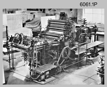 Bendigo Military Museum
Photograph - George Mann Printing Presses operating at the Army Survey Regiment, c1960s
These five photographs of the George Mann printing presses were probably taken circa 1960s in Lithographic Squadron at the Army Survey Regiment, Fortuna, Bendigo. The photos are not annotated except for .4P. The George Mann Fast Five Printing Press was a two-colour demy quad offset press. It was a robust and well-made lithographic printing machine built by the George Mann company in Leeds, UK. The two presses were in service at the Army Svy Regt in the 1960s and 1970s and replaced with the Komori and Planeta offset printing presses in 1975 and 1976 respectively.This is a set of photographs of the George Mann Printing Presses operational at the Army Survey Regiment, Bendigo from c1960s to 1970s. The photographs were printed on photographic paper and are part of the Army Survey Regiment’s Collection. The photographs were scanned at 300 dpi. .1) - Photo, black & white, c1960s, printing press, Lithographic Squadron .2) - Photo, black & white, c1960s, unidentified, printing press, Lithographic Squadron .3) - Photo, black & white, c1960s, printing press, Lithographic Squadron .4) - Photo, black & white, c1960s, SPR Howard Dingle, Lithographic Squadron .5) - Photo, black & white, c1960s, printing presses, Lithographic Squadron.1 to .3 – no annotation .4 - personnel names (with rank) annotated on back. .5 – no annotation royal australian survey corps, rasvy, army survey regiment, army svy regt, fortuna, asr, printing, litho -
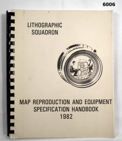 Bendigo Military Museum
Manual - Map Reproduction and Equipment Specification Handbook, 1982
This handbook provided comprehensive technical information principally to the lithographic technician and to other Royal Australian Survey Corps technical trades. Part 1 comprised technical descriptions and photos of lithographic equipment used in military map production. Part 2 provided various tables such as printing sizes conversion tables. Part 3 provided technical guidance on the stipples and screens utilised in the map reproduction process. Part 4 detailed the Pantone Matching System printing colours for map and chart products. Part 5 was a Glossary of Lithographic Technical Terms.Army Survey Regiment Manual/handbook with a manilla cover comprising approximately 100 pages. The pages in the document are in black and white paper providing technical information and photograph identifying lithographic equipment and other information to lithographic technicians. Printed on standard paper bound by a by a black plastic spiral spline.royal australian survey corps, rasvy, fortuna, army svy regt, asr, army survey regiment -
 Bendigo Military Museum
Photograph - Flag Day - Army Survey Regiment Versus School of Military Survey, 10.10.1986
These photographs were taken at Flag Day, an annual sports competition between the Army Survey Regiment and the School of Military Survey, at Bendigo on the 10th of October 1986. The two RASvy units took turns each year to host the event. The day competition usually comprised basketball, cross country, golf, sailing, squash softball, tennis, touch football, tug-of-war and volleyball. The evening competition often included darts, carpet bowls, hookey, quoits and snooker. The scoreboard in the background in photo .11P indicated an emphatic victory for the Army Survey Regiment.This is a set of 13 photographs of Flag Day, Army Survey Regiment versus the School of Military Survey, at Bendigo on the 10th of October 1986. There are more photographs available on 35mm negatives and 35mm positive proofs. The photographs were printed on photographic paper and are part of the Army Survey Regiment’s Collection. The photographs were scanned at 300 dpi. .1) - Photo, black & white, 1986, Ian ‘Rock’ Thistleton. .2) - Photo, black & white, 1986, L to R: CPL Dave Cook, unidentified (x4), CPL Peter Johnson, unidentified. .3) - Photo, black & white, 1986, L to R: CPL John Smith, Peter Tuddenham, John ‘Stormy Tempest, unidentified, Pat Drury, Mick ‘Buddha’ Ellis, Trevor Roddam, Paul Richards, Warren ‘Waldo’ Shirley. .4) - Photo, black & white, 1986, L to R: unidentified (x2). .5) - Photo, black & white, 1986, Eddy Jacobs - No. 13, Paul Baker – with ball, Brian Fauth – 2nd from right, Daryl South - No. 7. .6) - Photo, black & white, 1986, Rick van Der Bom. .7) - Photo, black & white, 1986, L to R: Leah (Hoffman) Peppler, unidentified, Stu Thaxter. .8) - Photo, black & white, 1986, L to R: SGT Mick Gillham, unidentified (x3), Phil Meagher, Barry Hogan, Jim Walker, Daryl South, WO1 Trevor Osborne, CPL Michelle Griffiths, CPL Sherri (Dally) Burke, SPR Avril (Bray) Lloyd. .9) - Photo, black & white, 1986, L to R foreground: SPR Jan (Crighton) Minchin, CPL Eddy Jacobs .10) - Photo, black & white, 1986, L to R: John ‘Stormy’ Tempest, Mark Donnelly, Paul ‘Hutch’ Hunter, Andy Lucas, foreground unidentified, Lyall Camp, CPL John Martin, SSGT Bob Scaddan. .11) - Photo, black & white, 1986, L to R: CO SMS LTCOL Jim Corless, CO ASR LTCOL Don Swiney MBE, RSM WO1 Jeff Lynch, SGT Wayne Rothwell. .12) - Photo, black & white, 1986, L to R: LTCOL Clem Sargent, RSM WO1 Jeff Lynch, CO ASR LTCOL Don Swiney MBE, SGT Wayne Rothwell. .13) - Photo, black & white, 1986, L to R: LTCOL Clem Sargent, RSM WO1 Jeff Lynch, SGT Wayne Rothwell, CO ASR LTCOL Don Swiney MBE.1P – annotated with ‘10 Oct 86 I. Thistleton’ .2P to .13P –No personnel are identifiedroyal australian survey corps, rasvy, army survey regiment, army svy regt, fortuna, asr -
 Federation University Historical Collection
Booklet - Booklet - Prospectus, Bairnsdale District School of Mines, Prospectus, 1904, 1904
Higher education in east Gippsland dates back to 1890, and the opening of the Bairnsdale District School of Mines, In 1986 the Bairnsdale School of Mines and the Sale and Bairnsdale Technical schools amalgamated to form the East Gippsland Community College of TAFE. In 1995 it became the East Gippsland Institute of Technology, and in 2011 changed its name to Advance TAFE. The Bairnsdale District School of Mines Prospectus includes the members of council, a photographic image of the school, teaching staff, rules relating to students and instructors, Constitution, and a prospectus of subjects including Mining and Science Subjects, Diploma Courses, Preliminary Training, Metallurgy Course, Mining Engineering Course, Battery Manager's Certificate, Assayer's Certificate. It also includes a scale of fees, information on the Metallurgical Plant, Chemistry, Assaying and Metallurgy, Geology, Mining Geology, Mining, Petrology, Dynamics and Heat, Magnetism & Electricity, Mechanics Applied to Mining, Land Surveying, Mine Surveying, Algebra, Euclid, Trigonometry, Mechanical Drawing, Practical Plane Geometry, Practical Solid Geometry, Engineering Drawing, Art Subjects, and a list of certificates issued by the school since 1892.Grey soft covered book of 68 pages. The Bairsndale District School of Mines Prospectus includes the members of council, an photographic image of the school, teaching staff, rules relating to students and instructors, Constitution, and a prospectus of subjects including Mining and Science Subjects, Diploma Courses, Preliminary Training, Metallurgy Course, Mining Engineering Course, Battery Manager's Certificate, Assayer's Certificate. It also includes a scale of fees, information on the Metallurgical Plant and its chares, Chemistry, Assaying and Metallurgy, Geology, Mining Geology, Mining, Petrology, Dynamics and Heat, Magnetism & Electricity, Mechanics Applied to Mining, Land Surveying, Mine Surveying, Algebra, Euclid, Trigonometry, Mechanical Drawing, Practical Plane Geometry, Practical Solid Geometry, Engineering Drawing, Art Subjects, and a list of certificates issued by the school since 1892.bairnsdale district school of mines, bairnsdale, school of mines, donald clark, francis w. sewell, j.v.r. anderson, a.d. pleydell, walter seehusen, director, mining engineering, metallurgy, academy of arts, municipal surveyor, 1914 -
4th/19th Prince of Wales's Light Horse Regiment Unit History Room
Booklet, Administration in the field, (Non-Divisional) 1966, 1966
A soft covered booklet giving a general survey of the administration system in the field behind the division.DSN 7610-66-024-4121army administration -
Port Melbourne Historical & Preservation Society
Map - Port Melbourne, Department of Lands and Survey, 20 Sep 1932
Dept. of Lands and Survey Map Sheet 5 Port Melbourne, Parish of South Melbourne.Annotated re MHT precincts on foreshore:Plan sketches re boat harbourtown planning, sandridge lagoon, melbourne harbor trust - port of melbourne authority, transport - railways -
 Bendigo Historical Society Inc.
Slide - AHQ,SURVEY REGT, FORTUNA,BENDIGO, April 1970
Slide. AHQ, Survey Regt, Fortuna, Bendigo. Fortuna lake in foreground with a building at rear.slide, bendigo, ahq, survey regt, fortuna, bendigo., ahq, survey regt, fortuna, bendigo. -
Tatura Irrigation & Wartime Camps Museum
Booklet, Solving the Mystery, 1978
Story of Catholic Church in Tatura. Education and early history of Tatura 1870's. First Catholic Church was built at Baldwinville/Byrneside 1878. Present Church built in 1912.Gold cover, green writing. Survey map on back, Certificate of Title details on front.solving the mystery, burton-clay fr r, catholicism in tatura, tatura, sacred heart church, books, history, local, religion -
Whitehorse Historical Society Inc.
Document, List of significant sites in Nunawading, c1994
Non annotated list - probably prepared in preparation for the City of Nunawading Heritage Survey Project.Non annotated list - probably prepared in preparation for the City of Nunawading Heritage Survey Project.Non annotated list - probably prepared in preparation for the City of Nunawading Heritage Survey Project.city of nunawading heritage survey, arrowsmith, valda -
Whitehorse Historical Society Inc.
Document, Division of Survey and Mapping, 1984
A brief guide to Crown Lands And Survey records commonly used for family history research.A brief guide to Crown Lands And Survey records commonly used for family history research.A brief guide to Crown Lands And Survey records commonly used for family history research.crown lands, victorian government, land surveys -
 Whitehorse Historical Society Inc.
Article, Memorial To Honour Work of Early Victorian Border Surveyors
Memorial to honour Surveyors Black and AllanMemorial to honour Surveyors Black and Allan who surveyed the straight line of NSW and VictoriaMemorial to honour Surveyors Black and Allanblack, alexander, allan, rmit -
Canterbury History Group
Photograph - Elgar's Special Survey, unknown
A photograph of part of Elgar's Special Survey showing owners of property for mostly Canterbury in 1850elgar's special survey, canterbury, canterbury road, riversdale road, burke road, prospect hill road, wattle valley road -
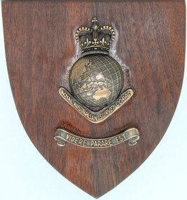 Ringwood RSL Sub-Branch
Souvenir - Wooden Plaque, Royal Australian Survey Corps
Wood plaque with brass fittings. Royal Australian Army Survey Corp post 1954 -
Bendigo Historical Society Inc.
Map - STRUGNELL COLLECTION: BENDIGO GOLD FIELD GEOLOGICAL SURVEY, 1936
BHS CollectionBendigo Goldfieds Geological Survey. Prepared in the Bendigo Office Bottom Section of original map.Dept of Mines Victoriabendigo, gold mining, geological map -
Bendigo Historical Society Inc.
Map - STRUGNELL COLLECTION: BENDIGO GOLD FIELD GEOLOGICAL SURVEY, 1936
BHS CollectionBendigo Goldfieds Geological Survey. Prepared in the Bendigo Office Top Section of original map.Dept of Mines Victoriabendigo, gold mining, geological map -
Bendigo Historical Society Inc.
Map - SANDHURST GOLDFIELDS MAP, 1873
BHS CollectionTopographical map of the Sandhurst Goldfilelds. Surveyed by R Brough. May 1873 Coloured map.bendigo, gold mining, sandhurst goldfields -
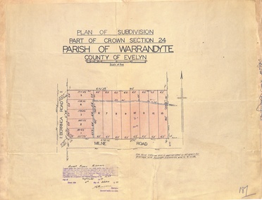 Ringwood and District Historical Society
Map - Plan of Subdivision, Part of Crown Section 24, Parish of Warrandyte, County of Evelyn - 1951
Survey map of residential allotments in Berringa Road and Milne Road, Park Orchards, Victoria. Russell Francis Kinnane, Licensed Surveyor, 4th October, 1951.