Showing 11430 items
matching maps
-
 National Vietnam Veterans Museum (NVVM)
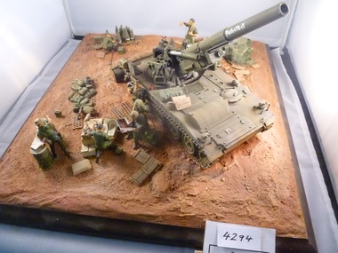
Model - Diorama, M-107 Self propelled artillery
Self propelled gun with blade to dig its own bund. Crew of seven. At rest, one soldier is with a map, one soldier is looking at a magazine, while another soldier is unpacking ammunition.Word PACHELBEL? appears on the gun barrelpachelbel, m-107, self propelled artillery, diorama -
 Port Melbourne Historical & Preservation Society
Photograph - Aerial view of Port Melbourne, overlaid, Charter Keck, Cramer, Nov 2006
Black and White aerial photo with red map overlay, labelled "Port Melbourne 1946 overlaid" in gold/brown metal frame . Shows Yarra River, Coode Canal and Hobson's Bay.built environment - industrial, engineering - canals and drainage, coode island, yarra river, melbourne harbor trust - port of melbourne authority -
Bendigo Historical Society Inc.
Book - TO BIG HILL AND BACK
To Big Hill and Back 1971. Compiled for the back to celebrations and contains historical information on the area with memories of older residents, 49 pages with black and white photographs, advertisements and a map. Includes indexAlma F Mulqueenbendigo, history, big hill, bendigo, history, big hill, ravenswood -
NMIT (Northern Melbourne Institute of TAFE)
Report: Campuses, buildings and rooms - Layouts and listings July 1994 NMCOT
Spiral bound report of 284 pages, A4 size. Consists mainly of campus location maps and room layout plans by building. Prepared by Neville Lester for Northern Metropolitan College of TAFE.northern metropolitan college of tafe, buildings, reports, nmit -
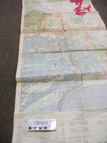 National Vietnam Veterans Museum (NVVM)
Map, XA BINH BA (SE), 1967
Paper in map in strip form of Vietnam highlighting in red specific area of interest luscombe Field Nui Dat Overprint Information from RA SVY and Intelligence Sources Nov 67map, vietnam, ra svy -
 National Vietnam Veterans Museum (NVVM)
Poster - Poster, Information Board, Australian Army Training Team Vietnam - The Team
Yellow metal with white, black & red letterings & numbers. Some of the locations where AATTV members served. Also a map of Vietnam showing Admin Divisions & military regions, June 1967.aattv, vietnam map -
Tatura Irrigation & Wartime Camps Museum
Pamphlet, Get Hooked on Tatura
Pamphlets to rpomote Tatura as a great place to visit with golf and bowls, tennis, horse racing and Waranga basin nearby2 pamphlets. Black and white sketches of cars in traffic jam promoting Tatura to visit and relax, on front, Tatura and relax - in red on back. Map of Tatura and list of industries and tourist sitesget hooked on tatura, promoting tatura, tatura, tourism, documents, pamphlets -
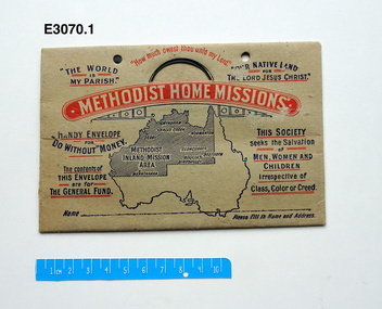 Uniting Church Archives - Synod of Victoria
Offering envelope, Methodist Home Missions
The Methodist Home Missions was the department running the work of smaller churches and charitable institutions such as babies' homes, the Epworth Hospital, chaplaincies to hospitals and prisons, aged care homes, alcohol rehabilitation, local missions to depressed areas and the like. A minister was appointed each year by Conference, on deputation, to travel around Victoria to explain and encourage local congregations to support the work of the missions.Methodist Home Missions cardboard envelope with a blue map of Australia and blue and red text. The is a curved slot at the top of the envelope for inserting coins and squares on the back to mark off weekly giving. methodist home missions, methodist inland mission -
Whitehorse Historical Society Inc.
Map, Applied for the Roman Catholic Church, 1848
Photocopy of manuscript map inscribed 'Reserve 40 Parish of Nunawading'.Photocopy of manuscript map inscribed 'Reserve 40 Parish of Nunawading'. Streets not named. Note on verso: Site reserved for Roman Catholic Church in Nunawading c1848 (Cr Riversdale and Warrigal Roads)Photocopy of manuscript map inscribed 'Reserve 40 Parish of Nunawading'. churches, catholic church, riversdale road, surrey hills, warrigal road, surrey hills -
Whitehorse Historical Society Inc.
Map, Mitcham, 1880s?
Hand drawn map of area north and south of Whitehorse Road and South of Canterbury Road c.1880-1900.Hand drawn map of area north and south of Whitehorse Road and South of Canterbury Road c.1880-1900. Probably sketched by a McClare descendant. Includes locations and names of settlers of that time.Hand drawn map of area north and south of Whitehorse Road and South of Canterbury Road c.1880-1900. whitehorse road, mitcham, mitcham road, mitcham, l l vale road, vermont, canterbury road, mitcham -
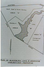 Whitehorse Historical Society Inc.
Photograph, Plan of Blackburn Lake
Black and white photograph of a map of Blackburn Lake showing Adult Deaf & Dumb Society's land and the Camberwell Grammar land on either. Camberwell Grammar was later bought by the former City Of Nunawading.adult deaf & dumb society's flower farm, blackburn lake, camberwell grammar school. -
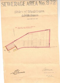 Whitehorse Historical Society Inc.
Document, Sewerage area, 13/07/1933 12:00:00 AM
Plan of sewerage area no. 972, Shire of Blackburn and Mitcham, scale 400' to an inch. 13 July 1933. Note that the area including Stuart Street on the map is now the Thiele Court area.sewerage and sanitation, shire of blackburn and mitcham, whitehorse road, blackburn, railway road, vine street, lithgow avenue, downing street, frankston street, stuart street, thiele court -
 Brimbank City Council
Manilla Folder
Manilla folder with a number of various sizes envelopes containing black and white phots form around mid 20th century of councillors, residents, street. Aslo number of urban plans and maps. -
Moorabbin Air Museum
Equipment (Item) - J B Ryan Collection Navigator's Equipment and Survival Kit see Description for details
-
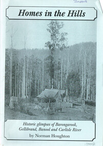 Otway Districts Historical Society
Book, Norman Houghton, Homes in the Hill; Norman Houghton, 2006
Homes in the Hills. Historic glimpses of Barongarook, Gellibrand, Banool and Carlisle River. Norman Houghton. Soft cover. iv, 48 p.; illus, map, diagram. Artwork and layout: Desktop Dymanics. otway ranges; norman houghton; barongarook; gellibrand; banool; carlisle river; agriculture; mining; sport; homes; hills; -
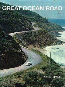 Otway Districts Historical Society
Book, Rigby Limited, Great Ocean Road. K.G. Stepnell, 1972
The Great Ocean Road may be the only road in the world which was built as a war memorial. In 1916, much of Australia was poorly served by roads, and it was suggested that returning servicemen could be given worthwhile employment by building roads in isolated areas. The plan was taken up for the Great Ocean Road, and work was dedicated to the memory of men who had fallen in World War 1. The road itself is a great feat of engineering. It wind around some of Australia's most rugged coastline. Now it is one of the world's most scenic routes, crossing gorges, along precipitous cliffs, through dense forests, and over steeply rolling coastline country.Great Ocean Road. K.G. Stepnell. 1st ed. Rigby Limited; Adelaide (S.A.); 1972. 36 p.; illus., maps. Hard cover. ISBN 0 85179 371 1great ocean road; roads; fishing; timber; twelve apostles; -
 Otway Districts Historical Society
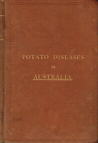
Book, Government Printer, Potato diseases in Australia, 1911
Potatoes are known for their great liability to disease, suffering more from the ravages of fungi than any other crop, and this is largely owing to the fact that they are propagated from tubers which are just swollen portions of underground branches of the stem. Portions of the parent plant in the form of tubers or cuttings are planted year after year, so that any inherent weakness in the original is transmitted to the offspring, and therefore, without a process of selection, deterioration is sure to occur sooner or later. When the tubers are raised from seed and a good selection made from them, they are less liable to disease at least for a number of years. Handbook of fungus diseases of the potato in Australia and their treatment. D. McAlpine. 1st ed. Department of Agriculture, Victoria; Melbourne (Vic); 1911. x, 314 p.; illus., map. Hard cover.potatoes; disease; fungus; agriculture; -
 Ballarat Tramway Museum
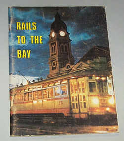
Book, R.T. Wheaton et al, "Rails to the Bay", 1971
84 page book on the Adelaide to Glenelg tram (interurban in style) line with colour covers, maps, black and white photographs, including railway era. Published for the 40th anniversary of opening, in 1971.On top of p3, - 3.00 k8 in pencil.trams, tramways, adelaide, glenelg, interurban, tramways -
 Ballarat Tramway Museum
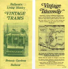
Pamphlet, Ballarat Tramway Preservation Society (BTPS), "Ballarat' Living History- Vintage Trams", Sep. 1984
Yields information about how the BTPS promoted the tramway, with the Design by the printer and the BTPS.Double side paper advertising BTPS with photo of tram 26 (front on prior to reconstruction) printed in green ink on one side, and map and details printed in black ink on reverse side.trams, tramways, btps, ballarat vintage tramway, botanical gardens -
 Beechworth Honey Archive
"Wooden" Diary by Frank Lebbell Frost
This is the diary of Frank L. Frost; a beekeeper who worked in North-East Victoria. It covers from 1915 to 1924.This diary is very significant as it gives details about the methods used by early beekeepers in Australia. As it also contains information such as location and condition of flowering plants preferred by bees in specific locations, this diary is very significant because it can be used to see how those locations have changed over the years.Hand-written diary containing notes, maps, drawings, charts, tables, some newspaper cuttings and financial information. It contains approximately 72 pages. The original diary was encased in wooden frames.hand written, hand-written, diary, beekeeper, record, frost, beechworth honey -
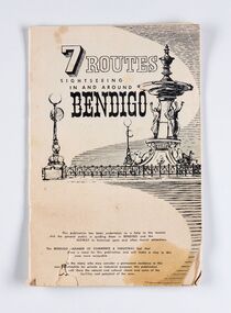 City of Greater Bendigo - Civic Collection
Booklet, J. W. H Publications, 7 Routes. Sightseeing in and around Bendigo, c 1950
A publication promoting visitation and automobile touring around Bendigo and surrounding districts. Suggests seven routes and contains extensive advertising for accommodation, businesses and services within Bendigo and Castlemaine.Thirty two page tourist fold out booklet containing maps and directions for half day and day routes in the district. Booklet also contains advertising promoting Bendigo and District businesses. city of greater bendigo commerce, city of greater bendigo tourism, making a nation exhibition -
Tarnagulla History Archive
History of Tarnagulla Goldmines, 1990s
Folder containing multiple typed and handwritten notes and maps relating to the history of gold mines in Tarnagulla. Compiled by Donald Clark. Includes a series of mine assessment reports by David Bannear (1991). -
 Wodonga & District Historical Society Inc
Photograph - Mitta Junction Township
Mitta Junction which was established about 1920 on the Victorian side of the Hume Dam construction site (originally called the Mitta Junction Reservoir). The town was built to house workers and their families. It included houses, private and government boarding houses, a shop, hall and school as well as tennis courts and a cricket pitch. Mitta Junction was a thriving community with many activities, including Balls and Euchre Nights, held at the Hall which opened in February 1922. The community also fielded a very successful football team in the local competition. After the completion of the Dam, the village and all its contents were sold at auction in June 1936 for £7,000. Individual houses sold at about £40 for removal to nearby towns. The Mitta Junction School which opened in 1922 continued to operate with very small numbers after the village was moved. Its numbers were boosted in the early 1980s by the children of Army staff at the nearby Latchford Barracks Army Apprenticeship School. It finally closed in December 1985.These images are significant because they capture the history of an important vanished town whose residents played a vital role in the construction of the Hume Dam.A collection of black and white images and a sketch map featuring the village of Mitta Junction, built to house workers on the construction of the Hume Dam. Some of the photographs have been mounted on heavy card.mitta junction township, hume dam construction, hume dam history -
 City of Kingston
Pamphlet - Black and white, Robert McCamish & John Gilpin (Vendors), For Private Sale Station Entrance Estate, Highett, 1930s
Sales plan for land in the suburb of Highett, bounded by Wickham Road, Railway Parade, Highett Road and Point Nepean Street. The developing urban area of Highett within the City of Kingston. This land sale pamphlet illustrates the subdivision of land within the municipality and the changing demographic of the district as new houses are constructed. The extension of the railway line from the city to Mordialloc opened up the land for development.Black and white pamphlet advertising for private sale the Station Entrance Estate, Highett. Incorporates a map of the estate bordered by Wickham Road, Railway Parade, Highett Road and Point Nepean Road. Handwritten in black ink on reverse: Station Entrance / Estate / Late [indecipherable]highett, land sales, estate -
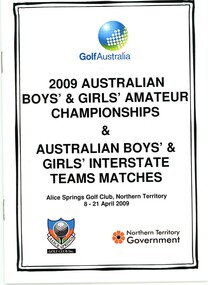 Heidelberg Golf Club
Booklet - Booklet and Memorabilia Collection, Golf Australia, 2009 Australian Boys’ & Girls’ Amateur Championships, and Australian Boys’ & Girls’ Interstate teams matches. Alice Springs Golf Club, N.T. 8-21 April 2009, 2009
Official guide to the 2009 Australian Boys’ & Girls’ Amateur Championships, and Australian Boys’ & Girls’ Interstate teams matches. Played at Alice Springs Golf Club, N.T. 8-21 April 2009. Victorian boys' team Manager Bruce Harding, assistant manager Mark Bamford, Coach David Capaldo. The Team: Geoff Drakeford, Nathan Holman, Anthony Houston, William Hume, Sean Ong, Travis Sharpe. This team finished third in Championships at Alice Springs Golf Club. Accompanied by a memo for team managers, conditions of play, a course guide for Alice Springs GC, 2 blank Alice Springs GC score cards, draw sheets, results sheets, reports by Bruce Harding, a media release. Grace Lennon (HGC) played for Victoria in the Girls’ Team event. Former HGC President Bruce Harding was involved with Victoria's Junior teams from 2000-2010.Booklet 28 p., black text, illus. (some col.). Includes photographs of players. 2 copies. Score cards tri fold, colour. Course guide: 19p., colour maps.bruce harding, australian junior amateur championships, junior golf -
University of Melbourne, Burnley Campus Archives
Map, City of Kew, Hyde Park, c. 1970
(1) Photocopy of hand drawn plan of park showing contours. No 7/3. Scale 1 inch:40 ft. (2) Map 45 from Melway with Hyde Park highlighted.kew, hyde park -
Port Melbourne Historical & Preservation Society
Map - MMBW, c. 1894
Melbourne and Metropolitan Board of Works 1894, Plan number 18 Segments Shown: Between 322 - 486 Smaller scale map incorporating piers, lagoon and town north to beyond boundaryIn pencil: "7/7/94" (Which is the copyright date)engineering - board of works, piers and wharves - railway pier, piers and wharves - town pier, sandridge lagoon, transport - tramways, transport - railways, gasworks, built environment -
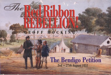 Bendigo Historical Society Inc.
Book - BOOK: THE RED RIBBON REBELLION, 2001
In 1853, Bendigo Miners protested against the 30 shilling miners licence the had to pay the government. They wore red ribbons to show their protest and shopkeepers hung red ribbons outside their premises in support. Thousands of miners signed a petition to Governor LaTrobe to no avail. A protest gathering in Pall Mall marched to the Government camp on Camp Hill but this was a peaceful event again to no real avail.The Red Ribbon Rebellion, The Bendigo Petition 3rd - 27th August 1853. Published by New Chum Press, 120 pages with photographs, illustration and maps. Signed inside front cover by Geoff.Hocking.Geoff Hockingbendigo, history, red ribbon rebellion, bendigo - history, red ribbon rebellion, the bendigo petition, eureka stockade. -
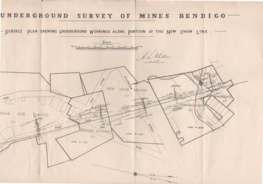 Bendigo Historical Society Inc.
Map - STRUGNELL COLLECTION: NEW CHUM LINE, 25/5/01
Map, Surface Plan Showing underground workings along portion of the New Chum Line.South Belle Vue United, Eureka Extended, New Chum Railway, Shenandoah Co. Shamrock Co..A.S.Whitelawmap, bendigo, new chum line -
University of Melbourne, Burnley Campus Archives
Map - Topographic Survey, Ararat, 1970
Australia 1:100,000 Topographic Survey map of Ararat district, Victoria dated 1970. Sheet 7423 (Edition 1) Series R 652. Produced by the Royal Australian Survey Corps.royal australian survey corps, ararat area, stawell area