Showing 16203 items
matching '' place
-
 Kew Historical Society Inc
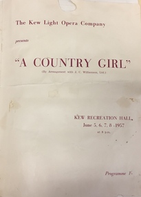
Programme, Kew Light Opera Company, A Country Girl, 1957
The Kew Light Opera Company was formed in 1952, and mounted a number of musical and variety productions each year until it was subsumed in the "Q" Theatre Guild in 1957. Most of the Company's performances took place in the Kew Recreation Hall in Wellington Street, Kew. A list of its productions by year includes: 1952 Florodora 1953 The Cingalee 1953 San Toy OR The Emperor’s Own 1953 Celebratory variety performance 195? While the Sun Shines 1954 A Country Girl 1954 Our Miss Gibbs 1955 The Toreador 1955 The Arcadians 1956 The Maid of the Mountains 1956 Whiteoaks 1956 Good night Vienna! 1957 A Country GirlThe Marion Tilley scrapbook is a significant record of performing arts in Melbourne during the 1950s and 1960s. The scrapbook includes programmes, photographs, newspaper reports and personal annotations which are a rich source of detail about repertoire, performers, and artistic sensibility in the period.Souvenir programme isued by The Kew Light Opera Company for a revival of 'A Country Girl' by Lionel Monckton. Performances were held in the Kew Recreation Hall in 5, 6, 7, 8 June 1957. The programme forms part of a scrapbook that includes programmes, photographs and theatre reviews for the Kew Light Opera Company and later "Q" Theatre Guild.theatre (kew), theatre groups (kew), performing arts, kew recreation hall, a country girl (musical) -
 Federation University Art Collection
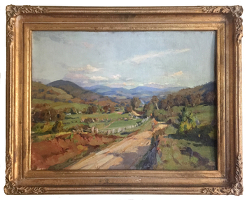
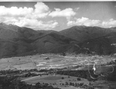
Painting, 'Road to Tallangatta' by Max Middleton, 1956
Max MIDDLETON (1922-2013) Born Melbourne In a career spanning 60 years, Max Middleton is known as a 'plein air' landscape painter the artist loved to paint sunrises, aiming to capture what he saw on the spot in paint. Capturing the light was crucial to his artworks. Max Middleton studied Drawing at the National Gallery School under William Rowell in 1938, and painting under Harold Septimus Power in 1940. The first of Middleton's 68 professional exhibitions took place in 1946. This item is part of the Federation University Art Collection. The Art Collection features over 1000 works and was listed as a 'Ballarat Treasure' in 2007.Framed oil painting of a landscape near Tallangatta.art, artwork, max middleton, landscape, tallangatta, available, middleton, oil on canvas -
 Port Fairy Historical Society Museum and Archives
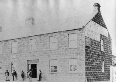
Photograph
John J. Huntly appears to have been the only licensee of the Royal Oak Hotel, built in 1858. Commercial Hotel Bank Street Port Fairy Formerly known as The Royal Oak and then renamed The Royal Oak in the 1990's. A verandah was added in 1900. Around 1877 the hotel various rooms for visiting doctors and a dentist. Dr Berncastle who was associated with the Sydney Eye Infirmary performed several operations there on those suffering from cataracts. It was the meeting place for the Port Fairy Freemasons, before their lodge was built in James Street and all local sporting clubs at one time or another. Also a Cobb & Co staging post.Large Black and white Photograph of the Commercial Hotel Left hand top corner in Ball point pen- PRESENTED BY MR RON McLEAN Right hand top corner in pen - COMMERCIAL HOTEL Museum Number - 62.04B.012hotel, bank street, port fairy, doctor berncastle, commercial, royal oak, sydney eye infirmary, freemasons, lodge, cobb and co, livery stables -
 Bacchus Marsh & District Historical Society
Plaque, Shire of Bacchus Marsh Coat of Arms
Coat of Arms used by the Shire of Bacchus Marsh in the 1980s and 1990s. A coat of arms has been in use in the Shire at least from the early 20th century. This earlier coat of arms described in 1910 featured two cows standing on two bales of lucerne hay, with lucerne fields and fruit trees and rolling hills all round a central valley with two rivers running through it. This early coat of arms was superseded by the slightly different design shown here. When this change took place is not known. When the Bacchus Marsh Shire amalgamated with other Shires to form Moorabool Shire in 1994 this design was superseded.The plaque showing the Bacchus Marsh Shire Coat of Arms is in near perfect condition and as such is an excellent example of the physical symbols used to demonstrate the presence of local government in the Bacchus Marsh region. The images on the coat of arms also depict key economic and agricultural activities in the region which provides historical information about the region in a visual and artistic way.Painted cast bronze plaque with inscription on outer white band in black capital lettering: SHIRE OF BACCHUS MARSH. Inner circle painted blue with shield and decorative branches bearing yellow leaves on either side. Shield quartered and surmounted by stylised sunrise. In four quarters, representations of significant local primary and secondary industries. SHIRE OF BACCHUS MARSH.coats of arms, shire of bacchus marsh -
 Wodonga & District Historical Society Inc
Album - Ringer's River by Des Martin - Plate 32 - The shooting of Nugent
Advised of the tragedy by one of the stockmen Ellen O'Hara drives the gig towards Overton, but meets Klinberg who tells her the police have found a body near Nugent's place. Ellen gets there as Nugent is pulling Keiran's body from the river. Shock grief, and old bitternesses unhinge her mind. Seizing Trooper Ryan's pistol from on top of his clothes she shoots Nugent dead, and bolts up a rough back track towards her home with the police in pursuit. Her pony falls while belting along a narrow, dangerous piece of the track, and the gig goes over a cliff. Ellen is killed.The album and images are significant because they document literature written by a prominent member of the Wodonga community. The presentation of this precis was supported by several significant district families and individuals.Ringer's River Album Coloured photo Plate 32des martin, many a mile, ringer's river, northeast victoria stories -
 Melbourne Legacy
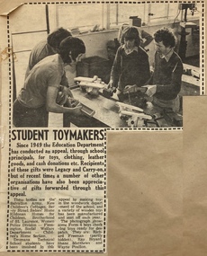
Newspaper - Article, Student Toymakers, 1977
An article from 1977 about a scheme by the Education department whereby toys are donated to charities such as Legacy which was in place since 1949. Sometimes these toys and clothing were given to junior legatees at the Christmas party. The photo shows four boys from Dromana Technical School making toys in their woodworking class. They are Richard Freeman, Ray Bryant, Shane Matthews and Wayne Poulton. The article was cut from the newspaper and pasted into a scrapbook. For many years Legacy kept scrapbooks of press clippings that related to their work and publicity. Not all pages have been listed individually but some are listed from 02164 to 02176.A record of the scheme that provided gifts for Junior Legatees for many years since 1949.Newspaper article about school boys donating toys made in 1977 pasted to brown page of a scrapbook.christmas, christmas gifts, donations -
 Wooragee Landcare Group
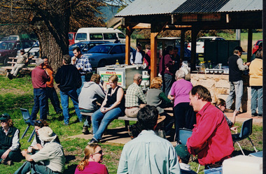
Photograph, 27th August 2004
Taken on the 27th August 2004 the photographs shows attendees of the Direct Seeding Expo that took place at Wooragee Hall socialising and eating during a lunch break. Direct seeding involves the seeds being sowed directly into the soil to achieve germination and establishment. Direct seeding is said to mimic natural processes and can result in trees and shrubs growing healthier root systems. Direct seeding is best for larger areas and can be done at a lower cost. As the Wooragee community values nature, this expo brought together members from the community in order the educate them on direct seeding which would then benefit the community. This photograph is significant at the Wooragee community values nature and believes in replacing what has been lost. Thus, the photograph demonstrates the communities commitment to ensuring the preservation of nature through education of seeding practices.Coloured rectangular photograph printed on gloss photographic paper Reverse: WAN NA E0NA2N2. NNN 0 3585 (No.22) 347wooragee, wooragee landcare, direct seeding expo, 2004 -
 Merri-bek City Council
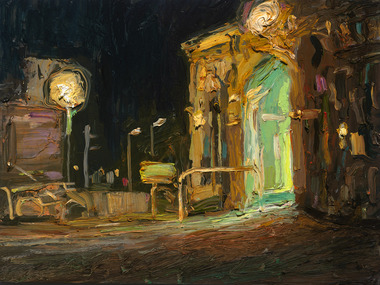
Oil on board, Shaun Tan, Jewell Station, Night, 2016
Shaun Tan is best known for his illustrated books and short films that deal with social, political and historical subjects through dream-like imagery and fantastic creatures. In addition to his book and film work, Tan is a respected and prolific painter. Tan’s paintings capture a sense of place and atmosphere, even when the specific location is not made explicit. Tan says of his practice: “Often I don’t know why I need to paint a certain scene, only that I do, as if to stop it from drifting away too quickly, to just allow a little more time to think about it. Or to just say ‘I saw this’”. -
 Melbourne Tram Museum
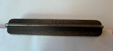
Functional object - Sandringham tramway - section staff, 1920s
Item used on the Victorian Railways Sandringham - Black Rock tram line for the short section of the single track of the line between the railway station in Station Street and the depot entrance in Bay Road. Tram drivers were required to carry this to prevent a head-on collision on the single-line section. Image 3 shows the driver placing the item in the "staff box" outside the depot. Image from the DVD "VR Tramways in the 1950s", with permission from Effectch the Producer. The Newport Railway Museum holds the other staffs for this line along with a damaged one (or two) for the same section - see photo 4 for the Black Rock to Beaumaris Section.Demonstrates an item used to safely work trams on the Sandringham - Black Rock - Beaumaris tram line.Two sections of steel intermeshed to form a cross and stamped.Stamped "No. 1 Section" and "Sandringham - Staff Box"trams, tramways, safeworking, sandringham, section staff -
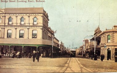 Ballarat Tramway Museum
Postcard, John Phillips and Rose Stereograph Co, Bridge St (Looking East), Ballarat, c1905
Image is an ESCo tram leaving the intersection of Grenville St. and Bridge St. and proceeding east along Bridge St. Photo taken behind junction points. Has the Nicholl & Allan building on the left side of the photo and the Bucks Head Hotel on the right. Numerous people walking around the street. Shows overhead construction in the area. Title in top left-hand corner "Bridge St. (Looking East), Ballarat. On the rear is places for stamp, address and manufacturer's name in a fancy motif "WTP". Photo taken soon after opening, no roof-mounted destination boxes. See item 9010 for a printed version. yields information of Bridge St at Grenville St, c1905B&W print, laser print and scanned images of a coloured postcard lent to the BTM by Mr. Norm DePomeroy, August 1998 and Sovereign Hill reproduction of this card contained within a scrap book. See Notes for various image holdings and history.trams, tramways, esco, sturt st, postcards, bridge st., grenville st -
 City of Greater Bendigo - Civic Collection
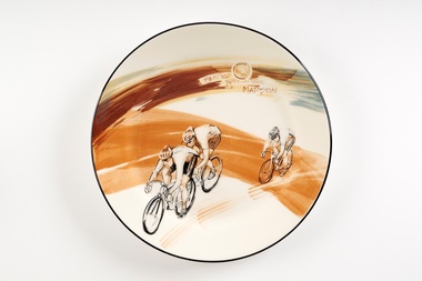
Souvenir - Ceramic platter, Bendigo Pottery, Bendigo International Madison, 2009
First held in 1972 the Bendigo International Madison is an athletics and cycling carvial which takes place in Bendigo ove the March Labour Day long weekend. Events include 400m footraces and the largest outdoor Madison event in the world. The madison is a track cycling race in which 17 pairs of riders race over a hectic 200 laps of the Tom Flood Sports Centre in Bendigo. Riders firstly try to gain a lap advantage over other teams or score sprint points during the 34 sprints dotted throughout the race. At any one time, there are riders sprinting, changing or attacking in this frantic event.Large ceramic plate with hand painted design in underglaze depicting three men bicycle racing.Front; 2009 / Bendigo International Madison Reverse; Signed Faye Brady / 09. Stamped; Bendigo Pottery / 1858 / Australiabendigo pottery, city of greater bendigo sport, city of greater bendigo tourism -
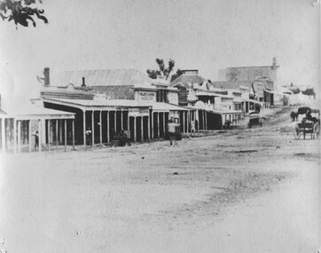 The Beechworth Burke Museum
Photograph, 1859
Taken in Beechworth 1859, this photograph depicts the south side of Ford street looking towards the Methodist Church. The Methodist Church was built in 1857, and was the first permanent church building on the Ovens goldfields. It was one of the first permanent churches built on the Victorian goldfields, and the first on the Ovens goldfield. It demonstrates the rapid development which occurred in the goldfield towns following the discovery of gold in the early 1850s. It reflects the importance of Methodism in Victoria at this time, and the early activities of the Wesleyan Methodist Church in taking their religious message to the gold miners. [https://vhd.heritagecouncil.vic.gov.au/places/104] The buildings ceased being used as a church in 1966 when the Methodist and Congregational churches in Beechworth amalgamated.Black and white rectangular photograph. Image is printed on matte photographic paper. Obverse: NO INSCRIPTION Reverse: 7775 Ford St Looking Southwest 1859 Burke Museum Beechworth beechworth, ford street, methodist church, 1859 -
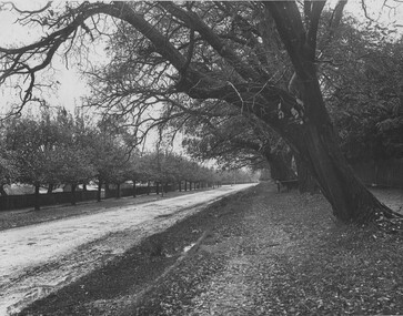 The Beechworth Burke Museum
Photograph
This photograph was taken of an avenuw of acacias on Sydney Rd, Beechworth. Picture on the left hand-side is a row of Liquidamber trees also known as American storax, hazel pine, bilsted, redgum, satin-walnut, star-leaved gum, alligatorwood, or simply sweetgum. On the right is a row of English Oak trees commonly known as common oak, pedunculate oak, or European oak. Behind the English oaks is Old Beechworth Goal. Many of the trees in the Beechworth township were planted in the 1860's and today have exceptional historical, botanical or cultural value. Their place within the built environment reflects the importance in the Victorian era of town planning for a community, wealthy in gold and civic pride.Black and white rectangular photograph. The image is printed on gloss photographic paper and mounted on cardboard. Obverse: NO INSCRIPTION Reverse: 7760 The old Acacia Avenue alongside the jail. Sydney Road Beechworth Gardens & Parks beechworth, acacia avenue, gaol, sydney road, burke museum, photograph, post card, english oak, liquidambar -
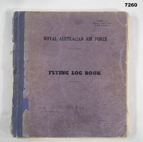 Bendigo Military Museum
Document - LOG BOOK, FLYING, RAAF, 1942
Ronald Leslie Schorey Dickinson RAAF No 439212. He initially enlisted as a RAAF Cadet age 16 years on 27.2.1942, Cpl 17.11.1942, Sgt 17.6.1943, S/Sgt 8.10.1943. At age 18 he enlists on 29.2.1944 with the rank A/C 2 and soon with the rank LAC (leading Aircraftsman). He is posted to places like Geraldton & Kalgoorlie WA, Benalla & Tocumwal VIC. From 23.9.1945 he is listed with postings at 54 Mile NT, Darwin in two different units, Winellie and Ransford. He is discharged with the rank of LAC on 20.5.1946. Records are hard to follow but it appears he could have been Aircrew as an LAC. Refer also Cat No 7263PThis is a hard cover book. The colour of the front cover is a purplish hue. The spine has a blue buckram binding. It was Airforce Form A.18. Inside are a large number of pages covering such subjects as; Pilot Certification, Aircraft flown, Hours, Locations. Dates - range from 1944-2017. Possibly some pages are missing. 1942 - 1944. It has records for RAAF Flying and Civilian Flying Post WW2.Written on bottom of book pages is name "DICKINSON R.L.S.raaf, flying log -
 Warrnambool and District Historical Society Inc.
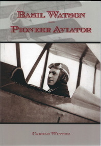
Book, Basil Watson, March 2015
This book gives details on the life and work of Basil Watson (1893-1917), a pioneer aviator in Australia. From 1914 to 1916 he worked in England for the Sopwith Aviation Company, receiving training in the workshops and becoming a test pilot. Back in Australia Watson commenced building his own plane in the billiard room at his parents’ home in Brighton, Victoria. He flew this plane to Bendigo, Warrnambool, Hamilton, Camperdown, Casterton and Mount Gambier and carried the first official airmail to these places. He also gave exhibitions of aerial flying stunts at these towns. He died when he crashed into the sea near Point Cook in March 1917.This book is of some importance to Warrnambool as it tells the story of Basil Watson who was the first person to fly to Warrnambool in January 1917. On this occasion he performed aerial stunts in front of a large crowd at the Warrnambool Racecourse and brought three letters to the Mayor of Warrnambool, thus being the bearer of the first aerial post to this city. The book includes several photographs and posters of Watson’s time in Warrnambool. The Warrnambool and District Historical Society has several mementos of Watson’s flight, including one of his original letters and the seat This is a paper back book with a plastic-laminated cover. There are 61 pages with diagrams, photographs, illustrations, advertisements, posters and newspaper cuttings. The cover is mainly grey and white in colour with printed material in a red insert and two photographs superimposed over the background.Front cover: Basil Watson – Pioneer Aviator- Carole Winter Back cover: Printed material (summary of book’s contents) PenFolk Publishing, Blackburn, March 2015 ISBN 978 1 875894 95 6 basil watson, warrnambool and aviation pioneer -
 Warrnambool and District Historical Society Inc.
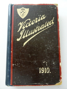
Book, Victoria Illustrated 1910 x 3, 1910
These are three copies of ‘Victoria Illustrated’, a publication issued in 1910 by the Victorian Government containing information and photographs of places in Victoria. There are fifteen pages describing Warrnambool. One copy belonged to Bert and Henri Worland. It is presumed that Bert was the older brother of Henri Worland, the Town Clerk of Warrnambool from 1918 to 1949. Henri Worland was one of Warrnambool’s most important historians and was responsible for collecting much of the historical material that is now in the possession of the Warrnambool and District Historical Society. He also wrote about Warrnambol’s history and was well-known in the 1940s for his 3YB radio broadcasts about Warrnambool’s history. His brother Albert was an insurance agent in Warrnambool. This book is of considerable importance as the material on Warrnambool and district covering the year 1910 is of great interest to historians today and is much used. There is a wealth of information on many Warrnambool businesses at that time. The connection with the Worland family is also of interest. These three copies of ‘Victoria Illustrated’ contain information on Victoria early in the 20th century and contain printed text, many black and white photographs and illustrations and advertisements for Victorian businesses. .1 A hard cover book with a dark blue cover and a pasted brown covering on the front and back cover. The front cover has white lettering and an image of a shield with a crown and the Southern Cross and the back cover has an illustrated advertisement for Buchanan’s Whisky. The inscriptions are handwritten in blue ink. .2 The cover is completely detached and the spine is missing. There are 14 pages missing at the end of the book. .3 The cover is missing with a photocopied front page. The outside pages are tattered and three pages are missing from the back. .1 - ‘W.P.T. to Bert & Henri Worland’ ‘H. Worland’ history of warrnambool, henri and albert worland -
 Kiewa Valley Historical Society
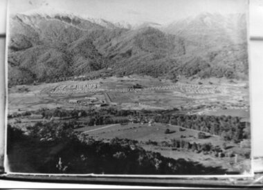
Photograph - Mt Beauty Camp, Estimated 1950-1951
This photo is of the very newly constructed State Electricity Commission town of Mt. Beauty. The houses up to Nelse street were erected from 1946 onward and then the township was extended beyond Nelse Street in 1950 which places this photograph about 1950/51. There is no evidence of work being commenced on the regulating pondage but the tail race canal can be seen on the centre right of photo. The workmen's camp was enlarged in 1950 to the extent of providing accommodation for a total of 1,200. There are a number of dwellings on Simmonds Creek and the road to Falls Creek can clearly be seen. Snow capped Mt. Bogong is in the upper left of the photo with Mt. Beauty behind the township rising to Big Hill beyond that.Shows the newly constructed town of Mt. Beauty surrounded by farmland and before the regulating pondage was built to discharge water from the power stations via the West Kiewa tail race tunnel into the Kiewa River. Copy of black and white photograph of Mt Beauty CampWritten on the back in black ink - A Campenmt beauty camp, secv, construction town -
 Eltham District Historical Society Inc
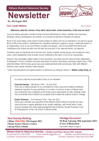
Journal - Newsletter, Newsletter, No. 265 August 2022, Aug 2022
Contents: • Our Local History by Jim Connor • Our Next Meeting – 2.00pm Saturday 13th August 2022 • Heritage Excursion – A Tour of Montsalvat - Saturday 10th September • Gordon Ford by Barry Pearce • OM:NI Eltham by Jim Connor • A Yarning Circle – A Gathering Place by Jim Connor • Annie Chases a Tinkler; October 3, 1902, Evelyn Observer, and South and East Bourke Record, p. 2 • Health Inspector Report from Eltham Shire Council meeting – 1932 • J.H. Clark - photographer by Peter Pidgeon • Harcourt Hill by Carlota Quinlan • Eltham Cemetery Stories by Liz Pidgeon o Margaret Sweeney, nee MeehanThe Shire of Eltham Historical Society was formed in October 1967. The first newsletter of the Society was issued May 1978 and has been published continuously ever since on a bi-monthly basis. With the cessation of the Shire of Eltham in late 1994, the Society's name was revised to Eltham District Historical Society and this name first appeared with issue No. 103, July 1995. The collection of the Society's newsletters provides a valuable resource on the history of the Society's activities, office bearers and committee members, guest speakers and subjects of historical interest pertinent to the former Shire of Eltham and the Eltham District.A4 newsletter distributed to members (Digital and A4 photocopy)newsletter, eltham district historical society -
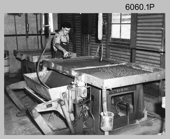 Bendigo Military Museum
Photograph - Lithographic Technicians Preparing Printing Plates at the Army Survey Regiment, c1960s to c1980s
These eight photographs were most likely taken from the 1960s to the 1980s in Lithographic Squadron at the Army Survey Regiment, Fortuna, Bendigo. Photos .1P, .7P, and .8P are not annotated although .7P and .8P are positively identified. The others have the name of the technicians written on the back. In these photos the technician preparing printing plates for offset printing. The Printing Technician in photo .1P is resurfacing a zinc printing plate with ball bearings. In photos .2P to .6P the Printing Technicians are applying a light sensitive coating on the printing plate. In photos .7P and .8P the Printing Technicians are placing a map negative on top of the printing plate in a vacuum frame before light exposure. This is a set of photographs of lithographic technicians preparing printing plates at the Army Survey Regiment, Bendigo from c1960s to c1980s. The photographs were printed on photographic paper and are part of the Army Survey Regiment’s Collection. The photographs were scanned at 300 dpi. .1) - Photo, black & white, c1960s, SPR Bruce, Lithographic Squadron .2) - Photo, black & white, c1970s, Lance Percey, Lithographic Squadron .3) - Photo, black & white, c1970s, LCPL Col Hardisty, Lithographic Squadron .4) - Photo, black & white, c1970s, SPR Dave Edwards, Lithographic Squadron .5) - Photo, colour, c1970s, John Cain, Lithographic Squadron .6) - Photo, colour, c1970s, SGT Ken Slater, Lithographic Squadron .7) - Photo, black & white, c1980s, Roy Hicks, Lithographic Squadron .8) - Photo, black & white, c1980s, CPL Gary Drummond, Lithographic Squadron.1P - annotated 'SPR Bruce' on back of dupicate photo located in Volume 7 folder. .2 to .7 – personnel names (less rank) annotated on back. .8P – no annotationroyal australian survey corps, rasvy, army survey regiment, army svy regt, fortuna, asr, printing, litho -
 City of Moorabbin Historical Society (Operating the Box Cottage Museum)
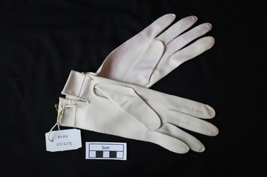
Clothing - Clothing. lady's nylon gloves 'Simplex', c1960
These gloves are made from a warp-knitted cotton fabric called ' Simplex'. Cotton simplex is stronger than jersey (another knitted fabric) and does not fray. This makes it perfect for hand-sewn gloves. The gloves were made in Hong Kong then as now a place where fashions can be made cheaply because the cost of labour is inexpensive. Ladies' gloves for formal and semi-formal wear come in three lengths for women: wrist, elbow, and opera or full-length (over the elbow, usually reaching to the biceps but sometimes to the full length of the arm). In the late 19thC and early 20thC Gloves were expected to be worn for both daytime and evening wear with most types of outfits. The family of Carole Pedersen-Green were early settlers in Moorabbin Shire and their Danish heritage is an example of the many nationalities who lived and worked there.A pair of lady's short cream nylon gloves ' Simplex' Size 7 C 1960SIMPLEX NYLON 7clothing, gloves, formal wear, craftwork, lace making, dress etiquette, satin, silk, simplex material, hong kong, moorabbin, bentleigh, cheltenham, fashion, denmark, pedersen-green carole, green carole -
 Eltham District Historical Society Inc
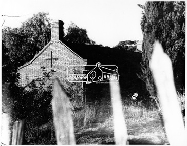
Negative - Photograph, George W. Bell, Shillinglaw Cottage, Main Road, Eltham, c.1964
Shillinglaw Cottage on its original site (present day 895 Main Road) showing old picket fence c.1964. The cottage and land were purchased by the Shire of Eltham as the site for a new shire office building. The cottage was destined for demolition but members of the community concerned at losing one of the areas earlist buildings (built c.1859) initiated a fund-raising campaign to save the cottage. In 1964 the cottage was dis-assembled, all the bricks numbered and reassembled several hundred meters to the south on a site between the Gahan house and the Eltham Railway Trestle Bridge (present-day Panther Place), which bcame known as the Eltham Common.This photo forms part of a collection of photographs gathered by the Shire of Eltham for their centenary project book,"Pioneers and Painters: 100 years of the Shire of Eltham" by Alan Marshall (1971). The collection of over 500 images is held in partnership between Eltham District Historical Society and Yarra Plenty Regional Library (Eltham Library) and is now formally known as the 'The Shire of Eltham Pioneers Photograph Collection.' It is significant in being the first community sourced collection representing the places and people of the Shire's first one hundred years.Digital image 4 x 5 inch B&W Negsepp, shire of eltham pioneers photograph collection, eltham, shillinglaw cottage, fences, george w. bell collection, houses, main road -
 Eltham District Historical Society Inc
Negative - Photograph, George W. Bell, Shillinglaw Cottage, Main Road, Eltham, c.1964
Shillinglaw Cottage on its original site (present day 895 Main Road) showing old picket fence c.1964. The cottage and land were purchased by the Shire of Eltham as the site for a new shire office building. The cottage was destined for demolition but members of the community concerned at losing one of the areas earlist buildings (built c.1859) initiated a fund-raising campaign to save the cottage. In 1964 the cottage was dis-assembled, all the bricks numbered and reassembled several hundred meters to the south on a site between the Gahan house and the Eltham Railway Trestle Bridge (present-day Panther Place), which bcame known as the Eltham Common.This photo forms part of a collection of photographs gathered by the Shire of Eltham for their centenary project book,"Pioneers and Painters: 100 years of the Shire of Eltham" by Alan Marshall (1971). The collection of over 500 images is held in partnership between Eltham District Historical Society and Yarra Plenty Regional Library (Eltham Library) and is now formally known as the 'The Shire of Eltham Pioneers Photograph Collection.' It is significant in being the first community sourced collection representing the places and people of the Shire's first one hundred years.Digital image 4 x 5 inch B&W Negsepp, shire of eltham pioneers photograph collection, eltham, shillinglaw cottage, fences, george w. bell collection, houses, main road -
 Kiewa Valley Historical Society
Photograph of Mt. Beauty, Mt. Beauty from transmission line, Approx 1950/51
This photo is of the very newly constructed State Electricity Commission town of Mt. Beauty. The houses up to Nelse street were erected from 1946 onward and then the township was extended beyond Nelse Street in 1950 which places this photograph about 1950/51. There is no evidence of work being commenced on the regulating pondage but the tail race canal can be seen on the centre right of photo. The workmen's camp was enlarged in 1950 to the extent of providing accommodation for a total of 1,200. There are a number of dwellings on Simmonds Creek and the road to Falls Creek can clearly be seen. Snow capped Mt. Bogong is in the upper left of the photo with Mt. Beauty behind the township rising to Big Hill beyond that.Shows the newly constructed town of Mt. Beauty surrounded by farmland and before the regulating pondage was built to discharge water from the power stations via the West Kiewa tail race tunnel into the Kiewa River. Black and white photographHand written on back of photograph "Mt. Beauty from Transmission Line"mt. beauty, construction, pondage, state electricity commission -
 Eltham District Historical Society Inc
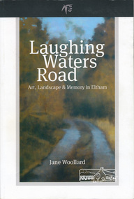
Book, Shire of Nillumbik, Laughing Waters Road: art, landscape & memory by Jane Woollard, 2016
"Laughing Waters has been a source of inspiration for many artists and designers, and was a natural extension of the dynamic art and lifestyle movement that began in the 1930s at Montsalvat. It was also an important site in the development of the Melbourne art scene in the 1960s and '70s, especially the earth building movement known as the Eltham Style. Since 2001 more than eighty artists have been in residence at Laughing Waters in Birrarung House and Riverbend. Their experiences and art making are woven together with Wurundjeri, European and family histories to create an evocative account of a special place in a bushy outer suburb of Melbourne." -- back cover. Eltham District Historical Society is acknowledged in the Acknowledgments section of this book.264 pages : illustrations, maps, portraits ISBN 9780994486707laughing waters, eltham, yarra river, artists, killeavey, mud bricks -
 Warrnambool and District Historical Society Inc.
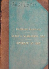
Document - Victorian Railways. Koroit & Warrnambool Line. Contract No. 2937, Circa 1888
The Victorian Railways began in 1854 and in the first 14 years up to 1868 had managed to complete about 250 miles of track. The next 60 years saw the system expand to nearly 3000 miles. By 1931 every town with a population over 500 had its own railway station. Early Victorian railway maps indicate that the extension from Colac to Warrnambool and then onwards to Koroit, occurred in the period of the 1880’s when the act known as the Octopus act saw a rapid expansion of lines. At the time there was much debate over where the expansion of the lines should take place, with one of the prime considerations for Warrnambool was the impact it would have on its port.The building of the railway to Warrnambool and onward to Koroit was a significant event for the town. Green cloth cover with tan suede corner points and spine. Title printed in gold on front cover. Title printed in gold on red on spine. 92 pages. The contract is printed and includes handwritten entries with specifications.Handwritten on front cover and inside front cover ” Copy for Engr in Chief” .On Page 2 transferred to Allan Reid * 24/1/88 Co Briscoe & Co Little Collins Street, Melbourne.warrnambool, railways, warrnambool to koroit railway, victorian railways contract no 2937 -
 Orbost & District Historical Society
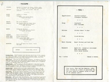
program, 1978
This program was for an event to celebrate the golden anniversary 950 years) of the official opening of Orbost's Commonwealth Hotel. It was organised by Chas and Una Roberts (nee Marshall) and was a fund-raiser for O.C.C.A. (Orbost Continuing Care}). This group was initiated by Brenda Murray who was the founding chairperson of the Orbost Continuing Care Appeal, which raised money to build an aged persons' facility for Orbost. The evening was compered by Graeme Eddy. The performers included: Victoria Strait, Leslie Strait, Norma Williams, Pauline Strait, Hoard Oberg and Wayne Stuart. All were accomplished musicians from New South Wales. The event took place at 6pm on Saturday September 2 1978.This item is associated with the Commonwealth Hotel which has been operating in Orbost since January 1901.A white paper program with black print.It is one sheet folded.On the back is a picture of the Commonwealth Hotel, Orbost with a brief history of its establishment underneath the photograph. On the front side is the title, "an evening of baroque music and a golden invitation to dinner". There is a stylised drawing of a saxophoene, drum and cello. Inside are details of the program and menu with notes on some of the performers.on front - "MUSEUM".commonwealth-hotel music-concert event-orbost -
 Orbost & District Historical Society
ledger, LOAN ACCOUNT CASH BOOK SHIRE OF ORBOST, 1935-1971
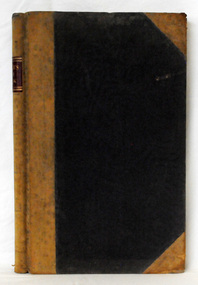
This ledger was used by the Shire of Orbost from 1935-1971. The item was donated to Orbost & District Historical society from P.R.O.V. as a Place of Deposit (POD) item for safe keeping by a local history group or museum. The shire covered an area of 9,347 square kilometres and existed from 1892 until 1994 when it became part of the East Gippsland Shire Council. Orbost was at first included in the Bairnsdale Shire from 1882 and was later part of the Tambo Shire. Because of travelling distances the Croajingalong Shire was created in 1892 (name changed to Orbost Shire 17.2.1893 with James Cameron as the first Shire President. In 1994 it amalgamated to become part of East Gippsland Shire Council. This item comprises records that belonged to the local government accounting system. The Shire of Orbost Council no longer exists having been absorbed by the East Gippsland Shire Council. This is a hand-written record created before the widespread use of computer accounting records.A black, hard cover ledger with light brown leather binding. it is titled "CASh BOOK LOAN ACCOUNT, SHIRE OF ORBOST". Records are hand-written. Inside the back cover is a loose-leaf typed document titled, "Shire Engineers Report 11 Sept 1970".cash-book ledger shire-of-orbost accounting -
 Orbost & District Historical Society
ledger, TREASURER'S CASH BOOK, 1898 - 1912
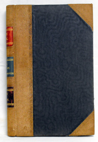
This ledger was used by the Shire of Orbost from 1898 to 1912. The item was donated to Orbost & District Historical society from P.R.O.V. as a Place of Deposit (POD) item for safe keeping by a local history group or museum. The shire covered an area of 9,347 square kilometres and existed from 1892 until 1994 when it became part of the East Gippsland Shire Council. Orbost was at first included in the Bairnsdale Shire from 1882 and was later part of the Tambo Shire. Because of travelling distances the Croajingalong Shire was created in 1892 (name changed to Orbost Shire 17.2.1893 with James Cameron as the first Shire President. In 1994 it amalgamated to become part of East Gippsland Shire Council. This item contains handwritten accounting records of the Shire of Orbost. The Orbost Shire local government no longer exists as it was absorbed by the East Gippsland Shire Council.A black, hard cover ledger with light brown leather binding. It is titled "TREASURER'S CASH BOOK" and contains hand-written records.orbost-shire-council ledger-accounts -
 Orbost & District Historical Society
ledger, 1950's
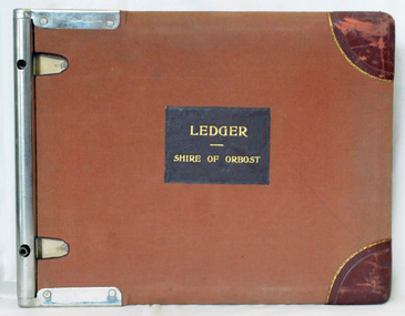
This ledger was used by the Shire of Orbost in 1959. The item was donated to Orbost & District Historical society from P.R.O.V. as a Place of Deposit (POD) item for safe keeping by a local history group or museum. The shire covered an area of 9,347 square kilometres and existed from 1892 until 1994 when it became part of the East Gippsland Shire Council. Orbost was at first included in the Bairnsdale Shire from 1882 and was later part of the Tambo Shire. Because of travelling distances the Croajingalong Shire was created in 1892 (name changed to Orbost Shire 17.2.1893 with James Cameron as the first Shire President. In 1994 it amalgamated to become part of East Gippsland Shire Council. This is a handwritten record of revenue accounts from local government. The Shire of Orbost as a local government no longer exists havinb absobed into the East Gippsland Shire Council.A heavy ledger with a brown cover and steel bindings. The covers are probably wooden. It is alphabetically indexed and the ledger is lockable. it contains revenue accounts for 1959. On the front cover is "LEDGER (underlined) SHIRE OF ORBOST" in gold print. It is an "Emu Binder".accounts-shire-of-orbost local-government -
 Orbost & District Historical Society
ledger, first half 20th century
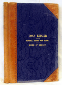
This ledger was used by the Shire of Orbost from 1927 -1940. The item was donated to Orbost & District Historical society from P.R.O.V. as a Place of Deposit (POD) item for safe keeping by a local history group or museum. The shire covered an area of 9,347 square kilometres and existed from 1892 until 1994 when it became part of the East Gippsland Shire Council. Orbost was at first included in the Bairnsdale Shire from 1882 and was later part of the Tambo Shire. Because of travelling distances the Croajingalong Shire was created in 1892 (name changed to Orbost Shire 17.2.1893 with James Cameron as the first Shire President. In 1994 it amalgamated to become part of East Gippsland Shire Council. This item is a handwritten record of the accounts of the Orbost Shire local government. It pre-dates computer records. The Orbost Shire Council no longer exists having been absorbed by the East Gippsland Shire Council.A ledger with a black cover and brown leather binding. It has marbled end pages. On the front cover in gold print is " LOAN LEDGER (underlined) NEWMERELLA DRAINAGE AREA ACCOUNT (underlined) SHIRE OF ORBOST.on spine - "Newmerella Drainage Area Loan Ledger"ledger orbost-shire newmerella-drainage-area accounts