Showing 11430 items
matching maps
-
 Mission to Seafarers Victoria
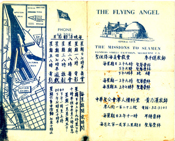
Flyer, Victorian Seamen's Mission, The Flying Angel, 1963-1966
The Mission accommodated seamen from all nationalities from the earliest days of operation. Asian seafarers are recorded visiting the Mission from the late 19th C. onwards. The first Chinese chaplain to be appointed was Rev Steven Wong who moved to Melbourne in the 1960s. Rev Wong served from 1963-1966 and according to his sons helped design these information brochures. Images of Rev'd Wong are included in the VC Database. The pamphlet gives days and times of activities such as dances and films and chapel services. The Chinese writing was made by Reverend Stephen WongA rare surviving period example of a non-english speaking flyer on information about the Mission to Seafarers Victoria Commercially printed paper single fold flyer providing directions and information to the Central Club, Missions to Seamen at Flinders St extension, in Mandarin. Contains a drawing of the central mission and a map of Docklands.In English: CENTRAL CLUB/THE MISSIONS TO SEAMEN, FLINDERS STREET EXTENSION, MELBOURNE C.3 In Mandarin: Translation (from Google translate): date and time of services / date and time for dances, movie sessions, teareverend stephen wong, mandarin, chinese, asian, reverend perry mitchinson -
 Ringwood and District Historical Society
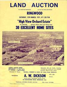
Flyer, Land Auction Sale Brochure, High View Orchard Estate, Ringwood, Vic. - 1971
Double-sided advertisement for Ringwood High View Orchard Estate land auction sale on Saturday, 13th March, 1971, including aerial photograph, map, and summary of local facilities and services.Subdivision includes Wonga Road, Oban Road, Sang Court, Ambrie Avenue, Hendra Grove, and Mullum Mullum Road. Agent - A.W. Dickson Pty. Ltd., 136 Whitehorse Road, Ringwood, 3134. Telephones: 870 6000, 870 6007, 870 7016, after hours 870 6868. A separate copy of the advertisement includes a local newspaper follow-up clipping reports thirty home sites grossing $102,350 at the auction. -
 Port Melbourne Historical & Preservation Society
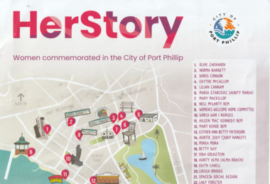
Flyer, City of Port Phillip, Her Story - Women commemorated in the City of Port Phillip, 2023
Her Story Celebrates women's stories and achievements in the City of Port PhillipA3 Sheet with title in red; a map of the City of Port Phillip with places associated with the women commemorated marked with red & white numbering. The Names of the women are listed and there is a QR code on the bottom right.local government - city of port phillip, olive zakarov, doris condon, edythe mccallum, norma barnett, lilian cannam, maria starcevic, mary mackillop, nell mclarty bem, aileen keenedy bem, mary kehoe bem, esther patterson, betty patterson, judy hanley, mirka mora, betty day, vida goldstein, alma roach, edith cavell, louisa briggs, lady forster, space 2b social design, world war 1 nurses, women's welcome home committee -
 Melbourne Tram Museum
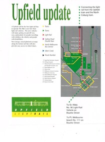
Magazine, "Upfield Update", c1989
Magazine cutting - form an unknown magazine - approx. A4, titled "Upfield update", giving an outline of the proposal, map, elevation of the proposed tramcar, and "benefits". Has an article about graffiti on the rear.trams, tramways, upfield light rail, railways, conversion, sydney rd, light rail -
 Melbourne Tram Museum
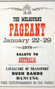
Poster, Victorian Government, "The Melbourne Pageant - January 22 - 29 1979 - Salute to Australia, Cavalcade of Transport", 1979
Poster - special size sheet, titled "The Melbourne Pageant - January 22 - 29 1979 - Salute to Australia, Cavalcade of Transport" advertising the planned events and dates with a map. Two copies held.trams, tramways, australia day, mmtb, melbourne, tramcars, pageant, melbourne pageant -
 Bendigo Historical Society Inc.
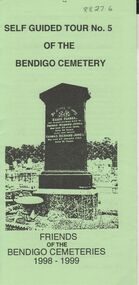
Document - BENDIGO CEMETERIES COLLECTION: SELF GUIDED TOUR NO. 5 DOCUMENT
BHS CollectionGreen trifold document: Self guided tour No. 5 of the Bendigo Cemetery, Friends of the Bendigo Cemeteries 1998 - 1999' Map of cemetery with numbered graves. Theme 'Heritage all around us'Friends of the Bendigo Cemetery 1998bendigo, cemetery, bendigo cemetery tour -
 Bendigo Historical Society Inc.
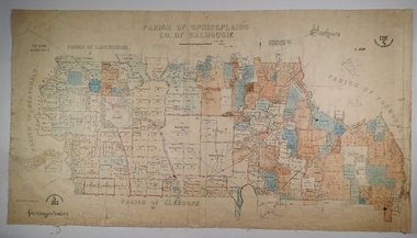
Map - SPRING PLAINS, Examined 31/01/1876
Map: Parish of Springplains, County of Dalhousie. Parish plan June 1874 A.D. Scott Examined E.D. 4.7.74 Additions made March 1877 Written in blue " See new plan."map, dalhousie, parish plan, spring plains, a. d. scott -
 Lakes Entrance Historical Society
Book, Howse, Derek and Sanderson, Michael, The Sea Chart, 1973
A sample collection of maps and charts showing the development of the sea chart from 1420 to a metric Admiralty chart of 1971. The sixty reproductions are of sea charts preserved in the National Maritime Museum, Greenwich.maritime history -
 Bendigo Military Museum
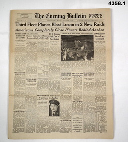
Newspaper - THE PHILIDELPHIA EVENING BULLETIN, 1944
.1) .2) Newspapers with local and state news with WW2 world news, sport articles and cartoons..1) U.S Newspaper of 8 pages, 2 small photos on front page. .2) U.S Newspaper of 8 pages, 2 small photos, 1 small map on front page..1) The Evening Bulletin, Philadelphia, Monday October 23, 1944. .2) The Evening Bulletin, Philadelphia, Monday, October 16, 1944news, headlines, sport, ww2, evening bulletin -
 National Vietnam Veterans Museum (NVVM)
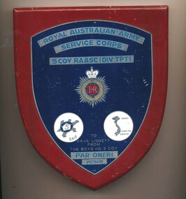
Plaque - 5 COY RAASC plaque
This item commemorates the war in Vietnam (1962-1972)Wood with metal insert, blue background with Royal Australian Army Service Corps badge, 5 COY RAASC (Div tpt) / Logo of tortoise with a 5 on its shell / map of VietnamRoyal Australian Army Service Corps 5 Coy RAASC (Div tpt)/ E11R/ Honi Soit Qui Mal Y Pense/ To Dave Liggett 3793526 from the boys HQ 5 Coy/ Par Oneri/ Vietnamdave liggett 3793526, 5 coy raasc (div tpt), royal australian army service corps, par oneri, vietnam, liggett, shield, plaque, emblem -
 Bendigo Military Museum
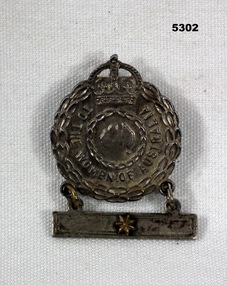
Badge - FEMALE RELATIVE BADGE WW2
Badge in WW2, Awarded to wife/mother/nearest female relative with family member serving overseas. One star represents one family member serving.Metal round badge with attached bar containing one star. Badge is topped with a crown and has a map of Australia in centre. Has pin on the back to attach to material. Colour is brown/bronze.Front has inscription "To the Women of Australia". Back has No. impressed A.243682. Also impressed on back issued by Cmwth Govt".ww2, female relative badge -
 Ringwood and District Historical Society
Document - Plan of Subdivision, Part of Crown Allotment 31B, Parish of Warrandyte - 1965
Map showing residential allotments numbered 1, 2, 4 and 5, on Through Road, Ringwood, Vic., with property dimensions, including weatherboard house and galvanised iron garage on lot 2.Kirkpatrick & Webber, Licensed Surveyors, Civil Engineers & Town Planners, Maroondah Highway, Ringwood, Telephone 8700321. Ref 3438C. Date 4th December, 1964. Amended 19th July, 1965. Notation: "The land coloured blue is a drainage and sewerage easement. Levels are to Board of Works Datum. Lot number 3 has been omitted." -
 Bendigo Historical Society Inc.
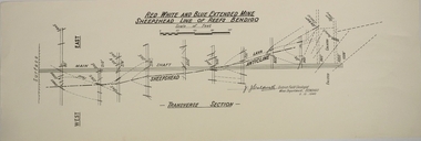
Map - RED WHITE AND BLUE EXTENDED MINE, 5/12/1940
Map: Transverse section of The Red, White and Blue Extended Mine, Sheepshead line of Reef, Bendigo. (9 Copies). By J.J. Caldwell, District Field Geologist, Mines Department Bendigo 5.12.1940map, bendigo, mining plan, red white and blue extended mine, sheepshead line of reef, mining , gold mines, j.j. caldwell -
 Bendigo Historical Society Inc.
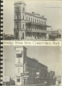
Book - BENDIGO URBAN AREA CONSERVATION STUDY, 1977
Bendigo Area Conservation Study - 192 pages with photos, illustrations and maps. Written on fron page ' 133 Mackenzie Street, Bendigo. Indecipherable signature with 'Bendigo, presented to RHSV Bendigo 1978'Lawrie Wilson & Associatesbendigo, buildings, conservation study, conservation, planning schemes, architecture, heritage houses -
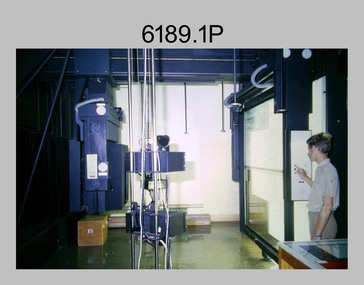 Bendigo Military Museum
Photograph - Photographic Technicians operating the KLIMSCH Camera at the Army Survey Regiment, Fortuna, c1980s
These four photographs were most likely taken in the mid-1980s in Lithographic Squadron at the Army Survey Regiment, Fortuna, Bendigo. The equipment operated by the technicians is the KLIMSCH camera. The main tasks undertaken by the technicians were most likely enlargements and reductions of map reproduction material. The KLIMSCH Commodore camera was introduced in 1953 and was the largest in the Southern Hemisphere. It was replaced with a new model of the same size in 1979. The new model with its computer-based interface provided productivity gains with improved speed and its consistent results led to less wastage in time and materials. Its variomat lens system provided improved retention of map feature linear weights during the camera reduction process. The camera which was specially made for the Army in Germany was fully automatic and power operated. It was claimed to be one of the biggest automatic cameras of its type in the world. It was made to the specifications of the Royal Australian Army Survey Corps to assist in the production of the very high standard maps for the Army. This is a set of four photographs of technicians operating the KLIMSCH Camera at the Army Headquarters Survey Regiment, Bendigo c1985. The photographs were on 35mm negative film and scanned at 96 dpi. They are part of the Army Survey Regiment’s Collection. .1) Photo, black & white, c1985, Frank Lenane operating the KLIMSCH Camera. .2) - Photo, black & white, c1985, KLIMSCH Camera. .3) to .4) - Photo, black & white, c1985, John Whaling operating the KLIMSCH Camera..1P to .4P – no annotationroyal australian survey corps, rasvy, army survey regiment, army svy regt, fortuna, asr, litho -
 Forests Commission Retired Personnel Association (FCRPA)
Drop Chute
From the early 1960s, the Forests Commission had pre-season arrangements in place with local aeroclubs and pilots across regional Victoria. Air observers from FCV districts routinely flew during the summer months in small, fixed-wing aircraft on fire spotting missions and to map fire boundaries. The information was often needed quickly by crews on the ground or in the control centre and these small chutes were used to drop messages and maps from the reconnaissance aircraft on a low pass above a cleared area like a football field. About 3-foot long when fully extended, they had a small pouch secured with a press stud for the map or package. The chutes were made from tough canvas with a small, weighted sandbag at one end and a long yellow streamer tail on the other to help direct its fall and locating it on the ground. Drop chutes were still in common use in the 1990s, but the increased availability of helicopters combined with improved digital data transfer made drop chutes redundant. Simple, but now redundant technologyAerial drop chute"Return to Forests Comm Vic" stenciled on sidebushfire -
 Bendigo Historical Society Inc.
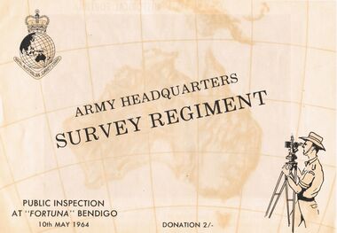
Document - ARMY HEADQUARTERS SURVEY REGIMENT, BENDIGO, 10 May, 1964
Army Headquarters Survey Regiment, Bendigo. Public Inspection at 'Fortuna', 10 May 1964. Donation 2/-. Includes photos of the Entrance Hall, Music Room and Villa. 3 army photos. In 1942 the mansion was occupied by the Australian Survey Corps and 'Fortuna' became the site of the base map production plant of the Australian Army for the remainder of the war years. During this period approximately sixteen million maps of Australian Territories and theatres of operation in the South West Pacific Area, were produced for use by the Allied Services. This function was continued as a peace time role in the post war years, and in 1951 ''Fortuna'' was purchased by the Commonwealth Government. As the largest unit of the Royal Australian Survey Corps, AHQ Survey Regiment carries out mapping in all parts of the Commonwealth and Territories including Papua and New Guinea. The Regiment is not only capable of doing its own field surveys but is responsible for the drawing and printing of map compilations from Royal Australian Survey Corps units in all States. . . . Includes map of grounds.buildings, residential, fortuna villa, army headquarters survey regiment, bendigo. public inspection at 'fortuna', 1964. photos of the entrance hall, music room and villa. mansion was occupied by australian survey corps and 'fortuna' site of the base map production plant australian army war. sixteen million maps australian territories and theatres of operation in the south west pacific area, were produced for use by the allied services. 1951 ''fortuna'' was purchased by the commonwealth government. royal australian survey corps, ahq survey regiment mapping commonwealth and territories including papua and new guinea. royal australian survey corps units in all states. map of grounds -
 Ballarat Tramway Museum
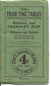
Ephemera - Timetable/s, Osboldstone & Co Pty Ltd and Printers and Publishers Melbourne, "OSBA Tram Time Tables with Railway and Tramway Map, of Melbourne and Suburbs", 1920's
Yields information about the tram timetables applicable to Melbourne's trams, including cable and electric and demonstrates the spread of Melbourne's public transport system in the early 1920's.Forty Eight page printed book contained with oversize green heavy paper covers centre stapled with a coloured map glued into the rear cover of the book titled "OSBA Tram Time Tables with Railway and Tramway Map, of Melbourne and Suburbs". Published c1920 - shows Footscray system, Victoria St Flemington link, does not show Puckle St. Timetables details Fares, first and last cars for cable and electric lines, sections and other details of the various lines. Note page 44 and 45 cannot be accessed, paper not cut correctly during the printing process - leave as is. Map prepared by Gawler and Drummond Architects, shows in colour the cable routes, electric tramways, authorised tramways and railway lines. Municipalities shown in different colours. Map folded into 12 sections. Published by Osboldstone & Co Pty Ltd, Printers and Publishers, Temple Court Place, Melbourne. Price 6d. Full scan of document added as a pdf file 5/6/2019. map, timetables, melbourne, cable trams -
 Melbourne Tram Museum
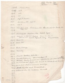
Document - Research Notes, H. S. McComb, Timeline of tramway development Melbourne, mid 1930's
... Maps ...Quarto plan sheet with hand written notes for the development of the drawings referred to in Reg Item 2153 - from 1906 to 1929, years 1930 and 1935 not completed. In the top right hand corner has the colour code to be used.trams, tramways, times, cable trams, railways, tramways, melbourne, maps -
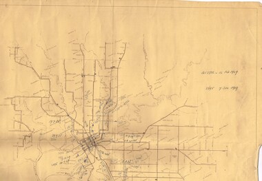 Melbourne Tram Museum
Drawing, Melbourne & Metropolitan Tramways Board (MMTB), MMTB Cable Tramway System, 1950's
... Maps ...Set of two drawings used by Mr McComb in his work to identify the various tramways, cable tram closure dates and authorisation's for the consolidation and revision of the 1958 MMTB Act. Based on MMTB Drawing P11819, titled "MMTB Tramway System", signed by Mr. Eakins in March 1952. .1 - sub-titled - "MMTB Cable Tramway System" with hand written dates of closure alongside the various cable tram lines and references to Acts. .2 - sub-titled - "MMTB Electric Tramway System" with hand written notes and references to Acts or Orders in Council and dates. Has the various numbers alongside each line that was used in the 1958 Act Schedules.have a date stamp of "3 July 1950" on rear.trams, tramways, cable trams, maps, closure, authority, acts of parliament, order in council -
 Melbourne Tram Museum
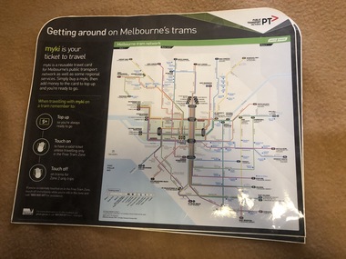
Map, Orajet, "Melbourne tram network", "Getting around on Melbourne's trams", Jan. 2015
... Maps ...Large plastic sheet, with an adhesive back and cover protective sheet - titled "Melbourne tram network" and "Getting around on Melbourne's trams" with PTV, Metro, Yarra Trams logos, shows fare zones, ticketing, free tram zone and information about Myki and how to use it.. Published 2015. Printed by Orajet, digital printing media. Has rounded corners along the top edge and square corners in both bottom corners. Two copies held.On rear in felt pen "Camira Orange Fine"trams, tramways, yarra trams, ptv, maps, free tram, melbourne, myki -
 Melbourne Tram Museum
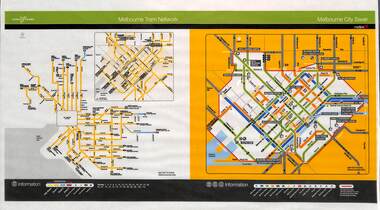
Poster, Yarra Trams, "Melbourne Tram Network", Nov. 2005
... Maps ...Full colour poster printed, A3 size, on laminated sheet - titled "Melbourne Tram Network. Shows a diagrammatic layout of the Melbourne tram system, shows zones (2 zones), CBD, tram terminuses including the City Saver boundary. Has the Yarra Trams and Metlink logos. Dated Effective November 2005trams, tramways, yarra trams, metlink, maps, metcard, tickets, city section -
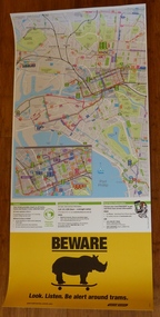 Melbourne Tram Museum
Poster, Yarra Trams, CBD and inner city tram routes, January 2012
... Maps ...Full colour poster printed on a vinyl plasticized based sheet showing all the public transport routes to the north and south of the CBD, includes major landmarks. Has information on where to buy tickets, customer information and tram tracker. At the base has a Beware Rhino's image. Has the Melway image as well. Dated Effective - January 2012.trams, tramways, yarra trams, maps, ptv, melbourne, public transport, rhinos -
Federation University Historical Collection
Booklet, Ballarat School of Mines Botanical Gardens Conservation/Restoration Management Plan
A Conservation/Restoration Management Plan for the Ballarat School of Mines Botanical Gardens. The report includes a planting timeline of the plants included in the gardens from 1850. Historical plans and maps are detailed from 1857 up to the site assessment in 2008.Printed report stapled at top left corner.Lisa Palmer written at top right corner in pencil.smb, school of mines ballarat, ballarat school of mines, botanical gardens, smb botanical gardens, conservation, restoration, ballarat school of mines garden, von mueller garden, ferdinand von mueller, botany, living collections, horticulture, gardens -
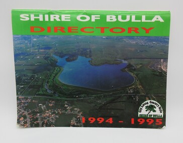 Hume City Civic Collection
Directory, Shire of Bulla Directory, 1994 - 1995
The Directory was published by the former Shire of Bulla in 1994 - 1995 and was issued to residentsa living withing the Shire. It features details of public services which were available within the area at the time as well as maps of the settlements and some private advewrtisements.A 20 page booklet with an aerial photograph of the Greenvale Dam and surrounding area on the front cover. A green strip is along the spine of the booklet with the words 'Shire of Bulla' printed in white and 'Directory' printed in red. '1994 - 1995' is printed in red across the bottom of the front cover and the Shire of Bulla - 'City Living . Country Style' logo is in the bottom RH corner. The back cover features an advertisement for the Roxburgh housing development.shire of bulla, directory, sunbury, bulla, attwood hill, craigieburn, george evans collection -
Moorabbin Air Museum
Map - South East Pacific Silk Maps
Historical Details: . Description: 4 Silk Survival Maps RAAF Issue (envelope) Survival Kit Documentation (envelope) AAP Date: Author: RAAF Amended to AL Publisher: RAAF Pages: Binding: Content/Keywords:. Level of Importance: -
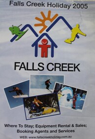 Falls Creek Historical Society
Booklet - Falls Creek Holiday 2005
Part of an annual marketing campaign, this booklet was designed to provide information for planning a holiday at Falls Creek for the winter of 2005. It includes details about activities, facilities and accommodation in the Village as well as maps and contact information to make necessary bookings.This item is important as it documents seasonal activities at Falls Creek Alpine Resort An A4 sized marketing booklet, including images and advertising information printed in colour and black and white.falls creek marketing, falls creek 2005, falls creek accommodation -
![Work on paper - Newsletter, North East Link & Hurstbridge Railway Line: Community Update [Sept. 2020], 2020_09](/media/collectors/4f729f5697f83e03086015b8/items/6014eb092bef110c704f0fb5/item-media/6014eb9a2bef110c704f1691/item-fit-380x285.jpg) Greensborough Historical Society
Greensborough Historical SocietyWork on paper - Newsletter, North East Link & Hurstbridge Railway Line: Community Update [Sept. 2020], 2020_09
Banyule City Council comments on the North East Link and Hurstbridge Railway Line projects. This newsletter is to keep the community informed of developments and opportunities for consultation. Includes a sketch map of Watsonia from Grimshaw Street to Lower Plenty Road.4 page leaflet, colour text and images.north east link, hurstbridge rail line, banyule city council, watsonia -
Melbourne Tram Museum
Document - La Trobe St, Public Transport Victoria (PTV), "Tram stop upgrades, relocations and removals", July 2024
Digital document from Public Transport Victoria (PTV) about the installation of platform stops in La Trobe St including the removal of existing stops. Has a map and images of the works that were undertaken during July and August 2024.Demonstrates a PTV information document regarding the installation of Platform stops in La Trobe St.Digital document - 5 pagestramways, platform stops, consultation, la trobe st, tram tracks -
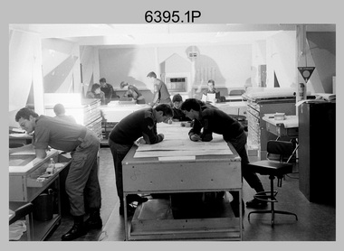 Bendigo Military Museum
Photograph - Army Survey Regiment – Map Production, Fortuna, Bendigo, 1986
These 17 photographs of the Army Survey Regiment’s map production and facilities were taken at Fortuna Villa, Bendigo, April 1986. Photos .1P to .3P were taken in Cartographic Squadron’s Correcting Section in the Attic. located on the top floor of Fortuna Photos .4P to .5P were taken in Cartographic Squadron’s Proving Section, located in the Ballroom also on the top floor facing the lake. The technicians were probably involved in a rapid response map production, as they all were wearing field uniforms. As ‘Regiment Overcrowding’ is annotated on the plastic sleeve holding the negatives, it seems the photos were taken when the unit was at its capacity to demonstrate the lack of suitable work areas. The Army Survey Regiment’s Duty Room, RAP and Carpark appearing in Photo .10P was probably taken from the top steps near the SGT’s accommodation block. Two of the photos in this set are also published in item 6096.5P.This is a set of 17 photograph of Map Production and car park was taken at the Army Survey Regiment, Fortuna, Bendigo, in April 1986. The black & white photographs are on 35mm negative film and are part of the Army Survey Regiment’s Collection. The photographs were scanned at 96 dpi. .1) - Photo, black & white, 1986. Correcting Section, Attic: L to R: CPL Andy Lucas, SPR Chris Gordon, unidentified, SPR Jan (Crighton) Minchin, CPL Robin Marshall, CPL Frank Downie, SPR Gayle Humphrey, unidentified (x2), Jason Wells at rear. .2) - Photo, black & white, 1986. Correcting Section, Attic: L to R: CPL Andy Lucas, SPR Chris Gordon, unidentified, SPR Jan (Crighton) Minchin, CPL Robin Marshall, CPL Frank Downie, SPR Gayle Humphrey, unidentified, Jason Wells, unidentified. .3) - Photo, black & white, 1986. Correcting Section, Attic: L to R: CPL Andy Lucas, CPL Robin Marshall, SPR Chris Gordon, unidentified, CPL Frank Downie, SPR Gayle Humphrey, unidentified, SPR Jan (Crighton) Minchin at rear., Jason Wells on phone. .4) & .5) - Photo, black & white, 1986. Proving Section, Ballroom: On left front to back: SGT Alan Staley, SGT Roger Rees, SGT Greg Anderson. On right front to back: SGT Denis McCarthy, SGT Tim Allanson, SSGT Adrian ‘Charlie’ Creedy. .6) - Photo, black & white, 1986. Records & Proofing buildings. .7) - Photo, black & white, 1986. Technical Services temporary buildings. .8) - Photo, black & white, 1986. Q-store and transport buildings. .9) - Photo, black & white, 1986. Technical Services temporary buildings in front of transport compound. .10) - Photo, black & white, 1986. Army Survey Regiment Duty Room, RAP and Carpark at Fortuna. .11) - Photo, black & white, 1986. Records & Proofing buildings. .12) - Photo, black & white, 1986. Other Ranks (OR’s) car park and barracks with kitchen in background. .13) - Photo, black & white, 1986. Other Ranks kitchen, parade ground and SGT’s/Officers barracks in background. .14) - Photo, black & white, 1986. Fortuna Villa taken from the steps near the SGT’s accommodation block. .15) - Photo, black & white, 1986. Fortuna Villa taken from the steps near the OR’s s accommodation block. .16) - Photo, black & white, 1986. Fortuna Villa taken from the roadway near the OR’s accommodation block. .17) - Photo, black & white, 1986. 20’ x 30’ Army tents set up on the basketball court..1P to .17P – ‘Regiment Overcrowding’ and the date are annotated on the plastic sleeve.royal australian survey corps, rasvy, army survey regiment, army svy regt, fortuna, asr