Showing 10549 items matching "sectioning"
-
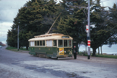 Ballarat Tramway Museum
Slide - 35mm slide/s, Travis Jeffrey, c1960
Agfa plastic mount (blue base, white cover) with a photo of No. 25 at Haddon St. with conductor standing at the back of the tram. Note terminal arrangements on the pole, tram stop sign, section sign, timetable board and painted pole stop sign (compulsory stop). Tram has a Mutual Homes dash panel advertisement on rear panel. Slide rescanned at 3200 dpi 24-10-2020, jpg replaced, tiff file retained. This file was scanned in 2003 and may show colour changes."BAS 5" in penciltramways, trams, wendouree parade, haddon st, tram 25 -
 Ballarat Tramway Museum
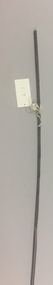
Functional Object - Trolley Wire Sample
Sample of trolley wire taken from overhead (South Trolley) at ear 10, which has been heavily distorted, with metal flow under ear, and abrasion marks possibly due to trolley pole "bounce". Grooving of wire varies with position of ear etc. Shows where 6 screw ear was located. Has cut marks at either end. See Reg. item 514 for details of wire size. See sketch for cross-sections and colours on original worksheet. Images added 3-12-2016ballarat, overhead, fittings, trolley wire -
 Ballarat Tramway Museum
Photograph - Black & White Photograph/s, The Courier Ballarat, 4/4/1960?
Yields information about the appearance of the tramway and other vehicular traffic in Ballarat in 1060 and was used to illustrate a proposal to rename the street.Black and White photograph of Ballarat No. 38 at the Eastern end of Sturt St West, following proposal to name that section the "Royal Mile". Photo published by The Courier 5/4/1960. Has the outbound tram standing while the front door is open with the driver looking back. Note the lack of motor vehicles (cars) in the street. Collected by Alan Bradley from the Ballarat Courier early 1980's. See Excel file "Record of Ballarat Courier Photos SEC era" (Archive Documents) for source of details.On rear stamped "Copyright, The Ballarat Courier Proprietary Limited." and "91 ARPT" in ink.tramways, trams, sturt st west, royal mile, tram 38 -
 Ballarat Tramway Museum
Document - Report, State Electricity Commission of Victoria (SECV), "Bendigo Tramways Track", 1960's
Yields historical notes about the method of track construction in Bendigo, the poor condition of the rails at the time of the report and the need to do work at Charing Cross.Typed foolscap sheet note or report titled "Bendigo Tramways - Tracks". Gives notes on the track construction methods of ESCo and reconstruction by the SEC. In the section titled 'Present Condition of Tracks". Note says need to obtain photographs and comments as for Ballarat. Also mentions that the CRB is anxious to re-deck the bridge running under Charing Cross - written date? Probably written for a report into the tramways by the SEC as part of a recommendation to close them. Appears to have been written in Ballarat, no mention of Geelong, so assume sometime in the 1960's.'BTPS 410" in top right hand corner.trams, tramways, bendigo, sec, esco, history, track, charing cross -
 Ballarat Tramway Museum
Functional object - Destination Roll, NSW Department of Road Transport and tramways, "Newcastle"
Destination roll use din a Newcastle tram - on linen, black background with various colours and white letters. Each destination 10" high. 6 joins in roll, each approx. 800 to 900 long section. Letters in caps. Destinations shown are: West Wal'send Wallsend and Platsburg New Lambton Lambton Broadmeadow Adamstown Waratah Merewether B'H (Beach) Newcastle Tighe's Hill Mayfield Glebe Boreas Road Special Depot Sport Grd Show Grd Racecourse Speedway Telford St Hamilton Depottram, trams, newcastle, destination roll -
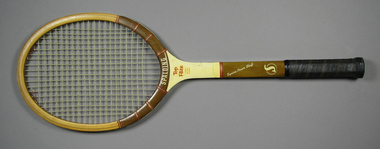
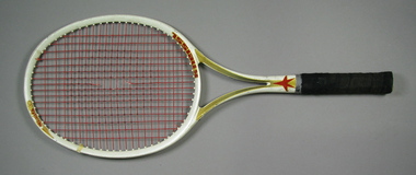 Tennis Australia
Racquet, Circa 1985
A Kniess White Star 'Aero 30' tennis racquet with open throat, plastic butt cap and handle wrapped with suede leather. Manufacturer's name on right side of throat on obverse and model name on left side of crown and on side of left throat pillar. Manufacturer's red star logo features on lower section of throat and on butt cap. Piece of cloth tape wrapped around frame near crown. Materials: Adhesive tape, Leather, Ink, Vinyl, Graphite, Kevlar, Plastic, Cloth tapetennis -
 Tennis Australia
Racquet, Circa 1955
A Spalding Top-Flite model tennis racquet, featuring whipping around shoulders and shaft, and wood grain finish on shaft & bottom section of head. Has leather wrapped handle and plastic butt cap. Manufacturer name features across base of head. Model name features across throat. On shaft is printed: 'SYNCHRO-POWER SHAFT'. Wreathed 'S' symbole features on lower shaft and on butt cap. Materials: Wood, Metal, Lacquer, Glue, Leather, Vinyl, Ink, String, Plastic, Adhesive tape, Painttennis -
 Kew Historical Society Inc
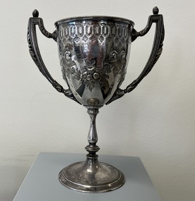
Award - Kew High School trophy, 1880
F.G.Barnard, writing in 1910, recorded that Ernest Ingle opened a boys' school in a private house in Cotham Road, Kew, in 1872. The school was later moved to larger premises in Charles Street, where suitable school rooms were added. Ingle's career was cut short by a fatal attack of typhoid fever in 1875. The school then passed into the hands of Mr. J. Henning Thompson. Under Thompson's management the school speedily became a strong rival to the neighbouring Hawthorn Grammar School. Barnard also lists in his Jubilee History of Kew, that Dr N.C. Vance [winner of the trophy for the 440 yards running event] was a notable alumnus of Kew High School. It is assumed that N.C. Vance was the son of Rev G.O. Vance who was appointed vicar of Holy Trinity Church, Kew, in 1870. This is a tangible memento of the first Kew High School, awarded to a pupil eight years after the school's establishment. The trophy is historically interesting as it was presented to N.C. Vance by Ann Bon, a notable Kew resident and a supporter of Indigenous People in Victoria, particularly William Barak and his family.Silver plated trophy in the form of a cup on a pedestal with two arms, each surmounted with pine cones. The trophy has a range of design features including convex and concave decorated surfaces created by repoussé (i.e.hammering). Specific decorative aspects include scrolling at the top of the cup and floral sprays at front and the rear of the trophy. There is a single inscription identifying the school, the event, the winner and the identity of the person presenting the trophy. The metal used in the cup section of the trophy is heavier and thicker than that used in the rest of the trophy.There are no compositional or maker marks on the trophy.Inscribed: "Kew High School / Old Boys Cup / Presented by / Mrs John Bon / Won by / N Vance 1880"dr n vance, kew high school -- kew (vic.), private schools -- kew (vic.), sports trophies -- kew (vic.), n.c. vance -
 Kew Historical Society Inc
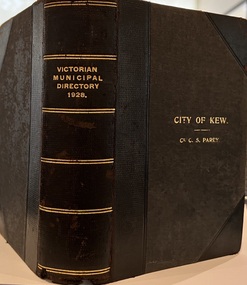
Journal, Arnall & Jackson: Printers & Stationers, Victorian Municipal Directory and Gazetteer : Also Commonwealth Guide and the Water Supply Record for 1928
The Victorian Municipal Directory provided annual details, and later bi-annual details, of all councils. Published by Arnall & Jackson (Printers and Stationers), copies were published in 'cloth' for sixteen shillings and 'half roan' for eighteen shillings. This copy was owned by Cr C.S.Parry. Elected to the Kew City Council as a representative of North Ward, Cr Parry was elevated to the position of Mayor in 1931. It, together with five other editions, was presented to the Kew Historical Society in 1987 by his grandson.Bound copy of the Victorian Municipal Directory and Gazetteer: Also Commonwealth Guide and the Water Supply Record for 1928. The volume contains 846 pages and includes sections on: - Comparative table – Municipal Returns for Twenty-one Years. - Index to Townships, Parishes and Railway Stations. - Changes and appointments. - Commonwealth of Australia (Constitution, Parliament, Departments and Officers). - State of Victoria (Parliament, Departments and Officers / Boards, Institutions, Trusts and Loans). - Municipalities in Victoria (Cities and Towns, Boroughs, Shires). - Water Supply (State Rivers and Water Supply Commission).non-fictionThe Victorian Municipal Directory provided annual details, and later bi-annual details, of all councils. Published by Arnall & Jackson (Printers and Stationers), copies were published in 'cloth' for sixteen shillings and 'half roan' for eighteen shillings. This copy was owned by Cr C.S.Parry. Elected to the Kew City Council as a representative of North Ward, Cr Parry was elevated to the position of Mayor in 1931. It, together with five other editions, was presented to the Kew Historical Society in 1987 by his grandson. victoria -- registers -- periodicals., victoria -- directories., water-supply -- victoria -- directories., municipal government -- victoria -- periodicals., cities and towns -- victoria -- directories. -
 Kew Historical Society Inc
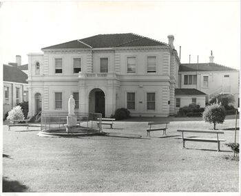
Photograph, Madford, Wellington Street, circa 1965, c. 1965
This work forms part of the collection assembled by the historian Dorothy Rogers, that was donated to the Kew Historical Society by her son John Rogers in 2015. The manuscripts, photographs, maps, and documents were sourced by her from both family and local collections or produced as references for her print publications. Many were directly used by Rogers in writing ‘Lovely Old Homes of Kew’ (1961) and 'A History of Kew' (1973), or the numerous articles on local history that she produced for suburban newspapers. Most of the photographs in the collection include detailed annotations in her hand. The Rogers Collection provides a comprehensive insight into the working habits of a historian in the 1960s and 1970s. Together it forms the largest privately-donated collection within the archives of the Kew Historical Society.‘Elm Lodge’ had a frontage to Wellington Street and extended to Cotham Road. It was renamed ‘Madford’ in 1874, after its purchase by the pastoralist Arthur Septimus King, the grandson of Philip Gidley King, third Governor of New South Wales. The Alexandra Gardens were developed on the northern section of Madford after the sale of the land to the Borough of Kew in 1905. King’s house, and the remaining garden, was sold to the Catholic Church in 1920, and subsequently developed into ‘St Anthony’s Home for Babies’ in 1922. The organisation relocated to Footscray in 1975, and the building demolished."Madford (formerly Elm Lodge) in Wellington Street Kew during the period when it was St. Anthony's Home for babies (now demolished). From the 1860s it had been the home of the King family. Harold Septimus King was one of the notable residents of Kew."madford, elm lodge, wellington street (kew), dorothy rogers -
 Kew Historical Society Inc
Map, MMBW, MMBW Plan No.39 Kew & Heidelberg, 1900-1910
The Melbourne and Metropolitan Board of Works (MMBW) was established by an act of the Victorian Parliament in 1890 to prepare for and to implement a sewerage and water reticulation system across what was then inner Melbourne, its surrounding and middle distance suburbs, including Kew. The MMBW was disbanded in 1991.The map collection of the Kew Historical Society has at its core the historic maps assembled and originally stored in the City Engineer's Department of the City of Kew. These include maps in a number of scales. The vast majority of maps were produced by the MMBW in the first two decades of the twentieth century, and are solid working maps, backed by linen for durability. These maps are historically significant to Kew, the City of Boroondara and to the history of the development of state utilities in Victoria. A number of the Kew maps have additional details added by former municipal officers, including the levels reached by various floods. As these were working documents, information was added to them long after the period of their initial production and distribution.Early map of part of the Borough of Kew, created in the first decade of the twentieth century, at a scale 160 ft to 1 inch. The map covers what was then the north western section of Kew, bordered on its north by Wills Street and the Kew Lunatic Asylum, in the west by the River Yarra [and the later added Yarra Boulevard] , by Princess Street in the East and Holroyd Street in the south. The map shows the extent of urban development by that time, prominent institutions and the outlines of built structures in the municipality. Contour lines were added in ink to the map at a later stage.MELBOURNE AND METROPOLITAN BOARD OF WORKS / PLAN NO. 39 / KEW & HEIDELBERGmelbourne & metropolitan board of works, mmbw maps, mmbw plans, borough of kew, cartography -
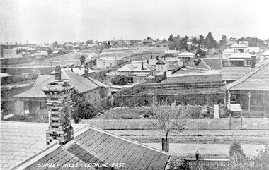 Surrey Hills Historical Society Collection
Photograph, Surrey Hills - Looking East from Essex Road, circa 1900, c1900
Date is approximate. Two original post cards of this image - "Surrey Hills - looking East" - were donated by Stephen Wyatt on 10 March 2012. One is blank; the other has been sent to Mrs A Wyatt, C/O Mrs E Young, 'Grand View', Warburton from daughter Nellie from 'The Quantocks', Surrey Hills - postmarked 10 Dec 1906. There is also a reproduction of this image in a framed collage of Surrey Hills photos.This is the earliest known image of the Surrey Gardens. The layout was originally designed by William Guilfoyle, who also designed Melbourne’s Royal Botanic Gardens.Black and white photo taken from an early postcard. Taken from the roof of a house in Essex Road, it shows the development of housing between Essex and Union Roads and includes the section of land fenced off for the Surrey Gardens with paths roughly laid out, one existing tree but no tree planting. The houses depicted are largely Edwardian timber buildings with corrugated rooves. There are still some vacant blocks. Kirkland on Union Road can be seen in the distance, as can some of the shops along Canterbury Road.Lower LHS within original image: " Surrey Hills - Looking East"; on the rear "No 17" in black pen in top LH corner.edwardian style, residential development, kirkland, essex road, suffolk road, norfolk road, surrey gardens, post card -
Tarnagulla History Archive
Registration of Death form, 1872
A large lot of papers, including this and many other birth and death registration forms, were apparently found in the ceiling cavity of the Sandy Creek/Tarnagulla Post and Telegraph Office in the later 20th Century, during building works. Donald Clark Collection. Registration of Death form Name of deceased: Signor Piori Rank or Occupation: Miner Age: section missing Cause of Death: Deceased of Hart (as spelled), noted elsewhere on form 'Inquest 18th Sept' and 'Of valvular disease of the heart'. Duration of illness: Sudden death Date of Death: 17th September 1872 Place of Death: Jones Creek Place of burial: Jones Creek Father's name: not known Mother's name: not known Spouse: not known Deceased place of birth: Switzerland Lived in the Colony: 18 years -
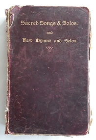 Mont De Lancey
Book, Ira D. Sankey, Sacred Songs & Solos: and New Hymns and Solos, Late 1800's early 1900's
The 750 pieces of Sacred Songs and Solos at the front of the collection were compiled and sung by Ira D. Sankey who was an American gospel singer and composer, known for his involvement in a series of religious campaigns in America and Britain during the closing decades of the 19th century. His style influenced church services and evangelical campaigns for generations and the hymns he wrote or popularised continued to be sung well into the 21st century. A collection of 138 pieces of New hymns and Solos compiled by Ira D. Sankey and written by various authors is at the back of the book.A thick burgundy hardcover book with the title printed in gold lettering at the top of the front cover - Sacred Songs & Solos: and New Hymns and Solos. It was compiled and sung by Ira D. Sankey. The spine has the title in gold lettering at the top. The front cover is detached from the spine. The 750 pieces of music and words were compiled and sung by Ira D. Sankey. There is a an Index to Titles, Contents, Index to Subjects and a Metrical Index at the back of the first section. p. At the back of the New Hymns and Solos there is an Index for the 138 hymns and solos. non-fictionThe 750 pieces of Sacred Songs and Solos at the front of the collection were compiled and sung by Ira D. Sankey who was an American gospel singer and composer, known for his involvement in a series of religious campaigns in America and Britain during the closing decades of the 19th century. His style influenced church services and evangelical campaigns for generations and the hymns he wrote or popularised continued to be sung well into the 21st century. A collection of 138 pieces of New hymns and Solos compiled by Ira D. Sankey and written by various authors is at the back of the book.hymns, religious books, religious songs -
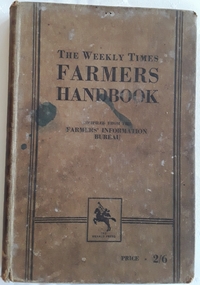 Mont De Lancey
Book, Milshinock, The Weekly Times Farmers' Handbook, 1933
A handbook for farmers compiled from articles from practical information from the Rural Section of the Weekly Times in Australia. It has informed generations of farmers on the way of the land, with useful tips and invaluable advice. Few farms would have been without a well-thumbed copy.A brown hardcover book with the title printed in black text, The Weekly Times Farmer's Handbook. Compiled from the Farmers' Information Bureau with the publisher The Herald Press in a square underneath. Price - 2/6 at the bottom. Three black lines decorate both sides and across the Publisher section. Ink stains on the front. The spine has the faded title written. An index is at the back, along with advertising for farming products and equipment. 240p. Stains and foxing on the edges of the pages are visible. Some damage to the spine top and bottom.non-fictionA handbook for farmers compiled from articles from practical information from the Rural Section of the Weekly Times in Australia. It has informed generations of farmers on the way of the land, with useful tips and invaluable advice. Few farms would have been without a well-thumbed copy.farming australia, farming, the weekly times newspaper -
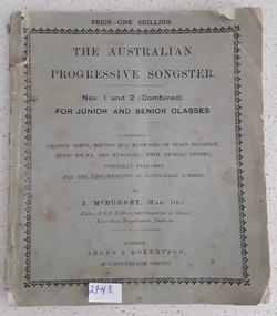 Mont De Lancey
Book, Angus & Robertson, The Australian Progressive Songster, Unknown
A progressive musical songster with theory and exercises.A small grey paperback textbook titled The Australian Progressive Songster. Nos.1 and 2 (Combined) for Junior and Senior Classes. Containing Graded Songs, Rounds and Exercises in Staff Notation, Tonic Sol Fa, and Numerals, with Musical Theory, Specially Prepared for the Requirements of Australian Schools, by S. McBurney, Mus.Doc. Fellow T.S.F. College, late Inspector of Music, Education Department, Victoria. Price - 1 Shilling. As it is quite damaged from use there is no back cover and Page 48 of the second section, Exercises, is torn badly. No publishing date. non-fictionA progressive musical songster with theory and exercises.music documents, music books, textbooks -
City of Kingston
Photograph - Colour, c. 1993
Patterson Lakes is a suburb in the City of Kingston that is built one kilometre upstream of the mouth of the Patterson River. The area is bordered by the Patterson River and Eel Race Drain which enters the Kananook Creek. The suburb consists predominantly of newer housing developments and the tidal canal system of the development joins Port Phillip Bay.Patterson Lakes and the Kananook Creek were previously part of the extensive Carrum Carrum Swamp. The area was once a source of fish and eels for the Mayone-Bulluk clan of the Bunurong people. Over time the area was drained and in 1973 investigations commenced into the development of a unique residential area that would be built adjacent to canals and waterways. It was originally proposed to be known as "Gladesville". The development would give the suburb's homeowners access to Port Phillip Bay "from their back door". Circa 1974, the area was rezoned from rural to residential and named Patterson Lakes. Development has been continuous since the 1970s with construction of residential housing, schools, shopping centres, marinas, a hotel and library.Laminated colour aerial photograph of the Carrum and Patterson Lakes region within City of Kingston. This 1993 image includes Patterson River Secondary College, Roy Dore Reserve, Kananook Creek and Nepean Highway. The railway line can be seen as it veers inland from Eel Race Road, Seaford. The section of Palm Beach Drive, Curlew Point Drive, Snapper Point Drive, Clipper Island and Myola Street in Patterson Lakes appears to be a recent development with many spare blocks and new houses under construction.patterson lakes, seaford, kananook creek, carrum carrum swamp, canals and waterways -
City of Kingston
Photograph - Colour, 29 January 1993
Bonbeach, Carrum and Patterson Lakes are suburbs in the City of Kingston. Bonbeach and Carrum were holiday destinations in early 20th century and over time the housing has converted to permanent residential structures. In Patterson Lakes, the area consists predominantly of newer housing developments and the tidal canal system which is accessible to many dwellings joins Port Phillip Bay.Bonbeach, Carrum and Patterson Lakes were previously part of the extensive Carrum Carrum Swamp. The area was once a source of fish and eels for the Mayone-Bulluk clan of the Bunurong people. Over time the area was drained and this allowed farming at Carrum and Bonbeach, although the area was prone to flooding. In the early 1920s and 30s the land was converted to residential dwellings. In 1973 investigations commenced nearby to Bonbeach and Carrum into the development of a unique residential area comprising canals and waterways. It was originally proposed to be known as "Gladesville". Circa 1974, the area was rezoned from rural to residential and named Patterson Lakes. Development has been continuous since the 1970s with staged construction of the waterways, residential housing, and supporting infrastructure and facilities.Laminated colour aerial photograph of the Bonbeach, Carrum and Patterson Lakes region within City of Kingston. This 1993 image includes Bonbeach High School prior to demolition, Bonbeach Primary School and Patterson River Golf Club. Sections of Patterson Lakes are not yet developed, including Rhode and Staten Islands. Long Island Point appears to be a recent development with many spare blocks and new houses under construction. The Patterson River marina is prominent and the river mouth as it meets Port Phillip Bay. The Carrum railway station is visible.Black type on white adhesive sticker: No. 6661 Black type on white adhesive sticker: 26E/6661, 29/1/93, 4.25 pm Black type on white adhesive sticker 29-1-93 Yellow circular adhesive stickerbonbeach, carrum, patterson lakes, patterson river, carrum carrum swamp, canals and waterways -
City of Kingston
Photograph - Black and white, 17 January 1951
Moorabbin, Cheltenham and Highett are suburbs in the City of Kingston with a diverse mix of development and zoning. This 1954 image shows the market gardens, farms and paddocks of the Moorabbin and Cheltenham area. which have gradually been sub-divided into The Highett Gas Works is visible and Cheltenham Park and Victoria Golf Club.The suburbs of Cheltenham and Moorabbin were originally developed with extensive market gardens. Over time the district has been transformed with the farms and paddocks replaced by housing, factories and shopping centres. The Highett Gas Works on the Nepean Highway was a significant feature of the landscape and has now been demolished. and the site has undergone remediation.Aerial photograph of Cheltenham, Moorabbin and Highett within the City of Kingston. The area depicted in this 1951 aerial view includes Wickham Road, Highett (bottom right), Keys Road, Moorabbin (bottom left), Centre Dandenong Road Cheltenham (top left), Park Road, Cheltenham (top right), Nepean Highway (left section), Graham Road and Middleton Street, Highett (bottom right). Cheltenham Park and Victoria Golf Club are visible. Nepean Highway and the Frankston railway line run centrally through the image.White type: 1416-37 538 RUN239 LENS 5312" MELBOURNE METROPOLITAN 12150 17-1-51 ↆ M539 Black pencil: N [arrow]cheltenham, highett, highett gas works, market gardens -
 Bendigo Historical Society Inc.
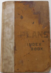
Document - LANDS OFFICE, - INDEX TO CROWN LANDS SURVEYED AND SOLD IN THE DISTRICT OF SANDHURST
Document: Buff hard cover book, with fawn coloured binding on spine (later addition to mend spine?) On front cover drawn in black pen ' PLANS' and 'Index Book' On spine written in black ink ' plans index book'. Contains index of parishes in front of journal with 470 pages indexed to parishes. Double page entries: LH side page: town, suburban or country lands, total lands surveyed. Date of survey. RH page: allotment, section, particulars, no. page. Entries are not dated.Lands Officeland sales, lands office, land surveyed , land sold, bendigo, sandhurst -
 Bendigo Military Museum
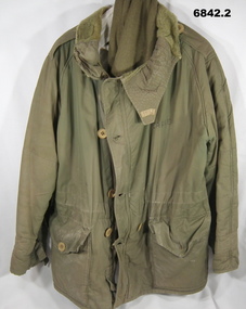
Uniform - PARKA AND SCARF, unknown
This is a military, very cold environment jacket. Suspect Korean War vintage, possibly British or Aust. made. 1. This is a green jacket, 100% lined with fur. It has a raised fur lined neck. It has two pockets on lower front. The pockets have an inner neck (5 cms). Pockets held shut with buttons. The front is held shut with a metal zip and big buttons. The buttons are 28mm diameter, light brown. The wrists have draw straps to seal out cold. Ref: The lining inside:- Rear section fully sewn in, in the two front panels, the bottom edges are not sewn in. 2. Scarf. Woollen, Khaki, thick. Written on front left jacket chest is name - “PEARSE”cold weather coat, korean war, passchendaele barracks trust -
 Bendigo Historical Society Inc.
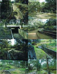
Photograph - COLIBAN MAIN CHANNEL, July,2009
Photograph - colour. All photographs are of the Coliban Main Channel. Photo's 1,2,3,4 + 5 = were taken from South Mandurang Road, Spring Road end. Photo's 6,7,8,9,10,11,12 + 13 = were taken top of dirt road section of Springs Road. Photo's 14 + 15 = Taken between Sedgwick and North Harcourt, used to be called 'Prestonvale'. Photo No.14 is called Wirths Tunnel, 633 metres in length. Three more sheets of photo's of the Coliban Main Channel, between Sedgwick and Harcourt North. If more info.Ray Smith and Phil Wilkin - Bendigo Historical Society.place, water, coliban race, coliban main channel. -
 Bendigo Historical Society Inc.
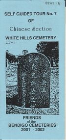
Document - BENDIGO CEMETERIES COLLECTION: SELF GUIDED TOUR NO.7 DOCUMENT
BHS CollectionBlue coloured document, trifold. Self Guided Tour No. 7 of Chinese Section, White Hills Cemetery, Friends of the Bendigo Cemeteries 2-001 - 2002. Theme 'A hundred years after Federation' Map with numbered grave sites, with descriptions e.g. Louey Ah Pon, passenger involved in a fatal car accident with a bus on High St., a market gardener of Golden Square. Chung Fook Jao, committed suicide in his hut on the New Chum Mine site where he had worked the tailing for many years.Friends of the Bendigo Cemeteries 2000bendigo, cemetery, white hills cemetery tour -
Clunes Museum
Ephemera - FIREMARKS
.1 Black plaque, raised teardrop with building, crown on top, red background with number .2 Black plaque, raised oval, showing castle and lion .3 Black plaque, rectangular, gold sun with face on blue, lion, a circular raised section with name below .4 Black rectangular plaque, spearhead shape raised, gold border, crown on top. Building depicted in spear head .5 Black plaque, circle shape raised, gold with lion and unicorn, sheild with lute/harp on top in centre.1 Royal Exchange .2 Norwich .3 Bath Sun .4 Royal Exchange .5 ABERDEEN ASSURANCE COMPANY, SCOTLAND 1825firemark, fire office, plaque -
 Bendigo Historical Society Inc.
Document - LANDS OFFICE: REPORTS OF LAND SALES BY AUCTION 1876 - 1891, 1876 - 1891
Document: green hard cover journal, buff spine and corners. Contains details of land sales by public auction Kerang, Swan Hill and Boort. m LH page ' Lot, County, Town or parish, section, allotment, sold, unsold, why not sold, upset price, sold per acre. RH page: value of improvements, name of purchaser, residence, deposit forfeited, total amount. On spine in gold lettering ' report of sales by auction' underneath 'land sales' in black. No. 6 on top of spine, letter K on base.Lands Officeland sales, kerang, swan hill, boort, sandhurst, lands office -
 Bendigo Historical Society Inc.
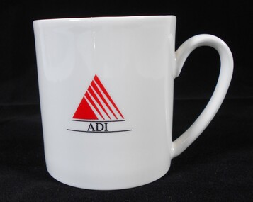
Ceramic - Australian Defence Industries (ADI) three ADI mugs
Australian Defence Industries (ADI) three ADI mugs. a) White mug with ADI (black lettering) and Red ADI "sail" emblem b) cream mug with black lettering "Australin Defence Industries Pty Ltd Bendigo (054) 40 4311 circles a green / cream triangular symbol. No maker's is identified. Some minor chips to rim and to interior. c) cream with thick blue upper section with blue extending half handle. ADI emblem with "Bendigo " written below plus "5s + 1". a) Aria, porcelain made in Australia by Australian fine china b) no maker's mark c) maker's mark on base - Bendigo Pottery est. 1858local history, adi history -
 Melbourne Tram Museum
Manual, Metlink, "Metlink Metropolitan Fares and Ticketing Manual", May. 2004
Document - 66 single sided sheets, of 66 sheets, A4, printed or copied titled "Metlink Metropolitan Fares and Ticketing Manual", dated May 2004, about the tickets available, fare concessions, passes and travel authorities, cartage of animals and various items, ticket prices, charges, refunds, replacement and general information for Metcards. Advises what is not include. Has a table of contents on page 1 and then for each section. Has been punched with three holes on the left hand side and on the right hand side for page 4 onwards.Has "S&B" in ink on top right hand corner.trams, tramways, metcard, metlink, tickets, metlink -
 Warrnambool and District Historical Society Inc.
Book - Family Bible, John Murphy Company, The Holy Bible Douay Version, 1899
This Bible and cover belonged to Ethel Ardlie, nee Ryan (1880-1967). In 1903 she married Arthur Stanley Ardlie of Warrnambool. Arthur Ardlie was the son of the prominent Warrnambool lawyer, William Ardlie and his wife Mary and the grandson of John and Mary Ardlie, pioneer settlers in Warrnambool. Ethel and Arthur Ardlie had three daughters, Olive (1905- 1912), Dorothy (1910-1993) and Agnes (1915-1993). They lived at Aroona, Princess Street, Warrnambool.These items are of great interest firstly because they are examples of the type of Bible and cover that families owned in the mid 20th century. Also they are mementoes of a prominent family in Warrnambool in the 20th century, with the Bible containing important information on this family. .1 This is a Bible with a black cover with gold lettering on the spine. The cover is stained. The pages contain the Old Testament (1086 pages), a Family Register section, the New Testament (306 pages) and some coloured maps. Amongst the pages are two pressed pansies and two loose sheets. .2 This is a brown tooled leather cover for the Bible with a brown silk lining and a brown cord attached to the top of the spine for use as a bookmark. The front cover has an embossed image of seven figures. The edges of the spine of the cover are torn. Ethel M. Ardlie (x2) Aroona, Warrnambool ardlie family, history of warrnambool -
University of Melbourne, Burnley Campus Archives
Plan, New School of Primary Agriculture & Horticulture Burnley Gardens, 1945
Photocopy of Plan of the Administration Building by the Chief Architect dated 26.9.45. Scale 1/8 inch - 1 foot. Photocopy reduced in size from original. (1) Ground Floor and First Floor Plans. (2) West Elevation, Longitudinal Section 'B-B' and East Front Elevation. (3) Flat Roof, Library and Herbarium. (4) Common Room and Assembly Hall. Originally in the Burnley Archives. Property and Service now have the original and gave the reduced size photocopy to the Archives. Hard to read now.burnley gardens, school of primary agriculture and horticulture -
 Bendigo Military Museum
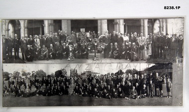
Photograph - ANZAC DAY PHOTOS BRSL, C. 1950 - 51
The photo in .2) cylinder is an original of the top photo in .1) in front of the Soldiers Memorial Institute. Even though it says 1951 this is not a certainty for both. It has not been taken out for proper photography due to its fragile state. There are a few that have been identified in both who were well known. Top photo. Standing 2nd from the left is Jack Swatton, next to him is George Lansell, further along standing at rear is a tall man Les Morey with black hair and greyish suit. Bottom photo. On the far right standing is Jack Swatton, in the front row sitting central is possibly George Lansell, two men to his right are looking at him, in the rear 8th from the left is Les Morey. There is one very tall man in the rear central which his identity is being checked. Refer also Cat No 8229P. .1) Photographs B & W panorama, two laminated together. The top photo shows a large group of men and some ladies lined up in front of the Soldiers memorial Institute Pall Mall Bendigo, there are 5 large wreaths and a big white Cross central. The bottom photo shows a larger group of men and 3 young lads on the "Upper Reserve" in Bendigo. .2) Shows a cardboard photo cylinder with address paper around with text showing a section the rolled photo out at one end of the cylinder.On .1) written over in black is hand written, "1951 ANZAC DAY", on .2) hand written, "G.B. ... 541 High S.....et Bendigo"brsl, smirsl, anzac day