Showing 22317 items
matching parks
-
 Eltham District Historical Society Inc
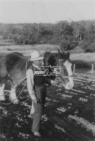
Photograph, Guildo Fabbro, Falkiner Street, Eltham with Clydesdale horse
Guildo Fabbro, Falkiner Street, Eltham with Clydesdale horse with harness in field. The site of the Fabbro farm (Diamond Creek side land) is now called Barrack Bushlands. It is doubtful that Fabbro's farm holding was ever called Barrak Park, This title is fairly recent after the Shire of Eltham purchased the land, including the last section in 1993/94. About this time the area on the west side of Falkiner Street was purchased by a private developer and developed as housing. The area in Bell Street opposite the Eltham High School was purchased by the State Government is recent years and is called Fabbro Fields. The Fabbro Family operated their farm in Bell Street, Eltham. 1 black and white photographfabbro's farm, guido fabbro, bell street, clydesdale horse -
 Eltham District Historical Society Inc
Photograph, 1934 Floods at Eltham
Published in the Diamond Creek Basin Study, 1980 and identified at Diamond Creek, locality not identified, 1934. The location is actually looking south across the Diamond Creek towards Falkiner Street, beside the Main Road bridge at Eltham South from what is now part of Wingrove Park opposite Antoinette Boulevard. The bridge railing is just visible to the left of image. The large leaning Manna Gum beside the bridge still stands in 2021 alongside the Diamond Creek trail. In 1934 extensive flooding of the Yarra River and Diamond Creek set new records for flood plain level (Eltham Chronology, EDHS)Black and white photographCopied by Hugh Fisher, Photographer, 6 York Street Eltham A1678B Floods- Eltham - 1934floods, yarra river, eltham, flooding, diamond creek, flood -
 Eltham District Historical Society Inc
Photograph, Eltham campers
Barbara Seidel of Eltham has provided a copy of a photo of a group known as the "Eltham Campers" which included some of her relatives. Jock Read and Garnie Burges remember this group from the 1920's. They used to camp on the old pound site at Eltham Lower Park. They met in North Fitzroy and every A.N.A. weekend they cam to Eltham to camp. They had big tents and set up a stage on backs of their wagons or lorries. A concert was held on the Sunday night for local people to attend. They had very good artists including a pianist, violinist, flautist and banjo player. - EDHS Newsletter No. 83, March 1992Colour photograph copy of original showing a camping group at Eltham known as the Eltham Camperscamps, campers, eltham, groups, eltham campers, eltham lower park, eltham pound, concert -
 Eltham District Historical Society Inc
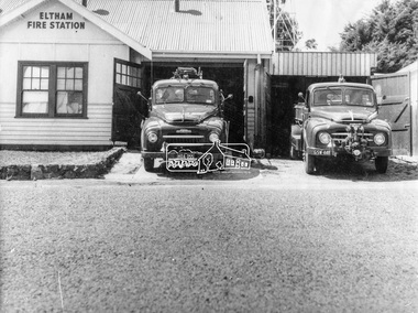
Photograph, George W. Bell, Eltham Fire Station, east side of Main Road, c.Jan 1964
The photograph was taken (and donated) by George W. Bell during the period of fire, c.1963-c.1964. The actual fire station was built c.1930 and was in use till c.1964 when a new fire station was built on the opposite side of Main Road. The building, originally situated just south of Arthur Street, on Main Road was ultimately relocated in 1970 to Research Park for use by the 1st Research Scout group. The site is now part of the current Coles supermarket and Eltham Village complex. The Fire Trucks are an Austin STU (small town unit) on the left and an Austin urban pumper on the right. This photo forms part of a collection of photographs gathered by the Shire of Eltham for their centenary project book,"Pioneers and Painters: 100 years of the Shire of Eltham" by Alan Marshall (1971). The collection of over 500 images is held in partnership between Eltham District Historical Society and Yarra Plenty Regional Library (Eltham Library) and is now formally known as 'The Shire of Eltham Pioneers Photograph Collection.' It is significant in being the first community sourced collection representing the places and people of the Shire's first one hundred years.Digital imageaustin stu fire truck, austin urban pumper, eltham, eltham fire brigade, fire station, fire truck, george w. bell, motor vehicles, shire of eltham pioneers photograph collection -
 Federation University Historical Collection
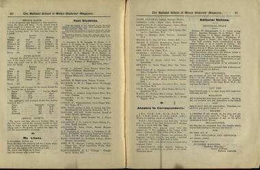
Magazine of 24 pages, Baxter & Stubbs, Print, Ballarat School of Mines, Student Magazine, Third Term, 1911, 1911
Table of Contents: Editorial, Inventions and inventors, The hydroplane launch "Maple Leaf III", Hints on examination, First aid, Some geographical features at Ballarat, The volumetric determination of potassium, Milk, The cannon, A scientific apologue, New inventions by Tesla, Coronation fair, First aid, Cinematography, Electrical chatter, Education and training of engineers, Mining notes, Engineering students midwinter excursion, Hints to S.M. B. yachtsmen, News and notes, The long and short of it, Abbreviated account of the geology of the Forbes-Parkes gold field, Excursion to Pyke's Creek Reservoir, A practical joke, Sports, Past students, Answers to correspondents, Editorial notes.table of contents: editorial, inventions and inventors, the hydroplane launch "maple leaf iii", hints on examination, first aid, some geographical features at ballarat, the volumetric determination of potassium, milk, the cannon, a scientific apologue, new inventions by tesla, coronation fair, first aid, cinematography, electrical chatter, education and training of engineers, mining notes, engineering students midwinter excursion, hints to s.m. b. yachtsmen, news and notes, the long and short of it, abbreviated account of the geology of the forbes-parkes gold field, excursion to pyke's creek reservoir, a practical joke, sports, past students, answers to correspondents, editorial notes., alumni: w. k. clifford, j. adam, wilfred avery, h. baxter, l. w. g. buchner, h. caulfield, a. cropper, e. b. crossley, w. currie, dave don, hilary dowling, chas fraser, a. d. galloway, w. geldard,t. e. copeland, l, j. coulter, j. dickinson, g. h. hall, godfrey s.hart, w. b. hirt, h. e. hawkesworth, oliver e. jager, carl janssen, w. t. lakeland, l. j. lambert, c. lund, r. i. moore, byron k. moore, f. a. moss, jack orr, douglas runting, w. t. sayer, l. seward, h. s. sheppard, c. e. sands, n. stuckey, r. vale, r. watts, reg williamson, w. baragwanath, c. c. corrie, r. g. walker, g. g. sams, r. a. j. roberts, r. blight, h. cornell, v. booth, miss l johnson. -
 City of Moorabbin Historical Society (Operating the Box Cottage Museum)
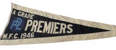
Flag - Federal District League A Grade Premiers Flag, Moorabbin Football Club, 1946
Moorabbin played initially in the Federal Football League also known as Football Federation Australia, making their debut in 1909 and competing until 1950. The club wore a black and white jumper like Collingwood. During this time the club won 12 premierships, including winning all six premierships staged over the nine years between 1940 and 1948 (the competition was in recess from 1942 until 1944). Moorabbin Football Club was also known as Moorabbin Park Football Club in the early years of its formation. In 1946 Moorabbin 18 goals 17 points (125) defeated Cheltenham 9 goals 17 points (71).Moorabbin Football Club was established 1909 and was very successful playing in the Federal Football League, Victorian Football Association. Premiers FlagA Grade - FDL - Premiers - M.F.C. 1946federal football league, moorabbin football club, premiership, moorabbin, australian rules football -
 City of Moorabbin Historical Society (Operating the Box Cottage Museum)
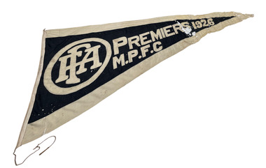
Flag - Federal Football Association Premiers Flag, Moorabbin Park Football Club (Moorabbin Football Club), 1926
Moorabbin played initially in the Federal Football League also known as Football Federation Australia, making their debut in 1909 and competing until 1950. The club wore a black and white jumper like Collingwood. During this time the club won 12 premierships, including winning all six premierships staged over the nine years between 1940 and 1948 (the competition was in recess from 1942 until 1944). Moorabbin Football Club was also known as Moorabbin Park Football Club in the early years of its formation. In 1926 – Moorabbin 13 goals 11 points (89) defeated Mordialloc 9 goals 17 points (71). One of the pioneer teams of the City of MoorabbinFlagfederal football league, moorabbin football club, premiership, moorabbin, australian rules football -
 Port Melbourne Historical & Preservation Society
Document (Item) - Collection of documents relating to the life of Norma Madeline Watters, 1930's - 1974
A collection of documents relating to the life of Norma Madeline WATTERS. These include 1935 & 1937 School certificates from Middle Park Central School; a cookery certificate from Mac Robertson Girl's High School; a certificate from the Victorian Baby Health Centres Association; a war savings certificate from The State Savings Bank of Victoria; a number of letters confirming her appointment to various clerical positions in the firms of Rootes, Austral Silk and Cotton Mills Pty Ltd, The Myer Emporium, W.E. Bassett & Associates, The Metropolitan Gas Company, Hardware Co. of Australia, Gill Glass and The Phosphate C-operative Company of Australia Ltd.education - primary schools, education - secondary schools, norma madeline watters, rootes/chrysler -
 Victorian Interpretive Projects Inc.
Photograph - Colour, Clare Gervasoni, Tower Hill, Victoria, 2013, 2013
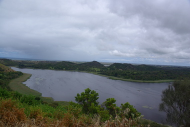
The Tower Hill Reserve is located inside a dormant volcano, and features a lake and wetlands. It became Victoria's first national park in 1892, but by the 1930s the early settlers had cleared much of the land for grazing, cropping and quarrying. In the 1960s the bare hills and islands were revegetated based in species identified from Eugene von Guerard's painting of Tower Hill. Tower Hill was formed around 30,000 years ago in a violent volcanic eruption. The initial eruption created the outer rim of the volcano, and later smaller eruptions formed the internal hills that are evident today. The layers of volcanic ash layers include artefacts relating to indigenous communites.A series of colour digital photographs showing Tower Hill, near Port Fairy, Victoria. Tower Hill is an extinct volcano.tower hill, volcano, extinct -
 Ballarat Heritage Services
Photograph - Colour, Sign, Greenwich Chapel and Museum, England
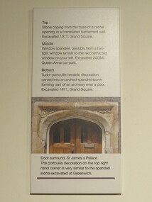
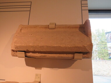
The picture on the sign shows the door surround, St James's Palace. the portcullis decoration on the top right hand corner is very similar to the spandrel stone excavated at Greenwich. Top shows the stone coping at the base of a crenel opening in a crenellated battlement wall, excavated in 1971 in the grand square; the middle shows the window spandrel, possibly from a two light window similar to the reconstructed window excavated in 2005/6 in the Queen Anne car park; and the bottom shows the tudor portcullis heraldic decoration, carved into an arched spandrel stone formng part of an archway over a door. This was excavated in 1971 in the Grand Square. greenwich, stone, museum, chapel -
 Ballarat Heritage Services
Photograph - Colour, Greenwich Chapel and Museum, England
The picture on the sign shows the door surround, St James's Palace. the portcullis decoration on the top right hand corner is very similar to the spandrel stone excavated at Greenwich. Top shows the stone coping at the base of a crenel opening in a crenellated battlement wall, excavated in 1971 in the grand square; the middle shows the window spandrel, possibly from a two light window similar to the reconstructed window excavated in 2005/6 in the Queen Anne car park; and the bottom shows the tudor portcullis heraldic decoration, carved into an arched spandrel stone formng part of an archway over a door. This was excavated in 1971 in the Grand Square. greenwich, stone, museum, chapel -
 Ballarat Tramway Museum
Postcard, Valentine & Sons Publishing Co, "Lydiard Street showing George Hotel Ballarat", 1931
Valentine Series postcard of the early 1930s of No. 27 inbound in Lydiard St Nth. Valentine series No. 1492, with the caption "Lydiard Street showing George Hotel, Ballarat". See page 59 of The Golden City and its Tramways and for the photo itself. Photo shows the wooden centre poles, street lighting, tram 27 in ESCo colour scheme, and buildings on the west side of Lydiard St North, including the George Hotel, A.M. Palmer & Co Chemist, Wm Hiscock Dentist and other buildings. A horse-drawn cart and two motor cars parked at the kerb. See 3893 for a digital image and reproduction photograph.Yields information about Lydiard St Nth in the 1930's, the centre poles, traffic and the appearance of the trams.Postcard black and white, divided back. Card No. 1492Has on the rear in pencil "KT" and "to be copied" tramways, trams, tram 27, lydiard st nth, george hotel, centre poles -
 Ballarat Tramway Museum
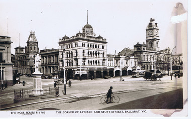
Photograph - Digital image, Rose Stereograph Co, "Corner of Lydiard and Sturt Streets, Ballarat", c1929
Digital image titled "The Corner of Lydiard and Sturt Streets Ballarat Vic", photo looks south west from the Post Office steps towards the south west corner - has Craigs Hotel, National Mutual Life, town hall shops including Anderson Printer and the Town Hall in the picture along with Robbie Burns statue. The Rose Series Postcard No. P 1783. An ESCo tram is parked at the tram stop - No. 5? A number of horse drawn and motor vehicles are in the photograph. Wal has dated the photo about 1930 on the rear of the postcard and about 1929 in his album notes. See item 9193 for a copy print.Yields information the buildings, buildings and scene at the intersection of Sturt and Lydiard St with a number of vehicles in the view.Digital image from the Wal Jack Ballarat Album of a postcard .trams, tramways, esco, lydiard st, sturt st, town hall, tram 5 ? -
 Kew Historical Society Inc
Plan, Melbourne & Metropolitan Board of Works : Borough of Kew : Detail Plan No.1576, 1904
The Melbourne and Metropolitan Board of Works (MMBW) plans were produced from the 1890s to the 1950s. They were crucial to the design and development of Melbourne's sewerage and drainage system. The plans, at a scale of 40 feet to 1 inch (1:480), provide a detailed historical record of Melbourne streetscapes and environmental features. Each plan covers one or two street blocks (roughly six streets), showing details of buildings, including garden layouts and ownership boundaries, and features such as laneways, drains, bridges, parks, municipal boundaries and other prominent landmarks as they existed at the time each plan was produced. (Source: State Library of Victoria)This plan forms part of a large group of MMBW plans and maps that was donated to the Society by the Mr Poulter, City Engineer of the City of Kew in 1989. Within this collection, thirty-five hand-coloured plans, backed with linen, are of statewide significance as they include annotations that provide details of construction materials used in buildings in the first decade of the 20th century as well as additional information about land ownership and usage. The copies in the Public Record Office Victoria and the State Library of Victoria are monochrome versions which do not denote building materials so that the maps in this collection are invaluable and unique tools for researchers and heritage consultants. A number of the plans are not held in the collection of the State Library of Victoria so they have the additional attribute of rarity.Original survey plan, issued by the MMBW to a contractor with responsibility for constructing sewers in the area identified on the plan within the Borough of Kew. The plan was at some stage hand-coloured, possibly by the contractor, but more likely by officers working in the Engineering Department of the Borough and later Town, then City of Kew. The hand-coloured sections of buildings on the plan were used to denote masonry or brick constructions (pink), weatherboard constructions (yellow), and public buildings (grey). Development in the 20th century has irreparably altered that part of Kew represented in this plan. In the block bounded by Cotham Road, Charles Street, Wellington Street and Gellibrand; just one house standing in 1903 remains. This block included two of the most historic houses in Kew: ‘Ordsall’ (later ‘Southesk’) and ‘Madford’ (previously ‘Elm Lodge’). Ordsall was the home of the second chairman of Kew, John Halfey. It contained some of the most significant interior murals in Kew, created for Halfey by artists working for Cullen & Co. It was demolished in 1960 to make way for the Kew Civic Centre. Elm Lodge had been built for William Siddeley in ca. 1864. Arthur Septimus King purchased it in 1874. The lower paddocks of Madford were sold in 1905 by his wife to the Borough of Kew and, after landscaping by George and Thomas Pockett, opened as the Alexandra Gardens in 1908. Elm Lodge/Madford was in 1922 to become St. Anthony’s Home for Little Children before its subsequent demolition in the 1980s.melbourne and metropolitan board of works, detail plans, maps - borough of kew, mmbw 1576, cartography -
 Kew Historical Society Inc
Plan, Borough of Kew Detail Plan No.1577, 1904
The Melbourne and Metropolitan Board of Works (MMBW) plans were produced from the 1890s to the 1950s. They were crucial to the design and development of Melbourne's sewerage and drainage system. The plans, at a scale of 40 feet to 1 inch (1:480), provide a detailed historical record of Melbourne streetscapes and environmental features. Each plan covers one or two street blocks (roughly six streets), showing details of buildings, including garden layouts and ownership boundaries, and features such as laneways, drains, bridges, parks, municipal boundaries and other prominent landmarks as they existed at the time each plan was produced. (Source: State Library of Victoria)This plan forms part of a large group of MMBW plans and maps that was donated to the Society by the Mr Poulter, City Engineer of the City of Kew in 1989. Within this collection, thirty-five hand-coloured plans, backed with linen, are of statewide significance as they include annotations that provide details of construction materials used in buildings in the first decade of the 20th century as well as additional information about land ownership and usage. The copies in the Public Record Office Victoria and the State Library of Victoria are monochrome versions which do not denote building materials so that the maps in this collection are invaluable and unique tools for researchers and heritage consultants. A number of the plans are not held in the collection of the State Library of Victoria so they have the additional attribute of rarity.Original survey plan, issued by the MMBW to a contractor with responsibility for constructing sewers in the area identified on the plan within the Borough of Kew. The plan was at some stage hand-coloured, possibly by the contractor, but more likely by officers working in the Engineering Department of the Borough and later Town, then City of Kew. The hand-coloured sections of buildings on the plan were used to denote masonry or brick constructions (pink), weatherboard constructions (yellow), and public buildings (grey). MMBW Plan No.1577 includes some of the most significant houses in Kew: Herbert Henty’s ‘Roxeth’ (now part of Trinity Grammar), ‘Butleigh Wooton’, ‘Bokara’ and ‘Harrow’. It also includes the streets that have since changed their names. That part of College Parade linked to Glenferrie Road is now named College Place, College Parade now extends further north, and Charles Street did not yet reach Barkers Road. Roxeth is one of a number of Henty houses in Kew. Herbert Henty made his home here and was elected a member of Kew Municipal Council in 1864 and mayor in 1868-69. Walter Henry Serle, of Harrow served in the First World War. He was awarded the Military Medal ‘’For conspicuous bravery and devotion to duty. On 29th September near BELLICOURT he showed the greatest bravery and determination when his platoon was attacked by enemy bombing parties. It was due largely to his personal efforts that all the attacks were repulsed. Until wounded, his utter disregard of personal safety and boldness in dealing with the attacks were the means of saving the situation and were an inspiring example to his men.’melbourne and metropolitan board of works, detail plans, maps - borough of kew, mmbw 1577, cartography -
 Kew Historical Society Inc
Plan, Melbourne & Metropolitan Board of Works : Borough of Kew : Detail Plan No.1578, 1904
The Melbourne and Metropolitan Board of Works (MMBW) plans were produced from the 1890s to the 1950s. They were crucial to the design and development of Melbourne's sewerage and drainage system. The plans, at a scale of 40 feet to 1 inch (1:480), provide a detailed historical record of Melbourne streetscapes and environmental features. Each plan covers one or two street blocks (roughly six streets), showing details of buildings, including garden layouts and ownership boundaries, and features such as laneways, drains, bridges, parks, municipal boundaries and other prominent landmarks as they existed at the time each plan was produced. (Source: State Library of Victoria). This plan forms part of a large group of MMBW plans and maps that was donated to the Society by the Mr Poulter, City Engineer of the City of Kew in 1989. Within this collection, thirty-five hand-coloured plans, backed with linen, are of statewide significance as they include annotations that provide details of construction materials used in buildings in the first decade of the 20th century as well as additional information about land ownership and usage. The copies in the Public Record Office Victoria and the State Library of Victoria are monochrome versions which do not denote building materials so that the maps in this collection are invaluable and unique tools for researchers and heritage consultants. A number of the plans are not held in the collection of the State Library of Victoria so they have the additional attribute of rarity.Original survey plan, issued by the MMBW to a contractor with responsibility for constructing sewers in the area identified on the plan within the Borough of Kew. The plan was at some stage hand-coloured, possibly by the contractor, but more likely by officers working in the Engineering Department of the Borough and later Town, then City of Kew. The hand-coloured sections of buildings on the plan were used to denote masonry or brick constructions (pink), weatherboard constructions (yellow), and public buildings (grey). MMBW Plan No.1578 is significant in that it defines the extent of two private schools: Xavier College and Kew High School (now part of Trinity Grammar) by 1904. In relation to the latter, the plan clarifies which buildings the High School operated from behind the mansion ‘Molina’. Established in 1902, Trinity Grammar was to later lease and subsequently buy Molina (now ‘Merritt House’) and ‘Elsinore’ (now ‘Roberts House’). Xavier College had been established in 1872. This 1904 plan delineates the West Wing and the Great Hall (built in 1890).melbourne and metropolitan board of works, detail plans, maps - borough of kew, mmbw 1578, cartography -
 Kew Historical Society Inc
Plan, Melbourne & Metropolitan Board of Works. Borough of Kew Detail Plan No.1579, 1904
The Melbourne and Metropolitan Board of Works (MMBW) plans were produced from the 1890s to the 1950s. They were crucial to the design and development of Melbourne's sewerage and drainage system. The plans, at a scale of 40 feet to 1 inch (1:480), provide a detailed historical record of Melbourne streetscapes and environmental features. Each plan covers one or two street blocks (roughly six streets), showing details of buildings, including garden layouts and ownership boundaries, and features such as laneways, drains, bridges, parks, municipal boundaries and other prominent landmarks as they existed at the time each plan was produced. (Source: State Library of Victoria). This plan forms part of a large group of MMBW plans and maps that was donated to the Society by the Mr Poulter, City Engineer of the City of Kew in 1989. Within this collection, thirty-five hand-coloured plans, backed with linen, are of statewide significance as they include annotations that provide details of construction materials used in buildings in the first decade of the 20th century as well as additional information about land ownership and usage. The copies in the Public Record Office Victoria and the State Library of Victoria are monochrome versions which do not denote building materials so that the maps in this collection are invaluable and unique tools for researchers and heritage consultants. A number of the plans are not held in the collection of the State Library of Victoria so they have the additional attribute of rarity.Original survey plan, issued by the MMBW to a contractor with responsibility for constructing sewers in the area identified on the plan within the Borough of Kew. The plan was at some stage hand-coloured, possibly by the contractor, but more likely by officers working in the Engineering Department of the Borough and later Town, then City of Kew. The hand-coloured sections of buildings on the plan were used to denote masonry or brick constructions (pink), weatherboard constructions (yellow), and public buildings (grey). While MMBW Plan No.1579 does not include many buildings, those that it does show are significant to Kew’s history. These include the ‘Kew [Railway] Station’ in Denmark Street and the ‘Recreation Hall’ and rear courts off Wellington Street. The plan shows the outline of the Recreation Hall, constructed in 1880, at the rear of which is listed a bowling green, two tennis courts, a ‘skittle alley’ and a pavilion. When the Hall was first built, the Kew Cricket Club occupied an adjacent ground, however in 1885 this was acquired by the State Government as the future location of the Kew Railway Station. The Plan also shows a single oval at Xavier College. This oval was completed in 1883. One of the current ovals conforms to this oval’s original shape and position in the school grounds.melbourne and metropolitan board of works, detail plans, maps - borough of kew, mmbw 1579, cartography -
 Kew Historical Society Inc
Plan, Melbourne and Metropolitan Board of Works, Borough of Kew : Detail Plan No.1580, 1904
The Melbourne and Metropolitan Board of Works (MMBW) plans were produced from the 1890s to the 1950s. They were crucial to the design and development of Melbourne's sewerage and drainage system. The plans, at a scale of 40 feet to 1 inch (1:480), provide a detailed historical record of Melbourne streetscapes and environmental features. Each plan covers one or two street blocks (roughly six streets), showing details of buildings, including garden layouts and ownership boundaries, and features such as laneways, drains, bridges, parks, municipal boundaries and other prominent landmarks as they existed at the time each plan was produced. (Source: State Library of Victoria)This plan forms part of a large group of MMBW plans and maps that was donated to the Society by the Mr Poulter, City Engineer of the City of Kew in 1989. Within this collection, thirty-five hand-coloured plans, backed with linen, are of statewide significance as they include annotations that provide details of construction materials used in buildings in the first decade of the 20th century as well as additional information about land ownership and usage. The copies in the Public Record Office Victoria and the State Library of Victoria are monochrome versions which do not denote building materials so that the maps in this collection are invaluable and unique tools for researchers and heritage consultants. A number of the plans are not held in the collection of the State Library of Victoria so they have the additional attribute of rarity.Original survey plan, issued by the MMBW to a contractor with responsibility for constructing sewers in the area identified on the plan within the Borough of Kew. The plan was at some stage hand-coloured, possibly by the contractor, but more likely by officers working in the Engineering Department of the Borough and later Town, then City of Kew. The hand-coloured sections of buildings on the plan were used to denote masonry or brick constructions (pink), weatherboard constructions (yellow), and public buildings (grey). The area represented in this detail plan has undergone significant change during the 20th century. The widening of High Street in the 1930s and 1950s involved the shops on the south side of High Street being demolished and later rebuilt to fit the widened street. Another significant loss was the mansion ‘Drayton’ fronting Wellington Street, owned at this stage by Susannah Fenton. Her family name would later to be given to Fenton Way, which was to be built over the grounds of the house following its demolition. The plan of the garden is particularly interesting, containing a batten dome fronting Wellington Street, an ornamental pond, a fountain and a brick and glass conservatory. The notes by the plumbing contractor on this plan are particularly detailed. Pink borders delineate the ownership of the varying parcels of land. Some of the better known owners listed include the real estate agent Cr. Henry de Castres Kellett (bt) and John Padbury, the funeral director. This particular plan provides a clear view of the configuration of the Kew Junction in 1903 and the commercial buildings that surrounded it.melbourne and metropolitan board of works, detail plans, maps - borough of kew, mmbw 1580, cartography -
 Kew Historical Society Inc
Plan, Melbourne & Metropolitan Board of Works : Borough of Kew : Detail Plan No.1581, 1904
The Melbourne and Metropolitan Board of Works (MMBW) plans were produced from the 1890s to the 1950s. They were crucial to the design and development of Melbourne's sewerage and drainage system. The plans, at a scale of 40 feet to 1 inch (1:480), provide a detailed historical record of Melbourne streetscapes and environmental features. Each plan covers one or two street blocks (roughly six streets), showing details of buildings, including garden layouts and ownership boundaries, and features such as laneways, drains, bridges, parks, municipal boundaries and other prominent landmarks as they existed at the time each plan was produced. (Source: State Library of Victoria)This plan forms part of a large group of MMBW plans and maps that was donated to the Society by the Mr Poulter, City Engineer of the City of Kew in 1989. Within this collection, thirty-five hand-coloured plans, backed with linen, are of statewide significance as they include annotations that provide details of construction materials used in buildings in the first decade of the 20th century as well as additional information about land ownership and usage. The copies in the Public Record Office Victoria and the State Library of Victoria are monochrome versions which do not denote building materials so that the maps in this collection are invaluable and unique tools for researchers and heritage consultants. A number of the plans are not held in the collection of the State Library of Victoria so they have the additional attribute of rarity.Original survey plan, issued by the MMBW to a contractor with responsibility for constructing sewers in the area identified on the plan within the Borough of Kew. The plan was at some stage hand-coloured, possibly by the contractor, but more likely by officers working in the Engineering Department of the Borough and later Town, then City of Kew. The hand-coloured sections of buildings on the plan were used to denote masonry or brick constructions (pink), weatherboard constructions (yellow), and public buildings (grey). The streets and built structures in this plan were surveyed in 1903 and released to contractors in 1904. In addition to the designation of building types by colour, the plan includes detailed descriptions of land use and ownership. While many buildings remain from this period, a number of the buildings represented have been demolished including the original Kew Town Hall, and the Congregational and Roman Catholic churches in Walpole Street. While the mansion ‘Illapa’ in Princess Street is still extant – now part of ‘Rylands’ – the neighbouring mansion ‘Elsmere’ was demolished some decades ago. Rivalling Illapa and Elsmere in size were two mansions in Walpole Street, one named on the plan as ‘Gnarlbine’. Over time, Kew Junction and the south side of High Street have been reconfigured and widened, so that the commercial buildings on the corner of Princess and High Street no longer exist. A surprising feature of this part of central Kew to the northwest of Kew Junction is the amount of vacant land. In a number of cases, this land is noted by the contractor as used for vegetable gardens.melbourne and metropolitan board of works, detail plans, maps - borough of kew, mmbw 1581, cartography -
 Kew Historical Society Inc
Plan, Melbourne & Metropolitan Board of Works : Borough of Kew : Detail Plan No.1582, 1904
The Melbourne and Metropolitan Board of Works (MMBW) plans were produced from the 1890s to the 1950s. They were crucial to the design and development of Melbourne's sewerage and drainage system. The plans, at a scale of 40 feet to 1 inch (1:480), provide a detailed historical record of Melbourne streetscapes and environmental features. Each plan covers one or two street blocks (roughly six streets), showing details of buildings, including garden layouts and ownership boundaries, and features such as laneways, drains, bridges, parks, municipal boundaries and other prominent landmarks as they existed at the time each plan was produced. (Source: State Library of Victoria)This plan forms part of a large group of MMBW plans and maps that was donated to the Society by the Mr Poulter, City Engineer of the City of Kew in 1989. Within this collection, thirty-five hand-coloured plans, backed with linen, are of statewide significance as they include annotations that provide details of construction materials used in buildings in the first decade of the 20th century as well as additional information about land ownership and usage. The copies in the Public Record Office Victoria and the State Library of Victoria are monochrome versions which do not denote building materials so that the maps in this collection are invaluable and unique tools for researchers and heritage consultants. A number of the plans are not held in the collection of the State Library of Victoria so they have the additional attribute of rarity.Original survey plan, issued by the MMBW to a contractor with responsibility for constructing sewers in the area identified on the plan within the Borough of Kew. The plan was at some stage hand-coloured, possibly by the contractor, but more likely by officers working in the Engineering Department of the Borough and later Town, then City of Kew. The hand-coloured sections of buildings on the plan were used to denote masonry or brick constructions (pink), weatherboard constructions (yellow), and public buildings (grey). Public buildings, coloured grey on the Plan 1582 include the police station and post office, churches and schools. The earliest church school, Common School No.356 was located at the rear of the Congregational Church in Peel Street. It was constructed in 1859. The first buildings of Kew Primary School No.1075 on the other side of Peel Street were constructed in 1871. The school in 1903 only occupied a small fraction of its current site. In 1903, where the rear playground is now located, were two weatherboard and one brick villa. Trinity Grammar School was founded in 1902 and opened in the Parish Hall at the rear of Holy Trinity Anglican Church. It was not to move to its current site until 1906. The outline of the building housing the Kew Fire Brigade in the centre of the north side of Walton Street is shown but not named on the plan. Further down Pakington Street stood the two-storey Italianate mansion ‘Overton’. The home of Stanford Chapman, it was to be featured in the Imperial Institute series of bromide photographs of Victoria, Vol. 1: Homes and scenery. It was later to become a boarding house before it was later demolished.melbourne and metropolitan board of works, detail plans, maps - borough of kew, mmbw 1582, cartography -
 Kew Historical Society Inc
Plan, Melbourne & Metropolitan Board of Works : Borough of Kew : Detail Plan No.1585, 1904
The Melbourne and Metropolitan Board of Works (MMBW) plans were produced from the 1890s to the 1950s. They were crucial to the design and development of Melbourne's sewerage and drainage system. The plans, at a scale of 40 feet to 1 inch (1:480), provide a detailed historical record of Melbourne streetscapes and environmental features. Each plan covers one or two street blocks (roughly six streets), showing details of buildings, including garden layouts and ownership boundaries, and features such as laneways, drains, bridges, parks, municipal boundaries and other prominent landmarks as they existed at the time each plan was produced. (Source: State Library of Victoria)This plan forms part of a large group of MMBW plans and maps that was donated to the Society by the Mr Poulter, City Engineer of the City of Kew in 1989. Within this collection, thirty-five hand-coloured plans, backed with linen, are of statewide significance as they include annotations that provide details of construction materials used in buildings in the first decade of the 20th century as well as additional information about land ownership and usage. The copies in the Public Record Office Victoria and the State Library of Victoria are monochrome versions which do not denote building materials so that the maps in this collection are invaluable and unique tools for researchers and heritage consultants. A number of the plans are not held in the collection of the State Library of Victoria so they have the additional attribute of rarity.Original survey plan, issued by the MMBW to a contractor with responsibility for constructing sewers in the area identified on the plan within the Borough of Kew. The plan was at some stage hand-coloured, possibly by the contractor, but more likely by officers working in the Engineering Department of the Borough and later Town, then City of Kew. The hand-coloured sections of buildings on the plan were used to denote masonry or brick constructions (pink), weatherboard constructions (yellow), and public buildings (grey). This plan, which covers parts of High Street, Pakington Street and Derby Street is dominated by two historic Kew mansions: ‘Konetta’ and ‘Ramornie’. Ramornie was constructed in 1890 for James Maitland Campbell, three times Mayor of Kew. Sold in 1940, it became a boarding house known as ‘The Towers’. Now a private residence again, it has only one of its three balconies remaining. The location of the missing two balconies can be seen on the plan. In 1903, the grounds of Ramornie included a large tennis court fronting Pakington Street. The rear of the property is shown as extending to Cobden Street. One of Kew’s oldest hotels, the Prospect Hill Hotel on the corner of High and Cobden Street was established in 1858. The outline of the hotel shown on the plan represents the second building on the site. During the 19th century it was often used for electoral meetings. The Prospect Hill Hotel was to be redeveloped again in 1928, by the local architect Robert McIntyre. Since the 1980s, the hotel has been a live music venue, the home of the Melbourne Jazz Club, a restaurant and a liquor outlet.melbourne and metropolitan board of works, detail plans, maps - borough of kew, mmbw 1585, cartography -
 Kew Historical Society Inc
Plan, Melbourne & Metropolitan Board of Works : Borough of Kew : Detail Plan No.1588, 1904
The Melbourne and Metropolitan Board of Works (MMBW) plans were produced from the 1890s to the 1950s. They were crucial to the design and development of Melbourne's sewerage and drainage system. The plans, at a scale of 40 feet to 1 inch (1:480), provide a detailed historical record of Melbourne streetscapes and environmental features. Each plan covers one or two street blocks (roughly six streets), showing details of buildings, including garden layouts and ownership boundaries, and features such as laneways, drains, bridges, parks, municipal boundaries and other prominent landmarks as they existed at the time each plan was produced. (Source: State Library of Victoria)This plan forms part of a large group of MMBW plans and maps that was donated to the Society by the Mr Poulter, City Engineer of the City of Kew in 1989. Within this collection, thirty-five hand-coloured plans, backed with linen, are of statewide significance as they include annotations that provide details of construction materials used in buildings in the first decade of the 20th century as well as additional information about land ownership and usage. The copies in the Public Record Office Victoria and the State Library of Victoria are monochrome versions which do not denote building materials so that the maps in this collection are invaluable and unique tools for researchers and heritage consultants. A number of the plans are not held in the collection of the State Library of Victoria so they have the additional attribute of rarity.Original survey plan, issued by the MMBW to a contractor with responsibility for constructing sewers in the area identified on the plan within the Borough of Kew. The plan was at some stage hand-coloured, possibly by the contractor, but more likely by officers working in the Engineering Department of the Borough and later Town, then City of Kew. The hand-coloured sections of buildings on the plan were used to denote masonry or brick constructions (pink), weatherboard constructions (yellow), and public buildings (grey). This plan shows the original configuration of the Kew Post Office, Court House and Police Station, which had opened in 1888. This configuration was to essentially remain until the purchase of the Court House and Police Station by the City of Boroondara in 2007 and its subsequent renovation. Interestingly, the MMBW surveyors incorrectly labelled parts of the complex. In the triangle in front of the Post Office, before the erection of the Kew Cenotaph in 1925, was located a lawn and the Queen Victoria Jubilee Fountain. While many of the shops on the south side of High street had been constructed by 1903 a number of sites were still used as vegetable gardens. Further along High Street, on the corner of Charles Street, the Salvation Army Barracks can be seen on the plan. These Barracks predate the later Citadel and ‘Young People’s Hall’ that were opened in 1919. At 22 Charles Street can be seen the house of James Venn Morgan. Hailed as the ‘father of Kew’, Morgan arrived in Melbourne in 1840. He was first engaged as a bookmaker, but a fortunate venture on the goldfields enabled him to purchase land in Kew. He conducted a market garden and dairy in Kew for many years.melbourne and metropolitan board of works, detail plans, maps - borough of kew, mmbw 1588, cartography -
 Kew Historical Society Inc
Plan, Melbourne & Metropolitan Board of Works : Borough of Kew : Detail Plan No.1592, 1905
The Melbourne and Metropolitan Board of Works (MMBW) plans were produced from the 1890s to the 1950s. They were crucial to the design and development of Melbourne's sewerage and drainage system. The plans, at a scale of 40 feet to 1 inch (1:480), provide a detailed historical record of Melbourne streetscapes and environmental features. Each plan covers one or two street blocks (roughly six streets), showing details of buildings, including garden layouts and ownership boundaries, and features such as laneways, drains, bridges, parks, municipal boundaries and other prominent landmarks as they existed at the time each plan was produced. (Source: State Library of Victoria). This plan forms part of a large group of MMBW plans and maps that was donated to the Society by the Mr Poulter, City Engineer of the City of Kew in 1989. Within this collection, thirty-five hand-coloured plans, backed with linen, are of statewide significance as they include annotations that provide details of construction materials used in buildings in the first decade of the 20th century as well as additional information about land ownership and usage. The copies in the Public Record Office Victoria and the State Library of Victoria are monochrome versions which do not denote building materials so that the maps in this collection are invaluable and unique tools for researchers and heritage consultants. A number of the plans are not held in the collection of the State Library of Victoria so they have the additional attribute of rarity.Original survey plan, issued by the MMBW to a contractor with responsibility for constructing sewers in the area identified on the plan within the Borough of Kew. The plan was at some stage hand-coloured, possibly by the contractor, but more likely by officers working in the Engineering Department of the Borough and later Town, then City of Kew. The hand-coloured sections of buildings on the plan were used to denote masonry or brick constructions (pink), weatherboard constructions (yellow), and public buildings (grey). In MMBW Plan No.1592, the pink line indicates that area of the plan for which the contracting engineer was responsible. Included in the Plan are a number of primarily brick villas in a section of Belmont Avenue off Cotham Road. The house ‘Uvadale’ north of Belmont Avenue, and facing Cotham Road is also included in the contract. Excluded from the contract but shown on the Plan are ‘Glendonald’, ‘Mont Belmont’ and ‘Gilden’.melbourne and metropolitan board of works, detail plans, survey plans - borough of kew, mmbw 1592, cartography -
 Kew Historical Society Inc
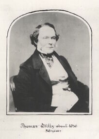
Photograph - Photograph [copy], Thomas Wills about 1856, 56 years, 1856
Wills Street in the Kew ward of Studley Park was named after Thomas Wills. This work forms part of the collection assembled by the historian Dorothy Rogers, that was donated to the Kew Historical Society by her son John Rogers in 2015. The manuscripts, photographs, maps, and documents were sourced by her from both family and local collections or produced as references for her print publications. Many were directly used by Rogers in writing ‘Lovely Old Homes of Kew’ (1961) and 'A History of Kew' (1973), or the numerous articles on local history that she produced for suburban newspapers. Most of the photographs in the collection include detailed annotations in her hand.The Rogers Collection provides a comprehensive insight into the working habits of a historian in the 1960s and 1970s. Together it forms the largest privately-donated collection within the archives of the Kew Historical SocietyA copy of a portrait of Thomas Wills, aged 56 years. Wills was an early landowner in Kew.Thomas Wills - Born Sydney 1799. Built Willsmere Farm ca. 1850thomas wills, kew, dorothy rogers, wills street, wills family -
 Kew Historical Society Inc
Plan, Melbourne & Metropolitan Board of Works : Borough of Kew : Detail Plan No.1296, 1904
The Melbourne and Metropolitan Board of Works (MMBW) plans were produced from the 1890s to the 1950s. They were crucial to the design and development of Melbourne's sewerage and drainage system. The plans, at a scale of 40 feet to 1 inch (1:480), provide a detailed historical record of Melbourne streetscapes and environmental features. Each plan covers one or two street blocks (roughly six streets), showing details of buildings, including garden layouts and ownership boundaries, and features such as laneways, drains, bridges, parks, municipal boundaries and other prominent landmarks as they existed at the time each plan was produced. (Source: State Library of Victoria)This plan forms part of a large group of MMBW plans and maps that was donated to the Society by the Mr Poulter, City Engineer of the City of Kew in 1989. Within this collection, thirty-five hand-coloured plans, backed with linen, are of statewide significance as they include annotations that provide details of construction materials used in buildings in the first decade of the 20th century as well as additional information about land ownership and usage. The copies in the Public Record Office Victoria and the State Library of Victoria are monochrome versions which do not denote building materials so that the maps in this collection are invaluable and unique tools for researchers and heritage consultants. A number of the plans are not held in the collection of the State Library of Victoria so they have the additional attribute of rarity.Original survey plan, issued by the MMBW to a contractor with responsibility for constructing sewers in the area identified on the plan within the Borough of Kew. The plan was at some stage hand-coloured, possibly by the contractor, but more likely by officers working in the Engineering Department of the Borough and later Town, then City of Kew. The hand-coloured sections of buildings on the plan were used to denote masonry or brick constructions (pink), weatherboard constructions (yellow), and public buildings (grey). This area was once known as O’Shaughnessy’s Paddock. O’Shaughnessy was the licensee of the Kew Hotel. The ‘Paddock’ or farm was for many years the closest farm to Melbourne. By 1903, when this plan was surveyed and lithographed, little of the farm remained. The area is dominated by a ‘clay hole’, on the site of the current Foley Reserve. It was used by Smart’s Brickyard from the 1880s until 1911, when the Council purchased it for a rubbish dump. It is notable as the site is one of the few industrial operations to have existed in Kew. By 1903, urban development was characterised by larger houses fronting Barkers Road and brick and weatherboard villas in Foley Street. Nearer the pit, weatherboard houses predominated. Foley Street bisected the triangular block and continued right to Denmark Street. At this stage, a house impeded the through road, only allowing access via a right of way to High Street.melbourne and metropolitan board of works, detail plans, mmbw 1296, cartography -
 Kew Historical Society Inc
Plan, Melbourne & Metropolitan Board of Works : Borough of Kew : Detail Plan No.1297, 1904
The Melbourne and Metropolitan Board of Works (MMBW) plans were produced from the 1890s to the 1950s. They were crucial to the design and development of Melbourne's sewerage and drainage system. The plans, at a scale of 40 feet to 1 inch (1:480), provide a detailed historical record of Melbourne streetscapes and environmental features. Each plan covers one or two street blocks (roughly six streets), showing details of buildings, including garden layouts and ownership boundaries, and features such as laneways, drains, bridges, parks, municipal boundaries and other prominent landmarks as they existed at the time each plan was produced. (Source: State Library of Victoria)This plan forms part of a large group of MMBW plans and maps that was donated to the Society by the Mr Poulter, City Engineer of the City of Kew in 1989. Within this collection, thirty-five hand-coloured plans, backed with linen, are of statewide significance as they include annotations that provide details of construction materials used in buildings in the first decade of the 20th century as well as additional information about land ownership and usage. The copies in the Public Record Office Victoria and the State Library of Victoria are monochrome versions which do not denote building materials so that the maps in this collection are invaluable and unique tools for researchers and heritage consultants. A number of the plans are not held in the collection of the State Library of Victoria so they have the additional attribute of rarity.Original survey plan, issued by the MMBW to a sewage contractor with responsibility for constructing sewers in the area identified on the plan within the Borough of Kew. The plan was at some stage hand-coloured, possibly by the contractor, but more likely by officers working in the Engineering Department of the Borough and later Town, then City of Kew. The hand-coloured sections of buildings on the plan were used to denote masonry or brick constructions (pink), weatherboard constructions (yellow), and public buildings (grey). This plan of Kew encompasses the area bounded by Barkers Road, High Street and Stevenson Street. Because of the angle created by High Street, a number of houses on the northern side of High Street are shown. The area is dominated by one of the great original landholdings in Kew, described here as the ‘Findon Paddock’. ‘Findon’, the house from which the name of the paddock was taken fronts Stevenson Street and was clearly a rambling structure. The best-known occupant of Findon was Henry ‘Money Miller’ who bought the house in 1871. Miller was a member of Victoria’s first parliament and assisted in the framing of its constitution. Findon was to be subdivided as early as 1912, when the Findon Subdivision was advertised to be sold by auction. In the plan of the subdivision, the original house is not shown, so, presumably it had previously been demolished. Fincham & Son moved the organ, built by Henry Willis, which was installed in the house, first to ‘Whernside’ in Toorak, and later to the Box Hill Methodist Church.melbourne and metropolitan board of works, detail plans, mmbw 1297, cartography, kew (vic.) — municipal collection -
 Kew Historical Society Inc
Plan, Melbourne & Metropolitan Board of Works : Borough of Kew : Detail Plan No.1301, 1910
The Melbourne and Metropolitan Board of Works (MMBW) plans were produced from the 1890s to the 1950s. They were crucial to the design and development of Melbourne's sewerage and drainage system. The plans, at a scale of 40 feet to 1 inch (1:480), provide a detailed historical record of Melbourne streetscapes and environmental features. Each plan covers one or two street blocks (roughly six streets), showing details of buildings, including garden layouts and ownership boundaries, and features such as laneways, drains, bridges, parks, municipal boundaries and other prominent landmarks as they existed at the time each plan was produced. (Source: State Library of Victoria)This plan forms part of a large group of MMBW plans and maps that was donated to the Society by the Mr Poulter, City Engineer of the City of Kew in 1989. Within this collection, thirty-five hand-coloured plans, backed with linen, are of statewide significance as they include annotations that provide details of construction materials used in buildings in the first decade of the 20th century as well as additional information about land ownership and usage. The copies in the Public Record Office Victoria and the State Library of Victoria are monochrome versions which do not denote building materials so that the maps in this collection are invaluable and unique tools for researchers and heritage consultants. A number of the plans are not held in the collection of the State Library of Victoria so they have the additional attribute of rarity.Original survey plan, issued by the MMBW to a contractor with responsibility for constructing sewers in the area identified on the plan within the Borough of Kew. The plan was at some stage hand-coloured, possibly by the contractor, but more likely by officers working in the Engineering Department of the Borough and later Town, then City of Kew. The hand-coloured sections of buildings on the plan were used to denote masonry or brick constructions (pink), weatherboard constructions (yellow), and public buildings (grey). Throughout its history, the land in what is known today as Studley Ward of the City of Boroondara has been subject to continuing subdivision. This is evident in Plan 1301, where later hands have modified the original map to include streets created subsequent to the printing of the plan in 1904. Other annotations such as the ‘Reserved for Road Purposes’ beside the Yarra never eventuated. The plan continued to be modified to at least 1953, when a later hand noted that a particular site was ‘Property site P. McIntyre house’ in Swinton Avenue. Two significant houses in the area are outlined on the plan: ‘Swinton’ on the corner of the streets then named Effey and Maud Streets (now Swinton Avenue) and ‘Fairhaven’ [unnamed] in Stevenson Street. The gardens of the two David Syme owned mansions of ‘Blythswood’ and ‘Rockingham’, stretching down to the River Yarra, are also represented.melbourne and metropolitan board of works, detail plans, mmbw 1301, cartography -
 Kew Historical Society Inc
Plan, Melbourne & Metropolitan Board of Works : Borough of Kew : Detail Plan No.1561, 1905
The Melbourne and Metropolitan Board of Works (MMBW) plans were produced from the 1890s to the 1950s. They were crucial to the design and development of Melbourne's sewerage and drainage system. The plans, at a scale of 40 feet to 1 inch (1:480), provide a detailed historical record of Melbourne streetscapes and environmental features. Each plan covers one or two street blocks (roughly six streets), showing details of buildings, including garden layouts and ownership boundaries, and features such as laneways, drains, bridges, parks, municipal boundaries and other prominent landmarks as they existed at the time each plan was produced. (Source: State Library of Victoria). This plan forms part of a large group of MMBW plans and maps that was donated to the Society by Mr Poulter, City Engineer of the City of Kew in 1989. Within this collection, thirty-five hand-coloured plans, backed with linen, are of statewide significance as they include annotations that provide details of construction materials used in buildings in the first decade of the 20th century as well as additional information about land ownership and usage. The copies in the Public Record Office Victoria and the State Library of Victoria are monochrome versions which do not denote building materials so that the maps in this collection are invaluable and unique tools for researchers and heritage consultants. A number of the plans are not held in the collection of the State Library of Victoria so they have the additional attribute of rarity.Original survey plan, issued by the MMBW to a contractor with responsibility for constructing sewers in the area identified on the plan within the Borough of Kew. The plan was at some stage hand-coloured, possibly by the contractor, but more likely by officers working in the Engineering Department of the Borough and later Town, then City of Kew. The hand-coloured sections of buildings on the plan were used to denote masonry or brick constructions (pink), weatherboard constructions (yellow), and public buildings (grey). MMBW Detail Plan 1561 outlines those residences in the area bordered by Burke Road, Loxton Street, Mount Street and Barkers Road that had been constructed by 1905 when the land was surveyed. At this time, the area nearest Burke Road had been subdivided and developed whereas the lands to the west were as yet undeveloped. The houses represented are not named on the Plan.melbourne and metropolitan board of works, detail plans, mmbw 1561, cartography