Showing 15537 items matching " corner"
-
 City of Ballarat Libraries
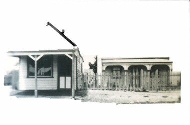
Photograph - Card Box Photographs, E. Jenkins Butcher shop, Sebastopol circa 1916
E. Jenkins Butcher shop and family cottage in Albert Street, Sebastopol. The shop was built in 1880s. In the late 1920s, the butcher shop was moved further north along Albert Street to the corner opposite what is now the Ford dealership e. jenkins butcher, albert street, sebastopol, ballarat, commerical, building, cottage, private dwelling -
 Kew Historical Society Inc
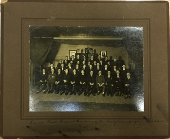
Photograph, Reunion , Past and Present Members of Kew Presbyterian Young Mens' Bible Class, 1924, 1924
The Kew Presbyterian Church was located in Cotham Road, Kew on the corner of Highbury Grove. The Church Hall was located next door in Highbury Grove. On amalgamating with the Uniting Church the buildings became redundant and are now the Kew Chinese Baptist Church.Original photograph from 1924 that records the preoccupations of committed church goers in Kew in th e1920s.Posed photograph of Reunion of Past and Present Members of Kew Presbyterian Young Men's Bible Class. The men are seated in 5 rows on a raised wooden floor. Wooden board hanging on the wall behind the men reads Presbyterian Church of Victoria. Possibly the church hall with stage curtains On front Reunion Past and Present Members of Kew Presbyterian Young Mens' Bible Class. 1924" On reverse "Reunion Some of the Past and Present Members Oct 1924. Unclear ?YMBC"kew presbyterian church, presbyterian churches - kew (vic), bible classes -
 Kew Historical Society Inc
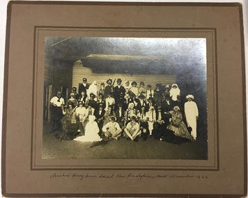
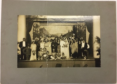
Photograph, Fancy Dress Social, Kew Presbyterian Church Hall, 1922, 11/1922
The Kew Presbyterian Church was located in Cotham Road, Kew on the corner of Highbury Grove. The Church Hall was located next door in Highbury Grove. On amalgamating with the Uniting Church the buildings became redundant and are now the Kew Chinese Baptist Church.Original photograph from the 1930s that records the kinds of social and spiritual actions of church goers in Kew. Group photograph of participants in a fancy dress social at the Kew Presbyterian Church Hall in 1922. It is believed that the group was the Young Men's Bible Class who held this event annually. The Society has photographs of the event in 1922 and 1925.Later hand: "Masked Fancy Dress Social, Kew Presbyterian Hall, November 1922"presbyterian church - kew (vic), kew presbyterian church - young men's bible class, churches - social activities - 1920s -
 Kew Historical Society Inc
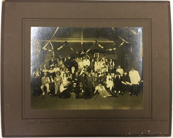
Photograph, Fancy Dress Social, Kew Presbyterian Church Hall, Kew, 1925, 1925
The Kew Presbyterian Church was located in Cotham Road, Kew on the corner of Highbury Grove. The Church Hall was located next door in Highbury Grove. On amalgamating with the Uniting Church the buildings became redundant and are now the Kew Chinese Baptist Church.Original photograph from the 1930s that records the kinds of social and spiritual actions of church goers in Kew.Group photograph of young men in attendance at a fancy dress social at the Kew Presbyterian Church Hall in 1925. The photo would indicate that the event was a young men only event. The Society has photographs of the event in 1922 and 1925.Later hand: "1925. Annual Fancy Dress Social. Kew Presbyterian Young Men's Bible Class"presbyterian church - kew (vic), kew presbyterian church - young men's bible class, churches - social activities - 1920s -
 Kew Historical Society Inc
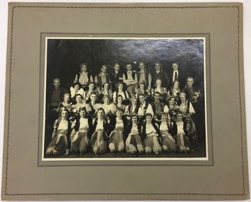
Photograph, Cast Members, Kew Presbyterian Church, 1925-1935
The Kew Presbyterian Church was located in Cotham Road, Kew on the corner of Highbury Grove. The Church Hall was located next door in Highbury Grove. On amalgamating with the Uniting Church the buildings became redundant and are now the Kew Chinese Baptist Church.Original photograph from the 1930s that records the kinds of social and spiritual actions of church goers in Kew.Members of the cast of a performance take a certain call at the end of a performance. The item was part of a group of photos relating to the Kew Presbyterian Church, so it may show a performance in which members of the church participated or led. The location of the performance is unclear; it might be at the Kew Recreation Centre or in the Kew Presbyterian Church Hall. Intriguingly, what look to be bunya bunya pines appear in the distance above the proscenium. The photograph was originally identified as possibly being the Kew Light Opera Company, however the photograph precedes its foundation. It is more likely to be a performance by a church group.cast photographs, theatre - melbourne -
 Kew Historical Society Inc
Photograph, Photograph of the Assembled Cast, 1925-1935
The Kew Presbyterian Church was located in Cotham Road, Kew on the corner of Highbury Grove. The Church Hall was located next door in Highbury Grove. On amalgamating with the Uniting Church the buildings became redundant and are now the Kew Chinese Baptist Church.Original photograph from the 1930s that records the kinds of social and spiritual actions of church goers in Kew.Members of the cast of an unidentified performance, probably during the 1930s in Kew, pose for a group photograph. The photograph was originally identified as possibly being the Kew Light Opera Company, however the photograph precedes its foundation. It is more likely to be a performance by a church group.cast photographs, theatre - melbourne -
 Kew Historical Society Inc
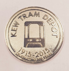
Souvenir - Medallion, Kew Tram Depot 1915-2015, 2015
Kew tram depot is located on the corner of Barkers Road and High Street, Kew, a suburb of Melbourne, Australia. Operated by Yarra Trams, it is one of eight tram depots on the Melbourne tram network. The depot opened on 8 May 1915.Commemorative medallion in blue presentation box, given to the Kew Historical Society on the anniversary of the Kew Depot in 2015.Front: Schematic engraving of tram with the words "Kew Tram Depot : 1915-2015 : Celebrating 100 Years". Reverse: Schematic engraving of exterior of Depot, surrounded by the words "Commemorating all staff who have contributed to the success of Kew Depot".kew tram depot, commemorative medallions, tramways memorabilia -
 Port Fairy Historical Society Museum and Archives
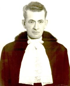
Photograph - Portrait photograph, Hill, Alexander George Mayor of Borough of Port Fairy 1944 1945 1962 1970
Alexander George Hill Mayor 1944 1945 1962 1970 His home and boot shop was in Sackville Street - first shop from the old Post office corner. Alex was very involved in the Port Fairy Football Club.Black & white portrait of Alexander Hill wearing mayoral robes and jabotmayor, government, shire, council, municipal, portrait, local government, football club -
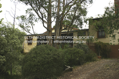 Eltham District Historical Society Inc
Photograph - Digital Photograph, Alan King, Southernwood, cnr Bolton and Brougham Street, Eltham, 30 January 2008
Walter Withers once lived at the corner of Bolton and Brougham Streets, Eltham. Covered under Heritage Overlay, Nillumbik Planning Scheme. Published: Nillumbik Now and Then / Marguerite Marshall 2008; photographs Alan King with Marguerite Marshall.; p105This collection of almost 130 photos about places and people within the Shire of Nillumbik, an urban and rural municipality in Melbourne's north, contributes to an understanding of the history of the Shire. Published in 2008 immediately prior to the Black Saturday bushfires of February 7, 2009, it documents sites that were impacted, and in some cases destroyed by the fires. It includes photographs taken especially for the publication, creating a unique time capsule representing the Shire in the early 21st century. It remains the most recent comprehenesive publication devoted to the Shire's history connecting local residents to the past. nillumbik now and then (marshall-king) collection, bolton steet, brougham steet, eltham, southernwood, walter withers house -
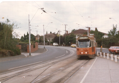 Melbourne Tram Museum
Photograph - Z1 49 Riversdale Rd Hawthorn, George Bishop, 1-1-1979
Photograph shows Z1 No. 49 (City Princes Bridge, route 70) at the corner of Riversdale Road, Wallen Road and Power Street. Shows the crossover that was subsequently relocated to Wallen Road. Photo George Bishop, 1-1-1979Yields information about the operation of Z1 class trams on route 70.Colour photograph - Z1 49 Riversdale Rd HawthornDetails of the photograph and photographer on the rear in ink.trams, tramways, z1 class, tram 49, riversdale road, wallen road, power street, route 70 -
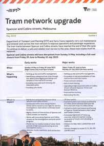 Melbourne Tram Museum
Pamphlet, Public Transport Victoria (PTV), "Tram Network upgrade - Spencer and Collins St", May 2023
Issued for trackwork at the corner of Spencer St and Collins St, track replacement including a portion in Spencer St. Major works undertaken between Friday 30 June and Monday 10 July 2023. Produced by Yarra Trams and the PTV.Yields information about track work during 2023.Set of two notices - printed on A3 paper folded to A4trackwork, spencer st, collins st, tramways -
 Lakes Entrance Historical Society
Photograph - Historic House, 2000
House built on Rogby Island by Mitchelson around 1915, relocated to corner of Lake Street and Barkes Avenue around 1920, then to Phillips Street 1962. Front window altered, veranda frieze removed, side extension of veranda removed.Colour photograph of a timber residence at 3 Phillips Street. Gable roof, fibro cement section under gables. Front door has fanlight above, widow light beside door filled in. Barge board of gables typical of dwellings built by Leo Mitchelson, Lakes Entrance Victoriahouses, heritage study -
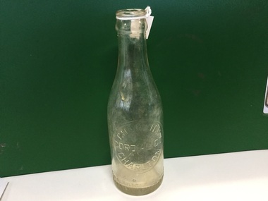 Charlton Golden Grains Museum Inc
Container - Charlton Cordial Co. Glass Bottle, Charlton Cordial Company, Circa late 19th Century
The bottle represents the cordial making industry that existed in Charlton during the late 1800's, early 1900's. We are unsure of the site of the factory, but the local iceworks existed into the 1960's. It was located on the corner of Camp and Armstrong Streets. This is important because it represents an industry that existed in Charlton many years ago. It would have been an early form of today's soft drink.Clear glass bottle. With an embossed label reading "Charlton Cordial Co. Charlton'Charlton Cordial Co This bottle always remains the property of Cordial Company of Charlton. F 1335glass bottle, cordial bottle, charlton, business, industry -
 Federation University Historical Collection
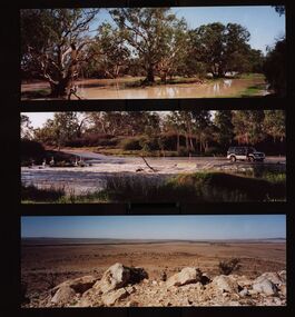
Photograph - Colour, Chatham-Holmes Collection: Outback Tour, 2003, 2003
Tour to outback regions of Australia - Innamincka and Cameron Corner. This is where the Queensland, New South Wales and South Australia borders meet. Photos show the floods, dryness of the land and the regeneration of plant life. Elizabeth Chatham is with family memberschatham-holmes collection, elizabeth chatham, outback, cameron corner, innamincka, queensland, new south wales, south australia, floods, desert plants -
 Flagstaff Hill Maritime Museum and Village
Currency - Engravers Plate, Five-pound
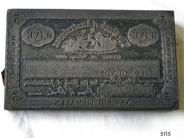
This banknote plate was created for the Sydney branch of the Bank of Australasia in February 1900, before the Federation of Australia. After printing the banknotes from this plate the printer would have overprinted the banknotes with a unique serial number and the denomination of the banknote in capital letters using a contrasting ink. The Bank of Australasia was incorporated by Royal Charter of England in March 1834. It first came to Australia on 14th December 1835, opening in Sydney. In that year, the Acting Superintendent of the Bank of Australasia in Sydney was David Charters McArthur. He went on to become the Superintendent from 1867-to 1876. The Melbourne branch of the Bank of Australasia opened on 28th August 1838. In 1951 the Bank of Australasia amalgamated with the Union Bank to form the Australia and New Zealand Bank, now known as the ANZ. Then in 1970 the ANZ merged with both the ES&A and the London Bank of Australia to form the ANZ Banking Group Limited. The ANZ Banking Group Ltd kindly donated a variety of historic items from the Bank of Australasia. BANK of AUSTRALASIA, WARRNAMBOOL – The Bank of Australasia was the first bank in Warrnambool. It was established in 1854 and operated from leased buildings on Merri Street and then Timor Street. The bank opened its own building on May 21, 1860, on the northeast corner of Timor and Kepler Streets. Mr A Butt was the Manager of the Warrnambool Branch in 1895. This significant item of early Australian social history gives a snapshot into the founding and early development of the banking system in Australia. The plate has historical significance as it belonged to the Bank of Australasia which was established in 1834 by Royal Charter and opened in Sydney, Australia, in Sydney in 1835. The plate is significant for its association with the Bank of Australasia, which had a branch in Warrnambool. Warrnambool's branch was the first bank in Warrnambool, established in 1854. The bank continued to operate until its merger in 1951 when it became the ANZ Bank, which is still in operation today. The Bank was an integral part of the establishment and growth of commerce in Colonial Warrnambool and throughout Australia.Printer's plate for a five-pound note, attached to a block comprising several layers of different varieties of wood. Rectangular metal plate embossed with the banknote's design and produced by the Sydney, New South Wales, branch of the Bank of Australasia. The border includes numbers and text. The image of the bank's logo is included, along with the banknote's denomination in letters and numerals, a signature and a date of 15th February 1900.On the border: in each corner "5", on sides and base "NEW SOUTH WALES" Within the border "FIVE" "The Bank of Australasia / INCORPORATED BY ROYAL CHARTER IN 1835" "FIVE POUNDS' "SYDNEY 5th of February 1900" "for the Bank of Australasia" (Signature) , "MANAGER" Image: (Bank's logo) [Two female figures seated together in a paddock, produce beside them, sheep and buildings in the background]flagstaff hill, warrnambool, shipwrecked coast, flagstaff hill maritime museum, maritime museum, shipwreck coast, flagstaff hill maritime village, great ocean road, bank of australasia, union bank, australia & new zealand bank, anz bank, sydney, new south wales, currency, banknote, legal tender, commerce, banking, five-pound note, banknote plate, printing plate -
 Ballarat Tramway Museum
Photograph - Colour Photograph/s, David Endacott, 19/09/1971 12:00:00 AM
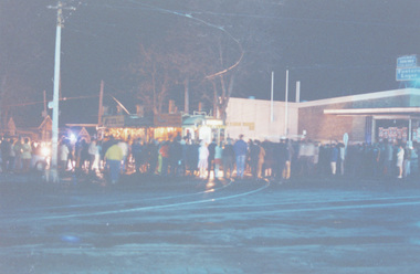
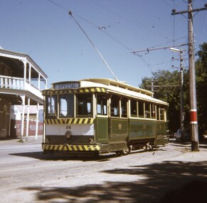
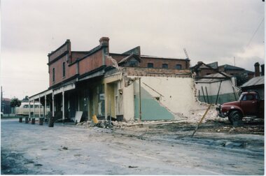
Two colour prints (Copies 1 and 2) of the scene at the Hospital Corner, Drummond St. Sth and Sturt St. after the running of the last tram from Sebastopol prior to running into the depot on 19 Sept. 1971. Shows one bogie tram No. 40 (from the advertising boards) with many people at the corner. Possibly taken after the police car has moved on, prior to the tram leaving for the depot after a few minutes. Has the liquor store on the south west corner of the intersection in the background. Tram is heavily loaded with passengers. Copy 1on Fujicolour Crystal Archive Paper is the better exposed and larger print and has been used in the scanned image.. Copy 2 another print off the same negative but with a smaller photograph area. Original film image scanned at 3200dpi 12/5/2020.On copy 2 - "Last tram to run in Ballaarat at Cnr Drummond & Sturt Sts on way to depot." in black ink.sebastopol, last tram, closure, hospital corner, tram 40 -
 Ballarat Tramway Museum
Slide - 27 mm sq slide/s - set of 5, Andrew Howlett, Tram 26 on private tour - View Point line, Mar. 1969
Yields information about a special tram service during March 1969 and some unusual moves.Set of four Colour slides, Kodak white cardboard mount, developed March 1969 of a special tram that apparently ran from the depot via View Point, shunted at Ripon St and again at Hospital corner. ..1 - No. 26 running a special in Wendouree Parade, View Point, with the Lake View Hotel. .2 - ditto - and a catering company in the view, as well as a Telephone box. .3 - running from Ripon St into Sturt St. .4 - shunting at Hospital corner - then possibly crossed 34 at Parker St Loop - see 7668. .5 - ditto, but before .4, with the tram rounding the corner from the North side of Sturt St into Drummond St. It would then appear that the tram then reversed a bit before going back into Sturt St onto the South side. One of a series of tour photos - see Reg item 7667, 7668, 7683 and 7701.ballarat, tramways, trams, view point, wendouree parade, ripon st, hospital corner, sturt st, tours, tram 26 -
 Melbourne Tram Museum
Photograph - Set of 9 Colour Print/s, 31/08/1997 12:00:00 AM
Set of nine colour photographs on Kodak Paper of the 31-8-1997 National Trust event of the opening of Hawthorn Depot with heritage trams "Trams in Hiding". Taken by an unknown photographer - see history of object. .1- Photo of the corner of the depot showing the advertising board for the event, sponsored by Woodards and event information. .2 - HTT 8 at the Riversdale Rd tram stop with the depot in the background. .3 - A231 at the Riversdale Rd tram stop with the depot in the background. .4 - looking at the depot from the corner of Riversdale Rd and Power St. .5 - V214 at depot .6 - Looking at the depot building east end from across the garden in the small median strip on the corner of Riversdale Rd and Power St. .7 - V214 leaving the depot .8 - trams at the front of the shed - V214, 1040, 821 and 469 .9 - HTT 8, at depottrams, tramways, hawthorn, national trust, open days, tram 8, tram 231, tram 214, tram 1040, tram 821, tram 469 -
 Warrnambool and District Historical Society Inc.
souvenir cup, Warrnambool Congregational Church
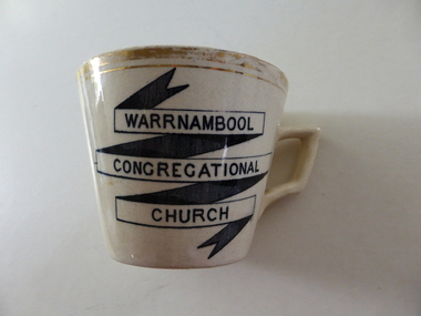
The Warrnambool Congregational Church was established with a meeting called in April 1862 and over the ensuing months a congregation with first pastor Rev W Pentland was established. After initially meeting at the small Temperence Hall in Liebig St, land was purchased at the corner of Liebig and lava St and the first church opened in March 1864. It remained on this site until the site was sold to the T & G Assurance in 1939 and land known as Kianga Estate was purchased on the corner of Lava and Henna Streets.It became part of the amalgamation with other churches to form the Uniting Church in 1977.This cup is possibly a souvenir from the 50th anniversary celebrations held in 1912. A common object which is linked to one of warrnambool's longest running churches.Cream china cup with thick gold rim and black test in banner style on one side of the cup. Warrnambool Congregational Church on front of cup . 338 written on bottom and 4 on paper labelwarrnambool, warrnambool congregational church -
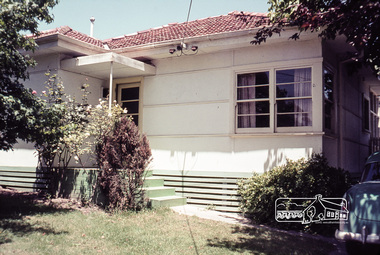
 Eltham District Historical Society Inc
Negative - Photograph, Bridge Street, Eltham, c.1910
View from Maria Street (Main Road) along Bridge Street, Eltham, looking towards Montmorency. The house on the right at the corner of Susan and Bridge streets was owned for many years by the Hill family until Council bought it in the early 1960s. The house was built in the 1850s or 60s. The house on the left stood on what is now the southwest corner of Susan and Bridge Streets. The Braithwaite family was associated with this house. Orchards in the foreground either side of the Diamond Creek. The line of trees running up the hill to the left represents the Bolton street alignment. Based on hand writing of title on image compared with others, date is estimated at c.1910.This photo forms part of a collection of photographs gathered by the Shire of Eltham for their centenary project book,"Pioneers and Painters: 100 years of the Shire of Eltham" by Alan Marshall (1971). The collection of over 500 images is held in partnership between Eltham District Historical Society and Yarra Plenty Regional Library (Eltham Library) and is now formally known as the 'The Shire of Eltham Pioneers Photograph Collection.' It is significant in being the first community sourced collection representing the places and people of the Shire's first one hundred years.Digital image 4 x 5 inch B&W Negshire of eltham pioneers photograph collection, bolton steet, braithwaite, bridge, bridge street, bridge street bridge, eltham, hill family home, susan street, orchards -
 Eltham District Historical Society Inc
Photograph, First house in Pryor Street, Eltham, c.1965, 1965c
This was the first house on Pryor Street which was located at the corner of what is now Commercial Place on the eastern side. Originally there was another house adjacent but it had been moved by the time of the 1951 aerial survey. The house was also the first home of Russell Yeoman who had been newly appointed to the Shire of Eltham and this house belonging to the council was vacant and made available to him for four weeks before it was relocated to Susan Street just south of the bowls club and was used a child care centre associated with the Living and Learning Centre (Russell believes). Russell then moved into another council owned house at the corner of Susan and Bridge Streets.Digital file only; created from original colour positive slide transparencyeltham, streets, houses, pryor street, susan street, fe holden sedan, russell yeoman collection -
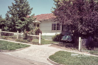 Eltham District Historical Society Inc
Photograph, First house in Pryor Street, Eltham, c.1965, 1965c
This was the first house on Pryor Street which was located at the corner of what is now Commercial Place on the eastern side. Originally there was another house adjacent but it had been moved by the time of the 1951 aerial survey. The house was also the first home of Russell Yeoman who had been newly appointed to the Shire of Eltham and this house belonging to the council was vacant and made available to him for four weeks before it was relocated to Susan Street just south of the bowls club and was used a child care centre associated with the Living and Learning Centre (Russell believes). Russell then moved into another council owned house at the corner of Susan and Bridge Streets.Digital file only; created from original colour positive slide transparencyeltham, streets, houses, pryor street, susan street, russell yeoman collection, fc holden sedan -
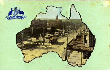 Ballarat Tramway Museum
Postcard, H&B, Sturt St with an ESCo tram westbound, 1910's?
Postcard with a view of Sturt St with an ESCo tram westbound, taken from corner with Doveton St, looking east within an embossed map Australia - no Tasmania. Coat of arms also embossed. Has words "Sturt St Ballarat, Looking East" within photograph. In top left hand corner, has Australian Coat of Arms, partially embossed, printed in blue. Same photograph as in Reg Item 838 and similar to Reg Item 4003 and written originally by the same person. On rear, the post card has been divided into two with a the words "Commonwealth of Australia and Post Card" and artistic symbol with the initials "H&B".Early Commonwealth of Australia postcard, after the Post Master General's department formed late 1900's. See also Reg item 4003.Printed coloured / black and white postcard.On rear in ink " Happy New Year, from Ern & Lucys children to Mum" ????trams, tramways, sturt st, doveton st, esco, postcards -
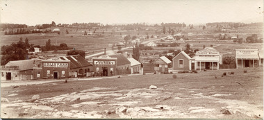 The Beechworth Burke Museum
Photograph, c1900
Taken around 1858, depicting a row of five business buildings on a rocky, sloping hillside at New Town, with a view across to residences and open land. Businesses included, Joseph E. Bishop, Coach Builders; Straughair Duncan, Engineers, Blacksmiths & Farriers; Straughair Duncan, Beechworth Foundry; Wholesale & Retail Est. 1855, Mackenzie Family Store ; and T. Pratten, Grocer. The Mental Hospital can be seen in the background. Mark Straughair and John Duncan, established the Beechworth Foundry, Newtown in 1858 and went on to build an important industry, employing around sixteen men, after acquiring Alexander Roger's New Ford Street Foundry in the late 1860s. Making and repairing mostly mining and agricultural machinery for the Ovens District and a Beechworth brewery, the business continued to function after Straughair's death in 1882, up until the death of Duncan in 1896, when the business folded. This photograph is historically significant because it shows the development of the businesses in Beechworth from the early establishment of the town.Sepia rectangular photograph printed on photographic paper mounted on boardObverse: [Pin holes from circular tacks in all four corners] Reverse: 84.216-1/ Newtown/ 1997.2650/ 21/ BMM3056/new town, newtown, newtown beechworth, local business, 1858, 1850s beechworth, joseph e. bishop, coach builder, coach, mark straughair, m. straughair, straughair and duncan, john duncan, j. duncan, beechworth foundry, mackenzie family store, t. pratten, grocer, beechworth grocers, beechworth mental asylum, beechworth mental hospital, mayday hills mental asylum, mental hospital, alexander rogers, new ford street foundry, 1860s beechworth, 1860s, mining machinery, agricultural machinery, manufacturing, bridge road -
 Mission to Seafarers Victoria
Letter - Correspondence, 15/02/1944
A letter written from Charles Quinn to his mother in 1944 which depicts his time spent in Melbourne before he travelled to San Francisco This letter is of historical, social and interpretive significance as it provides information about the life of a seaman during the mid 20th century. Two page letter (0300.A1-A2) from Allan Quinn to his mother, written on lined paper in 1944. Inscription on top right hand corner which states: "M.I. Goonawarra/Melbourne 15.2.44" in black ink followed by letter contentallan quinn, mission to seafarers, 1944, letter, melbourne -
 Ringwood and District Historical Society
4 Coloured photographs numbered 10043 to 10046, Demolition of buildings in Adelaide Street -Ringwood. Circa 1960
Postcard size coloured photograph"Written on back of photograph" Demolition of buildings in Adelaide Street - including Bloods Emporium on corner of Maroondah Highway . Early 1960's -
 Eltham District Historical Society Inc
Photograph, Former Eltham Police Residence, 728 Main Road, Eltham, c.1985, 1985c
This photo is believed to have been taken circa 1985 when the Shire of Eltham Parks and Environment occupied the site. This photo was originally mounted on 3mm MDF fibre board with notes and stickers applied as part of a display on the former Police Residence and now present day Local History Centre, home to Eltham District Historical Society; possibly put together by Harry Gilham during his time as president of the society. Eltham Police Station and Residence: A brief history 1860 Eltham Courthouse built in Main Road, together with an adjoining police residence, office, lock–up and stables. 1959 Police Department purchases a house in Pryor Street to be refurbished as Eltham Police Station 1961 Police in Eltham move into Pryor Street refurbished buildings and office. c.1961-1981 Occupied by Vermin and Noxious Weeds Destruction Section of the Department of Crown Lands and Survey. Former Police Station dragged around to rear of Police Residence (prior to August 1967) to make way for the construction of a driveway and access from Main Road. The building was placed on the site of a former Scullery and modified for Lands Department use. 1981 Shire of Eltham take over management of old Police Residence in Eltham. It remains unoccupied for a period of time whilst its future is discussed in Council. 1981-1985 Used for community job creation scheme 1985 Shire of Eltham Parks and Environment occupy the residence. Council improve the driveway but later add a second rear access from Brougham Street due to the dangerous nature of the Main Road entrance. Also add a rear toilet facility between the Police Residence and former Police Station, which was doubling up as a lunch room. Council also commence discussions to re-establish a replica Police Station. c.1986 November. Former Police Station demolished; believed to have been suffering termite damage. c.1989 After some years of discussion a replica Police Station is built, based on photographs, to act as a lunch room and meeting room for Parks and Environment staff and volunteers doing community service. 1996 Eltham District Historical Society in discussions with Nillumbik Shire Council commisioners throughout the year regarding a home for the Society. A proposal put forward by the Society in October to occupy the former Police Residence. 1997 March. Eltham District Historical Society gains access to former Police Residence. 1998 July 12th. Eltham District Historical Society Inc moves into its Local History Centre, 728 Main Road Eltham (the former Police Residnce built in 1860). 2018 July. Eltham District Historical Society gains access to the replica Police Station for use as part of regular heritage tours for schools and community based groups.Colour printHandwritten in faded blue felt pen ink "Repeat view of No. 4 from external corner of weatherboard extn. Room 5"728 main road, eltham, local history centre, parks and environment, police residence, police station, shire of eltham -
 Lara RSL Sub Branch
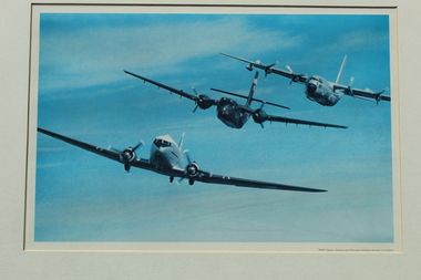
photograph R. A. A. F. Aircraft, R.A.A.F. Aircraft- Dakota, Caribou, and Hercules Transport Aircraft in formation
Photograph of R.A.A.F. Aircraft- Dakota, Caribou, and Hercules Transport Aircraft in formation.Title of photograph located lower right hand corner of photo, R.A.A.F. Aircraft- Dakota, Caribou, and Hercules Transport Aircraft in formation.photograph of r.a.a.f. aircraft- dakota, caribou, and hercules transport aircraft in formation. -
 Mission to Seafarers Victoria
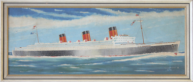
Painting, C V Wright, RMS Queen Mary, 1971
RMS Queen Mary a retired ocean liner by 1971 that sailed primarily on the North Atlantic Ocean from 1936 to 1967 for the Cunard Line (known as Cunard-White Star Line when the vessel entered service ( Wikipedia) Maritime ArtLong framed unglazed landscape format painting predominantly depicting in foreground an ocean liner painted black hull and white superstructure with three funnel stacks painted red with black trim, under full sail against a blue sky. The back of the painting is covered with brown paper in places damaged. Hangs on a cotton cord threaded between two screw in eyelet hooks. Brown paper backingat lower right corner single uc word in white paint : "CV WRIGHT (artist symbol of crossed anchors) / 3 ? '71"marine painting, ocean liners, rms queen mary, royal mail ships, p & o steamships, ww2, artwork-paintings, hobbies, bosun, c.v. wright -
 Mission to Seafarers Victoria
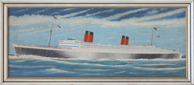
Painting, RMS Queen Elizabeth, 1971
RMS Queen Elizabeth that sailed primarily on the North Atlantic Ocean from 1939 to 1968 for the Cunard Line , later owned by the Queen Corpration and then the Seawise University. Queen Elizabeth was a slightly larger ship (than the Queen Mary) , the largest passenger liner ever built at that time and for 56 years thereafter. She also has the distinction of being the largest-ever riveted ship by gross tonnage. She first entered service in February 1940 as a troopship in World War II, and it was not until October 1946 that she served in her intended role as an ocean liner. With the decline in popularity of the transatlantic route, both ships were replaced by the smaller. Queen Elizabeth was sold to a succession of buyers, and finally was sold to Hong Kong businessman of the Orient Overseas line in 1970. In 1972, whilst she was undergoing refurbishment in Hong Kong harbour, fire broke out aboard under unexplained circumstances, and the ship was capsized by the water used to fight the fire.Marine artLong framed unglazed landscape format painting predominantly depicting in foreground an ocean liner painted black hull and white superstructure with two funnel stacks painted red with black trim, under full sail against a blue sky. The back of the painting is covered with brown paper in places damaged. Hanging cord missing . Remnant Brown paper backing.at lower right corner single uc word in white paint : "CV WRIGHT (artist symbol of crossed anchors) / 3 ? '71"marine painting, ocean liners, rms queen mary, royal mail ships, p & o steamships, ww2, artwork-paintings, hobbies, bosun, c.v.wright