Showing 11430 items
matching maps
-
 Tatura Irrigation & Wartime Camps Museum
Booklet, History of the Waranga Basin, 1989 (reprint)
Includes details of construction of Waranga systemBuff soft covered book with map of Waranga Basin and text in brown Written by Joyce Hammond giving historical information from aboriginal presence to the situation in 1977 with reference to members of the Gunn and Hammond familiesirrigation, boat club, books, history, local -
 Victorian Aboriginal Corporation for Languages
Book, Anne Robertson, Treasures of the State Library of New South Wales : the Australiana collections, 1988
Treasures from the State Library of New South Wales. The history of the David Scott Mitchell collection. Shows pictures of maps, furniture, prints, newspapers etc. from the very earliest of white settlement in Sydney.document reproductions, colour illustrations, b&w illustrations, b&w photographs, colour photographsdavid scott mitchell, mitchell library, sir william dixson, dixson library, special collections -
 Whitehorse Historical Society Inc.
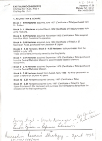
Letter - Correspondence, East Burwood Reserve, 1993
Various documents relating to the establishment of East Burwood ReserveVarious documents relating to the establishment of East Burwood Reserve including acquisition of land, details, plans, locality map, news cuttings and photographs. Appears to be copy of Nunawading City Council File April 1993Various documents relating to the establishment of East Burwood Reserve sportsgrounds, east burwood reserve, soilleur (dr), hitchens, anna, blue moon fruit co-operative ltd., jacobson and logan, king family, central methodist mission, aussat, tally ho, sewart, bill -
 Whitehorse Historical Society Inc.
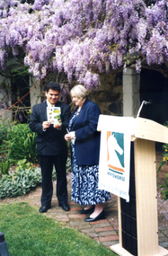
Photograph, Launch of Valley of the Arts Tourist Map, 1/10/2000 12:00:00 AM
Coloured photo of Minister for Tourism, John Pandazopoulos and Mayor of City of Whitehorse, Cr, Jessie MacCallum at launch of Co-operative venture Valley of the Arts Tourist Map at Schwerkolt Cottage on 6th October 2000.pandazopoulos, john, maccallum. jessie, city of whitehorse, valley of the arts, schwerkolt cottage. -
 Otway Districts Historical Society
Book, Ken Jenkins, Beech Forest: a century on The Ridge
Beech Forest: a century on The Ridge. Norman Houghton. ISBN 0 959013 1 3. Soft cover. 56p.; illus, map, graph, sketch. March 1984. Publisher: Beech Forest Centenary Committee -
 Otway Districts Historical Society
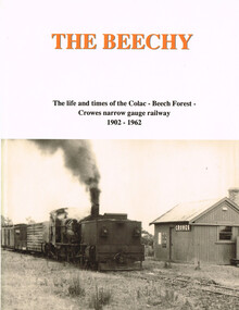
Book, The Beechy, 1992
The Beechy. The life and times of the Colac-Beech Forest-Crowes narrow gauge railway, 1902-1962; Norman Houghton; hard cover; viii, 176 p.; illus., maps; ISBN 0909340 28 5Printing - McPherson's Printing Group; Typesetting - Mackenzies Typesetting.the beechy; colac; beech forest; crowes; narrow gauge railway; norman houghton; locomotive operations; traffic; timber tramways; otway people; the garrett; trolley traffic; lean 1930s; -
 Otway Districts Historical Society
Book, "Drink up, Gents." Norman Houghton, 2011
"Drink up, Gents". A history of hotels in Colac and District, 1841 to 2011. Norman Houghton. ISBN 978-0-9593013-8-0. Soft cover. iv, 88 p.; illus, maps, diagrams."drink up, gents."; hotels in colac and district; colac; apollo bay; beech forest; lavers hill; birregurra; forrest; wye river; wine shanties; norman houghton; -
 Otway Districts Historical Society
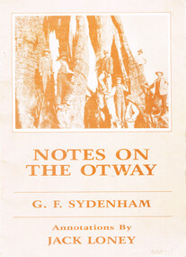
Book, J.K. Loney, Notes on the Otways. G.F. Sydenham, 1987
Notes on the Otways. G.F. Sydenham. J.F. Loney (comp.) 1st ed. J.K. Loney;np; 1987. 36 p.; illus., map. Soft cover. ISBN 0 909191 3 6 0otways; g.f. sydenham; j.k. loney; forests; roads; country roads board; timber; dairying; cape otway lighthouse; -
 Otway Districts Historical Society
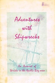
Book, Adventures with shipwrecks
An account shipwrecks from 1880 to 1958 in the Apollo Bay area.Adventures with shipwrecks. An account of wrecks in the Apollo Bay area. J.K. Loney. 1st ed. Apollo Bay (Vic); J.K. Loney; nd. 20 p.; illus, map. Soft cover.222mm x apollo bay; j.k. loney; shipwrecks;, apollo bay; j.k. loney; shipwrecks; -
 Otway Districts Historical Society
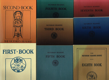
Book, Government Printer, The Victorian Readers, 1986
These eight books that make up The Victorian Readers, one for each of the grades that then comprised the primary school, were first published by the Victorian Education Department between 1928 and 1930. Second editions of all but the First Book, with a few changes in content, appeared some ten years later. One-quarter of the content was required to be Australian with the remainder from Britain, the United States and Europe. Beginning in the 1950s new Departmental publications gradually replaced the old books with the exception of the Fifth and Sixth books which survived until the late 1960s, when commercially-produced reading material finally took over in schools. The Victorian Readers: Books 1 to 8. Facsimile reprint. Ministry of Education (Schools Division); Melbourne (Vic); 1986. Various p.; illus; maps. Soft cover. ISBN 0 7306 0859 Xvictoria; education department; readers; primary education; -
 Bendigo Historical Society Inc.
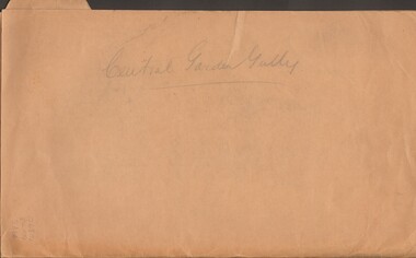
Document - MCCOLL, RANKIN AND STANISTREET COLLECTION: CENTRAL GARDEN GULLY
Manilla Folder containing correspondence and applications for a mining lease on the Garden Gully Line known as Mumford's Claim, also contains maps of lease numbers 9993, 10173, and 10390 (all on the Garden Gully Line).McColl Rankin & Stanistreet, Charing Cross Bendigogold mining, miners' safety cage, central garden gully, mining, gold mines, bendigo, garden gully, mumfords claim -
 Bendigo Historical Society Inc.
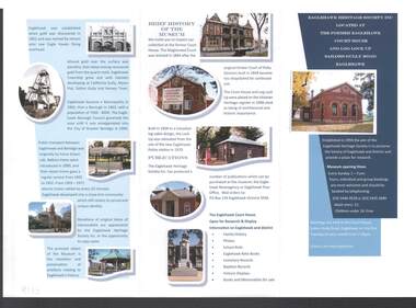
Document - EAGLEHAWK HERITAGE SOCIETY INC BROCHURE
Coloured brochure which contains a brief history of Eaglehawk, opening times for the Museum, a map with points of interest, application for Membership form, a brief history of the Museum, where Publications can be obtained and Research and Displays.eaglehawk heritage society inc brochure, former eaglehawk court house, log lock up, eaglehawk borough council, city of greter bendigo, court of petty sessions, eaglehawk newsagency, eaglehawk post office -
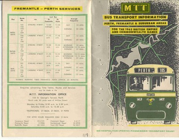 Ballarat Tramway Museum
Ephemera - Timetable and map, MTT Perth, "MTT Bus Transport Information 1962" - Perth, 1962
Colour map of Perth bus routes and trolley bus routes on soft card or heavy paper. At time of the 1962 British Empire and Commonwealth Games. Title "MTT Bus Transport Information 1962" - Perth.mtt, perth, bus routes, timetables -
Kew Historical Society Inc
Archive (Sub-series) - Subject File, Kew Historical Society, Hays Paddock (Kew East), 1958
Various partiesReference, Research, InformationSecondary Values (KHS Imposed Order)Subject file containing many newspaper/magazine articles/clippings (1979-2016), some published by the City of Boroondara, and maps, summaries of reports (KNews, 1980) and proposals to create an ‘integrated playground’ at Hays Paddock.kew historical society - archives, hays paddock - kew east (vic), parks and gardens - kew east (vic)kew historical society - archives, hays paddock - kew east (vic), parks and gardens - kew east (vic) -
 Kew Historical Society Inc
Plan - Framed Subdivision Plan (copy), F Price, Plan of Mr William Derrick's Land, Kew being Subdivision of Part of Section 86, Parish of Boroondara, County of Bourke, 1872, 1872
William Derrick was an early landowner in Kew, and with James Venn Morgan and James Dannock the purchaser of the parcel of land bounded by Cotham Road, High Street and Mary Street. Derrick Street in Kew is named after him.Map mounted under perspex. ‘Plan of Mr Willia Derrick's Land, Kew being Subdivision of Part of Section 86, Parish of Boroondara, County of Bourke’. This is a copy of the plan held in the State Library of Victoria.kew subdivision plan, john derrick, subdivision plans -- kew (vic.) -
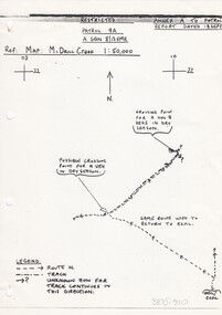 8th/13th Victorian Mounted Rifles Regimental Collection
Document - Report
In 1988, as part of a Defence of Mainland Australian policy, defence of facilities of strategic importance in northern Australia were allocated to Army Reserve units. ‘A’ Squadron was allocated the defence of Tindal Air Force base located 15 KM outside Katherine in Northern Territory. Consequently the Squadron deployed on Exercise ‘Northern Explorer’ to gain first-hand knowledge of operating conditions for mounted and dismounted patrolling in the area.Rare patrol report made by soldiers of a Victorian regiment while on exercise in Northern Territory.Report of patrol carried out by soldiers of 'A' Squadron 8/13 Victorian Mounted Rifles 18 September 1988 near Tindal Air Base Northern Territory. Six pages plus sketch map.military, patrol, tindal, northern territory, vmr -
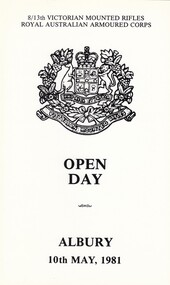 8th/13th Victorian Mounted Rifles Regimental Collection
Document
The 8th/13th Victorian Mounted Rifles was raised as a regiment of the Royal Australian Armoured Corps on 1 May 1948 with Headquarters in Melbourne and squadrons in Sale, Benalla/Wangaratta and Albury. In 1955 Regimental Headquarters moved to Wangaratta and a second squadron was located at Albury. The Sale squadron transferred to 4th/19th Prince of Wales’s Light Horse. In 1977 8/13 VMR Regiment was reduced to an independent squadron A Squadron 8th/13th Victorian Mounted Rifles and in 1991 was linked with 4th/19th Prince of Wales’s Light Horse forming the VMR Squadron of that regiment.Black and white single fold card being program for Regimental Open Day at Buna Barrack Albury, 10 May 1981. Contains brief history of Regiment, program for day and map of Buna Barracks. -
University of Melbourne, Burnley Campus Archives
Plan, Yarra 500/045.043 Municipalities of Prahran 211 and Richmond 207, 1979
Melbourne and Metropolitan Board of Works Series 1:500. Map prepared by the Survey Division, MMBW January 1979. Scale 1:500. Area surrounding Heyington Station and St. Kevin's Junior Schoolmelbourne and metropolitan board of works, prahran, richmond -
Canterbury History Group
Book, Richard Broome, Remembering Melbourne 1850-1960, 2016
A book of over 700 black and white illustrations and photographs of early Melbourne scenes, mainly buildings, which have been demolished or significantly changed. The first half of the book concentrates on the CBD but includes public gardens and the Yarra River. The second half of the book looks at a number of the inner suburbs including Footscray.Large red covered book with black and white dust cover featuring panoramic view of Princes Bridge looking North. 366 pages : photographs, 1 map, portraits. Includes bibliographical references and indexnon-fictionA book of over 700 black and white illustrations and photographs of early Melbourne scenes, mainly buildings, which have been demolished or significantly changed. The first half of the book concentrates on the CBD but includes public gardens and the Yarra River. The second half of the book looks at a number of the inner suburbs including Footscray.historical buildings - melbourne, melbourne - history, canterbury - history -
Canterbury History Group
Document - Canterbury Mansions and Stables, 13/03/1991 12:00:00 AM
Photocopy of a document relating to the Draft Statement of Significance for Canterbury Mansions. Contains a short history of Canterbury, the role the hotel has played in that history, and descriptions of the interior and exterior. Includes many photographs and 2 mapscanterbury, canterbury mansions, canterbury club hotel, canterbury road, city of boroondara, historic buildings register, jacob lewis vines, malone family, temperance movement, wattle valley road, stables, outbuildings -
Tarnagulla History Archive
Prospectus: Reef Mining NL - Tarnagulla Gold Project, Reef Mining NL - Tarnagulla Gold Project, circa 1995
Donald Clark Collection. A cardboard folder with colour image of poppethead on cover and title 'Prospectus: Reef Mining NL - Tarnagulla Gold Project'. Contained inside are maps and mining reports and other information about the Tarnagulla Gold Project.tarnagulla, gold, mining, reef mining nl -
 City of Kingston
Pamphlet - Colour, R. Malcolm Estate Agents et al, Last Chance Land Sale Heritage Estate Cheltenham, c.1994
Sales plan for land in the suburb of Cheltenham, bounded by Chesterville Road and Bernard Street, and incorporating Clendon Court, Tintern Grove and Tintern MewsThis land sale pamphlet illustrates one of the last subdivisions of the century in Cheltenham, incorporating house and land packages. It shows that land sales and subdivision for the area had slowed considerably by the end of the 1900s and that the infrastructure was significantly developed. Colour pamphlet advertising last chance land sale of Heritage Estate Cheltenham. Incorporates a map of the estate bordered by Chesterville Road and Bernard Street, and including Clenton Court, Tintern Grove and Tintern Mews.cheltenham, land sales, estate -
 City of Kingston
Pamphlet - Colour, Duffus Bros, Railway Reserve Highett, c. 1923
Sales plan for land in the suburb of Highett, titled Railway Reserve, incorporating properties along Wolseley Street, Livingston Street, Highett Road and Worthing Road. The developing urban area of Highett within the City of Kingston. This land sale pamphlet illustrates the subdivision of land within the municipality and the changing demographic of the district as new houses and shops are constructed close to infrastructure.Colour pamphlet advertising thirty eight shop and villa sites for sale at the Railway Reserve, Highett. Incorporates a map of the reserve with properties available on Wolseley Street, Livingston Street, Highett Road and Worthing Road. Handwritten in grey pencil: assumed sale price recorded on subdivisions 1-7, 10, 22, 23 and 34 Handwritten in grey pencil on subdivision 4: C. Nevill / City of Melbourne bank Handwritten in grey pencil across subdivision 7: 49' Handwritten in grey pencil across subdivision 21 and 22: 134' Handwritten in grey pencil across subdivision 25 and 26: 200' Handwritten in grey pencil across subdivision 36 and 37 and both top and bottom: 120' Hand drawn in blue pencil: outline of subdivision 4 Hand drawn in blue pencil: outline of subdivisions 7, 23, 28, 37, 38 along left hand side, subdivisions 38, 37 and 36 on Wolseley Street, subdivisions 30 and 29 along Wolseley Street, subdivisions 29 and 24 along the middle of the plan, subdivisions 24 and half of 25 along Livingston Street, half of subdivision 20 along the middle of the plan, subdivisions 21 and 22 along the Right of Way between Livingston Street and Highett Road, and along the right hand border of subdivision 7. Handwritten in ink adjacent to the subdivision plan, updside down, in the bottom right hand corner: 276 / 54 / 280 / 45 / 320 / 202 / 200 / 134 / horizontal line / 11/14 Handwritten in ink adjacent to the subdivision plan, updside down, in the bottom right hand corner: 1714)2200(15 / 1714 / horizontal line / 486land sales, highett -
Port Melbourne Historical & Preservation Society
Document - Research report, Heritage study of "Clareville" and McCormack Gallery", Robyn Clinch, Heritage Study of "Clareville"and the "McCormack Gallery" Port Melbourne, Jan 2008
Submitted as part of the requirements for the subject "Heritage Planning"at RMIT University for the degree of Master of Social Science Environment.wHeritage Study of "Clareville"and the "McCormack Gallery" Port Melbourne - A4 bound with red plastic comb. 62 pages with red back. Contains comparative studies from Port and South Melbourne, photos and mapsbuilt environment - civic, built environment - domestic, port melbourne temperance hall, town planning, heritage, robyn clinch, clareville, mccormack gallery, frederick williams, william hutcheson gresham, jane dixon, maxwell ingles, john gall, james john bartlett, edward w m suffolk, ann mcgrath suffolk, edward dicker mathews, elizabeth payne beck mathews, thomas mccormack, mathew mccormack, catherine larkin mccormack, maryann farnan mccormack, alexander james doig, alice bevan doig, stephen spadier, harriet jane blackell spadier, cricketers arms hotel -
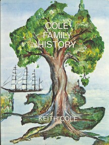 Bendigo Historical Society Inc.
Book - COLE FAMILY HISTORY, 1979
Cole family history, including the families of Cole, Brookes,Descor, Goodwin, Gough, Hume, Johnston, Pretty, Maiden, Newell, Shipley, Truscott. Published by Keith Cole publications, 96 pages with photographs and maps.Keith Colegenealogy, cole family, keith cole, cole family, brookes, descor, goodwin, gough, hume, johnston, pretty, maiden, newell, shipley, truscott. -
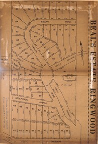 Ringwood and District Historical Society
Document - Folder, Beale's Estate Subdivision, Ringwood, Victoria - circa 1960
Manilla folder containing two undated maps of Beale's Estate subdivision 20559 showing allotments on Evelyn Road, Burlock Road (later Burlock Avenue), Adolphson Avenue, and Felix Crescent, North Ringwood. -
 Bendigo Historical Society Inc.
Newspaper - NEWSPAPER COLLECTION: THE BENDIGO MINER
Article from the Bendigo Miner of Thursday, December 13, 2007, by Jim Evans in the series ''History Lives'' titled Mapping it out. Also attached a colour copy of a mining map of the Sandhurst goldfield in 1873.newspaper, bendigo, bendigo miner -
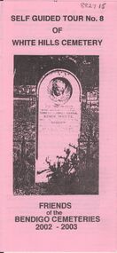 Bendigo Historical Society Inc.
Document - BENDIGO CEMETERIES COLLECTION: SELF GUIDED TOUR NO. 8 DOCUMENT
BHS CollectionPink document trifold. Self Guided Tour No. 8 of White Hills Cemetery, Friends of the Bendigo Cemeteries 2002 - 2003. Theme of tour 'Symbolism in White Hills Cemetery' Map with numbered grave sites.Friends of Bendigo Cemeteries 2002bendigo, cemetery, white hills cemetery tour -
Lakes Entrance Historical Society
Book, Jones Rebecca, An Ideal Excursion: A Recreation History of the Gippsland Lakes and its Guesthouses, 1880-1930, 1994
A history of guest houses and recreational pursuits of person holidaying in the gippsland lakes hinterland written as a thesis for a student during a master of arts degree sketch maps are used for location purposes photographs (photocopy) illustrations.guesthouses, settlers, tourism -
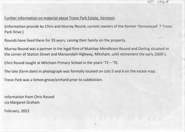 Whitehorse Historical Society Inc.
Document - Real estate notes, maps, flyers, Trove Park Estate, 1969, 2022
A history of the Trove Park Estate, Vermont from 1880's to 2022 is provided by notes, maps, pictures and auction flyers. The Estate was originally part of the Uplands Estate of 34 acres in the Mount Pleasant district.A history of the Trove Park Estate, Vermont from 1880's to 2022 is provided by notes, maps, pictures and auction flyers. The Estate was originally part of the Uplands Estate of 34 acres in the Mount Pleasant district.A history of the Trove Park Estate, Vermont from 1880's to 2022 is provided by notes, maps, pictures and auction flyers. The Estate was originally part of the Uplands Estate of 34 acres in the Mount Pleasant district.trove park drive estate vermont, mt pleasant, trove park, uplands vermont, bishop edward, round chris & murray, mulcahy mendelson & round, trove park drive vermont no 7