Showing 815 items matching " aerial views"
-
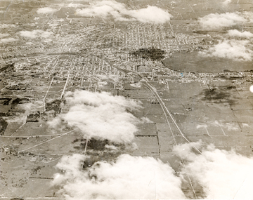 Ballaarat Mechanics' Institute (BMI Ballarat)
Print - Photograph by Herb Richmond. ca 1971, Ballarat aerial view
... Ballarat aerial view... matte print Ballarat aerial view Print Photograph by Herb ...Ballarat HistoryOld matte printballarat, ballaraat, aerial -
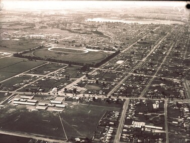 Ballaarat Mechanics' Institute (BMI Ballarat)
Aerial View
... Aerial View... Aerial View ...This photograph is from the Max Harris Collection held by the Ballaraat Mechanics' Institute. Please contact BMI for all print and usage inquiries.ballarat, aerial, 1960s -
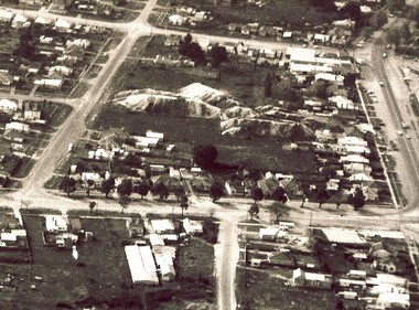 Ballaarat Mechanics' Institute (BMI Ballarat)
Aerial View Guiding Court vicinity
... Aerial View Guiding Court vicinity... Aerial View Guiding Court vicinity ...This photograph is from the Max Harris Collection held by the Ballaraat Mechanics' Institute. Please contact BMI for all print and usage inquiries. ballarat, aerial, 1960s -
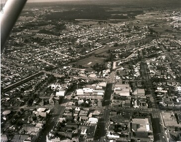 Ballaarat Mechanics' Institute (BMI Ballarat)
Aerial View Ballarat Southern CBD
... Aerial View Ballarat Southern CBD... Aerial View Ballarat Southern CBD ...This photograph is from the Max Harris Collection held by the Ballaraat Mechanics' Institute. Please contact BMI for all print and usage inquiries.ballarat, aerial, 1960s -
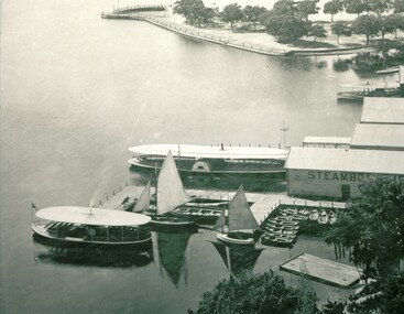 Ballaarat Mechanics' Institute (BMI Ballarat)
Aerial view lake and steamers
... Aerial view lake and steamers... aerial steamers Aerial view lake and steamers ...This photograph is from the Max Harris Collection held by the Ballaraat Mechanics' Institute. Please contact BMI for all print and usage inquiries.ballarat, lake wendouree, aerial, steamers -
 Port Melbourne Historical & Preservation Society
Photograph - Aerial view of 3 liners at Station Pier, Port Melbourne, 14 Feb 2001
... Aerial view of 3 liners at Station Pier, Port Melbourne.... COPYRIGHT RESTRICTED Photograph Aerial view of 3 liners at Station ...Large colour aerial photograph of 3 liners at Station Pier. Siver Cloud - outer East; QE2 - outer West; Regal Princess - inner West. View of Port Melbourne housing and foreshore development. Women's Welcome (or band) Rotunda on left of photo. Also a newspaper copy of the photo. COPYRIGHT RESTRICTEDmaritime, piers and wharves - station pier, transport - shipping, queen elizabeth ii, regal princess, silver cloud, beacon cove, swallow & ariell ltd, band rotunda -
Port Melbourne Historical & Preservation Society
Photograph - Aerial view of Yarra River and surrounds, 1990s
... Aerial view of Yarra River and surrounds... skyline. Taken mid 1990s Photograph Aerial view of Yarra River ...COPYRIGHT THE AGE Aerial photograph showing the Yarra River, Webb Dock, Port Melbourne beach, Princes pier, West Gate Bridge, Maribyrnong River, Swanston Dock and Melbourne City skyline. Taken mid 1990sStamped "Copyright. This photograph may not be reproduced without permission in writing from the Photo sales department of "the Age"'built environment - commercial, engineering - bridges, fishermans bend, natural environment - beaches and foreshore, piers and wharves - princes pier, piers and wharves - webb dock, transport - shipping, yarra river, west gate bridge, sandridge beach, maribyrnong river, swanston dock -
Port Melbourne Historical & Preservation Society
Photograph - Aerial view of Station Pier, Port Melbourne on completion, Port Melbourne, 1930
... Aerial view of Station Pier, Port Melbourne on completion... Aerial view of Station Pier, Port Melbourne on completion, Port ...Aerial photo of Station Pier on completion, 1930. Three colliers 'laid up' on east side and Weeroona (east) and Hygeia (west) laying at the wing piers. Shows the area set aside for Centenary Bridge.centenary bridge, melbourne harbor trust - port of melbourne authority, piers and wharves - station pier, transport - shipping, engineering - bridges, dumosa - collier, werribee - collier, ashridge - collier, ps weeroona, ps hygeia, transport - ferries -
Port Melbourne Historical & Preservation Society
Photograph - Aerial view of J Kitchen & Sons site, Ingles Street, Port Melbourne, 1930
... Aerial view of J Kitchen & Sons site, Ingles Street, Port... with Football ground at rear Photograph Aerial view of J Kitchen & Sons ...Overhead -aerial - photo of J Kitchen & Sons factories with Football ground at rearsport - australian rules football, sport - cricket, industry, j kitchen & sons pty ltd -
Port Melbourne Historical & Preservation Society
Photograph - Aerial view of J Kitchen & Sons site, Port Melbourne, 1945
... Aerial view of J Kitchen & Sons site, Port Melbourne... in the background. Photo taken approx 1945 (copy) Photograph Aerial view ...Large black and white aerial photo in narrow gold-coloured metal frame of J Kitchen & Sons Pty Ltd factory in foreground and Dunlop Tyres building in the background. Photo taken approx 1945 (copy)industry - manufacturing, built environment - industrial, j kitchen & sons pty ltd, pental products pty ltd, symex holdings ltd -
Port Melbourne Historical & Preservation Society
Photograph - Aerial view of Port Melbourne, overlaid, Charter Keck, Cramer, Nov 2006
... Aerial view of Port Melbourne, overlaid... Aerial view of Port Melbourne, overlaid Charter Keck, Cramer ...Black and White aerial photo with red map overlay, labelled "Port Melbourne 1946 overlaid" in gold/brown metal frame . Shows Yarra River, Coode Canal and Hobson's Bay.built environment - industrial, engineering - canals and drainage, coode island, yarra river, melbourne harbor trust - port of melbourne authority -
Port Melbourne Historical & Preservation Society
Photograph - Aerial view of HMS Hood, Port Phillip Bay, Royal Australian Air Force (RAAF), 1924
... Aerial view of HMS Hood, Port Phillip Bay... Hood coming up the bay Photograph Aerial view of HMS Hood, Port ...Air Force aerial photos of the visit of HMS Hood and HMS Repulse 1924 01 - HMS Hood coming up the baypiers and wharves - princes pier, transport - shipping, armed services - navy, hms hood, hms repulse, ss james patterson -
Port Melbourne Historical & Preservation Society
Photograph - Aerial view of HMS Repulse with tug James Patterson passing Williamstown, Royal Australian Air Force (RAAF), 1924
... Aerial view of HMS Repulse with tug James Patterson passing... Photograph Aerial view of HMS Repulse with tug James Patterson ...Air Force aerial photos of the visit of HMS Hood and HMS Repulse 1924 02 - HMS Repulse passing Williamstown with the tug James Pattersonpiers and wharves - princes pier, transport - shipping, armed services - navy, hms hood, hms repulse, ss james patterson -
Port Melbourne Historical & Preservation Society
Photograph - Aerial view of HMS Repulse being berthed at outer west Princes Pier by tug James Patterson, Port Melbourne, Royal Australian Air Force (RAAF), 1924
... Aerial view of HMS Repulse being berthed at outer west... Patterson. New beacons are visible Photograph Aerial view of HMS ...Air Force aerial photos of the visit of HMS Hood and HMS Repulse 1924 04 - HMS Repulse being berthed at Outer West Princes Pier by tug James Patterson. New beacons are visiblepiers and wharves - princes pier, transport - shipping, armed services - navy, hms hood, hms repulse, ss james patterson -
Port Melbourne Historical & Preservation Society
Photograph - Aerial view of J Kitchen and Sons site, Ingles Street, Port Melbourne, early 1930s, 1930s
... Aerial view of J Kitchen and Sons site, Ingles Street, Port... in the distance. Taken in the early 1930s Photograph Aerial view of J ...Large Black and White aerial photograph on brown cardboard showing Kitchen and Sons buildings including the 1925 Administrative Building No 34 on Ingles st.Photograph taken looking North Easterly with Swanston and Barret Pty concrete works; Port Melbourne Football ground in foreground; Yarra River in top left hand corner; showing South Melbourne and Royal Botanic Gardens in the distance. Taken in the early 1930sindustry - manufacturing, built environment - industrial, j kitchen & sons pty ltd -
Port Melbourne Historical & Preservation Society
Photograph - Aerial view over Yarra River and Port Melbourne, 18 Jun 1940
... Aerial view over Yarra River and Port Melbourne.... Photograph Aerial view over Yarra River and Port Melbourne ...Aerial photograph overlooking the Yarra River with Port Melbourne in the middle. Background - Williamstown Road is visible at the top of the picture.piers and wharves - miscellaneous, built environment - commercial, malcolm moore ltd, north wharf, south wharf, nordfest -
Port Melbourne Historical & Preservation Society
Photograph - Aerial view of Port Melbourne, 1931
... Aerial view of Port Melbourne... to Bridge Street and Lagoon to Bay Street Photograph Aerial view ...Section of aerial photograph of Port Melbourne c1931 (refer item 574), covering Beach almost to Bridge Street and Lagoon to Bay Streetsandridge lagoon, built environment -
Port Melbourne Historical & Preservation Society
Photograph - Aerial view of Port Melbourne, 1931
... Aerial view of Port Melbourne... Street and Lagoon to Lyons Street Photograph Aerial view of Port ...Section of aerial photograph of Port Melbourne c1931 (refer item 574), covering Beach to Spring Street and Lagoon to Lyons Streetsandridge lagoon, built environment -
 Port Melbourne Historical & Preservation Society
Photograph - Aerial view Beacon Cove area during soil cleaning operation, 1990
... Aerial view Beacon Cove area during soil cleaning operation.... Photograph Aerial view Beacon Cove area during soil cleaning ...Framed colour aerial photograph of the Beacon Cove area during the soil cleaning operation prior to building the project. Area covered: from Beacon Road to Bain Street, and from the beach to the rear beacon. Foot of Princes Pier also shown.environmental issues -
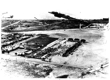
Port Melbourne Historical & Preservation Society
Photograph - Aerial view, Fishermans Bend, C D Pratt, 1945
... Aerial view, Fishermans Bend... and three significant tears Photograph Aerial view, Fishermans Bend ...Aerial photograph c1945 with the City of Melbourne in the foreground, showing Fishermen's Bend. Nissen huts are visible on the beach, as is one of the airfields. Fragment of photograph missing from bottom left hand corner and three significant tearsfishermans bend, war - world war ii, melbourne -
Port Melbourne Historical & Preservation Society
Photograph - Aerial view of cruise ships at Port Melbourne piers, 13 Feb 2001
... Aerial view of cruise ships at Port Melbourne piers... and Ariell, also Stokes and Princes Streets Photograph Aerial view ...This photograph records the concurrent visit to Station Pier of three cruise ships - the peak of the Cruising Victoria strategy aimed at encouraging cruise shipping to Melbourne. Also the Devil Cat was berthed at Station Pier on this day but not in the photo (4 ships in one day)Aerial colour photograph taken by The Age, showing from left to right, cruise ships Regal Princess, QE2 and Silver Cloud, all at Station Pier on 13 February 2001. An unusual persective showing the rear of 'The Anchorage', formerly Swallow and Ariell, also Stokes and Princes Streetspiers and wharves - station pier, transport - shipping, rms queen elizabeth 2, qe2, swallow & ariell ltd, regal princess, silver cloud -
Port Melbourne Historical & Preservation Society
Photograph - Aerial view showing route of Lower Yarra Crossing Project (West Gate Bridge), Apr 1966
... Aerial view showing route of Lower Yarra Crossing Project... Photograph Aerial view showing route of Lower Yarra Crossing Project ...Black and white aerial photomap showing the proposed route of the Lower Yarra Crossing Project, later to become the West Gate Bridge and Freeway. April 1966'Lower Yarra Crossing Project' '296769'west gate bridge, transport - roads, engineering - bridges -
Port Melbourne Historical & Preservation Society
Photograph - Aerial view of (finally) in-filled Lagoon, Port Melbourne, 1931
... Aerial view of (finally) in-filled Lagoon, Port Melbourne... Street Photograph Aerial view of (finally) in-filled Lagoon, Port ...Image seems to be one of several aerial shots around 1931, possibly all shot from one flight. Aerial photo of Port Melbourne c1931 showing clearly the finally filled Lagoon, and central area from Gasworks to past Bay Street, from Town Hall to Town Pier. Cable tram cars can be seen on Bay Streetsandridge lagoon, built environment -
Port Melbourne Historical & Preservation Society
Photograph - Aerial view of Port Melbourne, circa 1928
... Aerial view of Port Melbourne... Aerial view of Port Melbourne ...Aerial photo of Port Melbourne c1928 focusing on the Gas Works area spanning Port Melbourne and Albert Park. Shows the finally filled Lagoon, and area from the Harpers Starch factory to Foote St, Albert Park and from the bay to just over Richardson/Liardet Stssandridge lagoon, built environment - industrial, industry, gasworks, joshua brothers distillery, harpers starch factory -
Port Melbourne Historical & Preservation Society
Photograph - Aerial view of four US ships at princes Pier, Port Melbourne, Airsky, Aug 1925
... Aerial view of four US ships at princes Pier, Port... grandmother Euralee's death in December 2001 Photograph Aerial view ...After death of Euralee, the original was found among her papers, mounted on brown cardboard'sepia' lasercopy from 1925 aerial photograph of four US ships at Princes Pier in August 1925, found by Clark Towson after his grandmother Euralee's death in December 2001original had the four ships names at Princes Pier, Port Melbourne, August 1925.piers and wharves - princes pier, uss oklahoma, uss seattle, uss nevada, uss pennsylvania -
 Port Melbourne Historical & Preservation Society
Photograph - Aerial view of first Bank Houses in Garden City, 1927
... Aerial view of first Bank Houses in Garden City...) Photograph Aerial view of first Bank Houses in Garden City ...Photographic copies from black and white aerial photograph of the building of the first State Savings Bank Houses in Garden City 1927, showing also Graham Street State School, Princes Pier, Graham Street and Williamstown Road, west wing of Station Pier ("Rotomahana" at pier)built environment - domestic, fishermans bend, garden city, education - primary schools, melbourne harbor trust - port of melbourne authority, state savings bank of victoria, graham street state school, port melbourne primary school, bank houses -
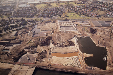
Port Melbourne Historical & Preservation Society
Photograph - Aerial view of land reclamation at Webb Dock, Port Melbourne, 1997
... Aerial view of land reclamation at Webb Dock, Port..., 1997 Photograph Aerial view of land reclamation at Webb Dock ...Colour aerial photo showing land reclamatioon at Webb Dock, 1997piers and wharves - webb dock, melbourne harbor trust - port of melbourne authority -
Port Melbourne Historical & Preservation Society
Photograph - Aerial view of Port Melbourne piers and foreshore, Jack GOULD
... Aerial view of Port Melbourne piers and foreshore..... Photograph Aerial view of Port Melbourne piers and foreshore. Jack ...From a box of photographs in Nancy U'REN's papers used during research for her thesis, The Early Growth and Development of Sandridge (1976) and/or her book with Noel TURNBULL, A History of Port Melbourne (1983). Jack GOULD probably created this from an earlier photograph.Black and white aerial photograph showing the Port Melbourne foreshore and the piers from Princes Pier to Lagoon Pier and beyond. C. 1922-23.piers and wharves - princes pier, piers and wharves - town pier, piers and wharves - lagoon pier, foreshore, piers and wharves - railway pier, nancy u'ren nee morris -
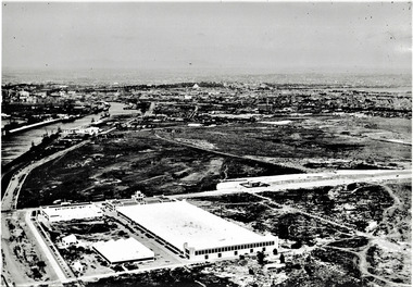 Port Melbourne Historical & Preservation Society
Photograph - Aerial view of Fisherman's Bend circa 1940, circa1940
... Aerial view of Fisherman's Bend circa 1940.... & South Wharves. Photograph Aerial view of Fisherman's Bend circa ...From the collection of Terry KEENAN. The 9 hole golf course known as the Sandridge Golf Club was part of Victorian Golf Clubs until it moved to Cheltenham in 1927. Trotting 'Speedway' located at top right of photograph.Black and white photograph of Fishermans Bend, Port Melbourne, c. 1940 showing General Motors Holden in the foreground. The original home of the Victoria Golf Club is shown on the left beside the Yarra River winding towards the city & North & South Wharves. built environment, fishermans bend, built environment - industrial, general motors-holden, victoria golf club, sport - golf, sport - horse racing -
Port Melbourne Historical & Preservation Society
Photograph - Aerial view of Port Melbourne, c. 1990
... Aerial view of Port Melbourne... (recollections only). Photograph Aerial view of Port Melbourne ...Notations made as a result of conversations Anne had in the early 1990's with an elderly male resident of Port Melbourne.Map and aerial photo of Port Melbourne with handwritten annotations detailing the location of various buildings, trotting tracks, etc which previously existed in Port Melbourne (recollections only).fishermans bend