Showing 1946 items matching " flooding"
-
 Kew Historical Society Inc
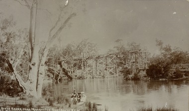
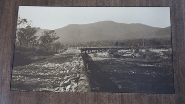
Postcard, River Yarra near Macauleys' Boathouse Kew
Sepia postcard of the Zig-zaf Bridge joining Yarra Bend and Studley Park. In the foreground is a rowboat in which a man is standing, behind whom are two women in hats and a young child. The man appears to be pushing the boat away from the Bank. In the distance is the wooden Zig-Zag Bridge, constructed in the 1870s to link the Yarra Bend and Kew Lunatic Asylums. [Destroyed by flood, 1929.]Obverse: "River Yarra near Macauleys' Boathouse Kew". Reverse: "Zig Zag Bridge / Gift from L Bennett 1980 / Bridge between Old Asylum & new Mental Hosp. / Kew side"zig-zag bridge -- kew (vic.), bridges -- river yarra, bridges -- kew (vic.) -
 Bendigo Historical Society Inc.
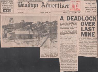
Newspaper - LYDIA CHANCELLOR COLLECTION: A DEADLOCK OVER LAST MINE
A Bendigo Advertiser article titled 'A Deadlock Over Last Mine.' The Wattle Gully goldmine at Chewton may close due to an impasse between the Mines Department and the management of the Wattle Gully mine. The issue of flooding of the 382 metre shaft wasn't being addressed according to the mine manager. A photo of the Wattle Gully goldmine is included in the newspaper article. 08/07/1977.mine, gold, wattle gully, lydia chancellor collection, collection, mining, chewton, wattle gully goldmine, goldmine -
 Eltham District Historical Society Inc
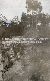
Photograph, Flood at Eltham, c.1924
Probably the 1924 flood which damaged the Main Road Bridge Pages from a scrapbook belonging to Heather Jenkins (nee Sargeant) who lived as a child in the Police Residence at 728 Main Road, Eltham in the 1920s.Heather Sargeant was the daughter of Constable W.C. Sargeant, the local police officer in residence at Eltham, 1922-1927Glued on a brown paper scrapbook page (torn from scrapbook) with 8 black and white/sepia photos of varying sizes, 1 newspaper clipping and one greeting card with printed sketch and handwritten captions in ink. On back of page is 1 black and white photo and a large newspaper clipping.eltham, police residence, heather jenkins (nee sargeant), walter withers, constable w.c. sargeant, floods -
 Stawell Historical Society Inc
Photograph, Greens Creek Bridge on the Wimmera River 1929
Greens Creek Bridge on the Wimmera River built in 1929 by C.R.B. and now demolished. The replacement bridge was designed to cope with the floods and the approaches to the new bridge were built up. This photo is a copy of a negative owned by the society.Black and white photograph of a concrete road bridge over a creek. Red gum trees in the background. Two concrete supports remain of old bridge on bank behind new bridge.stawell -
 Lakes Entrance Historical Society
Photograph - Costick's Weir, 1999
Built 1942 - 43 to ensure as adequate water supply for fire fighting purposes, after the devastation of the 1939 forest fires. Used by locals as a swimming pool until flooding in the 1980's filled the weir with silt.Colour photograph of Costicks Weir, Old Colquhoun Road, Colquhoun Forest. Shows manmade dam in bush setting. Constructed by building a weir wall across a small natural gorge. Nowa Nowa Victoriavegetation, weir's, local history -
 Lakes Entrance Historical Society
Photograph - Swan Reach Bridge, 1/12/2027 12:00:00 AM
The temporary bridge was in use until for four years, following the collapse of the permanent bascule bridge on 17 November 1925 due to attack by teredo worm. The temporary bridge was swept away during a flood in June 1930.Sepia toned photograph of a pontoon bridge over the Tambo River at Swan Reach Victoria, built as a temporary crossing after the collapse of the bascule bridge on 17 November 1925. Tambo River Christmas 1927 on reversereligion, buildings -
 Kiewa Valley Historical Society
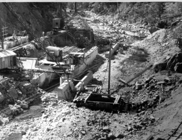
Photograph of Clover Dam foundations, Clover Dam Foundations, 1949
Stripping of the foundations commenced in 1948 and the first concrete in the dam was poured in May, 1949. With the suspension for the winter months of work on the High Plains, it was possible to increase the number of men, and work then proceeded at a steady pace for the remainder of the year. Some interruption was caused by a flood in September, which over topped the rockfill coffer dam. By the end of 1950 17,000 yards of material had been excavated from the foundations and 4,000 cubic yard of concrete placed. Work at Clover Dam was completed in 1953, but two bays were left open for flood emergency. The pondage was filled on the 16th August, 1954. A pictorial record of the placing of concrete foundations of Clover Dam and also shows the methods of construction used at this site in 1949.Black and white photograph taken during the construction of Clover Dam. Shows early stages of the concrete foundations, cranes and the railway line which was constructed to bring materials to the site. Handwritten in blue ink of back of photograph "Clover Dam Foundations"dam, foundations, concrete, construction -
 City of Greater Bendigo - Civic Collection
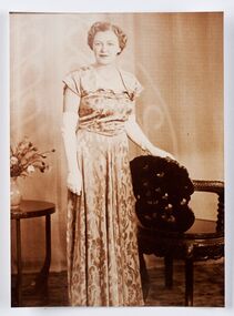
Photograph - Portrait, Monica Flood, Mayoress 1952 - 53, 1957 - 58, 1966 - 67, 1968 - 69, c 1950's
Prior to the election of female Councillors and Mayors in the 1960’s, the Lady Mayoress role was one of the few ways women could officially undertake civic duties. Mayoresses made important contributions to their local communities through their charity work and as ambassadors for their region on a state and federal level. They also undertook some Mayoral duties on occasions when their husband was unavailable. Monica Cecelia Murray was born in 1910 in Strathfieldsaye and married Thomas Flood in 1934. She served as Mayoress for four terms and died in 1973. Mayoress Flood was president of the St Mary's Past Pupul's Association and a patron of the Bendigo Girl Guildes. Reproduction of photographic studio portrait sitting behind oval mount.studio photography, raymond kelly, city of bendigo mayoress, city of greater bendigo portraits, city of bendigo mayor, mayoress flood, mayor t.r. flood -
 Mission to Seafarers Victoria
Letter - Correspondence, 03/04/1950
The writer refers to Allan's and her own family members and is thought to be a relative; more research is needed. She also writes ".....I suppose you've heard all about the floods here, winter certainly is settling in early ....".Quinn CollectionA single page of unlined pale blue paper folded in book form to give four pages of writing (0836.a). Letter is headed Nurses Home, Alfred Hospital, Prahran and dated 3.04.1950. Matching envelope (0836.b) is addressed to M.S. Mongabarra, C/- Elder Smith & Co., Adelaide. 'Adelaide' has been crossed out and an indecipherable port, possibly Port Lincoln, has been added by a different writer and in darker ink. Envelope bears three red, two and halfpenny Australian stamps franked Melbourne. The letter commences "Dear Allan......" and is signed "Yours June". letters-from-abroad, quinn -
 Victorian Interpretive Projects Inc.
Photograph - Colour, Clare Gervasoni, St Alipius Presbytery, Ballarat East, 07/01/2012
St Alipius Church was the first Catholic Church at Ballarat. It was initially a tent church in Humffray Street, but after flooding it was moved to Victoria Street were the current bluestone church was built. The presbytery is beside the church and houses the priests. A colour photograph in digital format showing red brick building with slate roof, behind a green iron fence. The building is St Alipius Presbytery, Victoria Street, Ballarat East. ballarat east, catholic, religion, church, st alipius', st alipius -
 Tatura Irrigation & Wartime Camps Museum
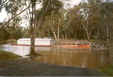
Photograph, Paddle Steamer "Arbuthnot", 1986
Paddle Steamer "Arbuthnot", purchased by the Shire of Rodney to be restored using unemployment relief funding. Located on Goulburn River, upstream of Shepparton. Photo taken 1986 during river flooding. Now restored at Echuca.|Rodney Shire -
 Bendigo Historical Society Inc.
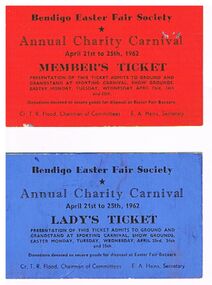
Document - DOCUMENT -BENDIGO EASTER FAIR SOCIETY TICKETS, 09/11/1903
Two Bendigo Easter Fair Society Annual Charity Carnival Tickets April 21st to 25th, 1962. The red one is a Member's Ticket and the blue one is a Lady's Ticket. Tickets admit bearer to ground and Grandstand at Sporting Carnival, Show Grounds on Easter Monday, Tuesday, Wednesday, April 23rd, 24th and 25th. Cr. T. R. Flood, Chairman of Committees and E. A. Hains, Secretary.bendigo, bendigo easter fair, charity carnival, document, bendigo easter fair society tickets, annual charity carnival, cr t r flood, e a hains -
 Kew Historical Society Inc
Photograph - Yarra River, Studley Park, 1924
Henry Beater Christian (1886-1962) , was a descendant of one of the earliest settler families in Kew. Employed at the Kew Asylum as a 'public servant', he was a skilled amateur photographer, photographing numerous scenes in Kew and on his travels around Victoria. The majority of his photographs date from 1916 to 1929. His finest photographs are housed in two photograph albums. Digital copy of a photograph from page 7 of the 47-page photograph album containing 261 gelatinous silver images, loaned by Diane Washfold with permission given to digitise and hold a copy in our collection. This photograph was taken during a flood year when the Yarra encroached on the grounds of the Abbotsford Convent. In the distance, the Johnston Street Bridge separates the viewer from the industrialised landscape of Fairfield."Studley Park / Kew"henry beater christian (1886-1962), landscape photography, kew (vic.) — yarra river, christian-washfold collection, photograph albums, fairfield, kew, johnston street bridge, studley park -
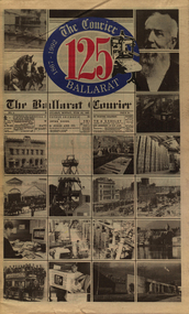 Federation University Historical Collection
Newspaper, Ballarat Courier, The Courier, Ballarat: 125 years, 10 June 1992
Celebration of 125 years of publication. Articles relate to things from the past. Articles published include: Pressmen of the 1800s; Edward Bateman; Ballarat's Bank; Water and floods; Surviving the Depression. Letter from The Premier of Victoria, Joan KirnerTabloid newspaperballarat courier, joan kirner, robert clark, lola montez, tom buryedward bateman, lake wendouree, floods, wills family -
Tatura Irrigation & Wartime Camps Museum
Photograph - copy, Collivers Milk Bar, 1950
Copy of photograph of Collivers mixed business and milk bar. Conducted from 1946 - 1986. Also bus depot for Bendigo to Shepparton bus, run by Floods for many years. Also sub agent for newspaper, magazines and Sunday papers.Black and white photograph of left hand side of shop, 159 Hogan Street, Tatura and part of dwelling. Old car in drive of yard, belongs to Browns, Bakers.on back: Collivers Milk Bar 1950 -
 Federation University Historical Collection
Photograph - Colour, Chatham-Holmes Collection: Outback Tour, 2003, 2003
Tour to outback regions of Australia - Innamincka and Cameron Corner. This is where the Queensland, New South Wales and South Australia borders meet. Photos show the floods, dryness of the land and the regeneration of plant life. Elizabeth Chatham is with family memberschatham-holmes collection, elizabeth chatham, outback, cameron corner, innamincka, queensland, new south wales, south australia, floods, desert plants -
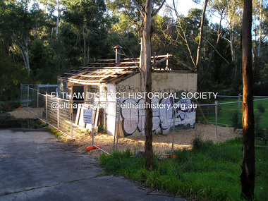 Eltham District Historical Society Inc
Photograph, Fay Bridge, Warrandyte cool store, 9 September 2019
Remains of the old Warrandyte Dairy — Originally constructed to store milk for delivery from Mapleoak Dairies, delivered by the Bellinger family, up until the early 1970s. The Warrandyte Dairy closed in 1987 before the land and building was purchased by Melbourne Water in 1988 to reduce flood risk to the community and preserve riverside land from development on the site which sits on the Yarra River flood plain. In 2017, through a partnership with Manningham City Council, Warrandyte Historical Society and the Warrandyte Community Association, Melbourne Water renovated the 73-year-old site and installed interpretive signs detailing its history for the community.2019-09-09, fay bridge collection, warrandyte cool store, warrandyte dairy -
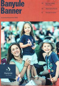 Greensborough Historical Society
Magazine, Banyule Banner November/December 2022, 2022_11
The Banyule Banner is published bi-monthly by Banyule City Council to advertise upcoming events in the City of Banyule and to report on past events. This edition contains reports on the aftermath of floods, bike paths in Banyule, and a roundup of significant events in Banyule in 2022,A record of events within the City of Banyule.24 pages, colour illustrations. banyule banner, banyule council -
 Greensborough Historical Society
Photographs, Jasmin Burge, Photography by Jasmin R. Burge, 2000-2012
Photographs of Greensborough and surrounds in the 21st century. Themes include Christmas Day 2012 floods, Loyola College, Greensborough Cemetery, Bill Cecil and Greensborough Historical Society. The photos have been distributed by theme throughout the Society's Digital Library.Modern Greensborough photographed by local photographer.CD containing a selection of photography by Jasmin BurgeWritten on label on CD: "Greensborough Historical Society. Photography by Jasmin R. Burge (J.R.Burge)"jasmin burge, greensborough, photographs, christmas day 2012 floods, loyola college, greensborough cemetery, bill cecil, greensborough historical society -
 Eltham District Historical Society Inc
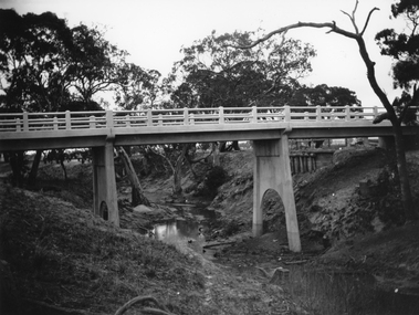
Photograph, Main Road Bridge, Eltham, c.1924
The wooden Main Road Bridge was substantially damaged in the 1924 flood and was replaced with a concrete structure Pages from a scrapbook belonging to Heather Jenkins (nee Sargeant) who lived as a child in the Police Residence at 728 Main Road, Eltham in the 1920s.This photo shows the flood damage to the bridge structure or the dismantling of the bridge post 1924 flood. Heather Sargeant was the daughter of Constable W.C. Sargeant, the local police officer in residence at Eltham, 1922-1927Glued on a brown paper scrapbook page (torn from scrapbook) with 9 black and white/sepia photos of varying sizes, 1 newspaper clipping and handwritten captions in ink.On verso in pencil "Const. W.C. Sargeant 1922-1927 - see Police list"heather jenkins (nee sargeant), eltham, police residence, constable w.c. sargeant, main road, main road bridge -
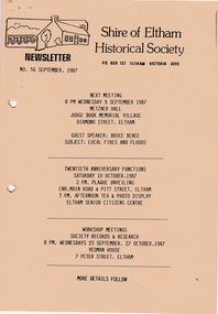 Eltham District Historical Society Inc
Newsletter, Newsletter, No. 56 September 1987
Contents: • Next meeting, guest speaker; Bruce Bence: Local fires and floods • September Meeting • Twentieth Anniversary Functions • Eltham Community Festival • Bronze Sculpture Project • Australian Bicentenary 1988 • Recent Activities • Other Brief Items The Shire of Eltham Historical Society was formed in October 1967. The first newsletter of the Society was issued May 1978 and has been published continuously ever since on a bi-monthly basis. With the cessation of the Shire of Eltham in late 1994, the Society's name was revised to Eltham District Historical Society and this name first appeared with issue No. 103, July 1995. The collection of the Society's newsletters provides a valuable resource on the history of the Society's activities, office bearers and committee members, guest speakers and subjects of historical interest pertinent to the former Shire of Eltham and the Eltham District.A4 photocopied newsletter distributed to membersnewsletter, eltham district historical society, shire of eltham historical society -
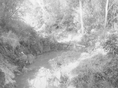 Ringwood and District Historical Society
Photograph, Mullum Creek. Taken from footbridge at end of Adelaide St, Ringwood. Aug. 1973
See also 2983Backing sheet on two copies reads, "Mullum Creek, Aug. 1963. Taken from footbridge at end of Adelaide St." Other copy reads, "Same area of flooded Mullum Creek as photo 403. A week later 1963".(Photo 403 is RE34 in Record 2983) -
Melbourne Tram Museum
Newspaper, The Herald, "Jail protesters paint trams", 23/02/1972 12:00:00 AM
Newspaper clipping titled - “Jail protesters paint trams” The Herald, Wednesday, Feb 23, 1972 Photos and text of vandalised trams at Preston workshops 20 trams, 40 men worked for an hour to remove the signs - graffiti - . Tram services not affected. Most of the trams were at Preston for repair after flood damage last week. See TMSV Running Journal April 1972 for details of the event.trams, tramways, preston workshops, graffiti, pentridge prison, protest -
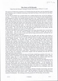 Bendigo Historical Society Inc.
Document - ELDORADO - THE STORY OF EL DORADO
Typed notes titled 'The Story of El Dorado' taken from the Mining & Geological Journal, dated January 1938 by D. G. Swift. Notes typed by L. G. Schilling, 13/10/69. Notes mention the disappointments, difficulties with water and the ground and floods, As well as gold they also found large quantities of tin oxide and a large variety of gemstones. A powerful jet of water was used for the mining.document, gold, eldorado, eldorado, the story of el dorado, mining & geological journal january 1938, d g swift, the argus 19/10/1855, kneebone & company, wellington party, mcevoy mine, kneebone mine, tin oxide, gemstones, united eldorado company, mining registrar, ovens gold and tin mining, eldorado extended, perserverance, great extended gold and tin mining, wellington company, mr william dunstan, united ovens gold and tin, the warrior, try again company, mcevoy disaster, cock's pioneer electric gold and tin sluicing company, mr h falsoner, cock's pioneer gold and tin mines n l company, state electricity commission, hydraulic sluicing, gold dredge, cock's eldorado company, l g schilling -
Tatura Irrigation & Wartime Camps Museum
CD, James Lally, Recollections of Tatura - Lally
Collection of photographs taken by Dr Desmond Lally and recorded onto CD by James Lally (son). Collection includes coronation procession 1953, Queen's visit 1954, floods 1956, old Tatura golf club 1964, Hill Top 1967.CD in a clear plastic rectangle cover. Black text on a silver disc. Contents of CD written on a piece of Verbatim Paper.local history -
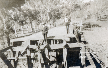
 Eltham District Historical Society Inc
Negative - Photograph, Construction of the new concrete bridge over the Diamond Creek on Main Road, Eltham, c.May 1926
Construction of the new concrete bridge over the Diamond Creek on Main Road, Eltham, c.May 1926. Viewed from northern approach looking south east towards Eltham Park (Eltham Lower Park), showing the power lines that used to run in front of the park. The original long suspension bridge over the Diamond Creek on Main Road at Eltham collapsed during flooding of the Diamond Creek on October 13 and 14, 1923. The original bridge was built around 1840 for the coach road when Cobb & Co.'s coach was the only conveyance between Eltham and Melbourne. Widespread damage was done in Melbourne and surrounding areas by floods resulting from the overflow of the Yarra at many points along its banks. A temporary bridge rigged up was severely damaged by the flooding of the creek and was closed to vehicular traffic in April 1924. A new concrete bridge was constructed to replace it and by May 1926 all the concrete piles and abutments had been completed. The bridge was finally completed and opened for traffic in September 1926, almost three years after it initially collapsed.This photo forms part of a collection of photographs gathered by the Shire of Eltham for their centenary project book,"Pioneers and Painters: 100 years of the Shire of Eltham" by Alan Marshall (1971). The collection of over 500 images is held in partnership between Eltham District Historical Society and Yarra Plenty Regional Library (Eltham Library) and is now formally known as the 'The Shire of Eltham Pioneers Photograph Collection.' It is significant in being the first community sourced collection representing the places and people of the Shire's first one hundred years.Digital image 4 x 5 inch B&W Negshire of eltham pioneers photograph collection, bridge, bridge construction, cement mixer, diamond creek (creek), eltham, eltham lower park, eltham south, main road bridge -
 Wodonga & District Historical Society Inc
Album - Hume Reservoir Australia Album - View from the Victorian bank of the Murray River, May 1923
This set of photos is from a leather bound album bearing the inscription "HUME RESERVOIR AUSTRALIA" plus 'The Rt. Hon. L. C. M. S. Amery, P. C., M .P.' all inscribed in gold. It was presented to The Rt. Hon. L. C. M. S. Amery, P. C., M. P, Secretary of State for Dominion Affairs on the occasion of his visit to the Hume Reservoir on 2nd November 1927. This album is of local and national significance as it documents the planning and development of the Hume Reservoir up to 1927. It was the largest water reservoir in the British Empire. The album records the pioneering engineering work that went into its construction.DEPARTMENT OF PUBLIC WORKS, N.S.W. RIVER MURRAY WATERS SCHEME. HUME RESERVOIR. 12. View from the Victorian bank of the river showing in the foreground a levee bank along the New South Wales side of the river with connecting wings back to the higher ground, May 1923. The first stage in the construction of the Dam foundations was carried out inside the levee bank which was at a sufficient height to protect from floods the work going on inside. A length of 300 feet of the Dam was left at a low elevation to allow of the river flowing over it in the second stage of the operations and at the ends of the concrete was brought up above flood level. To divert the river, a Coffer Dam was built across the old bed above and below the Dam site and tying into the end of the concrete wall built inside the levee bank. This completely surrounded the remainder of the site of the Dam and south wing wall, including an area of 12½ acres.hume reservoir australia, river murray waters scheme, hume reservoir construction -
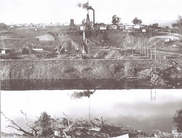
 Sunbury Family History and Heritage Society Inc.
Post Card, In and around Sunbury with Greeting
The post card is one of a set that were produced by Chris Christainsen, who had a pharmacy in Sunbury and was also a photographer. The four photos featured on the card are the Rupertswood Mansion, St Mary's Church of England, Jacksons Creek in floods ands Sunbury Railway station.The buildings and places featured on the card are of historical significance in the Sunbury town precinct. A post card with four sepia photographs of interesting sites which can be seen in the Sunbury township. IN AND AROUND SUNBURY WITH GREETING. christainsen, chris., rupertswood mansion, st. mary's church of england., jacksons creek, sunbury railway station -
 Kiewa Valley Historical Society
Photos - Tawonga Bridge x 2
The first Tawonga bridge was built in 1884. It was destroyed by floods in 1916. The new bridge was constructed in 1923 and destroyed in 1953. The present concrete bridge was constructed in 1986 and named Ryders Bridge. Also refer to ?KVHS 0962 and KVHS 1051, KVHS 1090, KVHS 1123Bridge constructed over the Kiewa River in 1923 and destroyed in 1953.1. Dark Brownish photo framed by thin wood. Photo shows bridge with mountain behind and river and river bank in the foreground. 2. Small photo showing 2 sides of the bridge - a close up view.tawonga bridge, kiewa valley, kiewa river -
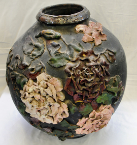 Orbost & District Historical Society
ginger jar, Pre 1893 floods in Orbost
In the early days of Orbost many Chinese were engaged in land clearing or had arrived when gold was discovered in East Gippsland in the 1840's. They lived in camps along the Marlo Road and houses were usually built on stilts. They left after the 1893 floods.This object has aesthetic appeal. It is an object which belonged to the very early settlement days of Orbost.Huge, ornate Chinese ginger jar. Four raised hand- painted pink roses on front. Jar itself is matt black. Looks more like a vase than a ginger jar. Ceramic.Some Chinese writing to left hand side of roses.ceramics, ginger jar, container - domestic, vase