Showing 1442 items matching " lithographers"
-
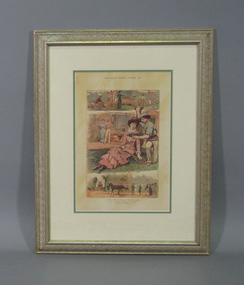 Tennis Australia
Page from Magazine, 1882
Page from The Graphic (Summer 1882 issue) featuring colour lithograph entitled 'OUR LAWN TENNIS' with three scenes subtitled '1. SACRIFICED TO TENNIS-2.VICTORY-3.THE DEPARTURE OF THE GUESTS'. Materials: Paper, Metal, Glass, Cardboard, Glue, Inktennis -
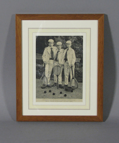 Tennis Australia
Page from book, Circa 1894
Page from book featuring lithograph of three boys with tennis racquets. Caption in German identifies sitters as the three eldest princes, sons of Kaiser Willhelm II, and specifies that the engraving was made from a photograph.. Materials: Paper, Ink, Metal, Wood, Glasstennis -
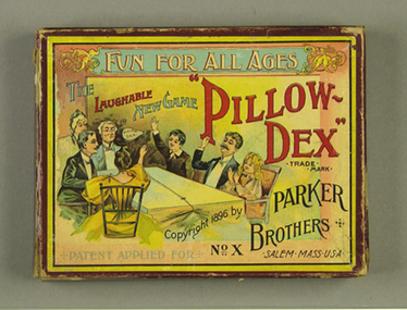 Tennis Australia
Action game, Circa 1896
'Pillow-dex' game set with coloured lithograph on cover. Contains two balloons, a thin rope divider weighted with wooden cubes, and an instruction sheet. Rules printed under lid. Appears complete. Materials: Cardboard, Ink, Rubber, Natural fibre, Woodtennis -
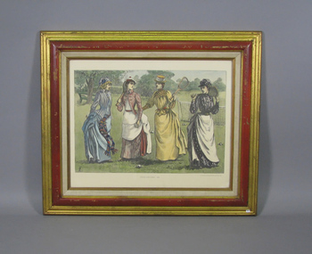 Tennis Australia
Print, 1888
Colour lithograph reproduction with caption 'TENNIS COSTUMES -1888'. Depicts four women with in tennis attire, three with racquets. A tennis net is visible behind them. Artist's initials 'LFE' in bottom left corner. Materials: Ink, Wood, Paper, Glass, Metaltennis -
 University of Melbourne, Burnley Campus Archives
Plan, Plan of Richmond Park, 1872
Plan of Richmond Park L4461. Shows Horticultural Society's Garden without extra land used for Field Station (see 11.0363, but earlier). Surveyed and drawn by A.L. Martin, Authorized Surveyor. Photo-lithographed at the Department of Lands and Survey, 6th Sept. 1872.Handwritten notes on reverse and another railway line marked in pencil.railway lines, swan street, yarra river, richmond park, horticultural society, orchard -
Federation University Historical Collection
Map, Creswick Gold Field Map, 1981
A fragment of the original 1880 map is also held in the collection. See 116Rectangular geological map with brown paper strip on top edge with 4 holes on top edge. Scale is 40 chains to one inch.Geologically and topographically surveyed by Ferdinand M Krause. Lithographed by R. Shepherd. Printed by J. Finnie. Mining Department, Melbourne. Preprinted with additional shaft and lead detail. F. D. Atkinson, Government Printer 1981creswick, krause, surveyor, smeaton, spring hill, tourello, ascot, dean, bullarook, gold fields, gold -
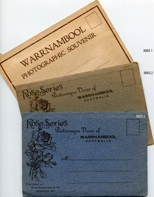 Flagstaff Hill Maritime Museum and Village
Postcard - Postcard Folder set, George Rose, Rose Stereographic Company, 1880-1942
Each postcard folder in this set has no address, message or postage stamp. Postcard folders such as these were popular as holiday souvenirs in the early to mid-20th century and were kept in good condition by collectors. The size is convenient for posting to friends and relatives and packing as holiday luggage. Postcards in the early-to-mid-19th century were an inexpensive way to remember and share holiday scenes, as few people could afford a camera and the price of developing the photographs. The images on these postcards were produced from black and white lithographs of photographs taken at Warrnambool and the surrounding district during the early to mid-20th century. Publishing firms such as Melbourne-based Valentine and Rose purchased photographs from local photographers and reproduced them for sale. This set of postcard folders shows that more than one publishing company had access to the same or almost the same images. The photographs include street scapes, the Warrnambool Breakwater and Pier, Botanical Gardens, beach scenes, cliff formations, the Hopkins River, municipal buildings, the Post Office and the Soldiers’ Memorial. The postcard folders in this set of three are significant as a record of local history from the late 19th century to the mid-20th century. The locations of the images match photographs and postcards in our collection that were taken at different times and provide a historical record of the Warrnambool and southwest Victorian locations, growth and changes.. The images record changes in the coastline, land, bay, buildings and other structures, roads, transportation and even the fashions of the times. Set of three postcard folders containing black and white images of photographed scenes showcasing Warrnambool and district between 1880 and 1942. The images were produced from lithographs of the original photographs and are printed on both sides of long strips of white photographic paper that are Z-folded into covers of textured card. Some of the images are repeated in all three folders. Folder 8665.1 - the cream-coloured folder was produced by The Valentine Publishing Co. Pty. Ltd. Melbourne and contains 15 photographs, some of which are also in the blue and the green folders. Folders 8665.2, the green folder, and 8665.3, the blue folder, were published by Rose Stereograph Co, Armadale, Vic. Each contains the same twelve images, but they are presented in a different order. flagstaff hill maritime museum and village, great ocean road, shipwreck coast, warrnambool, flagstaff hill, flagstaff hill maritime museum, flagstaff hill maritime village, warramble, postcard, postcard folder, warrnambool scenes, picturesque views of warrnambool, picturesque views of warramble, lady bay, port of warrnambool, breakwater, warrnambool breakwater, viaduct, merri river footbridge, merri river suspension bridge, suspension footbridge, merri river mouth, hopkins river mouth, proudfoot's, fanny nelson, nelson's boatsheds, nelson's boathouse, boathouse, hopkins river boathouses, flett's boathouse, flett, george rose, image of a rose, rose series, rose stereograph co, rose stereographic company, lighograph, armadale victoria, lady bay beach, beach scene, lower light, concrete footbridge, 1922 footbridge, viaduct road, rose postcard, new concrete bridge, 1945, 1890, 1922, small footbridge, 1872 footbridge, 1872, merri river estuary, stingray bay, postcards, shipwrecked coast, maritime museum, souvenir, warrnambool local scenes, hopkins river, botanic gardens, soldiers’ memorial, pier, post office, municipal buildings, merri river, proudfoot’s, the cliffs at shelly beach, the road to sandy beach, tourism, photographs, visitors, travel, scenes, local history, mid-20th century, 1940s, 1950s, rose stereograph co armadale. vic, valentine publishing co. pty. ltd melbourne, valentine publishing co. pty. ltd sydney -
Bendigo Historical Society Inc.
Map - LYELL : COUNTY OF BENDIGO, 24-10-84
Map. Lyell, County of Bendigo, Eppalock, Sedgwick, Sutton Grange, Hawkestone, Kimbolton, Coliban River, Myrtle Creek. State School. Photo-Lithographed at the Department of Lands and Survey, Melbourne by J. Noune, 24-10-84. (number 71 in map cupboard 1)J. Nounemap, bendigo, lyell -
Bendigo Historical Society Inc.
Map - LYELL : COUNTY OF BENDIGO, 24-9-07
Map. Lyell, County of Bendigo, Sedgwick, Sutton Grange, Hawkestone, Kimbolton, Eppalock, Myrtle Creek, Coliban River. Photo-Lithographed at the Department of Lands and Survey, Melbourne by T.F. McGauran, 24-9-07, Price 1/-. (number 70 in map cupboard 1)T.F. McGauranmap, bendigo, lyell -
Bendigo Historical Society Inc.
Map - LOCKWOOD : COUNTY OF BENDIGO, 2=7-18
Map. Lockwood, County of Bendigo. Marong, Shelbourne, Ravenswood, Mandurang. Photo- Lithographed at the Department of Lands and Survet, Melbourne by W.J. Butson 2-7-18. By authority A.J. Mullett, Government Printer, Melbourne. Price 1/-. (number 69 in map cupboard 1)A.J. Mullett, Government Printer, Melbourne.map, bendigo, lockwood -
Bendigo Historical Society Inc.
Map - LEICHARDT : COUNTY OF BENDIGO, 15-6-19
Map. Leichardt, County of Bendigo, Bridgewater, Yarraberb, Nerring, Marong, Woodstock, Derby, Sandhurst & Inglewood Railway Line. Photo-Lithographed at the Department of Lands and Survey, Melbourne, by T.F. McGauran, 15-6-09. Price 1/-. (number 68 in map cupboard 1)T.F. McGauranmap, bendigo, leichardt -
 Bendigo Historical Society Inc.
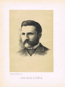
Photograph - JOHN QUICK LLD MLA
Sepia lithograph of John Quick. Image shows head and shoulders of male, wearing suit, cravat. Moustache, side beard. Written on bottom ' John Quick LLD. MLA.' in capital letters. Written on LH side bottom under print ' Fergusson & Mitchell. Lith'photo, individual, sir john quick -
Bendigo Historical Society Inc.
Map - YARRAYNE : COUNTY OF BENDIGO, 6-1-32
Map. Yarrayne, County of Bendigo, Janiember Easr, Pompapiel, Salisbury, Bridgewater, Salisbury West, Powlett. Photo-Lithographed at the Department of Lands and Survey, Melbourne. Price 2/-. 6-1-32.By authority H.J. Green, Govt.Printer. (number 31 in map cupboard 1)H.J. Green, Govt.Printer.map, bendigo, yarrayne -
Bendigo Historical Society Inc.
Map - WANURP : COUNTY OF BENDIGO, 1-12-33
Map. Wanurp, County of Bendigo, Terrick Terrick East, Pannoobamawm, Milloo, Dingee, Mitiamo. Photo-Lithographed at the Dept. of Lands and Survey, Melbourne. Price 1/-. 1-12-33. By authority H.J. Green, Govt. Printer. (number 26 in map cupboard 1)H.J. Green, Govt. Printermap, bendigo, wanurp -
Bendigo Historical Society Inc.
Map - CORNELLA : COUNTY OF BENDIGO, 18-3-08
Map. Cornella, County of Bendigo, County of Rodney, Colbinabbin, Gobarup, Redcastle, Toolleen, Cornella Creek, Kangaroo Creek. Photo-Lithographed at the Department of Lands and Survey, Melbourne by T.F. McGauran. 18-3-08. Price 1/-. (number 122 in map cupboard 1)T.F. McGauranmap, bendigo, cornella -
Bendigo Historical Society Inc.
Map - DERBY : COUNTY OF BENDIGO, 1-9-09
Map. Derby, County of Bendigo, Inglewood, Loddon River, Tarnagulla, Woodstock, Leichardt, Bridgewater, Bendigo to Inglewood Railway. Photo-Lithographed at the Department of Lands and Survey, Melbourne, by T.E. McGauran 1-9-09. Price 1/-. (number 55 in map cupboard 1)T.E. McGauranmap, bendigo, derby -
Bendigo Historical Society Inc.
Map - YARRABERB : COUNTY OF BENDIGO, 2-3-51
Map. Yarraberb, County of Bendigo, Salisbury, Yallook, Neilborough, Nerring, Leichardt, Bridgewater. L5373. By authority H.J. Green, Govt. Printer,Photo-Lithographed at the Deptartment of Lands and Survey, Melbourne. Price 2/-.2-3-51. (number 15 in map cupboard 1)H.J. Green, Govt. Printermap, bendigo, agricultural lands -
 Bendigo Historical Society Inc.
Map - MARKS COLLECTION: MAP SANDHURST 1867
Original map: Sandhurst 1867, shows central Bendigo and surrounds, including police camp, stockade, 'old cemetery', reserve for. On bottom of map: 'Lithographed at the Department of Lands and Survey by D. Henderson, 20 February, 1867'. On top RH corner 'Sheet No 1 Sandhurst'.map, bendigo, 1867 sandhurst map -
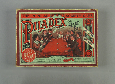 Tennis Australia
Action game, Circa 1897
'Piladex or Hand Ball' game set with coloured lithograph on cover. Contains two balloons, and a thin rope divider weighted with wooden cubes. Also contains an instructions/rules pamphlet. Set appears complete. Materials: Cardboard, Ink, Rubber, Natural fibre, Woodtennis -
Lakes Entrance Historical Society
Book, Gippsland Heritage Journal - issue 20, 1997
No 21 of a series contains articles on building materials around the Gippsland Lakes, Brown Coal Mine School, Rancby Church, Yarrams Regents Theatre, town of Moe, Mary Fullerton, Kingsford-Smith, Wonthaggi Leek Club. Also many photographs and lithograph obuilding industry, schools, religion, township -
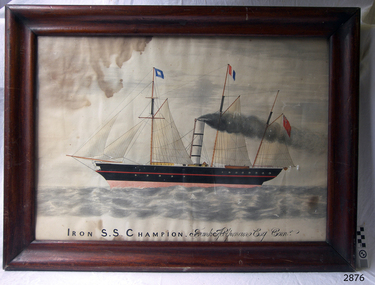 Flagstaff Hill Maritime Museum and Village
Painting - Lithograph, Iron S.S. Champion Frank Helpmann Esq. Comr, 1853 or later
Captain Benjamin Francis (Frank) Helpmann was once the owner of the S.S. CHAMPOIN, then owned it in partnership with S. G. Henty. S.S. CHAMPION was an early steamship and one of the first coastal traders to operate between Melbourne and Portland in Victoria from December 1853 until August 1857, when she collided with the S.S. LIRDY BIRD in the open sea off Cape Otway. CHAMPION was returning from Melbourne, and sank with thirty-two people still on board. The thirty others were saved by the LIRDY BIRD (ref. The Story of a Port : Portland, Victoria, by Noel F. Learmonth)This picture Lithograph) is associated with the S.S. Champion, which is listed on the Victorian Heritage Database VHR S110. The wreck of the SS Champion is significant historically as one of Victoria's worst shipwrecks. As an early steamship it played an important part in the development of and communications between the Western district and Melbourne . Although the site has not yet been located it is predicted to be highly significant archaeologically with the potential to yield information about early coastal shipping and the western district passenger and cargo trade. It is significant technically as an example of an early iron screw steamship, and is part of the western district steamship resource including the SS Casino, SS Coramba and SS Julia Percy.Painting. Lithograph of the schooner S S Champion, hand coloured watercolour, in a cedar frame behind glass. Unusual cross member bracing on the corners of the frame (one missing). Title "Iron S.S. Champion Frank Helpmann Esq. Comr" (in script) on bottom of picture.On the bottom of the painting "Iron S.S. Champion" (in printing), "Frank Helpmann Esq. Comr" (in script) shipwrecked coast, flagstaff hill, flagstaff hill maritime museum, maritime museum, shipwrecked artefact, flagstaff hill maritime village, shipwreck coast, warrnambool, lithograph, frank helpmann, henty -
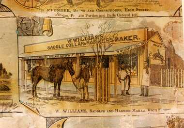 Charlton Golden Grains Museum Inc
Photograph - Lithograph, Charlton Tribune, Views of Charlton
W. Williams Saddlery, first shop established c. 1876 near Cricket Club Hotel, High St CharltonCopy from 1891 Lithograph. Sepia tones. W. Williams Saddle Collar & Harness Maker. Three men in front of shop; one holding a horse, two in aprons. Text at bottom of picture reads "W. Williams, Saddle & Harness Maker, High Street"Rider & Mincer Lithosw. williams, saddlery, lithograph, charlton -
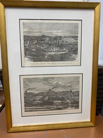 Clunes Museum
Print, R GROSSE
.1 TWO PRINTS, ONE ABOVE THE OTHER, COPIED TO BUFF COLOURED PAPER, MOUNTED IN GOLD COLOURED TIMBER FRAME. PRINTS TAKEN FROM LITHOGRAPHS .2 FRAMED COLOUR PRINT OF TOWNSHIP OF CLUNES APPROX 1890'S. SAME AS TOP IMAGE OF .1TOP IMAGE PRINTED IN BLACK: TOWN OF CLUNES - POPULATION 4874 NUMBER OF BUILDINGS 1100 GOLD FIRST DISCOVERED HERE Ist JULY 1851 BOTTOM IMAGE PRINTED IN BLACK: PORT PHILLIP AND COLONIAL GOLD MINING COMPANY CLUNESport phillip mine, township of clunes -
Bendigo Historical Society Inc.
Map - RAVENSWOOD, COUNTIES OF BENDIGO & TALBOT, 12-12-22
Map, Ravenswood, Counties of Bendigo & Talbot, Shelbourne, Walmer, Harcourt, Sutton Grange, Mandurang, Lockwood.By Authority A.J.Mullett, Govt. Printer, Melbourne. Photo-Lithographed at the Dept. of Lands and Survey, Melbourne by W.J.Butson 12-12-22, Price1/-. (number 87 in map cupboard 1)A.J.Mullett. Govt. Printer, Melbourne.map, bendigo, ravenswood -
Bendigo Historical Society Inc.
Map - PARISH OF STRATHFIELDSAYE : COUNTY OF BENDIGO, 1-10-19
Map. Parish of Strathfieldsaye, County of Bendigo, Wellsford, Sandhurst, Sedgwick, Eppalock, Axedale. Photo-Lithographed at the Department of Lands and Survey, Melbourne by W.J.Butson, 1-10-19. Price 1/-. By authority A.J. Mullett, Government Printer, Melbourne. (number 34 in map cupboard 1)A.J. Mullett, Govt. Printer, Melbourne.map, bendigo, strathfieldsaye -
Bendigo Historical Society Inc.
Map - SEDGWICK : COUNTY OF BENDIGO, 18-12-20
Map. Sedgwick, County of Bendigo,Strathfieldsaye, Mandurang, Sutton Grange, Lyell, Eppalock. Photo-Lithographed at the Department of Lands and Survey, Melbourne by W.j. Butson 18-12-20, Price 1/-. By authority A.J.Mullett, Government Printer, Melbourne. (number 29 in map cupboard 1)A.J. Mullett, Government Printer,Me;bourne.map, bendigo, sedgwick -
Bendigo Historical Society Inc.
Photograph - HARRY BIGGS COLLECTION: NEW ZEALAND/JAMES COOK
Photograph. Harry Biggs Collection. A small black & white photograph of a painting or lithograph of what may be Maori's in New Zealand with perhaps James Cook in the centre. A large building has been constructed & a building at the back that can only be partially seen have Maori characteristics.place, harry biggs collection, new zealand, maoris, james cook -
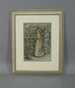
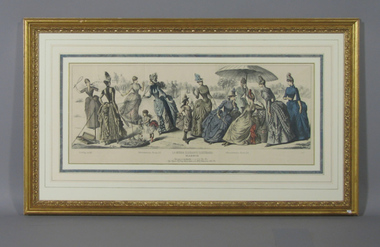 Tennis Australia
Page from Magazine, 1887
A triple foldout page from magazine 'La Moda Elegante Illustrada' issue 22 May 1887. Colour lithograph features fashions modelled by 12 female figures standing on a tennis court, some holding racquets. Materials: Ink, Cardboard, Glass, Paper, Metaltennis -
 Tennis Australia
Print, Circa 1890
Colour lithograph depicting two women in long dresses and bonnets, holding tennis racquets and standing by a high wall, and the face of a man with a lit cigarette looking over the wall from the other side. Materials: Ink, Cardboard, Cloth, Wood, Glass, Metal, Adhesive labeltennis -
 Ballan Shire Historical Society
Map - Map. Bungal, Department of Lands and Survey, Bungal, County of Grant, 09/09/1926
A map of Bungal in the 1920's showing the allotments, and the size, with the names of the residents. It shows the roads and the Western and Eastern Moorarbool River, and the Whipstick State Forest.Cream coloured map of Bungal in the County of Grant, bounded by the the East Moorarbool River on the East, and the State Forest on the South. It is marked with the scale of chains and the number L.358. Lithographed at the Department of Lands and Survey. Melbourne by W. J. Butson on 9.9.1926. It shows the land allotments with names of owners.Coloured pen marks and circled numbers on various areas. Price 2 shillings marked on bottom right hand edge.bungal, kerrit bareet, egerton, lal lal, borhoneyghurk, bungeeltap, ballark, yaloak, gorong, moorarbool west