Showing 11595 items matching " map"
-
 Federation University Historical Collection
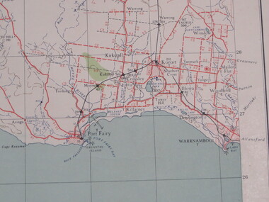
Map, Portland, 1941, 1941
Printed colour map on paperportland, port fairy, warrnambool, kirkstall, crossley, koroit, tower hill, woolsthorp -
 Federation University Historical Collection
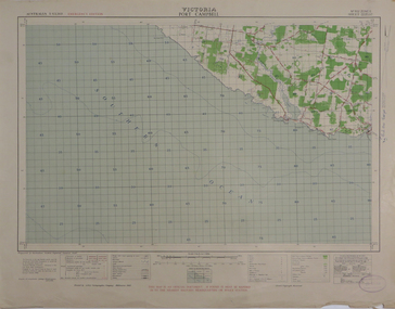
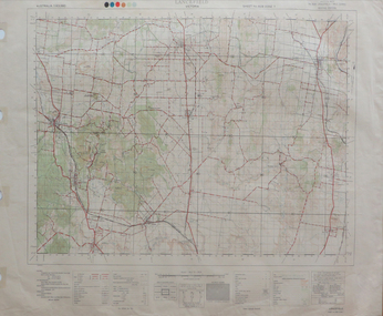
Map, Port Campbell, 1942, 1942
Printed colour map on paperport campbell -
 Federation University Historical Collection
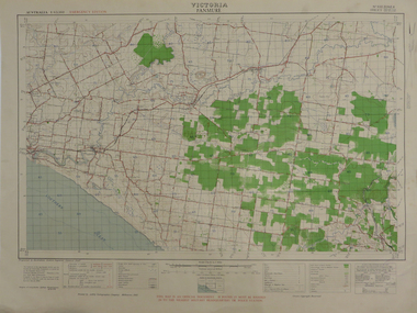
Map, Panmure, 1942, 1942
Printed colour map on paperpanmure, garvoc, curdie, allansford, bushfield, hopkins river -
 Federation University Historical Collection
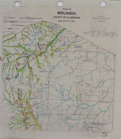
Map, Moliagul
printed map with hand colouringmoliagul, welcome stranger nugget -
 Federation University Historical Collection
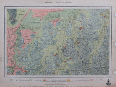
Map, Geological Survey of Victoria, 1913
Printed colour map on papervictoria, geological survey of victoria, gladstone, talbot -
 Federation University Historical Collection
Map, Lancefield, 1947
Printed coloured map on paperlancefield -
 Federation University Historical Collection
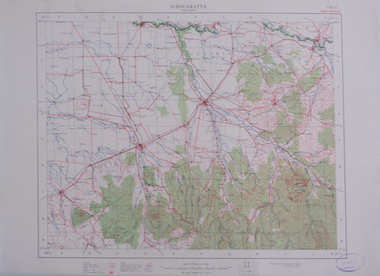
Map, Wangaratta, not dated
Printed colour map on paperwangaratta, broken river, ovens river, benalla, euroa -
 Federation University Historical Collection
Map, Yan Yean, 1935, 05/1935
Printed colour map on paperyan yean -
 Whitehorse Historical Society Inc.
Map, Proposed Mullum Mullum Park, 6/05/2008
Map produced by Parks Victoria.Map produced by Parks Victoria.Map produced by Parks Victoria.mullum mullum park, maps -
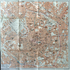 Ballarat Heritage Services
Map, Milano, 1924, 1924
Map of Milano, Italy in 1924milano, milan, italy -
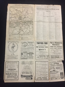 The 5th/6th Battalion Royal Victoria Regiment Historical Collection
Map, Britain and Underground Railways, July 1919
Used by Australian Soldiers whilst on leave after WW1.Reversible map made of paper. One side has a map of Britain and Ireland printed in colour, the other has a map of the London underground as well as several advertisements. there are small tears along the fold lines.wark vc club, regiment property -
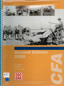 Victorian Aboriginal Corporation for Languages
Map, Country Fire Authority, Region 6 rural directory, 2000
maps, b&w photographscolac, lismore, cressy, lake corangamite, camperdown, terang, cobden, peterborough, port campbell, apollo bay, forrest, victorian regional maps, fire protection -
University of Melbourne, Burnley Campus Archives
Plan (Item) - Burnley Gardens, Map 2. Existing Conditions
Annotations in ink and pencil on 1 copy of 5 -
 Greensborough Historical Society
Map, Melbourne and Metropolitan Board of Works. Survey Division, MMBW, Yarra 2500 / 14.27. Yarrambat, Yan Yean Road, 1978_04
Melbourne and Metropolitan Board of Works. Yarra 2500 [base map] 14.26. Yarrambat, Yan Yean Road. Parishes of Morang 3183 and Greensborough 2724. Municipality of Diamond Valley 257. Prominent streets include: Yan Yean Road, North Oatlands Road and Pioneer Road. Features include Yarrambat War Memorial Reserve.MMBW Map in 1:2500 [scale] series. Cream parchment with green tape reinforcing on edges and punched holes on left edge.mmbw, melbourne and metropolitan board of works, shire of diamond valley, whttlesea, yarrambat - maps -
 Phillip Island and District Historical Society Inc.
Document, 1869 Crown Land sale and map of Phillip Island showing allotments
Anderson and McHaffie were prominent early settlers of Phillip Island. These documents were from the estate of Stan Mcfee snr. Listings of auctions at Gemmell, Tuckett & Co., Collins Street, Melbourne 12 February, 1869HistoricalCopy of map showing allotments for 1869 land sale and hand written note showing allotments, area, prices for purchases of Robert Anderson and notes on McHaffie land.robert anderson, glen isla, john mchaffie, maps, land sales -
Ringwood and District Historical Society
Envelope, Packet: War Workers (WW2) - Fall of Singapore, Burma Railway Map, Special Editions of Newspapers 1992-993
World War II - Newspapers - 50th anniversary editions; The Australian - Special edition "The Fall of Singapore", "The Day Destiny Struck", Australia at War, Map of Burma Railway -
 Whitehorse Historical Society Inc.
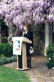
Photograph, Launch of Valley of the Arts Tourist Map, 1/10/2000 12:00:00 AM
Coloured photo of Chief Executive Officer of City of Whitehorse, Noelene Duff, speaking at the launch of the Valley of the Arts Tourist Map at Schwerkolt Cottage on 6 October 2000.city of whitehorse, duff, noelene, valley of the arts, schwerkolt cottage -
 Whitehorse Historical Society Inc.
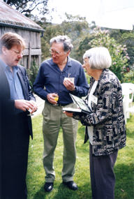
Photograph, Launch of Valley of the Arts Tourist Map, 1/10/2000 12:00:00 AM
Coloured photo of Bruce Atkinson, M.L.C., Ted and Valda Arrowsmith (President of Society) at the launch of the Valley of the Arts Tourists Map at Schwerkolt Cottage on 6 October 2000.victoria.legislative council. koonung province, atkinson, bruce, arrowsmith, ted, valda -
 Whitehorse Historical Society Inc.
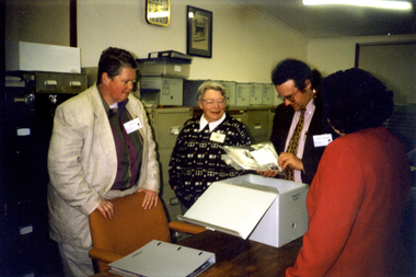
Photograph, Map Visit, 1/11/1999
Coloured photo of Map Representatives on Museum's Accreditation Inspection Visit, L-R - Jude Fraser, Barbara Gardiner (NDHS Secretary), Matthew Churchward, Elizabeth Triarico.schwerkolt cottage and museum complex, museums australia (vic). museum accreditation program, fraser, jude, gardiner, barbara, churchward, matthew, triarico, elizabeth -
 Greensborough Historical Society
Map, Melbourne and Metropolitan Board of Works. Survey Division, MMBW, Yarra 2500 / 11.22. Bundoora, 1979_01
Melbourne and Metropolitan Board of Works. Yarra 2500 [base map] 11-22. Bundoora. Parish of Keelbundoora 2856, Municipalities of Diamond Valley 257 and Whittlesea 239. Prominent streets include: Greenhills Road, Cabernet Crescent and Plenty Road. Includes Parade College (Christian Brothers) and "proposed future freeway" (now Metropolitan Ring Road)MMBW Map in 1:2500 [scale] series. Cream parchment with green tape reinforcing on edges and punched holes on left edge.mmbw, melbourne and metropolitan board of works, shire of diamond valley, bundoora - maps -
 Greensborough Historical Society
Map, Melbourne and Metropolitan Board of Works. Survey Division, MMBW, Yarra 2500 / 15.21. Eltham North, 1979_08
Melbourne and Metropolitan Board of Works. Yarra 2500 [base map] 15.21. Eltham North. Parish of Nillumbik 3310. Municipalities of Diamond Valley 257 and Eltham 238. Prominent streets include: Progress Road, Glen Park Road and Zig Zag Road. Features include the Diamond Creek, Eltham Council Pound and Eltham North Reserve.MMBW Map in 1:2500 [scale] series. Cream parchment with green tape reinforcing on edges and punched holes on left edge.mmbw, melbourne and metropolitan board of works, shire of diamond valley, nillumbik, eltham - maps -
 Greensborough Historical Society
Map, Melbourne and Metropolitan Board of Works. Survey Division, MMBW, Yarra 2500 / 14.23. Diamond Creek, Sutherland Homes, 1979_05
Melbourne and Metropolitan Board of Works. Yarra 2500 [base map] 14.23. Diamond Creek, Sutherland Homes. Parish of Morang 3183 and Nillumbik 3310. Municipality of Diamond Valley 257. Prominent streets Aqueduct Road, Diamond Creek Road, Yan Yean Road and McLaughlans Lane. Features include the abandoned Maroondah aqueduct and Sutherland Cottages.MMBW Map in 1:2500 [scale] series. Cream parchment with green tape reinforcing on edges and punched holes on left edge.mmbw, melbourne and metropolitan board of works, shire of diamond valley, plenty - maps, sutherland homes, maroondah aqueduct -
 Greensborough Historical Society
Map, Melbourne and Metropolitan Board of Works. Survey Division, MMBW, Yarra 2500 / 13.28. Mernda, Wilton Vale, 1977_08
Melbourne and Metropolitan Board of Works. Yarra 2500 [base map] 13.28. Mernda, Wilton Vale. Municipality of Diamond Valley 257 and Whittlesea 239. Prominent streets: Wilton Vale Road. Features include Yan Yean Pipe Track and SEC Transmission Lines. The abandoned rail line (old Whittlesea line) is in the top left corner.MMBW Map in 1:2500 [scale] series. Cream parchment with green tape reinforcing on edges and punched holes on left edge.mmbw, melbourne and metropolitan board of works, shire of diamond valley, mernda - maps -
 Melbourne Tram Museum
Map - CD - Sands McDougal Map Melbourne c1906, Sands McDougall
Detailed scan of the Sands McDougal Map in colour showing Melbourne's cable trams, railways, Essendon Tramways, NMETL and the Victorian Railways line to Brighton from St Kilda. Includes the MTOCo horse tram lines and the Caulfield horse tram lines. See Reg item 6572 for the actual map. Yields information about Melbourne and its tramways in 1906CD in a plastic case - black with clear cover.CD marked "Sands & McDougal Map c1906"cable trams, tramways, map, sands mcdougal, nmetl, vr trams, horse trams -
Whitehorse Historical Society Inc.
Map, City of Nunawading, c1975
Map of City of Nunawading, showing location of 186 parks and reserves.Map of City of Nunawading, showing location of 186 parks and reserves. Scale 1:10,000 with list of streets and their map coordinates.Map of City of Nunawading, showing location of 186 parks and reserves. city of nunawading, parks and reserves -
 Greensborough Historical Society
Map, Melbourne and Metropolitan Board of Works. Survey Division, MMBW, Yarra 2500 / 13.19. Lower Plenty, Montmorency, Yallambie, 1979_02
Melbourne and Metropolitan Board of Works. Yarra 2500 [base map] 13-19. Lower Plenty, Montmorency, Yallambie. Parishes of Keelbundora 2856 and Nillumbik 3310. Municipalities of Heidelberg 228, Diamond Valley 257 and Eltham 238. Prominent streets include: Elder Street, Para Road, and Main Road Lower Plenty. Includes Watsonia Army Barracks.MMBW Map in 1:2500 [scale] series. Cream parchment with green tape reinforcing on edges and punched holes on left edge.mmbw, melbourne and metropolitan board of works, shire of diamond valley, montmorency - maps, yallambie - maps, lower plenty - maps -
Glenelg Shire Council Cultural Collection
Print - Print, reproduction, F. W. Birmingham, Map of the town of Portland in the colony of Victoria, 1853
Town of PortlandFramed illustration of a map of the Town of Portland from a stone etching published by F.W. Birmingham, Dec.1853. Mounted and framed in stained black timber frame under glass.Front: (no inscriptions) Back: (no inscriptions) -
 Bendigo Military Museum
Photograph - Co-ordinatorgraph Map Grid Production, Army Survey Regiment, Fortuna Bendigo, c1960s to 1970s
This is a set of seven photographs of map grid production using co-ordinatorgraphs at the Army Survey Regiment, Fortuna Bendigo. c1960s to 1970s. The Aristo Co-ordinatorgraph introduced in 1962 was a large heavy steel framed light table with a scribing head that moved in a XY direction using a vernier calibrated measuring scale to 0.001 of an inch. Whilst hand operated it was much quicker and accurate than manual grid and graticule calculation, plotting and scribing. Mapping PNG presented the Regiment with many challenges. WO1 Farrington and CPL John Dean developed computer software for the digitally controlled co-ordinatorgraph, the Calcomp 718 Flatbed Plotter. Much time was saved by automatically plotted cartographic grids and graticules, and automatically draw base compilation sheets complete with aerial triangulated stereo model control. This could be used for a number of maps and was the first step towards map automation. The history of co-ordinatorgraphs is covered in more detail with additional historic photographs, in pages 50 to 51 and page 88 of Valerie Lovejoy’s book 'Mapmakers of Fortuna – A history of the Army Survey Regiment’ ISBN: 0-646-42120-4. SGT Bill Boyd appearing in photo .1P reach the rank of WO1 and for 11 years was the technical warrant officer at the Detachment Army Survey Regiment located at Bonegilla, Victoria. He was awarded the OAM, the Order of Australia Medal for the development of the Flexiflow quality control system. This system comprised a series of job plans and charts linked to a task allocation to resource magnetic planning board. Using critical path analysis and task prioritisation, complex job planning was efficiently scheduled, and re-prioritisations readily made. Reproduction requirements were effectively coordinated by way of weekly courier to the Army Survey Regiment. Supervisors and technicians fully embraced the system as they could understand their role, others around them and the positive production achievements. Bendigo. See page 178 of Valerie Lovejoy’s book for more information on WO1 Boyd’s contribution to RA Svy.This is a set of seven photographs of map grid production using co-ordinatorgraphs at the Army Survey Regiment, Fortuna Bendigo. c1960s to 1970s. The photographs were printed on photographic paper and are part of the Army Survey Regiment’s Collection. The photographs were scanned at 300 dpi. .1) - Photo, black & white, c1960s, L to R: SGT Bill Boyd demonstrating Aristo Co-ordinatorgraph equipment to unidentified technicians (x3) .2) - Photo, black & white, c1960s, Aristo Co-ordinatorgraph equipment. .3) - Photo, black & white, c1960s, unidentified technician operating Aristo Co-ordinatorgraph equipment. .4) - Photo, black & white, c1960s, L to R: PTE Desi Asaris and CPL Kalen Sargent operating Aristo Co-ordinatorgraph equipment. .5) - Photo, black & white, Photo, black & white, c1970s, John Bloor operating Calcomp co-ordinatorgraph equipment. .6) - Photo, black & white, Photo, black & white, c1970s, unidentified technician operating Calcomp co-ordinatorgraph equipment. .7) - Photo, black & white, Photo, black & white, c1970s, L to R: SGT Andy Covington and SGT John Waight operating Calcomp co-ordinatorgraph equipment..7P annotated on back ‘Covington & Waight’.royal australian survey corps, rasvy, army survey regiment, army svy regt, fortuna, asr, carto, air survey -
 Ballarat Tramway Museum
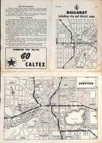
Map, RACV - Royal Automobile Club of Victoria, "Ballarat including city and district maps", 10/1961
Shows the central part of Ballarat, Ballarat Outlets, streets, principal attractions, Ballarat and district maps and information. Has the tram lines shown dotted, does not run out to Sebastopol or the Lydiard St North terminus. Each map in the bottom left-hand corner has the number "1061", possibly indicating the date. Has notes on the City, points of interest, and an advertisement for Caltex. See item 4929 for a larger version dated 1966. Yields information about the extent of Ballarat in the early 1960's shows the tram lines and other rail lines in the district. Four fold map printed on white paper, titled "Ballarat including city and district maps" - Map No. MAP 15.314 and dated 10-61. Produced by the RACVmap, tranways, ballarat, racv, railways -
 Greensborough Historical Society
Map, Melbourne and Metropolitan Board of Works. Survey Division, MMBW, Yarra 2500 / 14.22. St Helena, St Katherine's Church, 1979_08
Melbourne and Metropolitan Board of Works. Yarra 2500 [base map] 14.22. St Helena, St Katherine's Church. Parish of Nillumbik 3310. Municipality of Diamond Valley 257. Prominent streets St Helena Road, Weidlich Road, Yan Yean Road and Allumba Drive. Features include St Katherine's Church of England and the St Helena Secondary College site.MMBW Map in 1:2500 [scale] series. Cream parchment with green tape reinforcing on edges and punched holes on left edge.mmbw, melbourne and metropolitan board of works, shire of diamond valley, st helena - maps, st katherines church st helena