Showing 2472 items matching " township"
-
 Bendigo Historical Society Inc.
Map - LOCAL AREA PLANS, See above
Map: Compilation of maps: Village of Redcastle dated april 14 1861, Township of Yarraberb dated 14 July 1874, Hamlet of White Hills dated December 27 1872, Road survey of Toolleenmap, parish plan, redcastle, yarraberb, white hills, toolleen -
 Clunes Museum
Document - PLAN, CONSERVATION MANAGEMENT PLAN, UNKNOWN
FINAL DRAFT OF CONSERVATION MANAGEMENT PLAN NOVEMBER 2018 FOR CLUNES FREE LIBRARY TEMPLETON STREET. FOLDER INCLUDES HISTORY OF CLUNES TOWNSHIP. THE BURRA CHARTER, HISTORY OF MECANICS INSTITUTE (FREE LENDING LIBRARY)conservation managment plan, free library -
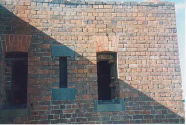 Clunes Museum
Photograph, KODAK, 1999
VIEW OF POWDER MAGAZINE USED IN MINING DAYS TO STORE EXPLOSIVES. BUILDING MATERIALS SOLID BRICKCOLOURED REPRINT PHOTOGRAPH OF POWDER MAGAZINE EXTERIOR. SITUATED IN A PADDOCK ON SMEATON ROAD APPROX. 2 KM. FROM TOWNSHIP ON LEFT HAND SIDE. A SOLID BUILDING WITH TWO OPENINGS AND ONE SMALL WINDOWlocal history, photography, photographs, mining -
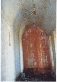 Clunes Museum
Photograph, KODAK, 1999
VIEW OF POWDER MAGAZINE USED IN MINING DAYS TO STORE EXPLOSIVES. BUILDING MATERIALS SOLID BRICKCOLOURED PRINT PHOTOGRAPH OF POWDER MAGAZINE INTERIOR. SITUATED IN A PADDOCK ON SMEATON ROAD APPROX. 2 KM. FROM TOWNSHIP ON LEFT HAND SIDE. SHOWING ARCHED ROOF SMALL WINDOW IN LEFT WALL.local history, photography, photographs, mining -
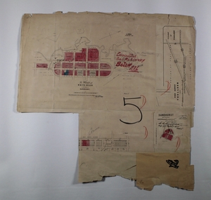
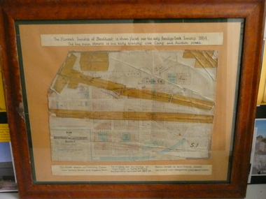 Bendigo Historical Society Inc.
Document - PLAN OF TOWNSHIP OF SANDHURST 1854, July 25. 1854
Coloured- The planned township of Sandhurst is placed over the early Bendigo creek township of 1854. The two main streets of the early township were Camp and Auction streets. The street shown as Dowling street later became Queen & Hopetoun streets. The building near the bridge at View Point is Pykes Building. The Post Office was located here in 1854 - 58. Bernal street is now Chapel street. The creeks were straightened to their present courses. Streets on map are. Pall Mall - Bridge - McCrae - Hargraves - Lyttleton - Myers - Mollison - McLaren - Mitchell - Williamson - Mundy - Bernal - Baxter - Larritt - Bramble - McIvor - Bull. Also shown on map: Bendigo Creek - Government Reserve - Present Cemetery - Proposed diversion of creek. FH 562 Deframed 2022Lithographed at Surveyor Generals Office. Melbourne. July 25. 1854. By R. Meikle.place, bendigo, original 1854 bendigo map -
 Marysville & District Historical Society
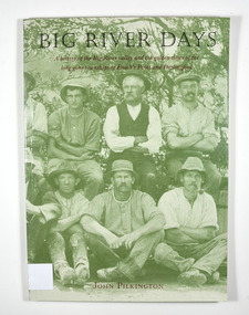
Book, Big River Days-A history of the Big River valley and the golden times of the long gone townships of Enoch's Point and Darlingford, 1996
A history of the Big River valley and the townships of Enoch's Point and Darlingford, VictoriaPaperback. Cover has a photograph of a group of men sitting and crouching for a group photograph. There are trees in the background.for Doug - / With best wishes,/ John Pilkington / January 2000 To the memory of my parents,/ Ralph and Florence Pilkington Stamp of the Marysville & District Historical Society Inc / P.O. Box 22 / Marysville 3779enoch point, darlingford, big river, victoria, australia, history, john keith pilkington -
 Halls Gap & Grampians Historical Society
Document - Photocopy of article (magazine/newspaper)
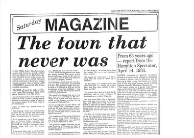
Article about the proposed Henham township site and its subsequent failure.Copy of a newspaper article from the Hamilton Spectator, Saturday Magazine, Saturday June 1, 1996.townships, henham, media, newspaper articles -
Tatura Irrigation & Wartime Camps Museum
Folder, Waranga Basin Environs, 1999
Township created by Waranga construction. Photographic description of pre/post construction.Black folder, met ring binders, white label. Contains photographic record of environswaranga basin environs, weppner j, price t, irrigation, waranga basin construction -
 Lakes Entrance Historical Society
Photograph - Footbridge, 1999c
This photo taken from township side (northern side looking southward)Color photograph of the footbridge across Cunninghame Arm. It shows the shortened footbridge with the path and recently established lawn and trees. Surf lifesaving club on sand dunes in background. Lakes Entrance Victoria waterfront, bridges -
 Lakes Entrance Historical Society
Postcard
Black and white postcard showing Esplanade, cenotaph Lakes Entrance VictoriaView from lookout tower Lakes Entranceroads and streets, township -
 Lakes Entrance Historical Society
Postcard
Black and white postcard showing Post Office jetty and shoreline with buildings in the background Lakes Entrance Victoriatownship, jetties -
 Lakes Entrance Historical Society
Photograph - Stewart's Butcher Shop, Davies, Judy, 2005
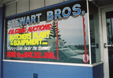
Auction of plant and equipment in January 2005. Business started 1935c by Could Stewart. Last owner was Ian McNamara.Colour photograph of Stewarts Butcher Shop Esplanade, taken prior to the business closing down. Lakes Entrance Victoriatownship, retail trade -
Lakes Entrance Historical Society
Book, Blake L J, Place Names of Victoria, 1977
An alphabetical list of some of the place names of Victoria with approximate location, and explanation of the name and date of naming. List of references.township, topography -
Lakes Entrance Historical Society
Book, Gippsland Heritage Journal, 1993
No 15 of a series of Journals showcasing areas of Gippsland Victoria history includes items on Cassilis, Maffra, Yallourn, Omeo and Tarra Valley.periodicals, township -
Lakes Entrance Historical Society
Book, McLaren Pauline Parrington Geoff Sarins Lorrri, Reflecting Gippsland
The story of the public art in the mall of the city of Sale Victoriaarts, township -
Lakes Entrance Historical Society
Book, Church of England in the Diocese of Gippsland, The Gippsland Anglican December 1975, 1975
Issue of Gippsland Anglican Church News containing brief account of Reverend Francis Hales, pioneers Minister of the Church of England in Gippsland. Also mentions Reverend E G Pryce and other pioneer Church of England clergy in what is now the state of Vireligion, township -
Lakes Entrance Historical Society
Book, Goff John, Hunt Cecil, The Story of Two Mustard Seeds, 1986
Discribes the church and the area it stands in Lakes Entrance VictoriaPresented to the Tambo shire Historical society with the compliments of the Lakes Entrance Uniting Church April 1986religion, township -
Lakes Entrance Historical Society
Book, History of the Nicholson Union Church 1890-1990, 1991
A short history of the Union Church at Nicholson Victoria. Names of the ministers-congregational, Methodist and Church of England, who led worship are listed, stories of the area and community are includedreligion, township -
Lakes Entrance Historical Society
Book, Campbell Kenneth W, 100 Years of Saints and Sinners The Centenary History of the Anglican Parish of Bruthen in East Gippsland, 1992
A centenary history of St Matthews Anglican Parish of Bruthen,Victoria which includes history and development of the region, establishment of the Church, priests and lay readers, and the other communities served, ie Sarsfield, Wiseleigh, Mossiface, Tamboreligion, township -
Lakes Entrance Historical Society
Book, Bairnsdale Shire Council Centenary 1868, 1968
A short history of the Shire of Bairnsdale Victoria from beginnings as a road district to the separation of the commercial centre as the Towns of Bairnsdale illustrated with photographs. A list of Shire Presidents and officers is included.township, photography -
 Lakes Entrance Historical Society
Photograph, 1995
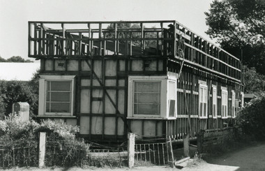
Date made December 1995Black and white photograph of a house in process of demolition situated on Esplanade, Lakes Entrance, Victoria.township, houses -
 Lakes Entrance Historical Society
Photograph - Butcher's Paddock, 1935c
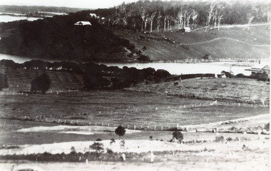
Copied from postcard in possession of Mrs Vera BennettBlack and white photograph of cleared land on each side of the North Arm, showing white ring barked trees in front of dense bush on western side, cleared and fenced paddocks on eastern side. Lakes Entrance VictoriaPanorama scene at Seaview Tearooms - Lakes Entrancetownship, waterways -
Lakes Entrance Historical Society
Book, Eagle, Chester, Hail and Farewell, 1971
A critical view of Gippsland and its inhabitants formed by the author during a teaching appointment at Bairnsdale Technical School from 1956 to 1968schools, township -
 Lakes Entrance Historical Society
Photograph - Port Albert Hotel, 1985 c
Colour photo of the hotel at Port Albert, showing a neat weatherboard building with verandah and balcony on upper storey, close to water edge. Port Albert Victoriahotels, township -
 Lakes Entrance Historical Society
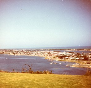
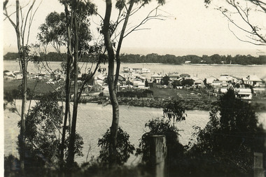
Photograph - Lakes Entrance, Fraser, Nancy, 1985c
Colour photograph of a bend in the North Arm. It shows the sports ground, eastern end of town. Jetties and hire boats at edge of lake. Photo taken from cleared hill, Kalimna, in foreground. Bass Strait in distance. Lakes Entrance Victoriawaterways, township -
 Lakes Entrance Historical Society
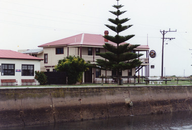
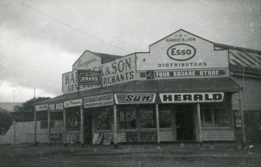
Photograph - Harbeck's Store, 1964c
Store was opened 1890c by Peter Harbeck, ancestor of the people standing at the front of the store. Photo taken after sale of the store in 1960's. In the photo are Mrs Northrope (Cross), Charlie Hancock, Tommy Harbeck, Eva Harbeck. Black and white photograph of Harbecks Store, Esplanade, showing old style general store. Built of weatherboard, with iron roof. Situated on the corner of Carpenter Street, a veranda with wooden floor shelters front and side of store. Lakes Entrance Victoriatownship, retail trade -
 Lakes Entrance Historical Society
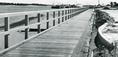
Photograph - Thunderbird, Lakes Post Newspaper, 1991
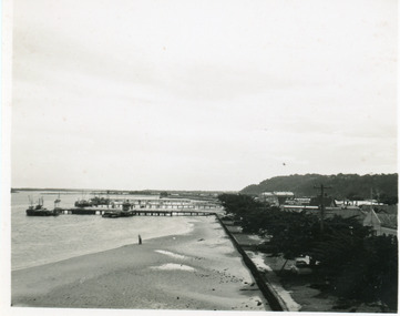
Date made November 1991Black and white photograph of the waterfront walkway, showing a timber footpath and guard railings concrete edgings being constructed beside car park. Sandy beach and seaweed at edge of lake, fishing boats and tourist boat Thunder Bird moored at wharf in background. Lakes Entrance Victoria township, waterfront -
 Lakes Entrance Historical Society
Postcard - North Arm, 1930 c
Second copy has inscription Glimpse of Lakes Entrance ( on back)Black and white small format postcard, taken from a tea room known as Cream Cottage on the Kalimna Heights escarpment. It shows posts & trees in foreground, waters of North Arm, cottage facing North Arm, rear view of dwellings facing Cunninghame Arm, Broomes Federal Baang Yarnda houseboat, sand hummocks on southern shore. Lakes Entrance Victoria'View from Cream Cottage' (on back)township, waterways -
Merbein District Historical Society
Administrative Record, Ledger, Irrigation Rate Book - Merbein (Parish), 1921-1929
township, state rivers and water supply commission -
Merbein District Historical Society
Administrative Record, Ledger, Irrigation Rate Book - Merbein (Urban), 1927-1930
township, state rivers and water supply commission