Showing 764 items matching " view point"
-
 Phillip Island Conservation Society Inc.
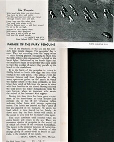
Work on paper - Photocopy of newsletter article, Gould League of Bird Lovers, "Parade of the Fairy Penguins", 1966
By 1966 when this poem and article were written by these state school students, the Phillip Island Penguin Parade had become famous and was a regular excursion destination for groups. The poem in rhyming couplets of 4 lines per stanza is typical of its time with human-centric description of the penguins in 'coat and tails', but both the poem and essay also indicate a growing interest in the evolution and behaviour at sea and on land of the Little Penguins. The Gould League of Bird Lovers, Victoria branch, which published these pieces in their 1966 edition of the Bird Lover magazine, was established for both children's 'nature studies' within school curricula, and for adults. The League published many booklets, posters and newsletters for schools and naturalists. The article demonstrates a growing interest in state schools in teaching students about Australian wildlife at the time. Little Penguins are very appealing to humans and given the accessiblity for viewing them at the Phillip Island Penguin Parade, provided teachers and students an ideal springboard for learning. Encouraging both poetry and essay form also indicated a broad approach to allowing students to express their knowledge and attitudes in various ways within the school setting.Also demonstrates the influence of the Gould League of Bird Lovers within the Victorian Education system.Photocopy of article. Black print on white paper with single greyscale image. Three-stanza poem "The Penguin" by Janice Ah Kee, followed by 4-paragraph description of life in the rookery by Diana Joseph. Both from Victorian state schools.litte penguin, fairy penguin, , bird lover, state school 3125 eagle point, state school 4655 morwell, janice ah kee, diana joseph, christine ryan photo, phillip island penguin parade, gould league of bird lovers, gould league of victoria, phillip island nature parks -
 Phillip Island Conservation Society Inc.
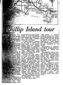
Work on paper - Photocopy of newspaper cutting, "Phillip Island tour", circa 1950s?
... (Point Grant), with views of the Seal Rocks offshore through... there, and the Nobbies (Point Grant), with views of the Seal Rocks offshore ...The article relates the journalist's visit to Phillip Island, starting from Melbourne and describing features along the way, then at San Remo on mainland side of Phillip Island bridge, then Newhaven on the other. Other places visited include the main town of Cowes, the jetty and beach there, and the Nobbies (Point Grant), with views of the Seal Rocks offshore through telescope at the Nobbies. The writer also visited Summerland beach, described as a surf beach, with penguin and mutton bird rookeries. While not specifically referring to the Penguin Parade, the writer says the spectacle of seeing the penguins coming ashore is not to be missed. The brief military colony at Rhyll and the first Victorian 'garden' planted at Churchill Island in 1801 are also mentionedArticle is significant because it is an early (1950s?) tourist guide to Phillip Island's most popular tourist destinations. 3 column text under map of Phillip Island. Black print on white paper. phillip island, newhaven, , westernport, surf beaches phillip island, summerland beach, penguins, mutton birds, the nobbies, point grant, seal rocks, cowes, nobbies blowhole, rhyll, churchill island, nobbies telescope -
 Phillip Island Conservation Society Inc.
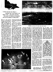
Work on paper - Photocopy of newspaper cutting, "PHILLIP ISLAND/A place to fall in love"
This article was written by an English visitor named Elsa Christian who was touring Australia and New Zealand with her husband Frank in their own small van. The article was published in the Australian Women’s Weekly, magazine, March 1966. Elsa writes she wanted to visit four Australian locations before she died: Ayers Rock (actually Uluru), the Snowy River project, dolphins at Coolangatta and the Penguin Parade at Phillip Island. These destinations were all very popular in the 1960s for both Australian residents and overseas visitors. Because the roads were becoming better too many locations, self guided tours in small vans for cars towing bond would caravans were becoming more popular means of seeing AustraliaThe article is significant in many ways. 1. Indicates the places English visitors commonly wish to see in Australia. 2. Describes the growing trend to self- drive van/camping holidays. 3. Gives the route taken from Melbourne to Phillip Island during the 1960s. 4. Describes the appearance of the roadsides and locations visited. 5. It is written in a descriptive and lyrical style designed to appeal to Women’s Weekly magazine readers, who were probably wondering how they could visit Phillip Island with their husbands or families themselves, and what there was to see there. 6. Gives the visitors’ view of how the Penguin Parade operated at the time. 7. Includes a description of potter and artist Eric Juckert’s renowned garden at Grossard Point, Ventnor. 8. Indicates how introduced plants such as Hawthorn pushes and Kate weed were common in the area. 9. Describes Phillip Island as “a place to fall in love” because of its natural beauty, fauna and coastal seascapes. 10. As a visitor Elsa describes the housing estates as a blot on the landscape, but also sees the value as a way of their owners escaping from the hustle and bustle of Melbourne. 11. Gives the visitors’ interpretation of the behaviour of wildlife the RC in the wild, as well as Elsa’s knowledge about some of the species she encounters.Photocopy of full page article with 5 columns of text, a map and 2 photographs. Black ink on white paper. Photographs blackened in photocopying processphillip island, cape woolamai, penguin parade, seal rocks, nobbies, township of rhyll phillip island, princes highway, dandenong, pakenham, kooweerup, carinya creek, officer, san remo, gippsland highway, holiday homes, fort dumaresq, kitty miller's beach, wreck of the speke, hereford cattle, fleetwood manor, koalas, ventnor, eric juckert, little penguin behaviour -
 Wodonga & District Historical Society Inc
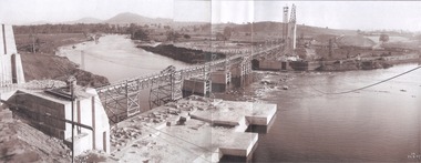
Album - Hume Reservoir Australia Album - General View of Works from New South Wales end, Looking Upstream, August 1927
This set of photos is from a leather bound album bearing the inscription "HUME RESERVOIR AUSTRALIA" plus 'The Rt. Hon. L. C. M. S. Amery, P. C., M .P.' all inscribed in gold. It was presented to The Rt. Hon. L. C. M. S. Amery, P. C., M. P, Secretary of State for Dominion Affairs on the occasion of his visit to the Hume Reservoir on 2nd November 1927. This album is of local and national significance as it documents the planning and development of the Hume Reservoir up to 1927. It was the largest water reservoir in the British Empire. The album records the pioneering engineering work that went into its construction.DEPARTMENT OF PUBLIC WORKS, N.S.W. RIVER MURRAY WATERS SCHEME. HUME RESERVOIR. 22. General View of Works from New South Wales end, Looking Upstream. Features: At the left, part of the North Wing Wall, the highest part of which is 26 feet below its ultimate height. Below in the foreground is the portion of the dam where provision is to be made for hydro-electric generation. The tubes, three in number, 13 feet in diameter, will be laid on the level shown and an early start will be made in laying them. The level for the other four regulating outlets, 9 feet in diameter, together with a part of the spillway section of the dam, is underwater at this stage and it may be remarked that at one point, about half way across the channel where the water is now flowing, the concrete foundations are about 80 feet below the level of the water. The broken surface of the water is due to the large “plums” in the concrete. The still water in the right foreground is the stilling pool over the concrete floor of which there is now more than 20 feet of water and by means of which the discharge from the outlet pipes will be quelled. The trestlework on the upstream side of the dam carries the concrete belt conveyor. It extends from the concrete mixer house, which is out of the picture, behind the wing wall, along almost the entire length of the concrete portion of the dam. The concrete is discharged from the belt at any desired point by means of trippers, one of which may be seen over the second trestle. On the other side of the flowing water is the coffer dam. A channel 300 feet wide involving about 140,000 cubic yards of excavation and dug for the temporary diversion of the river as it is flowing now. To the right top of the view beyond the Coffer Dam is the earth embankment being thrown across the major part of the valley by the Victorian Constructing Authority. The Mitta Mitta River flows into the Murray at the far end of the reach of water on the left. August 1927.hume reservoir australia, river murray waters scheme, hume reservoir construction -
 Wodonga & District Historical Society Inc
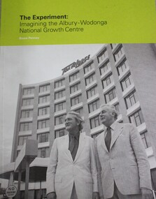
Booklet - THE EXPERIMENT : Imagining the Albury - Wodonga National Growth Centre, Bruce J Pennay, 2013
... of the story with emphasis on a local point of view. " Bruce Pennay ...Introductory Abstract - "On its instigation in 1973, the Albury-Wodonga Growth Centre experiment was hailed as a novel and imaginative project. It was a "pilot scheme" that was expected to influence the urban settlement pattern in Australia. It was a "bold venture", a "brave attempt" to solve a longstanding problem. It involved three governments embarking on an "exciting adventure". This short book length catalogue essay (51 pages) provides an illustrated guide to the social history and visual arts exhibitions mounted for the 40th anniversary in 2013 of the inauguration of the Albury-Wodonga National Growth Centre experiment. The essay served as rationale and support for two council exhibitions at the Albury Library Museum and the Arts Space Wodonga in October and November 2013. The background story and the exhibitions are about place-making. They ask about the kind of place that has been made at Albury-Wodonga. How was it imagined, promoted, grown? They examine the experiment of developing Albury and Wodonga jointly and rapidly, and ask how that experiment relates to the place now and in the future. It assesses and gives a broad contextual account of the National Growth Centre experiment at Albury-Wodonga and traces important aspects of the story with emphasis on a local point of view. " Bruce Pennaynon-fictionIntroductory Abstract - "On its instigation in 1973, the Albury-Wodonga Growth Centre experiment was hailed as a novel and imaginative project. It was a "pilot scheme" that was expected to influence the urban settlement pattern in Australia. It was a "bold venture", a "brave attempt" to solve a longstanding problem. It involved three governments embarking on an "exciting adventure". This short book length catalogue essay (51 pages) provides an illustrated guide to the social history and visual arts exhibitions mounted for the 40th anniversary in 2013 of the inauguration of the Albury-Wodonga National Growth Centre experiment. The essay served as rationale and support for two council exhibitions at the Albury Library Museum and the Arts Space Wodonga in October and November 2013. The background story and the exhibitions are about place-making. They ask about the kind of place that has been made at Albury-Wodonga. How was it imagined, promoted, grown? They examine the experiment of developing Albury and Wodonga jointly and rapidly, and ask how that experiment relates to the place now and in the future. It assesses and gives a broad contextual account of the National Growth Centre experiment at Albury-Wodonga and traces important aspects of the story with emphasis on a local point of view. " Bruce Pennayalbury-wodonga, decentralisation, urban settlement australoa -
 Wodonga & District Historical Society Inc
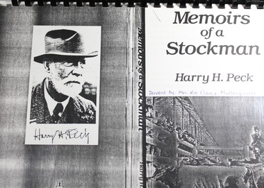
Booklet - Memoirs of A Stockman - Harry H. Peck, Harry H. Peck, 1942
... , especially of Newmarket from the point of view of Harry Peck ...This book is a compilation of the memoirs of Harry H. Peck, a stockman who was associated with Newmarket in Victoria for almost 70 years. It is written as a history of stock marketing, especially of Newmarket from the point of view of Harry Peck, and is compiled from his own memories and experiences along with the help of others who had records of the early days of Newmarket. The book covers stock market history from the 1840s to the 1940s, and includes chapters on the history of Newmarket, famous cattlemen, Gippsland pioneers, Westernport, the Great Kyogle land deal, Goulburn, Albury, Murray, Kiewa and Mitta Runs, Holbrook and many others.non-fictionThis book is a compilation of the memoirs of Harry H. Peck, a stockman who was associated with Newmarket in Victoria for almost 70 years. It is written as a history of stock marketing, especially of Newmarket from the point of view of Harry Peck, and is compiled from his own memories and experiences along with the help of others who had records of the early days of Newmarket. The book covers stock market history from the 1840s to the 1940s, and includes chapters on the history of Newmarket, famous cattlemen, Gippsland pioneers, Westernport, the Great Kyogle land deal, Goulburn, Albury, Murray, Kiewa and Mitta Runs, Holbrook and many others.english -
 City of Kingston
Photograph - Colour, 6 March 1993
Edithvale is a suburb in the City of Kingston. It is located between Aspendale and Chelsea on the Port Phillip Bay and built within remnant areas of the Carrum Carrum swamp. The foreshore precinct comprises a wide sandy beach, with low sand dunes and numerous historic boat sheds. The suburb consists of older style dwellings and former holiday houses, combined with mid-century housing and newer homes. The large blocks are increasingly subdivided and the existing dwellings demolished to accommodate units and townhouses, thus changing the landscape of the area and reducing the tree canopy.The beachside suburb of Edithvale was previously part of the extensive Carrum Carrum Swamp. The area was once a source of fish and eels for the Mayone-Bulluk clan of the Bunurong people. Over time the area was drained and predominantly devoted to dairy farming and holiday houses. The farms were gradually sold and subdivided with a large number of homes built after World War II and in the 1960s. Edithvale is mainly residential with a shopping strip along Nepean Highway but little significant industry was ever established in the area apart from a plaster works and confectionary factory, both now closed.Laminated aerial colour photograph of Edithvale as viewed from Alexandra Avenue in the north to Ella Grove Chelsea/Edithvale in the south. regents Park Aspendale can be seen in the top left. The area is built-up with residential housing and facilities including Edithvale Primary School, numerous churches and the Edithvale Railway station. Large sections depict the remnant Carrum Carrum swamp. Edithvale Common and the former "Duck Inn" (Melbourne Water/Friends of Edithvale Seaford Wetlands) can be seen. Edithvale Recreational reserve, the valodrome and Edithvale Public Golf Course are prominent. The image shows vacant land in the area now known as Aspendale Gardens and the newer residential section of Chelsea Heights is not developed. A bike path has been established to cover the secondary drain. The Golf Links Court residential development located off Hughes Avenue is a large vacant block.Black type on white adhesive label: 6-3-93 Black type on white adhesive label: 25/9211, 6/3/93, 11.20 am Black type on white adhesive label: 9211 Yellow circular adhesive sticker Black pencil: 9211 6-3-93 arrow pointing Nedthvale, carrum carrum swamp, aspendale, chelsea -
 Melbourne Legacy
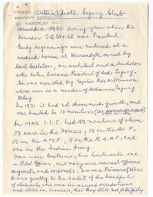
Document, Intermediate Legacy Club ILC18
... committee. A record of the activities of the ILC from the point ...A set of notes compiled by L/ Frank Doolan about the Intermediate Legacy Club (ILC). He spoke at the 1974 reunion and perhaps these notes formed part of his speech. Background: The ILC was formed in 1929. The idea of the club sprang from those boys who had outgrown the Junior Legacy Club. In the early days it fielded a lacrosse team and it was this that mainly held the members together. Enthusiasm wained after a few years as it lacked a solid objective. The answer came from one of its members and in 1938 they founded the Don Esses Club. This was a club for the children of incapacitated ex-servicemen which met every Thursday night at 7.30 run by the ILC members. The name came from the signallers' code Disabled Servicemen's Sons. During the second world war 80% of the members of the ILC enlisted in the services. Leaving only 8 members that could not join due to ill health or reserved occupations. They continued the Don Esses and whatever aid they could to Legacy. ILC members had always helped Legacy where possible including being camp leaders or camp staff, with the annual demonstrations, and coffee stalls at the ANZAC dawn service. Post second world war some ILC members were nominated into Legacy, others drifted away in civil occupations. It was found difficult to recruit new blood into the ILC and eventually membership waned when the boys from the Don Esses clubs found other youth activities to join. The ILC ceased to meet regularly in the mid fifties. However a strong comradeship still existed between members and they would meet in one anothers homes. Members were always ready to help the senior Legacy Club in any way in their power and still helped at Christmas parties and summer camps. ILC was a service rendering organisation and was self governing. Non-sectarian and non-political, the members were ex-junior legatees over 18 years of age. After serving in World War 2 members were eligible to become members of Legacy. Was in a folder of material collated about the ILC by an early archive committee. A record of the activities of the ILC from the point of view of L/ Frank Doolan who was on the archive committee in the 1970s and started collecting historical information.White note paper of various sizes handwritten by L/ Frank Doolan about the ILC.Handwritten in red pen ILC18 which was part of an early archive project numbering system. Stamped with 'Frank J Doolan' and his address in grey ink.ilc, junior legatee -
 Melbourne Legacy
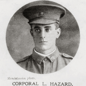
Document - Memoir, Diary 1915 Corporal Leonard Gordon Hazard
... the war from the point of view of a corporal. memoir gallipoli ...A transcription of the 1915 diary of Corporal Hazard, aged 25, was done by his daughter-in-law, Joyce Hazard, and given to Legacy in 2009. The original diary is not included. The document includes some photocopies of newspaper articles of some events in the diary and Corporal Hazard's later life and photos of his three brothers who also served. The Hazard brothers were from Brighton, Victoria. From the Foreword: "A personal diary that takes us from the shores of Australia to Gallipoli by way of training in the middle east, a torpedoed troopship and on to a convalescent hospital in England." The troopship was the 'Southland' and the included newspaper report recounts the disaster. Timeline: 8 May 1915 Left Melbourne 10 June Arrived at Heliopolis training camp in Egypt 2 September Was on the 'Southland' which was torpedoed 8 September Arrived on Gallipoli 19 October Wounded in shelling 27 October Arrived Malta on a hospital ship 15 November Arrived South Hampton Docks in UK and transferred to Southern General Hospital in Birmingham 6 December First visit to London and a ride in the underground trains. Transferred to Woodgate Convalescent Hospital 31st December Diary ends on New Years Eve.The day by day record shows the war from the point of view of a corporal.White A4 paper spiral bound, 39 pages of a transcription of the diary of Corp L G Hazard and a pdf file.memoir, gallipoli, world war one -
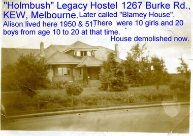 Melbourne Legacy
Document - Memoir, Wisdom Days
... from a child's point of view, The information and photographs ...As a teenager in the 1950s Alison Wisdom was a resident for seven years at both Stanhope and Holmbush Legacy hostels in Burke Road, Kew. She has compiled a website and written a book about her extended family in which her own experiences are described. Alison's brother, Stephen Kerry Wisdom, also lived at the hostels, as well as her eventual husband, Graeme Ball, and she describes their lives as Legacy children very fondly with many photographs.This is a rare and well researched account which describes the residences from a child's point of view, The information and photographs give a valuable insight into the running of the hostels, the lives of the beneficiaries and effect of the efforts of so many Legatees.1 x pdf document, colour and black & white 5.81 MB, 33 x jpeg images, colour and black & white. 56 - 1,938 KBmemoir, residences, junior legatee -
 Ballarat Tramway Museum
Slide - Set of 8, Warren Doubleday, Ballarat - last day of the Mt Pleasant line, 5/9/1971
Photos taken on the last day of the Mt Pleasant tram line 5/9/1971 1 - Tram 43 at the Gardens - trams reversed at this point and returned to Mt Pleasant. 2 - Trams 43, 13 and 14 in Sturt St West at the Russell St loop. 3 - Tram 13 in Sturt St, inbound with an ANZ bank and Miss Heidi? dress shop in the background. 4 - Tram 30 in bound in Sturt near Doveton St with the Queen Alexandra Bandstand in the view. 5 - A busy Sturt St with three trams and people observing on a nice day. 6 - and now with five trams at Tramway or the City Centre - trams 39, 27, 12 7 - Tram 43 pulls into the stop at Sturt and Lydiard St, 8 -Turning into Lydiard St North with 39 behind - a man with a point bar and possibly the Inspector as well. Behind are the Town Hall and the Myer store. Yields information about the last day of the Mt Pleasant tram line in Ballarat.Set of 7 Kodachrome colour slides - cardboard mountsHave the photographer's slide numbers written on them.trams, tramways, closure, lydiard st nth, sturt st, tram 27, tram 14, tram 13, tram 43, tram 39, tram 30, tram 12, sturt st west, russell st -
 Melbourne Tram Museum
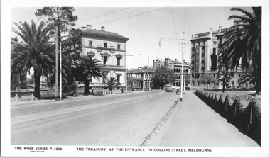
Postcard, Rose Stereograph Co, "The Treasury at the entrance to Collins Street, Melbourne", late 1940s
Rose Series postcard No. P 4232 titled "The Treasury at the entrance to Collins Street, Melbourne", looking south west along Macarthur Street towards the intersection of Spring and Collins Streets. Two W2 class trams are in the view, one running a route 13. A traffic policeman can be seen on point duty to the left of the tram.Yields information the intersection of Spring, Macarthur and Collins Streets and the then Treasury Building.Postcard - printed real photograph with Rose Stereograph Co. name on the rear. Two copies held.Has a hand written letter on the rear and the "K J Magor" stamp on the rear.tramways, trams, w2 class, spring st, collins st, macarthur st, treasury, route 13 -
 The 5th/6th Battalion Royal Victoria Regiment Historical Collection
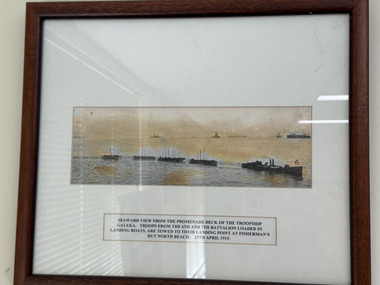
Photograph - A photograph of troops loaded in landing boats
A copy of a photograph with text explanation of "Seaward view from the promenade deck of the troopship galena. Troops from the 6th and 7th Battalion loaded in landing boats, are towed to their landing point at Fisherman's Hut North Beach. 25th April 1915". The photograph is in the glass wooden frame -
 Melbourne Tram Museum
Postcard, Rose Stereograph Co, "Swanston St south from Lonsdale St Melbourne", late 1920's
Rose Series postcard No. P 10531 titled "Swanston St south from Lonsdale St Melbourne". Trams in the view are W class No 337 (St Kilda Beach) with men standing on the footboard, and W Class No 350 (Coburg), both without route number boxes. There is an early MMTB bus heading south at Lt. Bourke Street intersection. On the left is the Worthmore Shore Store. A traffic policeman is on point duty. At least one horse-drawn vehicle is in the view along with a motorcycle with a side car.Yields information about Swanston St. at the intersection with Lonsdale St.Postcard - printed real photograph with Rose Stereograph Co. name on the rear. Unused.trams, tramways, swanston st, mmtb buses, w class, tram 337, tram 350, lonsdale st -
 Lakes Entrance Historical Society
Photograph - Housing, 1999
Known as Powerlot, built by George Packer, a local builder for Jim McLaughlin in 1914. During Olsen family ownership house was altered. The two acre site once had landscaped garden and orchard. Flat roof has lead lined walkway for viewing lakes and sea. Story goes 'The German raider Wolf was observed signalling during WW1'.Colour photograph of a white painted timber dwelling set on a high vantage point at Stirling Road consisting of two wings, one with flat roof and veranda on three sides, the other more recently built has hipped roof. Metung Victoriahouses, heritage study -
 University of Melbourne, Burnley Campus Archives
Photograph - Colour print, Administration Building, c. 1990
Colour photograph. Administration Building,. View of the entrance with three people walking down the steps. VCAH Burnley sign attached to the building. Part of sign pointing to Receptin.administration building, entrance, vcah, victorian college of agriculture and horticulture -
 Lakes Entrance Historical Society
Photograph - Lakes Entrance Grid location, 1999
Lakes Entrance Grid reference, Cunninghame 8522.3.4 896.082, on ten acre site with trig point, it is from this point that all the survey for the surrounding areas was undertaken. Part of the Vic Geodetic Survey initiated in 1860 by Ellery Survey started from triangulation base in Werribee. (Grid ref B'dale 8422)Colour photograph of the Victoria Geodetic Survey Triangulation Station, Trig Station, situated off Ocean View Parade, Merrangbaur Hill. Location is indicated by ground point and standing structure, situated on an elevated bush block. Lakes Entrance Victoriasurveying, township planning -
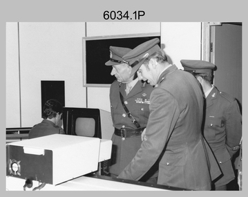 Bendigo Military Museum
Photograph - Visit by the Chief of the General Staff to the Army Survey Regiment, Fortuna, Bendigo, 1979
This is a set of 14 photographs of a visit to the Army Survey Regiment, Fortuna, Bendigo on the 5th of June 1979 by the Chief of the General Staff (CGS) Lieutenant General Sir Donald Dunstan AC, KBE, CB. He was accompanied by his wife. They were escorted through the production areas of the Army Survey Regiment by the CO LTCOL Bob Skitch. Lieutenant General Sir Donald Dunstan AC, KBE, CB was an esteemed Australian Army officer, who was CGS from 1977 to 1982. Upon retirement from the Army in 1982, he was appointed to the position of Governor of South Australia from 1982 to 1991. LTCOL Bob Skitch was the CO of the Army Svy Rgt from 1976 to 1980. Also featuring in these photos is MAJ Peter Eddy, who was the OC of Air Survey Squadron. He was later promoted to LTCOL and was CO of the Army Svy Rgt from 1981 to 1982. See item 6035.9P for photos of the CGS’s presentation of the Defence Force Service Medal to four recipients.This is a set of 14 photographs of a visit by the Chief of the General Staff to the Army Survey Regiment Fortuna, Bendigo on the 5th of June 1979. The photographs were printed on photographic paper and are part of the Army Survey Regiment’s Collection. They were scanned at 300 dpi. .1) - Photo, black and white, 1979. Tour of Air Survey Squadron. L to R: unidentified, LTGEN General Sir Donald Dunstan AC, KBE, CB; OC MAJ Peter Eddy, unidentified. .2) - Photo, black and white, 1979. Tour of Air Survey Squadron. LTGEN General Sir Donald Dunstan AC, KBE, CB; views 3D stereoscopic aerial photography on a Zeiss (Jena) Stecometer. OC MAJ Peter Eddy is on his right. .3) - Photo, black and white, 1979. Tour of Air Survey Squadron. L to R: unidentified, CO LTCOL Bob Skitch, OC MAJ Peter Eddy, LTGEN General Sir Donald Dunstan AC, KBE CB viewing an aerial photograph. WO1 Brian Mead and others are operating a Wild PUG4 point transfer device. .4) - Photo, black and white, 1979. Enlargement of photo .3). Tour of Air Survey Squadron. L to R: unidentified, CO LTCOL Bob Skitch, OC MAJ Peter Eddy, LTGEN General Sir Donald Dunstan AC, KBE CB viewing an aerial photograph. .5) - Photo, black and white, 1979. Tour of Air Survey Squadron. LTGEN General Sir Donald Dunstan AC, KBE, CB; and unidentified technician view 3D stereoscopic aerial photography on a Wild B8 stereo plotter. .6) - Photo, black and white, 1979. Tour of Air Survey Squadron. L to R: OC MAJ Peter Eddy LTGEN General Sir Donald Dunstan AC, KBE CB; CO LTCOL Bob Skitch, view the output of a verification plot on an AUTOMAP 1 Gerber 1442 drum plotter. .7) - Photo, black and white, 1979. Tour of Air Survey Squadron. L to R: CO LTCOL Bob Skitch, unidentified aide de camp officer, LTGEN General Sir Donald Dunstan AC, KBE CB; OC MAJ Peter Eddy discuss aero triangulation planning documents. CAPT Don Maskew in background. .8) - Photo, black and white, 1979. Tour of Cartographic Squadron. L to R: CPL Dennis Learmonth, acting OC CAPT Bob Roche, CAPT Eddy Schulze, LTGEN General Sir Donald Dunstan AC, KBE CB; SSGT John ‘JB’ Barrie discuss cartographic map compilation procedures .9) - Photo, black and white, 1979. Tour of Cartographic Squadron. L to R: Tech WO WO1 Roger Rix, acting OC CAPT Bob Roche, CAPT Eddy Schulze, unidentified visitor, Mrs Dunstan with examples of map products. .10) - Photo, black and white, 1979. Tour of Cartographic Squadron. L to R: CPL Terry Danger, CO LTCOL Bob Skitch, LTGEN General Sir Donald Dunstan AC, KBE CB; discuss terrain embossing (hill shading) procedures. .11) - Photo, black and white, 1979. Tour of Cartographic Squadron. L to R: CO LTCOL Bob Skitch, LTGEN General Sir Donald Dunstan AC, KBE CB; acting OC CAPT Bob Roche, SSGT Dick Manley, CAPT Don Maskew and CAPT Steve Cooper in background. SPR Cheryl Lofthouse is retouching blemishes on a map separation film negative. .12) - Photo, black and white, 1979. Tour of Lithographic Squadron. L to R: CAPT Stan Vote, unidentified aide de camp officer, CO LTCOL Bob Skitch, LTGEN General Sir Donald Dunstan AC, KBE CB; MAJ Sam Schwartz EXCH-US, LT John Harrison discuss bulk map printing processes with an Ultra-MAN-III Printing Press. .13) - Photo, black and white, 1979. Officers Mess L to R: LTGEN General Sir Donald Dunstan AC, KBE CB; with CO LTCOL Bob Skitch. .14) - Photo, black and white, 1979. Officers Mess L to R: MAJ Peter Eddy, LTGEN General Sir Donald Dunstan AC, KBE CB..1P to .14P – no annotationsroyal australian survey corps, rasvy, army survey regiment, army svy regt, fortuna, asr -
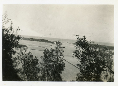
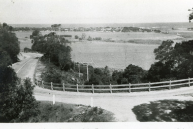 Lakes Entrance Historical Society
Postcard, Bulmer H D, 1950c
Also one other postcard same donated by M & V Carpenter in spares box.Black and white postcard of the Princes Highway Jemmys Point, showing Bullock Island between North Arm and Cunninghame Arm, distant view of the entrance from Bass Strait to the Gippsland Lakes. Post and rail fence along roadside. Lakes Entrance VictoriaPrinces Highway and a view of the Entrance vegetation, roads and streets -
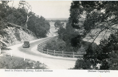 Lakes Entrance Historical Society
Postcard - Princes Highway Kalimna, Bulmer H D, 1935c
Black and white postcard of the Princes Highway as it winds around Jemmys Point. A motor car driving up the hill between steep road cutting and post and rail fence. View of the lake and ocean in the distance. Lakes Entrance VictoriaBend in Princes Highway, Lakes Entrance fences, roads and streets -
 Lakes Entrance Historical Society
Photograph - Carpentertown, Silver Reflections Studio, 1924c
Black and white photograph showing view of New Works. Village on dunes at entrance to Gippsland Lakes from ocean - Bass Strait. View shows SS Gippsland at New Works wharf, Cunninghame Arm, part of Bullock Island and mouth of North Arm, post and rail fence along roadway down Jemmys Point. Lakes Entrance Victoriawaterways, islands, settlement -
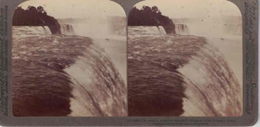 Linton and District Historical Society Inc
Stereograph, Underwood & Underwood Publishers, New York, London, Toronto Canada, Ottawa Kansas, Niagara Falls, Copyright 1904
One of two sets of stereographs donated by the O'Beirne family along with a stereoscope for viewing (Stereoscope is Registration no. 2014-51).Stereograph of two black and white images. Images show water cascading over a bank.(73)-5430 - The world's grandest waterfall - Niagara, from Prospect Point.stereographs -
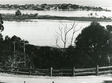
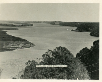 Lakes Entrance Historical Society
Postcard - Reeves Channel, Valentine Series, 1930c
Other copy similar view with inscription 'The Lakes, Lakes Entrance Vic'Black and white postcard of Reeves Channel Gippsland Lakes, showing Rigby, Fraser and Flannagan Islands opposite the steep shoreline of the mainland. Natural vegetation of Jemmys Point in foreground from which photograph was taken. Lakes Entrance VictoriaKalimna from Jemmys Point Lakes Entranceislands, waterways, topography -
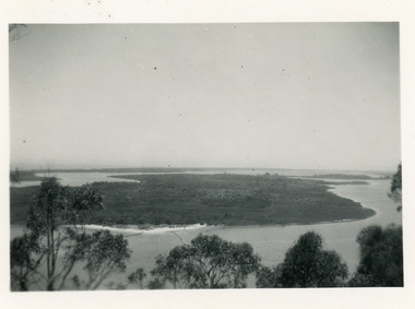 Lakes Entrance Historical Society
Photograph - Rigby Island, 1930c
Second copy similar viewBlack and white photograph of Rigby Island, Gippsland Lakes Victoria. It shows Reeves Channel on right of photo, Hopetoun Channel on left, The Narrows below Jemmys Point from which photo was taken. Lakes Entrance Victoriaislands, waterways, topography -
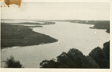 Lakes Entrance Historical Society
Photograph - Lake King, 1950c
Also copy of same view, stained, 9 x 14Black and white photograph of the Narrows and Reeves Channel of Lake King, Gippsland Lakes. It shows Rigby, Fraser, and Flannagan Islands opposite the steep shoreline of the mainland. Taken from Jemmy's Point, it shows a recently built groyne from Rigby Island into the Narrows. Lakes Entrance Victoriaislands, waterways, topography -
 Lakes Entrance Historical Society
Postcard - The Entrance, 1935c
Also small format identical postcard 6.5 x 8.5, very faded,|also small format photo, same view donated by D & M FletcherBlack and white small format postcard of the man made entrance to the Gippsland Lakes, taken from Jemmys Point. It shows the rock groynes beside Bullock Island, a barge in North Arm below Jemmys Point. Lakes Entrance VictoriaThe Entrance to Gippsland Lakes waterways, topography -
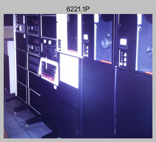 Bendigo Military Museum
Photograph - Aerotriangulation Production – Army Survey Regiment, Fortuna, Bendigo, c1970s to 1980s
This collection of 14 photos was most likely taken in the 1970s and 1980s in Air Survey Squadron. The PDP 11/70 minicomputer shown in photo .1P was the operating system introduced in 1977 as the mainframe system for the control of the APC4, aerial triangulation block adjustments, SORA OP Analytical Orthophoto control, APR Analytical Terrain Profile Recorder computation, graphics, and general computing. Technicians used the Wild A9 Stereocomparator shown in photo .2P to accurately measure between pass, tie, and survey control points on aerial photographs. The Zeiss D2 Planimat Stereoplotter shown in photos .3P to .4P was used for analytical orthophoto control. It was introduced in 1972-1973 The Zeiss (Jena) Stecometer analytic stereocomparator for air photography shown in photos .5P to .11P and .14P was introduced at Air Survey Squadron in 1963. Aerotriangulation production was expedited using computers for analytical photogrammetric processes. The technician accurately measured between pass, tie, and survey control points on aerial photographs. Wild PUG4 point transfer devices shown in photos .12P to .13P were introduced in c1968 superseding the PUG2 devices. PUG4 devices were used by technicians to stereoscopically view the photography containing the survey control points and the mapping aerial photography. The Control points were transferred from the control photography to the mapping diapositives of aerial photography by drilling their locations into the photographic emulsion.This is a set of 14 photographs of Air Survey Squadron personnel operating aerotriangulation equipment at the Army Survey Regiment at Fortuna, Bendigo, c1970s to 1980s. Photographs .1P to .13P were on 35mm colour slide film and scanned at 96 dpi. Photograph.14P was printed on photographic paper and was scanned at 300 dpi. They are part of the Army Survey Regiment’s Collection. .1) - Photo, colour, c1979, PDP-11 minicomputer. .2) - Photo, colour, c1970s, Unidentified technician operating a Wild A9 Stereocomparator. .3) - Photo, colour, c1970s, Zeiss D2 Planimat Stereoplotter. .4) - Photo, colour, c1970s, Zeiss D2 Planimat Stereoplotter, unidentified technicians. .5) - Photo, colour, c1970s, Zeiss D2 Planimat Stereoplotter, SGT Christopher Wardley. .6) - Photo, colour, c1970s, Zeiss D2 Planimat Stereoplotter. .7) to.9) - Photo, colour, c1970, Zeiss (Jena) Stecometer, unidentified technicians. .10) to.11) - Photo, colour, c1988, SPR Toni Wright operating a Zeiss (Jena) Stecometer. .12) - Photo, colour, c1970s, Wild PUG4 point transfer device, SPR John Shepard. .13) - Photo, colour, c1970s, Wild PUG4 point transfer device, SPR David Edwards. .13) - Photo, colour, c1970s, Wild PUG4 point transfer device, SPR David Edwards. .14) - Photo, colour, c1980, Zeiss (Jena) Stecometer, SGT Bruce Hammond.Some of the equipment is annotated on the frame of the 35mm slides.royal australian survey corps, rasvy, army survey regiment, army svy regt, fortuna, asr, aerotrig, photogrammetry -
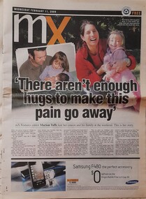 Hymettus Cottage & Garden Ballarat
Newspaper - MX, There aren't enough hugs to make this pain go away
... on a third party, a point of view differing from immediate families ...Marion Taffe was Features Editor for Melbourne's MX commuter newspaper and wrote this feature following the loss of her cousin and family at Kinglake in Victoria's Black Saturday bushfires of 2009. Her article was published in newspapers worldwide.non-fictionMarion Taffe was Features Editor for Melbourne's MX commuter newspaper and wrote this feature following the loss of her cousin and family at Kinglake in Victoria's Black Saturday bushfires of 2009. Her article was published in newspapers worldwide.bushfire, black saturday bushfires, victorian bushfires, kinglake, warnambool, marion taffe, mx, newspaper, davey family -
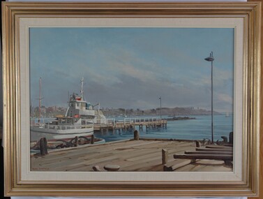 Glenelg Shire Council Cultural Collection
Painting, Whalers Point from Harbour Trust Dock, n.d
Port of Portland CollectionView of harbour and jetties from a dock. Dock is in foreground. A white fishing vessel is berthed at a jetty positioned near the dock. In background is a view of the foreshore with buildings. The water is pale blue with darker blue details. The sky is blue with grey wash depicting clouds near horizon line. Mounted in thick cream canvas mount, framed under glass in wooden gold painted frame.Front: Signature - Ramon Horsfield (lower left) (orange paint). Back: (no inscription)port of portland -
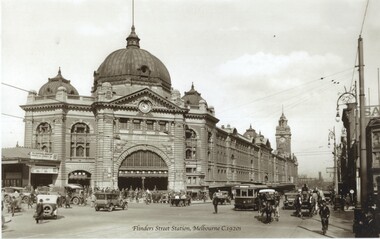 Melbourne Tram Museum
Photograph - Black and white - Flinders St Station c1920's
Shows H class tram number 57, east bound in Flinders St with the Flinders Street Railway station in the background. Has a number of horse drawn vehicles in the view along with motor cars and trucks, some of them doing a hook turn. A policeman is on point duty. Photo taken after Flinders St converted to electric trams from cable trams in 1927. Commercial print from a SLV photo.Yields information about the location, the streetscape and the trams and vehicles in use at the time. Original photo taken from a Rose Series - Southern Cross Series No. 5. See State Library of Victorian Collection - H2011.27DBlack and white photograph of Flinders St Station Melbourne, late 1920's with H class tram 57 in the view."RSCP 327" & "C1929" in pencil and "H57" in red ink on rear.tramways, h class, trams, tram 57, flinders st, flinders st station, horse drawn vehicles, mmtb