Showing 15082 items matching " views"
-
 Kew Historical Society Inc
Photograph, J F C Farquhar, A View in Studley Park Road, 1891
At the beginning of the 1890s, the Kew businessman and Town Councillor, Henry Kellett, commissioned J.F.C. Farquhar to photograph scenes of Kew. These scenes included panoramas as well as pastoral scenes. The resulting set of twelve photographs was assembled in an album, Kew Where We Live, from which customers could select images for purchase.The preamble to the album describes that the photographs used the ‘argentic bromide’ process, now more commonly known as the gelatine silver process. This form of dry plate photography allowed for the negatives to be kept for weeks before processing, hence its value in landscape photography. The resulting images were considered to be finely grained and everlasting. Evidence of the success of Henry Kellett’s venture can be seen today, in that some of the photographs are held in national collections.It is believed that the Kew Historical Society’s copy of the Kellett album is unique and that the photographs in the book were the first copies taken from the original plates. It is the first and most important series of images produced about Kew. The individual images have proved essential in identifying buildings and places of heritage value in the district.This is the earliest known photograph of the exterior of Byram (later Tara Hall). It shows the original red brick fence, its asymmetrical gate and gateposts, with a large terra cotta gargoyle surmounting the higher of the two. The architect, Edward Kilburn designed Byram in the Arts & Crafts style for the industrialist George Ramsden. Construction began in 1888 and was reputed to have lasted three years. The mansion had frontages to Studley Park Road and Stevenson Street, including gardens laid out with great taste, including pleasure grounds, tennis lawn, fruit and flower garden, and paddock. The size of many of the trees in the garden indicate that many survived from the garden of Clifton Villa, the previous single-storeyed house built on the site by the Stevenson brothers. Byram had views to Melbourne and Port Phillip Bay. The house was demolished in 1960, despite opposition from the National Trust (Victoria), and its gardens subdivided into residential allotments.A View in Studley Park Roadkew illustrated, kew where we live, photographic books, henry kellett, byram, tara hall, goathlands -
 Phillip Island and District Historical Society Inc.
Photograph, circa 1900
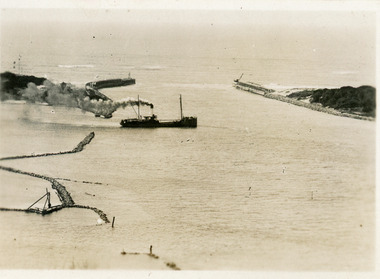
The first Punt under construction at Newhaven. Charlie Newman and wife with unknown man with bandaged arm. Across the water is view of San Remo township. Overhanging ??Close-up of Punt in San Remo waters. Background view of San Remo township.local history, photography, photographs, slides, film, the first punt, san remo punt, black & white photograph, miss elms san remo -
 Lakes Entrance Historical Society
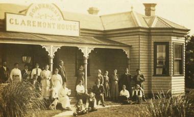
Postcard - Claremont House, 1922 c
Also two postcards showing two views of Claremont House with visitors on verandah 1925 c 05266.2 Added is back of 05266.1 is a message to Aunt Lizzie.Black and white postcard of front view of Roadknight's Claremont House Lakes Entrance VictoriaMalcolm Fallshaw 462 Canterbury Rd Punchbowl on backguesthouses, tourism, correspondence -
![High Street, East Kew [looking west], 1977](/media/collectors/550653872162f11fb04854aa/items/586f8bbfd0ce0e07f06d22ed/item-media/586f8c3ad0ce0e07f06d44cc/item-fit-380x285.jpg) Kew Historical Society Inc
Kew Historical Society IncPhotograph, High Street, East Kew, 1977
The Kew Historical Society's Pictures Collection is comprised of photographs and original works of art. The photographs include original (mainly) images dating from the 1870s to the present. A number of these photographs derive from the former City of Kew's Civic Collection while others are the work of amateur and professional photographers. Most of the images in the collection depict people, places and objects within the suburbs of Kew and Kew East. Other photographs depict other locations in Melbourne and Victoria. A number of the photographs are of statewide and/or national significance.View from junction of High and Strathalbyn Sts., Kew East, looking approximately west toward Cemetery, October 1977. Inscription reverse: "KH-72. View from junction of High St. & Strathalbyn Sts, Kew E. Looking approx. west, towards Cemetery. October 1977."high street -- kew (vic.), streetscapes -- kew (vic.) -
 Stawell Historical Society Inc
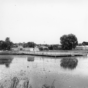
Photograph, Cato Lake with the Pool & Entrance in Florence Street c 1974 -- 4 Photos
Four B/W photos taken in 1974 showing various views of the Olympic Pool. One the entrance to the pool at Florence Street. Another the view of the pool across Cato Lake from Napier St. There is also an enlarged print of the view across Cato Lake. The final two photographs show the Olympic pool and wading pool with one under construction and the other the pool completed and a child in the wading pool.Four Black & white photos taken in 1974. One photo shows the Olympic Pool entrance, Florence St. Another the view of the pool from across Cato Lake from Napier St. The other two photos are similar views of the Olympic pool. One the pool under construction pre 1958 showing construction of the wading pool and form work under the main pool. The final 4th photo the completed pool with a child in the wading pool. Included also included in the file is an enlarge print of the view across the lake from Napier St.stawell -
 Lakes Entrance Historical Society
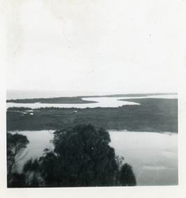
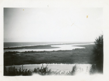
Photograph - Rigby Island, 1950c
Two other copies 6 x 9 (one - slightly different view)Small format photograph of view from Kalimna across Rigby Island to back lakes near Lakes Entrance, Victoriaislands, waterways, topography -
 Lakes Entrance Historical Society
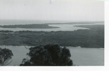
Photograph - Rigby Island, 1950c
Two other copies 6 x 9 (one - slightly different view)Small format photograph of view from Kalimna across Rigby Island to back lakes near Lakes Entrance, Victoriaislands, waterways, topography -
 Lakes Entrance Historical Society
Photograph - Rigby Island, 1950c
Two other copies 6 x 9 (one - slightly different view)Small format photograph of view from Kalimna across Rigby Island to back lakes near Lakes Entrance, Victoriaislands, waterways, topography -
 Surrey Hills Historical Society Collection
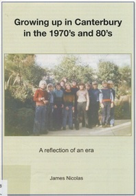
Book, Growing up in Canterbury in the 1970s and 80s:a reflection of an era, 2015
This is a recollection of what was one person's view on growing up in Willandra Avenue, Canterbury and the surrounding area.This is a recollection of what was one person's view on growing up in Willandra Avenue, Canterbury and the surrounding area.|20 pages(mr) james nicolas, childhood and youth, canterbury, willandra avenue, scouts, (mrs) betty ballantyne, (mr) - hawkens, (mrs) - hawkens, (mrs) - thomas, (mr) phillip anderson, kranjcics family, (mr) john proper, (dr) (mr) - barton, (mr) - phillips, (mr) - goff, (mrs) - mcmillan, (mr) - mceroy, (miss) caroline harris, (mr) - ielpo, (mr) graeme brent, (mr) peter brent, (mrs) tuyet brent, buckingham family, (mrs) - proper, billings family, howats family, canterbury football club, (mr) jim shepherd, (mrs) lillian shepherd, tulloch begg, house names, salvation army, (mr) (dr) alan williams, dentists, doctors, malone's hotel, canterbury mansions, (mr)(father) - potter, (mrs) - kerr, (mr) - kerr, canterbury cricket club, the gunyah, (mr) jim richards, (mr) "rainbow" simpson, canterbury football club, (mr)(cr) - maling, (sir) (mr) aaron danks, logan family, hasset family, staig family, (mr) tony petroro, outer circle, canterbury presbyterian church, bradshaw's mechanic, (mr) francis bourke, emulation hall, (mr) - cameron, (mr) - lathan, canterbury primary school, vozzo's milk bar, camberwell high school, (mr) - de munk, (mr) - howie, (miss) - patterson, (mr) - collins, (miss) kylie minogue, (mr) craig mcdonnell, (mr) dean mcdonnell, (miss) danni minogue, (mr) jack) morris, (mrs) marjorie rowe, (mr) andrew rowe, (mr) peter rowe, (mr) richard rowe, (mr) richard rowe, (mr) frank kelly, gagliardi family, (mr) phillip graham, mcdonnell family, sutherland family, toddle inn, rooney's butcher -
 Ballarat Tramway Museum
Photograph - Black & White Photograph/s, Jim Seletto, early 1960's
Yields information about the appearance of Ripon St during the early 1960's and how it related to the View Point line.Black and white photograph of Ballarat No. 21 north bound to View Point in Ripon Street, early 1960's. Tram has the destination of View Point and a White Horse Whiskey advertisement on the front dash panel.On rear stamp "Photographed by J. Seletto" and in blue ink "Tree Line View Point Line 1968" (The date is post 1964 - after the large white stripe added to the driver's dash panels of all Ballarat trams.)tramways, trams, view point, ripon st, tram 21 -
Glenelg Shire Council Cultural Collection
Postcard - Postcard, n.d
Black and white photo postcard. View across Hanlon Park Portland. Horse and cart, several children in foreground, another on right, group of people in backgroundFront: '(SECTION ?CKD.3)' GENORA & VIEW OF 'THE WORKING BEE', HANLON PARK, PORTLAND. TOYE PHOTO' - white script bottom edge -
 National Wool Museum
Document - Grazcos Annual Report, Grazcos Co-operative Limited, 1953
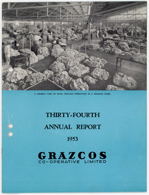
The co-operative was registered in 1919 as the Graziers Co-op Shearing Company Limited. It changed its name in September 1948 to Grazcos Co-operative Ltd. In 1981 the co-operative merged with Farmers & Graziers Co-op Ltd to form Farmers Grazcos Co-op Ltd. This item is part of a collection of Annual Reports from Grazcos dated from 1949 - 1980.Booklet featuring a black and white image showing an internal view of a factory with working processing wool , with printed black text on blue background below image.front: A GENERAL VIEW OF WOOL POOLING OPERATIONS IN A GRAZCOS STORE / THIRTY-FOURTH / ANNUAL REPORT / 1953 / GRAZCOS / CO-OPERATIVE LIMITEDagricultural co-operative, agricultural wholesaling, annual reports, rural life, rural industry, business, corporate body -
 Lakes Entrance Historical Society
Postcard - SS Despatch, c1910
Second copy same viewSmall format postcard showing coastal steamer SS Despatch leaving Cunninghame Arm, with entrance piers and rock groynes in view. Lakes Entrance VictoriaThe Piers from the lookout at Jemmys Point (on back)jetties, topography, ships and shipping -
Glenelg Shire Council Cultural Collection
Photograph - Photograph - Killara Bridge over Glenelg River, c. 1963
Sourced from Casterton Town Hall (former Shire of Glenelg)Black and white photo. View of Killara Bridge over Glenelg RiverFront: Black stamp - 003635 Back: 'View of Killara Bridge over Glenelg River' - handwritten in pencil. Blue biro line arrowed both ends, drawn across width of photo. 3" in blue biro written above line -
 Tatura Irrigation & Wartime Camps Museum
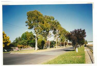
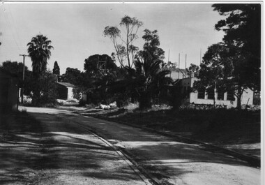
Photograph, Casey Street Tatura
Shows picture of the view looking west along Casey Street, Tatura. Colour photograph showing view looking west along Casey Street, Tatura. Photograph stuck onto piece of white cardboard. tatura victoria, casey street tatura -
University of Melbourne, Burnley Campus Archives
Album - Colour slides, Overseas Travel 1976, 1976
... views ...Approximately 300 slides of Canadian sights. Labelled but out of order. In plastic compartmentalised box. Not scanned.canada, views -
 Stawell Historical Society Inc
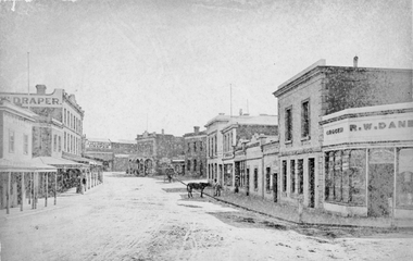
Photograph, Main Street Stawell looking West from Layzell Street 1878
1878 photo of Main St. Scenes looking West from Layzell St. Wooden building on left is Foresters Hotel on corner of Patrick Street. D. Fern Hotel / Times Office, McKeller Building with Draper sign. Across Main street from left in distance is J Allingham Draper, Chadwick & Co Drapers / Liddiard's , D. Telford Produce Grocer, Bank of Victoria, Oriental Bank / O'Driscoll's, J. Punchard Furniture, A.B. Clemes, Bennett & Briston, Union Bank Australia, R.W, Dane Grocer on corner of Layzell Street. Same view as 6730-2 0539-2 Victorian Views. C. Herbert, Photo. Stawell 1878stawell businesses streetscape -
 Ballarat Tramway Museum
Photograph - Black & White Photograph/s, Jim Seletto, early 1960's
Yields information about the appearance of Wendouree Parade during the early 1960's and how it related to the View Point line.Black and white photograph of Ballarat No. 21 north bound to View Point in Wendouree Parade, early 1960's. Tram has the destination of View Point and a White Horse Whiskey advertisement on the front dash panel.On rear stamp "Photographed by J. Seletto" and in blue ink "S Truck 21 View Point Line 1968" (The date is post 1964 - after the large white stripe added to the driver's dash panels of all Ballarat trams.)tramways, trams, wendouree parade, view point, tram 21 -
 Melbourne Legacy
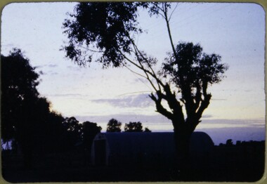
Slide, Operation Firewood, 1960s
Colour slide of a tree silhouetted against a sunset. It was during Operation Firewood. Legatees would organise collection of wood from the country and distribute it to widows in metropolitan Melbourne. Other slides show the cutting and loading of wood and delivery to widows in metropolitan Melbourne. Was with many other slides taken in the 1950s and 1960s. The slides have been photographed to make digital images and moved to archive quality sleeves. In many cases the original images were not well focussed and the digital image the best available.A record of Legacy helping widows by sourcing, supplying and delivering firewood. When open fires were the main source of heating, a load of firewood and help moving it, would have been very important to the widows.Colour slide of a view of a sunset during Operation Firewood in brown Anscochrome cardboard mount.Printed on front in red ink 'Anscochrome / View from this side / Made in Australia'. Hand written on front 'Firewood' in blue pen. Printed on reverse in red ink 'Processed by Verycolor photo labs. Melbourne, Victoria'.operation firewood, trees -
 Warrnambool and District Historical Society Inc.
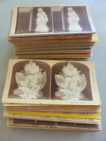
Photograph - Stereoscope photographs, Collection of stereoscope cards, Late 19th century – early 20th century
The international cards depict a range of view of items such as nature shots of America to photos of abbeys and cathedrals in Europe and views in England Scotland and Ireland. The views in Australia are a similar eclectic mix from shots of the Melbourne cemetery to images of statues in the Ballarat gardens. By placing the card with two images of the same subject, in the stereoscope, it provided a three dimensional view of the photo.Provides a snapshot of general interest items and views of early Australia and Australians.A collection of 76 cards with various scenes and topics. Each card displays two photos of the same view or item on various coloured card backgrounds. There is a mixture of sepia Black and white and coloured photographs.A number of the cards with international scenes have typed on the reverse “Photographed and published by Kilburn Brothers Littleton N.H. Others depicting scenes in Australia are stamped Theodor Bloch. warrnambool, stereoscope, stereoscope photographs -
 Marysville & District Historical Society
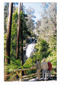
Photograph (item) - Colour photograph, September 2008
A colour photograph of three men standing at the viewing platform looking at Steavenson Falls in Marysville in Victoria.A colour photograph of three men standing at the viewing platform looking at Steavenson Falls in Marysville in Victoria. This infrastructure was destroyed in the 2009 Black Saturday bushfires. The Steavenson Falls is named after the Victorian Assistant Commissioner of Roads and Bridges, John Steavenson who arrived in Victoria in the early 1860s.September 2008steavenson falls, waterfalls, marysville, victoria, john steavenson, 2009 black saturday bushfires -
 Ballarat Tramway Museum
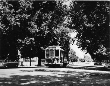
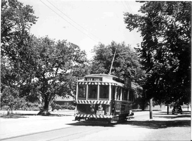
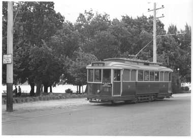
Photograph - Ballarat tram 18 - Lake View, Ken Winney, 12/1949
The photograph shows SEC Ballarat tram No. 18 in Wendouree Parade at a location opposite the View Point Hotel. The "gazebo" at this location can be seen behind the tram. The tram has the destination of View Point and an auxiliary sign of "Lake View Point Only - connect with launches". On the left side of the photo is a highway advisory sign "Motorists Drive Slowly" Photo by I K Winney of Sydney, 12/1949.Yields information about tram 18 and the Lake View route.Black and white photograph with photographers details on rear."No. 18 at View Point terminus, note supplementary sing re ferry connection across Lake Wendouree, Ballarat, 12/1949, I K Winney"tramcars, tram 18, wendouree parade, lake view, road signs -
 Port Melbourne Historical & Preservation Society
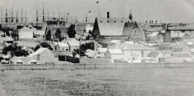
Photograph - View of Port Melbourne, c.1890
.The view of Port Melbourne looking towards the sailing ships moored at Railway Pier is believed to have been taken from the Fire Tower off Liardet Street. Swallow's chimney can be seen behind the Graham Street Methodist church. This photograph is a part of a wider view of an original photograph taken for International Exhibition of 1873.View of Port Melbourne looking towards Town Pier with Swallow 's chimney behind the Graham Street Methodist Church.On back Methodist Church Graham Street Swallow's Chimney in Back groundreligion - methodist church graham street, swallow & ariell ltd, fire tower -
 Charlton Golden Grains Museum Inc
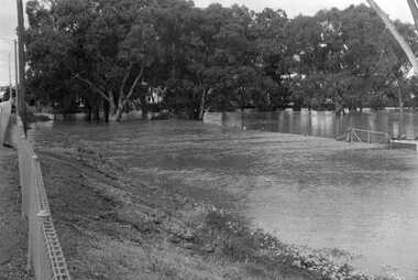
Photograph, Cameron, Ian, 1973 flooded Avoca River, Feb 19873
1973 flooded Avoca River. Viewed from west side of Paterson Bridge behind the shire office.B/W photograph of 1973 flooded Avoca River. View West side of Paterson Bridge behind Shire Officeflood, avoca river, charlton -
 University of Melbourne, Burnley Campus Archives
Photograph - Black and white print, Administration Building Under Construction, 1946-1947
Note by T.H. Kneen 20 February 1991, "View of new building under construction 1946/47. Building on left is Contractor's hut (Anderson of Ivanhoe) (Mr. Tom(?) Floyd foreman.) Road leads up to old point of entry to the gardens which enclosed the Pavilion, partially demolished at this stage."Black and white photograph. View of new building under constructiontom floyd, pavilion, anderson of ivanhoe, administration building, builder -
 Marysville & District Historical Society
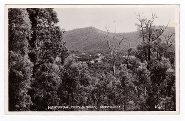
Postcard (item) - Black and white postcard, Valentine Publishing Co. Pty. Ltd, View From Jock's Lookout, Marysville. V. 21, 1923-1963
An early black and white photograph of the view from Jock's Lookout of Marysville in Victoria. An early black and white photograph of the view from Jock's Lookout of Marysville in Victoria. Jock's Lookout is situated on the Marysville-Wood's Point Road. The Marysville-Woods Point Road was originally part of the Yarra Track, constructed in the early 1860s to provide access between Healesville and the Woods Point Goldfields. Despite the steep terrain and engineering difficulties, the Yarra Track soon became a busy route used by pack horses, horse-drawn drays, and wagons. Today this sealed mountain road is a popular scenic drive between Marysville and Warburton. This postcard was published by the Valentine Publishing Co. Pty. Ltd. as a souvenir of Marysville.VALENTINE'S/ POST CARD/ A GENUINE PHOTOGRAPHjock's lookout, marysville, victoria, postcard, valentine publishing co, souvenir, marysville-wood's point road, yarra track, mining, warburton -
 Marysville & District Historical Society
Postcard (item) - Black and white postcard, Valentine Publishing Co. Pty. Ltd, View From Jock's Lookout, Marysville. V. 21, 1923-1963
An early black and white photograph of the view from Jock's Lookout of Marysville in Victoria.An early black and white photograph of the view from Jock's Lookout of Marysville in Victoria. Jock's Lookout is situated on the Marysville-Wood's Point Road. The Marysville-Woods Point Road was originally part of the Yarra Track, constructed in the early 1860s to provide access between Healesville and the Woods Point Goldfields. Despite the steep terrain and engineering difficulties, the Yarra Track soon became a busy route used by pack horses, horse-drawn drays, and wagons. Today this sealed mountain road is a popular scenic drive between Marysville and Warburton. This postcard was published by the Valentine Publishing Co. Pty. Ltd. as a souvenir of Marysville.VALENTINE'S/ POST CARD/ A GENUINE PHOTOGRAPHjock's lookout, marysville, victoria, postcard, valentine publishing co, souvenir, marysville-wood's point road, yarra track, mining, warburton -
 Kew Historical Society Inc
Photograph, J F C Farquhar, Bird's Eye View Looking West, 1891
At the beginning of the 1890s, the Kew businessman and Town Councillor, Henry Kellett, commissioned J.F.C. Farquhar to photograph scenes of Kew. These scenes included panoramas as well as pastoral scenes. The resulting set of twelve photographs was assembled in an album, Kew Where We Live, from which customers could select images for purchase.The preamble to the album describes that the photographs used the ‘argentic bromide’ process, now more commonly known as the gelatine silver process. This form of dry plate photography allowed for the negatives to be kept for weeks before processing, hence its value in landscape photography. The resulting images were considered to be finely grained and everlasting. Evidence of the success of Henry Kellett’s venture can be seen today, in that some of the photographs are held in national collections.It is believed that the Kew Historical Society’s copy of the Kellett album is unique and that the photographs in the book were the first copies taken from the original plates. It is the first and most important series of images produced about Kew. The individual images have proved essential in identifying buildings and places of heritage value in the district.Before true aerial photography became possible, photographers such as J.F.C. Farquhar were compelled to shoot their images from the highest vantage point. Here, it is presumed to be the roof of Xavier College, from which the panoramic view extends west towards the rise of Studley Park. The houses in the foreground face the southern end of Gellibrand Street. Wellington Street is at an angle to the camera with the Queen Street intersection on the near right. The wooden building behind the large horse paddock on the other side of Gellibrand Street is the Kew Recreation Hall, built 1888, demolished 1960. It was reputed to have one of the finest dancing floors in or around Melbourne. The Bowling Green at the rear of the Hall belonged to the Kew Bowling Club. Further west is the Kew Railway Station on Denmark Street, opened to the public in 1887. At this period, much of Studley Park was locked up in large landholdings, dominated by large mansions such as ‘Byram’. Bird's Eye View Looking Westkew illustrated, kew where we live, photographic books, henry kellett, denmark street, kew recreation hall, kew bowling club, wellington street -
 Port Fairy Historical Society Museum and Archives
Photograph - Postcard, Wm. Thompson
Port Fairy views - gardens, river, beachMontage of 5 Photographs headed with a large flourishing banner announcing Greetings from Port Fairy (postcard)published by Wm.Thompson Port Fairy- Greetings from Port fairy,View in the gardens Port fairy ,Government wharf Port Fairy Bathing boxes Port Fairygardens, river, beach, crags, botanical gardens, bathing boxes, battery hill, wharf, government wharf, moyne river, port fairy -
 Stawell Historical Society Inc
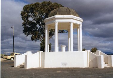
Photograph, Pioneers’ Memorial and Plaques on Big Hill --3 Photos -- Coloured
Three colour photographs, one view of Pioneers Memorial and two of the stone plaques. The memorial photo looks freshly painted. The plaques illustrate that the foundation stone was laid by Lord Huntingfield in c 1935 while the other plaque is dedicated to the Pioneers of Stawell and Districts in c 1938. Three colour photographs, one view of Pioneers Memorial and two of the stone plaques. The view of the memorial looks crisp and clear with a dark cloudy background. A Ute is parked in the background beside the light post. "Stawell Gold mines" on the back of the 3 photographs. Wording on plaques "This Foundation Stone was laid by HIS EXCELLENCY LORD HUNTINGFIELD, K.C.M.G. Governor of Victoria October 7th, 1935. The second plaque "Dedicated to the Pioneers of Stawell and District by HIS EXCELLENCY SIR FREDERICK WOLLASTON MANN K.C.M.G. Lieut Governor of Victoria. August 6th, 1938.stawell