Showing 2047 items
matching building and construction
-
 Kew Historical Society Inc
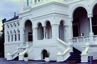
Slide - 'Burke Hall', Nolan Avenue, 1976
Colour transparency (slide) created in June 1976 during a tour by the Junior National Trust, which was led by members of Kew Historical Society. The collection of 21 slides reveals that the tour covered all parts of Kew, but focused understandably on heritage buildings and sites.Image of an historic place in Kew that can be dated to an exact time and place. The images, albeit amateurish in composition, frequently reveal aspects of important buildings and sites that have changed over time.35mm colour transparency of the front portico of Burke Hall (formerly Studley Hall, Waverley) and now Xavier Junior School in Nolan Avenue, Kew. Since its construction in the 19th century, the building has had numerous additions made by subsequent owners. The original render has been painted and sections of the original colonnades glazed in. The facade of Burke Hall faces away from Studley Park Road to take advantage of the views to the south.historic houses -- kew (vic), xavier college -- kew (vic.), burke hall -- kew (vic.), waverley -- kew (vic.), nolan avenue -- kew (vic.), studley hall -- kew (vic.) -
 Uniting Church Archives - Synod of Victoria
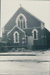
Photograph, undated
The memorial stone of the UMFC in Church St. Richmond was laid in December 1868. The bluestone church, which seated 308 people, was designed by G.R. Cox and built by John Wright. It was opened in May 1869. By 1890 subsidence in the foundations of the building had caused the bluestone façade to bulge dangerously outwards and a new façade of red and white brick was constructed. The memorial stone of the new façade was laid on 7th June 1890. Before construction of the 1868 church, services were held in a weatherboard building which subsequently served as the Sunday School.B & W photograph of the exterior of the Richmond United Free Methodist Church.united free methodist church, church street richmond, bluestone, g.r. cox, john wright. -
 Kiewa Valley Historical Society
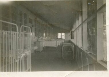
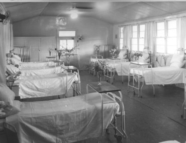
Photo - Tawonga Hospital, 1950
The original Tawonga District Hospital was situated at the corner of Ryders Lane and Kiewa Valley Highway. The construction was initiated by the Hospital and Charities Commission with considerable assistance from the SEC. The building was transported from Bonegilla where it was originally part of the Bonegilla Military Hospital. It was officially opened on September 24, 1949. Prior to this anyone needing hospitalisation had to travel to Yackandandah.First hospital in the Kiewa Valley in 1949. Serving the Upper Kiewa communityBlack and white photograph of hospital ward in the original Tawonga District Hospital in 1950Handwritten inscription on back - Tawonga Hospital 1950tawonga district hospital, kiewa valley -
 Bialik College
Mixed media (series) - Early Learning Centre
elc, 1990s, 2000selc, 1990s, 2000s -
 Kiewa Valley Historical Society
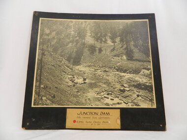
Photo of Junction Dam - Kiewa Hydro Electric Scheme, Junction Dam, Kiewa Hydro Electric Scheme, Photo taken 10th Feb. 1940
The Junction Dam was built by the State Electricity Commission of Victoria as part of the Kiewa Hydro Electric Scheme. This photo show its construction in February 1940. The State Electricity Commission of Victoria were the employers of the Kiewa Hydro Scheme. The work included building dams, power stations and the infrastructure for the work and their employees. Mt Beauty and Bogong village were the places where this scheme was built and where this photo shows part of its construction being Power Station 3. Originally there were 3 Hydro stations built from the 1930's onwards. The scheme finished being built in 1960 and is the biggest Hydro electricity scheme in Victoria.This photo has Historic significance due to Junction Dam built as part of the Kiewa Hydro Electric Scheme by the State Electricity Commission of Victoria. This photo shows its construction in February 1940. This is a black and white photo of Junction Dam viewed from upstream. Junction Dam was part of the Kiewa Hydro Electric Scheme. The picture shows piles of wood and pipes, crane, trucks and a shed on the cleared ground. The photo is mounted on 3 ply wood, painted black.kiewa hydro electric scheme. junction dam. s.e.c.v.. -
 Kew Historical Society Inc
Plan, Melbourne & Metropolitan Board of Works : Borough of Kew : Detail Plan No.1590, 1905
The Melbourne and Metropolitan Board of Works (MMBW) plans were produced from the 1890s to the 1950s. They were crucial to the design and development of Melbourne's sewerage and drainage system. The plans, at a scale of 40 feet to 1 inch (1:480), provide a detailed historical record of Melbourne streetscapes and environmental features. Each plan covers one or two street blocks (roughly six streets), showing details of buildings, including garden layouts and ownership boundaries, and features such as laneways, drains, bridges, parks, municipal boundaries and other prominent landmarks as they existed at the time each plan was produced. (Source: State Library of Victoria)This plan forms part of a large group of MMBW plans and maps that was donated to the Society by the Mr Poulter, City Engineer of the City of Kew in 1989. Within this collection, thirty-five hand-coloured plans, backed with linen, are of statewide significance as they include annotations that provide details of construction materials used in buildings in the first decade of the 20th century as well as additional information about land ownership and usage. The copies in the Public Record Office Victoria and the State Library of Victoria are monochrome versions which do not denote building materials so that the maps in this collection are invaluable and unique tools for researchers and heritage consultants. A number of the plans are not held in the collection of the State Library of Victoria so they have the additional attribute of rarity.Original survey plan, issued by the MMBW to a contractor with responsibility for constructing sewers in the area identified on the plan within the Borough of Kew. The plan was at some stage hand-coloured, possibly by the contractor, but more likely by officers working in the Engineering Department of the Borough and later Town, then City of Kew. The hand-coloured sections of buildings on the plan were used to denote masonry or brick constructions (pink), weatherboard constructions (yellow), and public buildings (grey). Surveyed by the Board of Works in 1903 and published in 1904, Plan No.1590 shows development north of Cotham Road. While this plan includes built structures in Mary Street, Cotham Road, High Street, Park Hill Road, Kent Street, Ridgeway Avenue, and Ermington Lane (now Ermington Place), only part of this section was notated and coloured in this contractor’s copy. Numerous houses, large and small are named on the plan: ‘Cholula’, ‘Belper’, ‘The Uplands’, ‘Spring Grove’ facing Cotham Road; ‘Marion’ facing Kent Street; and ‘Kia Ora’ facing Ridgeway Avenue.melbourne and metropolitan board of works, detail plans, mmbw 1590, survey plans - borough of kew, cartography -
 Kew Historical Society Inc
Plan, Melbourne & Metropolitan Board of Works. Borough of Kew Detail Plan No.1579, 1904
The Melbourne and Metropolitan Board of Works (MMBW) plans were produced from the 1890s to the 1950s. They were crucial to the design and development of Melbourne's sewerage and drainage system. The plans, at a scale of 40 feet to 1 inch (1:480), provide a detailed historical record of Melbourne streetscapes and environmental features. Each plan covers one or two street blocks (roughly six streets), showing details of buildings, including garden layouts and ownership boundaries, and features such as laneways, drains, bridges, parks, municipal boundaries and other prominent landmarks as they existed at the time each plan was produced. (Source: State Library of Victoria). This plan forms part of a large group of MMBW plans and maps that was donated to the Society by the Mr Poulter, City Engineer of the City of Kew in 1989. Within this collection, thirty-five hand-coloured plans, backed with linen, are of statewide significance as they include annotations that provide details of construction materials used in buildings in the first decade of the 20th century as well as additional information about land ownership and usage. The copies in the Public Record Office Victoria and the State Library of Victoria are monochrome versions which do not denote building materials so that the maps in this collection are invaluable and unique tools for researchers and heritage consultants. A number of the plans are not held in the collection of the State Library of Victoria so they have the additional attribute of rarity.Original survey plan, issued by the MMBW to a contractor with responsibility for constructing sewers in the area identified on the plan within the Borough of Kew. The plan was at some stage hand-coloured, possibly by the contractor, but more likely by officers working in the Engineering Department of the Borough and later Town, then City of Kew. The hand-coloured sections of buildings on the plan were used to denote masonry or brick constructions (pink), weatherboard constructions (yellow), and public buildings (grey). While MMBW Plan No.1579 does not include many buildings, those that it does show are significant to Kew’s history. These include the ‘Kew [Railway] Station’ in Denmark Street and the ‘Recreation Hall’ and rear courts off Wellington Street. The plan shows the outline of the Recreation Hall, constructed in 1880, at the rear of which is listed a bowling green, two tennis courts, a ‘skittle alley’ and a pavilion. When the Hall was first built, the Kew Cricket Club occupied an adjacent ground, however in 1885 this was acquired by the State Government as the future location of the Kew Railway Station. The Plan also shows a single oval at Xavier College. This oval was completed in 1883. One of the current ovals conforms to this oval’s original shape and position in the school grounds.melbourne and metropolitan board of works, detail plans, maps - borough of kew, mmbw 1579, cartography -
 Kiewa Valley Historical Society
Photograph Tawonga Hospital, A ward at Tawonga Hospital, 1949/50
This photo is of a ward - probably the female ward, as there a many floral arrangements - of the original hospital at Tawonga. This was situated at the corner of Ryders Lane and Kiewa Valley Highway. The building was transported from Bonegilla where it was originally a part of the Bonegilla Military Hospital. The hospital was opened on 24th September, 1949 with a capacity of 12 beds, but was later increased to 35 beds by enclosing the verandahs on 3 sides of the building. 'Add ons' provided theatre, offices, stores and a nurses home. Construction was commenced by the Hospital and Charities Commission with considerable input from the S.E.C., providing the removal and re-erection of the building, the accommodation for nursing staff and carried all work necessary to make the building operational as a hospital. Up until this time the nearest hospital was at Yackandandah. The hospital remained on this site until 1961 when a larger, more suitable building was purchased in Mt. Beauty from the S.E.C.A photographic record of a typical open plan style ward in that era. There were no private rooms. There are portable screens stored at the end of the room to provide "privacy" at the bedside when needed. There is a fan on the wall for cooling. Depicts the rather primitive conditions of that era when compared with todays standards.Black and white photograph of a ward in the Tawonga District Hospitalhospital, ward, tawonga -
 Bendigo Historical Society Inc.
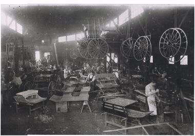
Photograph - COACH BUILDING WORKS
Black and white photograph of a coach building business. Note the number of workers involved in the manufacture of the different styles required by customers. To the right of photo there are a number of workers using machines to manufacture the different body parts that are required. One cart to left of photo appears to be the finished product. Centre top there is a cantilever structure with bodywork stacked on top and a number of wheels, large and small, hanging from the side. There are also a number of wheels hanging from posts of the building framework. Note the differing clothing styles of the workers from shirt, trousers and apron, to hats shirts, waistcoats, trousers. Differing stages of construction have bodies on tables, wooden frameworks, boxes and wooden horses.industries -
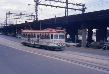
 Melbourne Tram Museum
Photograph - Set of 10 Colour Print/s, Steven Altham, 2001
Set of 10 colour prints of the re construction of the Hawthorn Tram Depot to the Watermark Apartments. .1 - Depot fan Trackwork - 6-2-2001 .2 - ditto looking towards tram depot .3 - view towards the building with the second depot demolished, and forecourt excavations underway - 11-3-2001 .4 - Sign on the building advertising apartments .5 - view from street looking at the old depot wall with drilling rigs. .6 - ditto, looking at the worksite for the new block of apartments and part of the original buildings remaining. .7 - Car park slabs being formed. 11-6-2001 .8 - looking at the south wall of the first depot showing the scale of excavation and underpinning. .9 - looking south west/ .10 - Looking from the street at the car park slab in front of the depot. Colliers Jardine and Bovis Lend Lease signs in the photos.All have details of photograph on rear and photographers name.trams, tramways, watermark apartments, hawthorn depot, construction, tram depot -
 Dutch Australian Heritage Centre Victoria
Etching
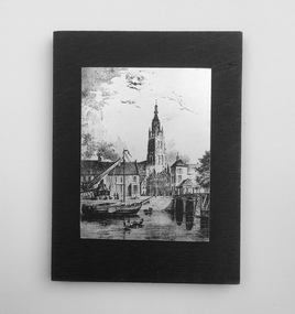
The Vliet is a canal in the western Netherlands, in the province of South Holland. It starts at the Oude Rijn at Leiden and joins the Delfshavense Schie canal at Delft. Places along its banks include Voorschoten, Leidschendam, Voorburg, The Hague and Rijswijk. The canal was dug in 47 AD under command of Roman general Corbulo, who wished to connect the river Rhine, of which the current Oude Rijn stream in Roman times was the main branch, to the Meuse estuary. It is unclear what the canal's trajectory was beyond the current city of Delft; the Delfshavense Schie canal, which connects Delft to the Nieuwe Maas river was not dug until 1389. In the Middle Ages the Vliet was an important trade link that attracted all kinds of trade, as it flowed through the heart of the County of Holland. Windmills have been constructed alongside the Vliet, including the completely renovated mill 'De salamander' in Leidschendam. The Vliet area was particularly attractive among richer families, who built their mansions along its banks.An historic small town scene etched (or possibly printed) on thin metal and subsequently fastened to a plywood backing. The delicately presented scene is said to show the intersection of Old Church Street and the Vliet Canal bridge in Voorburg, as well as a section of wharf. On the canal are one large and two much smaller vessels. A very tall crane-like construction arises from the wharf to the roof of waterside buildings. The people are soberly dressed in possibly 17th or 18th century costumes.On the reverse has been written: "Oude Kerkstraat Brug over de Vliet Voorburg". (Old Church Street; Bridge over the Vliet canal; Voorburg). However, research proves that the church is actually the Old Church in Delft, a short distance further down the Vliet Canal. -
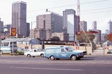 Melbourne Tram Museum
Slide, David Verrier, 22/04/1977 12:00:00 AM
Agfa colour slide, white blue plastic mount. Photograph by David Verrier. View from Spencer St south just before bridge looking back to the city skyline and the Flinders St railway viaduct. An L class is crossing the viaduct. Photo has the City Mutual and SEC Buildings along with some construction work for the new railway viaduct underway. A Shell service station sign is visible. Photos taken 22/4/1977In ink: "Fri 22/4/77 Flinders St Viaduct"trams, tramways, railways, flinders st, melbourne -
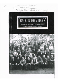 Melbourne Tram Museum
Document - Photocopy, Roger J. Jones, "Back in Them Days' ", c1992/93
Photocopy of cover and five pages extracted from a publication - "Back in Them Days' " - an oral history of Preston edited by Roger J. Jones. Extract features "Tram building" at Preston workshops, features an interview with Clive Boxer. Worked at the workshops 1925 for 6 years, through to 1974, described the construction of trams, working conditions, working hours, the bosses, Industrial relations, wages, repairs, overhauls, working during the depression, and work done during the war.Has in ink on the front cover "Please return to John" item "Tram building" by Clive Boxer, recorded c 1992/93.trams, tramways, preston workshops, oral history, preston, tram bodies -
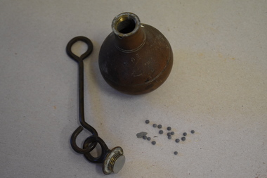 Warrnambool and District Historical Society Inc.
Plumb bob, Early 20th century
A plumb bob or plummet is a weight suspended from a string or rod and used as a vertical reference line or plumb line. It is the vertical equivalent of the water level. It is used to ensure constructions are plumb or level. It has been in use since Egyptian times and is also used in surveying. It is still in use today. This plumb bob weighs 910 grams and was probably used in the building trade. This item is retained as an interesting example of a trade tool from the past.This is a brass weight with a bulbous-shaped body rounded on the bottom, a slender neck and an enclosed top. The top has a metal ring to which is attached a metal rod with a ring at the end. The item is a little stained.building accessories, history of warrnambool -
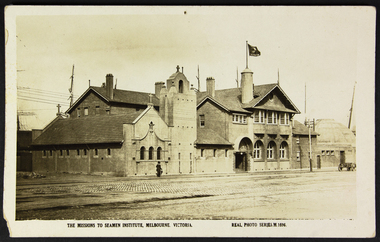 Mission to Seafarers Victoria
Postcard - Postcard, Sepia, Valentines Real Photo Series, The Missions to Seamen Institute, Melbourne Victoria, c. 1922
This postcard depicts the urban setting of the Mission to Seafarers a few years after its construction. (the Dome, the last part erected, was opened on 21 October 1921). It demonstrates a lack of urban surrounds or buildings as well as a paved road and a horse-drawn wagon. The figure in the photo is also a record of the dress style of the era. The lady is most likely a member of the Ladies' Harbour Lights Guild.This postcard demonstrates that the building was deemed important enough to be photographed for a postcard. It is a record of what the Mission to Seafarers looked like two years after its construction, and its urban surrounding.Sepia postcard of the Mission to Seafarers building complex and surrounding streets. The postcard depicts a wagon and a woman walking by the complex wearing a black dress and coat and black hat and holding an umbrella. Front: THE MISSIONS TO SEAMEN INSTITUTE, MELBOURNE VICTORIA REAL PHOTO SERIES.M.1696 Reverse: PUBLISHED BY THE VALENTINE & SONS PUBLISHING CO.LTD / MELBOURNE SYDNEY & BRISBANE. Contains logo of VALENTINES REAL PHOTO SERIES POSTCARD. Stamp logo lists: BRANCHES / SYDNEY / LONDON / DUNDEE / DUBLIN / CAPETOWN / MONTREAL / TORONTO Handwritten in blue: 1919mission to seafarers, melbourne, mission to seamen, seamen's mission, norla dome, flag, flying angel, lady, horse cart, umbrella, flinders street extension, ships, australian wharf, valentine's postcards, real photo series postcards, st peter chapel, lhlg, architecture, walter richmond butler -
 Kew Historical Society Inc
Photograph - Kew Junction, Herald & Weekly Times, 1962
This is an aerial oblique image looking north. It shows Kew Junction before construction of VicRoads (Country Roads Board), Murphy's (Leo's) supermarket, and office towers. It also shows a building on the land now known as the Raoul Wallenberg Reserve, the Kew Municipal Offices in Walpole Street, and St Paul's School for the Blind in Fernhurst Grove, and Kew Bowling Club in Wellington Street.An aerial photograph of Kew Junction, showing the intersection of High Street South, Studley Park Road, Princess Street, High Street and Denmark Street. A number of buildings, now demolished can be identified in the photo, including Jellis’ Bakeries on the corner of Princess Street and Studley Park Road." Annotation on reverse: "Kew Historical Society from Mr L. H. Chinner".kew junction, aerial photograph (kew), oblique aerial, st paul's school for the blind, kew municipal offices, high street kew, studley park road, kew war memorial, kew post office, kew police station, kew court house, high street south, kew, wellington street kew, denmark street kew -
 Hymettus Cottage & Garden Ballarat
Photograph, Church group, 14/06/2020
This group of buildings all of which served as churches at different periods is one of the best visual demonstrations of the rapid growth of Ballarat caused by the boom years of the gold rush following the initial alluvial diggings of the 1850s. The smallest church was built in 1861 followed by the next built in 1867 and finally the construction of the grand church on the corner of Neil and Macarthur streets Soldiers' Hill in the 1890s.methodist church, uniting church, soldiers hill, ballarat. -
 The Beechworth Burke Museum
Photograph, Bayless C. - Manager, 1875
In this photo, taken in around 1875, is depicted the exterior of the Beechworth Mental Asylum buildings, with the administration buildings far right of the photo. A sunken boundary wall in the foreground and some people in view, sitting at the pavillion in the centre of the image. The two-storey buildings, designed in Italianate style, and the three-storey towers at the front, influenced by the asylum at Colney Hatch in England. The architecture of the buildings shares key features with other contemporary institutions, like Aradale at Ararat, and its design is attributed to the Public Works Department architect, J.J. Clark, whose name is connected with the construction of many other important public buildings, such as the Asylums at Kew and Ararat, the front block of the Royal Mint, Melbourne and the Melbourne Customs House. The Mayday Hills Hospital was constructed between 1864 and 1867, with buildings created in a number of periods. It formally opened on 24 October 1867 and, along with the Ovens Hospital and the Benevolent Asylum, made Beechworth a prominent social welfare centre in Victoria. Large masses of granite were excavated for its foundation and around 250 workmen were employed for its construction. The building, divided into six sections, was comprised of dormitories, doctors` rooms and plenty ancillary rooms and facilities, such as laundries, reading rooms, a concert hall and cooking areas. The site was chosen for its panoramic view of the countryside, the hilltop atmosphere and the native fauna, all contributing to the cure of patients. The Hospital was originally named the “Ovens Lunatic Asylum” but during the centenary celebrations in 1967 the name was officially changed to “Mayday Hills Hospital”, showing the gradual shift in the perception and understanding of mental health conditions over the last decades. The Hospital lies on the traditional land of the Kulin Nation.This photograph is historically significant as it provides an insight into the location, surroundings and the exterior of the Mayday Hills Hospital at the end of the 19th century. It also contributes to the understanding of the district`s development and its importance to the course of Victoria`s history and is acknowledged as a unique construction, being one of three identified as the largest of their kind.Black and white rectangular photograph printed on matte photographic paper mounted on board.Reverse: 37/ 3443/ Beechworth Asylum about 1875/ American & Australasian/Photographic Company/Victoria Branch./C.Bayless, Manager./ No./beechworth mental asylum, aradale, public works department, j.j. clark, melbourne customs house, colney hatch, italianate style, mayday hills hospital, royal mint, granite, benevolent asylum, dormitories, ovens lunatic asylum, ancillary rooms, centenary celebrations, three-storey towers, countryside, mental health conditions, kulin nation, concert hall -
 Federation University Historical Collection
Plan - Architectural Plans, Australian Natives' Association Ballarat Branch No 4 Architectural Plans
Percy Richards taught Architecture and Building Construction at The Ballarat Art School - a division of Ballarat School of Mines from 1918-1921. He was responsible for the design of a number of buildings in the district. This item is the "Specification of work required to be done and materiaals required for construction of the new A.N.A. Building at the corner of Sturt, Albert and Lewis Streets, Ballarat. Prepared by and to the satisfaction of P.S. Richards, A.R.V.I.A. Architect and subject to the General Conditions of Contract." "BALLARAT CITY A.N.A. BALLARAT, Wednesday — The Ballarat City branch, A.N.A., which was formed nearly 50 years ago, ranks fourth on the association records, but several of the members were prominent in establishing the association in Melbourne a year or two earlier. On the past half-year's operations the total funds increased by £1558/18/3 to £29.389/11/11. The membership now totals 949. The committee recommended that as the property at the corner of Sturt and Albert Streets, which had been intended as the site of a new hall, had been sold, steps should he taken to remodel the present hall, and bring It up to date. The report was adopted." (The Herald, 18 June 1924)Fourteen detailed drawings showing the specifications for each section of the new A.N.A. building for Ballarat. A 24 page document submitted to the Public Health Department, Victoria, received 15 January 1918 and a 3 page document related to Reinforced Concrete Particulars. All contained in a labelled black metal cylinder.A.N.A.4. PLANS painted on side and lid. Signature of P.S. Richards.ana, australian natives' association, architecture, percy richards, building specifications, ballarat, technical art school ballarat, materials, construction, p.s. richards, percival selwyn richards -
 Bendigo Military Museum
Photograph - Army Survey Regiment - Fortuna & Surrounds, Bendigo, c1985
This set of 30 photographs of the Army Survey Regiment’s Fortuna Villa and surrounding facilities was taken circa 1985. The photos feature much of Fortuna’s exterior and most of the out-buildings spread over the property’s fifteen acres of grounds. After Defence took possession of Fortuna in 1942, the Q-store and engineering workshops were added during the wartime period. Soldiers were accommodated in tents during WW2 for 20 years next to the parade ground before the construction of accommodation buildings in 1962. In 1990 most of the weatherboard buildings in the Q-store area were replaced. A climate-controlled building was also constructed to house a map library and digital data media. This photo set also includes the exterior of Air Survey Squadron’s Building 16 and two modular buildings -16A and 16B that were added in the early 1980s to accommodate map production and technical services. See item 6457.22P for photos of Fortuna Villa’s interior that were taken at the same time.This set of 30 photographs of the Army Survey Regiment’s Fortuna Villa and surrounding facilities was taken circa 1985. The colour photographs were printed on photographic paper and are part of the Army Survey Regiment’s Collection. The photographs were scanned at 300 dpi. .1) - Photo, colour, c1985. Fortuna Villa – view from the lake. .2) to .4) - Photo, colour, c1985. Fortuna Villa – front view. .5) - Photo, colour, c1985. Fortuna Villa – balcony view of transport compound and Air Survey Squadron. .6) - Photo, colour, c1985. Fortuna Villa – balcony view of Q-store and transport compound. .7) - Photo, colour, c1985. Fortuna Villa – balcony view of transport compound and Bendigo. .8) - Photo, colour, c1985. Fortuna Villa – balcony view of Q-store buildings. .9) - Photo, colour, c1985. Fortuna Villa – Pompeii Fountain and Stables. .10) - Photo, colour, c1985. Fortuna Villa – coach house. .11) - Photo, colour, c1985. Lithographic Squadron delivery docks. .12) - Photo, colour, c1985. Fortuna Villa - Original Roman Bath entry. .13) - Photo, colour, c1985. RAEME and carpentry buildings. .14) - Photo, colour, c1985. Q-store buildings. .15) - Photo, colour, c1985. Q-store buildings. .16) - Photo, colour, c1985. Transport compound. .17) - Photo, colour, c1985. Fortuna Villa’s original laundry, gardeners’ building. .18) - Photo, colour, c1985. Duty Room. .19) - Photo, colour, c1985. L to R: Side of Duty Room, RAP building. .20) - Photo, colour, c1985. Transport compound, Q-store in background. .21) - Photo, colour, c1985. Air Survey Squadron’s Building 16 viewed from carpark. .22) - Photo, colour, c1985. Technical Services, Building 16B. .23) - Photo, colour, c1985. Air Survey Squadron’s Building 16 courtyard. .24) - Photo, colour, c1985. Technical Services, Building 16B viewed from Building 16 courtyard. .25) - Photo, colour, c1985. Air Survey Squadron’s Building 16A and fernery viewed from walkway. .26) - Photo, colour, c1985. Officers Accommodation. .27) - Photo, colour, c1985. Other Ranks (OR’s) ‘New’ Barracks. .28) - Photo, colour, c1985. OR’s Kitchen and Dining Room. .29) & .30) - Photo, colour, c1985. Army Survey Regiment - Front Entry GateThere are brief descriptions on a note behind each photograph.royal australian survey corps, rasvy, army survey regiment, army svy regt, fortuna, asr -
 Ballarat Tramway Museum
Photograph - Black & White Photograph/s, Lloyd Rogers, 13/12/1961 12:00:00 AM
Yields information about the appearance of trams parked in the City loop during early 1960's and the construction of the Big W store.Black and white photograph of Ballarat trams 21, 33 and 26 in the City Loop. Dated 13/12/1961. Printed on Agfa Gevaert paper in a postcard format. 21 - has a roof advertisement fort A. H. Collins of Sebastopol for Timber and The Age and another on the dash panel. 32 - has roof adverts for Penfold Cream Sherry cream and Eureka Terra Cotta tiles. In the background, a building (possibly the future Big W) is under construction in Grenville St. Photo by Lloyd Rogers.In ink "Ballarat trams Nos. 21, 33, 26, Sturt St 13/12/1961 and 3/19". In pencil: "21 - ex 10 Alaide, 33- ex M 189, 26 - ex M 111"trams, tramways, city loop, sturt st, tram 21, tram 33, tram 26 -
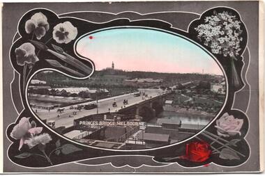 Melbourne Tram Museum
Postcard, SEMCO, "Princes Bridge Melbourne", mid 1900's?
Divided back postcard featuring a hand coloured black and white photograph of a view looking from Flinders St towards Government House, c1900, or from the roof of the Flinders St Station which could be under construction. Embossed Photograph enclosed within an artists palette, surrounded by roses. Note the buildings between the bridge and Government house - a former asylum? Card from the SEMCO Series Box 545 GPO Melbourne. Addressed to Miss V Hall of Blackwood.trams, tramways, princes bridge, cable trams, flinders st, flinders st station -
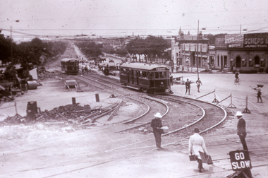 Melbourne Tram Museum
Slide, Melbourne & Metropolitan Tramways Board (MMTB), c1926
35mm colour slide TMSV copy slide of trackwork at St Kilda Junction, possibly soon after a change over to the new track in St Kilda Road. Has W 366 (St Kilda Beach) on the temporary or new track pending the construction of a road surface and the link to Wellington St. Photo may be from a photo held in the Public Records Office series. On the corner of Punt and St Kilda Road is s building advertising Schweppes Junction Motor service station."MP 30" in pencil on the side.trams, tramways, st kilda junction, trackwork, new tramways, w class, road works, tram 366 -
 Melbourne Tram Museum
Slide - Set of 2, Warren Doubleday, Dec. 1970
Set of 2 Colour slides- Anscochrome plastic mount taken during 12/70 of W7 1024 (Spencer St Route 74) in Flinders St dressed as the MMTB Christmas Tram .1 - running alongside the Flinders St viaduct. .2 - in Spencer St between Little Collins St and Collins St (Burwood Route 74) with the MMBW building under construction and 616 Little Collins St (MMTB Head Office) in the background. In the view is a shop selling Cadbury's Chocolate.Has slide number written on itemtrams, tramways, w7 class, mmtb, mmbw, route 74, spencer st, flinders st, tram 1024 -
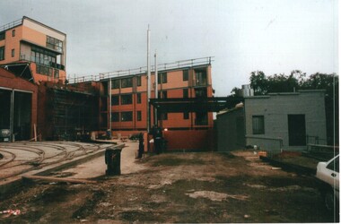 Melbourne Tram Museum
Photograph - Set of 9 Colour Print/s, Steven Altham, 27/02/2002 12:00:00 AM
Set of 9 colour prints of the re construction of the Hawthorn Tram Depot to the Watermark Apartments. All taken on 27-2-2002 .1 - View from Wallen Road with the track work relaid, new end wall on the original building and the facade for the 2nd depot being constructed. .2 - new facade to the original section of the depot with tracks. .3 - part of the new apartments .4 - From Power St looking between the original and new buildings. .5 - ditto .6 - ditto .7 - looking from Power St at the south end of the new block. .8 - view of trackwork and fan concreted in. .9 - ditto Colliers Jardine and Bovis Lend Lease signs in the photos.All have details of photograph on rear and photographers name.trams, tramways, watermark apartments, hawthorn depot, construction, tram depot -
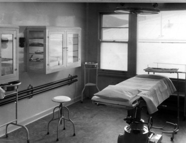 Kiewa Valley Historical Society
Photograph Tawonga District Hospital, Theatre at Tawonga District Hospital, 1949/50
The original Tawonga District Hospital was situated at the corner of Ryder's Lane and Kiewa Valley Highway. The construction was initiated by the Hospital and Charities Commission with considerable assistance from the State Electricity Commission.The building was transported from Bonegilla where it was originally a part of the Bonegilla Military Hospital. It started with 12 beds and eventually increased to a total of 35 beds. "Add ons" provided theatre, offices, stores and Nurses Home. It was officially opened on 24th September, 1949. Up until this time, any person requiring hospitalisation had to travel to Yackandandah. This photograph is of the theatre and there was no anaesthetic or recovery rooms. While rather primitive by todays standard, it met the demands of the construction days as well as that of the Kiewa Valley community. Shows the rather spartan conditions and equipment of the theatre in the original Tawonga District Hospital compared to the present day hospital. Black and white photograph of the operating theatre in the original Tawonga District Hospitalhospital, operating theatre, tawonga -
 Kew Historical Society Inc
Plan, Melbourne & Metropolitan Board of Works : Borough of Kew : Detail Plan No.1350, 1910
The Melbourne and Metropolitan Board of Works (MMBW) plans were produced from the 1890s to the 1950s. They were crucial to the design and development of Melbourne's sewerage and drainage system. The plans, at a scale of 40 feet to 1 inch (1:480), provide a detailed historical record of Melbourne streetscapes and environmental features. Each plan covers one or two street blocks (roughly six streets), showing details of buildings, including garden layouts and ownership boundaries, and features such as laneways, drains, bridges, parks, municipal boundaries and other prominent landmarks as they existed at the time each plan was produced. (Source: State Library of Victoria). This plan forms part of a large group of MMBW plans and maps that was donated to the Society by the Mr Poulter, City Engineer of the City of Kew in 1989. Within this collection, thirty-five hand-coloured plans, backed with linen, are of statewide significance as they include annotations that provide details of construction materials used in buildings in the first decade of the 20th century as well as additional information about land ownership and usage. The copies in the Public Record Office Victoria and the State Library of Victoria are monochrome versions which do not denote building materials so that the maps in this collection are invaluable and unique tools for researchers and heritage consultants. A number of the plans are not held in the collection of the State Library of Victoria so they have the additional attribute of rarity.Original survey plan, issued by the MMBW to a contractor with responsibility for constructing sewers in the area identified on the plan within the Borough of Kew. The plan was at some stage hand-coloured, possibly by the contractor, but more likely by officers working in the Engineering Department of the Borough and later Town, then City of Kew. The hand-coloured sections of buildings on the plan were used to denote masonry or brick constructions (pink), weatherboard constructions (yellow), and public buildings (grey). MMBW Plan No. 1350 depicts the western end of Studley Park on the north side of the Studley Park Road. ‘Raheen’, then the home of Sir Henry Wrixon is named, the plan identifying those parts of the house that were built of brick and timber. The two houses between Raheen and the River Yarra are also shown. Other parts of the plan show neighbouring streets: Yarra Street, Studley Park Avenue, Studley Street and Fenwick Street. Each, apart from Fenwick Street was subsequently renamed. At the corner of Fenwick and Stawell Streets, the home of Joseph Butterworth Coombs, later called ‘Hope Mansell’, is represented but unnamed.melbourne and metropolitan board of works, detail plans, mmbw 1350, cartography -
 Kew Historical Society Inc
Plan, Melbourne & Metropolitan Board of Works : Borough of Kew : Detail Plan No.1565, 1905
The Melbourne and Metropolitan Board of Works (MMBW) plans were produced from the 1890s to the 1950s. They were crucial to the design and development of Melbourne's sewerage and drainage system. The plans, at a scale of 40 feet to 1 inch (1:480), provide a detailed historical record of Melbourne streetscapes and environmental features. Each plan covers one or two street blocks (roughly six streets), showing details of buildings, including garden layouts and ownership boundaries, and features such as laneways, drains, bridges, parks, municipal boundaries and other prominent landmarks as they existed at the time each plan was produced. (Source: State Library of Victoria). This plan forms part of a large group of MMBW plans and maps that was donated to the Society by the Mr Poulter, City Engineer of the City of Kew in 1989. Within this collection, thirty-five hand-coloured plans, backed with linen, are of statewide significance as they include annotations that provide details of construction materials used in buildings in the first decade of the 20th century as well as additional information about land ownership and usage. The copies in the Public Record Office Victoria and the State Library of Victoria are monochrome versions which do not denote building materials so that the maps in this collection are invaluable and unique tools for researchers and heritage consultants. A number of the plans are not held in the collection of the State Library of Victoria so they have the additional attribute of rarity.Original survey plan, issued by the MMBW to a contractor with responsibility for constructing sewers in the area identified on the plan within the Borough of Kew. The plan was at some stage hand-coloured, possibly by the contractor, but more likely by officers working in the Engineering Department of the Borough and later Town, then City of Kew. The hand-coloured sections of buildings on the plan were used to denote masonry or brick constructions (pink), weatherboard constructions (yellow), and public buildings (grey). MMBW Plan No.1565 is an example of a plan where a number of streets have been created since the area was surveyed, or in other cases renamed. The plan shows those streets that were bordered by Ross Street, Mount Street, Sackville Street and Burke Road. Since 1905, Mawson Street has been created and Mont Albert Road renamed as Dean Street. Named houses on the plan include ‘Tyrol’, ‘Glengorse’, ‘Theodore Villa’, ‘Arncliffe’, ‘Ballynira’ and ‘Hazeldene’. The plan also shows a Wesleyan Church in Sackville Street. In 1883, the Church’s Sunday School celebrated its silver anniversary.melbourne and metropolitan board of works, detail plans, mmbw 1565, cartography -
 Melbourne Tram Museum
Photograph - Black and white - Glenferrie Road, Glenferrie c1915
Shows Glenferrie Road, near Linda St looking south, c1915 prior to the construction of the Railway overpass at Glenferrie Railway Station with H class tram 58 in the view. The tram line was constructed in 1913. It would appear that the level crossing gates are closed in the photograph. The building on the right-hand side by the horse-drawn cart was an ANZ bank until 2021. The closer building, a theatre (The Palace) has since been demolished and is now a Coles Supermarket. The level crossing was replaced with an overbridge in April 1916. The church in the background is the Immaculate Conception Church, without the spires - built after WW1. Yields information about the location, the streetscape and the tram, vehicles in use at the time. Black and white photograph of Glenferrie Road Glenferrie with tram H58, looking south near Linda St, c1915."RSCP 327" & "C1920s" in pencil on rear and H58 in red ink.tramways, trams, glenferrie road, hawthorn, streetscapes, h class, tram 58 -
 Eltham District Historical Society Inc
Audio Compact Cassette Tape, Audio Recording; 2003-09-10 Speaker Panel: Builders of the Eltham Tradition, 2003
September Meeting (Newsletter No. 152, Sep. 2003) This meeting is one in an occasional series where we get together a panel of speakers to talk about a particular aspect of Eltham's history, its character or its people. As has been the case for past speaker panels, we have organised a buff et dinner to precede the meeting and details of this are given below. Eltham has a well-known tradition of building with mud brick, second hand materials and other innovative or uncommon materials. Although this trend dates mainly from the 1930 's there are examples from the pioneer days of Eltham. Part of the Brocksopp house at Eltham South is an 1850' s mud brick construction by George Souter. But the alternative building tradition in Eltham really began at Montsalvat in the 1930's. Justus Jorgensen's building complex of earth construction, stone and items from wreckers' yards inspired a number of builders and owner builders, particularly in adopting mud brick or adobe as their building medium. The tradition continues today with our area remaining home to a relatively high proportion of builders using these alternative materials. The panel we have selected to talk on this subject are either builders in the Eltham tradition or have had close contact with builders of the past. The panel will be introduced by Russell Yeoman who will talk briefly about George Stebbing, an early Eltham builder responsible for many of our remaining historic buildings, but known for traditional buildings of his time rather than the later buildings which give Eltham its particular character. The panel members are as follows:- • John Pizzey, architect. John will speak on the work of Alistair Knox designer and builder in mud brick and the person who has most contributed to the environmental building traditions of Eltham. • Peter Jarvis who will talk about his own work as a builder in mud brick and his views on traditional and modern construction methods. • Leigh Wykes, a present day builder of stone houses, will talk about his own work in the district and its relevance to Eltham traditions. • Diana Bassett-Smith will talk about her experience with owner-builders constructing their earth houses in Eltham in the 1950's. Pise and mud brick presented a cheap building material provided that you could do it yourself or persuade your friends to help. Prior to the meeting there will be a buffet dinner of casseroles and other courses prepared by some of our members. We will be starting at 6.00pm with dinner scheduled for 6.30. Harry Gilham will be providing drinks, including wines from his personally made collection. Cost of the dinner will be $10 which can be paid on the night. However, for catering purposes we need to know numbersCompact audio cassette Sony EF 90 Type I / IEC I Cassette labelled "Eltham Builders Historical" Converted to MP3 file; 100MB, 1:18:57 alistair knox, audio cassette, audio recording, building construction, diana bassett-smith, eltham, john pizzey, leigh wykes, peter jarvis, society meeting