Showing 679 items
matching cotham road - kew
-
 Melbourne Tram Museum
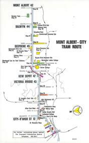
Map, Melbourne & Metropolitan Tramways Board (MMTB), Set of 15 tram route maps, 1977 to 1979
... Kew- Cotham Road... Beach Route 1 Route 2 Route 15 Route 16 Route 55 Kew- Cotham ...Series of 15 colour route maps for various tram lines or groups of tram lines for the MMTB. Some have the Transport Information Centre telephone printed on them, others have a label stuck on. Some are finished with a plastic laminate finish on either one or both sides. Show the major cross streets, parks, schools, other tram routes, major stop numbers and railway lines. Two copies of each held unless noted otherwise. .1 - Mont - Albert City - R11/77, shows routes 43. 47. 45. 44 .2 - Malvern, East Malvern, Carnegie and East Brighton Tram Routes (from St Kilda Junction) - R1/79 - shows routes 5, 3, 67, 66, 61, 62 and 64. .3 - Swanston St tram guide - R1/79 - lists all routes and route numbers that branch or cross Swanston St between Grattan St and St Kilda Junction. .4 - St Kilda Rd Tram Routes R12/77 - details South Melbourne Beach, route 1 and route 2 and St Kilda Beach routes 15, 16 and 55 otherwise shows were the various routes branch off St Kilda Road. Copy 1 has "P14909" in pencil in the bottom right hand corner. .5 - Kew - St Kilda Beach - R1/79 - Route 69. .6 - Footscray - Moonee Ponds - R3/81 - Route 82 .7 - Flinders St tram routes - R5/78 - North Balwyn, East Burwood, routes 48, 40, 41, Hartwell, 28, 74 and 75 .8 - William St tram routes - Route 55, 56 and 63 - South Melbourne Depot and Domain. copy 2 has "P14913" in bottom right hand corner. .9 - Toorak Camberwell and Glen Iris tram routes with Camberwell Junction and Malvern Town Hall, R1/79, routes 8, 7, 6, 72 and 73 shown. .10 - Swanston St tram routes - R12/77 - shows all the Swanston St routes, including East Coburg and Moreland. .11 - Bourke St tram routes - R4/77 - East Brunswick Blyth St and East Preston Tyler St and intermediate routes, routes 95, 96, 97, 90, 89 and 88. .12 - as for .11, dated 1/85, showing extension to La Trobe University - has Metropolitan Transit logo. Only 1 copy held. Also shows route 92 and 87. .13 - Batman Ave tram routes - R9/77 - Wattle Park, North Richmond and Prahran - routes 70, 71, 78 and 79. .14 - City route guide - R9/77 - showing all route numbers and destinations that passed through the CBD. .15 - Elizabeth St tram routes - R12/77 - Essendon Airport, West Maribyrnong, North Coburg lines, routes 50, 58, 60, 54, 57, 52. 49, 59, 18, 20 and 19. Copy 1 has "P14905" in pencil in bottom left hand corner.trams, tramways, maps, route guide, route numbers, routes, mont albert, route 43, route 47, route 45, route 44, route 42, malvern burke rd, east preston, carnegie, east brighton, south caulfield, route 5, route 3, route 67, route 62, route 64, route 66, glenhuntly tram depot, swanston st, st kilda rd, south melbourne beach, st kilda beach, route 1, route 2, route 15, route 16, route 55, kew- cotham road, route 69, route 79, route 82, footscray, moonee ponds, flinders st, north balwyn, kew, east burwood, burwood, hartwell, richmond, route 48, route 40, route 41, route 28, route 74, route 75, route 56, route 63, william st, west coburg, toorak, camberwell, glen iris, malvern town hall, route 72, route 73, route 7, route 8, bourke st, route 6, route 95, route 96, route 97, route 90, route 89, route 89, east preston, east brunswick, la trobe university, clifton hill, route 92, route 87, route 70, route 71, route 78, route 79, north richmond, prahran, wattle park, essendon airport, west maribyrnong, north coburg, route 50, route 58, route 60, route 54, route 57, route 52, route 49, route 59, route 18, route 20, route 19, batman ave -
 Melbourne Tram Museum
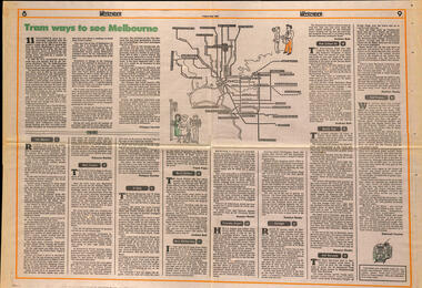
Newspaper, The Age, "Tram ways to see Melbourne", 8/5/1981
Newspaper clipping, from The Age, Weekender, Friday 8/5/1981 titled "Tram ways to see Melbourne", with a number of writers giving a short piece on a particular line. Has a Map of the Melbourne system with destination and route numbers. Has an introduction written by Phillipa Hawker which looks at the history, its place in Melbourne, and possibilities for the future. Written just before the MTA came into existence. Items: East Malvern, Route 3, Rebecca Batties West Preston Route 10, Phillipa Hawker St Kilda, Route 12, Frank Prain North Balwyn, route 48, Andrew Bolt West Maribyrnong route 57, Rosslyn Beeby Essendon Airport, Route 59, Rosslyn Beeby Carnegie, Route 67, Andrew Bolt Kew Cotham Rd, route 69, Andrew Bolt Wattle Park, route 70, Rosslyn Beeby East Burwood, route 75, Rosslyn Beeby East Preston, route 88, Deborah Forster Has some sketches of trams and people.trams, tramways, melbourne, people and places, tourism, east malvern, west preston, st kilda, north balwyn, west maribyrnong, essendon airport, carnegie, kew- cotham rd, wattle park, east burwood, east preston, route 3, route 10, route 12, route 48, route 57, route 59, route 67, route 69, route 70, route 75, route 88, maps -
 Melbourne Tram Museum
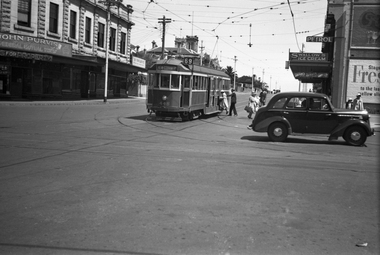
Negative, Wal Jack, 4/01/1943 12:00:00 AM
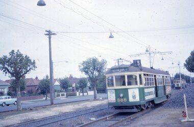
Black and white negative, by Wal Jack, of maximum traction tram N 118 (Kew Cotham Rd Route 69) and possibly CW5 682 passing. The driver of 118 has his handles and point bar in hand while attending to the pole. N 118 is on turning loop track at the intersection of Carlisle St and The Esplanade. Photo dated 4-1-43 in the Wal Jack album along with details of the location and the tramcar.trams, tramways, st kilda, the esplanade, route 69, carlisle st, n class, tram 118, cw5 class, tram 682, world war ii -
 Melbourne Tram Museum
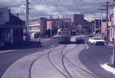
Negative, Wal Jack, 19/01/1941 12:00:00 AM
... Trams tramways Glenferrie Road Riversdale Road W2 class Kew ...Black and white negative by Wal Jack of W2 448 at the intersection of Glenferrie Road and Riversdale Road tram stop, with passengers boarding or having left the tram. Note the tram stop sign on the shop verandah. In the background is the building advertising John Purvis, Property sales and Federal Mutual life insurance. ON the opposite side is a Milk bar, advertising Swallow's Ice creamtrams, tramways, glenferrie road, riversdale road, w2 class, kew- cotham rd, route 69, passengers, tram 448 -
 Melbourne Tram Museum
Album - Robert Thomson Slide Collection, AETA Convention 1978 Melbourne
Photo - see pdf file for further information. Number Brief Description RT175 St Kilda Carlisle St - tram 966 - "Kew Cotham Rd" - route 69 RT176 Pantograph W Class RT177 Z Class 91 Preston 28-3-78 - tram 91 - " Northcote Dundas St via High St" RT178 Z Class cars Preston 28-3-78 RT179 Wheel Transport Car 16W "Q" Class Preston 28-3-78 RT180 Z Class 51 Royal Park Res Track 27-3-78 - tram 51 -"Special" RT181 W6 - 990 - Glen Iris Terminus 26-3-78 "City" - route 6 RT182 w7-1007 Elizabeth Street Terminus 24-3-73 "Essendon Airport" - route 59 RT183 Z Class 51 Napier St Siding Essendon 27-3-78 - "City" RT184 Volvo Bus Swanston - Flinders 24-3-78 - "Bulleen via North Kew" - route 202 RT185 W6 - 878 Burwood Old Terminus 26-3-78 - "Spencer St" - route 74 RT186 W6 - 878 Burwood Old Terminus 26-3-78 - "Spencer St" - route 75 RT187 East Burwood Andrews Street 26-3-78 RT188 East Burwood Elgar Road 26-3-78 RT189 East Burwood Reservation Parer Street 26-3-78 RT190 East Burwood Terminus 26-3-78 RT191 East Burwood Terminus 26-3-78 RT192 "6" RT193 "5" RT194 "4" RT195 "3" RT196 "2" RT197 "1" Z Cars under constructionDemonstrates the work of Robert Thomson in photography, collection and/or production of slidesAssembled album in a black presentation folder of 23 colour slides, collected or produced by Robert Thomson. All photographs have been scanned and placed on the Museum's G drive. A list of all photographs with details has been compiled. melbourne, tramways, trams -
 Melbourne Tram Museum
Album - Robert Thomson Slide Collection, "Melbourne AETA 1964"
Photo - see pdf file for further information. Number Brief Description RT198 SW6 888 Dandenong Rd 1-4-64 - "Malvern Rd Burke Rd" - route 5 RT199 W2 552 Dandenong Rd 1-4-64 - "City" - route 5 RT200 W3 655 Dandenong Rd 1-4-64 - "City" - route 64 RT201 SW6 951 St Kilda Beach 1-4-64 - "Kew Cotham Rd" - route 69 RT202 10 W3 667 East Coburg 1-4-64 - "South Melb Beach" - route 1 RT203 W5 826 top of Latrobe St (?) 1-4-64 - "City via La Trobe St" - RT204 L 105 Carnegie 1-4-64 -"city" - route 4 RT205 L 101 Carnegie 1-4-64 - "University" - route 4 RT206 tram 612 - "Burwood" - Batman Ave (?) RT207 Y1 611 Batman Ave 4-4-64 - "Wattle Park Elgar Rd" RT208 Hawthorn Depot 25-3-64 - trams 582 & 841 RT209 L 105 City Swanston St 25-3-64 route 4B RT210 SW6 853 Chapel St Richmond 25-3-64 -"Prahran" - route 77 RT211 L 102 City Swanston St 25-3-64 - "Carnegie" - route 4 RT212 27-4-62 - tram 495 - "Camberwell" - route 7 & tram 334 RT213 tram 11 - "Special" Flinders St RT214 March 1964 - tram 779 - "West Coburg via William St" - route 55 RT215 March 1964 W7 Collins St - tram 1024 - "Northcote via St Georges Rd" - route 9A RT216 March 1964 Victoria Parade - tram 892 - "City" - route 42 RT217 March 1964 Spring St - tram 1034 - "East Preston" - route 88 RT218 March 1964 Essendon Terminus - tram 741 - "City" - route 59 RT219 1964 AETA Convention - tram 672 - "City" RT220 1964 AETA Convention - tram 672 - "West Coburg Bell St" RT221 1964 AETA Convention - tram 676 - "Leura Grove" RT222 1964 AETA Convention - tram 672 - "Special" tram bridge RT223 1964 AETA Convention - tram 672 - "Special" RT224 1964 AETA Convention - tram 676 - "Burwood" RT225 1964 AETA Convention - tram 672 - "City" - route 59 RT226 1964 AETA Convention - tram 672 - "Special" RT227 1964 AETA Convention - tram 469 - "Special" & tram 895 - "City" - route 2A RT228 1964 AETA Convention - tram south melb depot works yard Demonstrates the work of Robert Thomson in photography, collection and/or production of slidesAssembled album in a black presentation folder of 31 colour slides, collected or produced by Robert Thomson. All photographs have been scanned and placed on the Museum's G drive. A list of all photographs with details has been compiled. melbourne, tramways, trams, mmtb, hawthorn depot, sw6 class, w2 class, w3 class, w4 class, w5 class, w7 class, y class, y1 class, x2 class, sw5 class, l class, south melbourne per-way yard, tram 11, tram 3, tram 9, tram 485, tram 676, tram 672, tram 1024, tram 1034, tram 841, tram 469, tram 611, tram 612, tram 101, tram 102, tram 105, tram 826, tram 779, tram 741, tram 655, tram 467, tram 552, tram 582, tram 495, tram 334, tram 888, tram 951, tram 853, tram 892, tram 895, route 59, route 2a, route 88, route 42, route 9a, route 55, route 7, route 4, route 77, route 4b, route 1, route 69, route 64, route 5 -
 Melbourne Tram Museum
Album - Robert Thomson Slide Collection, "Melbourne 14/9/91 to 21/9/91 16.11.1997 to 23.11.1997"
Photo - see pdf file for further information. Number Brief Description RT229 1997, Carlisle St, tram 129 - "Kew - Cotham Rd" - route 69 & tram 905 - "St Kilda Beach" - route 16 RT230 1997, Dandenong Rd, tram 86 - "Melbourne" - route 69 RT231 1997, Victoria Pde, tram 856 - "City Circle" - route 00 RT232 1997, Spring St, tram 909 - "City Circle" - route 00 RT233 1997, Swanston St, tram 982 - "University" - route 72 RT234 1997, Swanston St, tram 949 - "Glen Iris" - route 6 & tram 852 - "St Kilda Beach" - route 16 RT235 1997, Swanston St, tram 845 - "University" - route 16 RT236 1997, Swanston St, tram 951 - "?" - route 8 RT237 1997, Flinders St, tram 925 - "City Circle" - route 00 7 tram 2034 - "City La Trobe St" RT238 1997, Tram Defect, tram 98 RT239 1997, Flinders St Station, tram 785 - "?" - route 8 RT240 1997, Flinders St Station, tram 211 - "Moreland" - route ? RT241 Bourke St, tram 2059 - "City Spencer St"- route 87 RT242 St Georges Rd Preston, tram 1003 - "Preston" via St Georges Rd"- route 9 RT243 West Preston Terminus - tram 943 - "St Kilda Beach" - route 10 RT244 Princes Bridge , tram 950 - "City" - route 72 RT245 1997 Port Melb Ter, tram 265 - "Mont Albert" - route 109 RT246 1997 Port Melb Terminus RT247 1997 Port Melb Terminus, tram 285 - "Mont Albert" - route 109 RT248 North Balwyn Terminus, tram 244 - "City Lonsdale St" - route 48 RT249 1997 Bourke St mall, tram 2127 - "Bundoora RMIT" - route 86 RT250 1997 Bourke St mall, tram 2028 - "St Kilda Beach" - route 96 RT251 1997 Batman Ave, tram 239 - "Princes Bridge" - route 70 RT252 1997 Batman Ave Ter, tram 233 - "Wattle Park" - route 70 RT253 Princes Bridge , tram 960 - "City" - route 64 RT254 Swanston St at Flinders St, tram 776 - "Glen Iris" - route 6 & tram 809 - "Toorak" - route 8 RT255 Swanston St at Bourke St, tram 978 - "City" - route 64 RT256 Bourke St at Swanston St, tram 112 - "City" - route 86 RT257 South Melbourne Beach terminus, tram 818, - "East Coburg" - route 1 RT258 Carlisle St, tram 925 - "Kew Cotham Rd" - route 69 RT259 Acland St Terminus, tram 2018 - "East Brunswick" - route 98 RT260 St Kilda Rd Princes Bridge, "St Kilda Beach" - route 15 RT261 Batman Avenue Terminus, tram 24 "Special" & tram 22 - "Wattle park Elgar Rd" - route 70 RT262 Acland St Terminus, tram 646 - "City" - route 16 RT263 Bundoora Terminus - tram 2023 - "Bundoora" - route 86 Demonstrates the work of Robert Thomson in photography, collection and/or production of slidesAssembled album in a black presentation folder of 35 colour slides, collected or produced by Robert Thomson. All photographs have been scanned and placed on the Museum's G drive. A list of all photographs with details has been compiled. melbourne, tramways, trams -
 Melbourne Tram Museum
Album - Robert Thomson Slide Collection, "Melbourne 1970 - 1979"
Photo - see pdf file for further information. Number Brief Description RT264 Elizabeth St, at Bourke St, with the construction of the State Savings Bank building (State Bank Galleria) underway. Bourke St Mall also under construction, Note tram warning Sign, tram 1065 - "West Maribyrnong" - route 57 RT265 St Kilda Road, tram 778 - "City" -route 59 RT266 St Kilda Road, tram 569 - "East Malvern Darling Road" -route 3 & tram 819 - "Glen Iris" - route 6 RT267 Swanston St, tram 538 - "City" - route 2A RT268 St Kilda Junction, tram 924 - "City" - route 5 RT269 St Kilda jct, tram 280 - "St Kilda Beach" - route 15 RT270 St Kilda Road, tram 507 - "City" - route 72 RT271 Nicholson St Gertrude St - tram7 - "East Preston Tyler St" - route 88 RT272 West Coburg, tram 778 - "Domain Rd" - route 55 RT273 Wests Road, tram 750 - "Moonee Ponds" - route 22 RT274 St Kilda Rd, tram 8 - "Special" RT275 Nicholson St Victoria Pde, tram 10W - "Special" RT276 L Class Queens way, "City" - route 54 RT277 Bourke St at Spring St, tram 998 - "East Coburg" - route 88 RT278 Nicholson St MMTB Bus, bus 562 - "Garden City via Port Melb" - route 2 RT279 Church St Burwood Rd Jct, tram 9 - "Special" RT280 Riversdale Rd at Camberwell Depot - "Burwood" - route 74 RT281 Balaclava Junction - tram 819 - "Kew Cotham Rd" - route 69 RT282 East Brunswick Terminus, tram 4 - "City Spencer St" - route 96 RT283 Peel St - tram 927 - "Special" RT284 East Brighton Terminus - tram 563 & tram 926 - "City" - route 64 RT285 Dandenong Rd Hawthorn Rd, tram 346 - route 64 RT286 Bourke St at Spring St, tram 34 - "North Fitzroy Park St" - route 97 RT287 Route 69 Terminus St Kilda - tram 369 - "Kew Cotham rd" - route 69 RT288 Route 78 Terminus St Kilda, tram 498 - "North Richmond" - route 78 RT289 Track relay, Fitzroy St, St Kilda RT290 Fitzroy St, St Kilda Demonstrates the work of Robert Thomson in photography, collection and/or production of slidesAssembled album in a black presentation folder of 27 colour slides, collected or produced by Robert Thomson. All photographs have been scanned and placed on the Museum's G drive. A list of all photographs with details has been compiled. melbourne, tramways, trams, track construction, elizabeth st -
 Melbourne Tram Museum
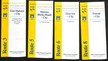
Ephemera - Timetable - The Met - set of 16, The Met, 1993
SSet of 16 The Met timetables, diagrammatic map, major stops and contact details. All dated May 1993 unless noted otherwise. 1 - Route 3 - East Malvern - City with a note that route 377 bus service replaces trams on Sunday. 2 - Route 5 - Malvern (Burke Rd) - City 3 - Route 6 - Glen Iris - City 4 - Route 8 - Toorak - City 5 - Route 10 - Sth Melbourne Beach and St Kilda Beach - West Preston 6 - Route 19 - North Coburg - City with a note that route 319 bus service to Gowrie and Upfield was included - ran Saturday afternoons and Sundays only. 7 - Route 42 - Mont Albert - City 8 - Route 48 - North Balwyn - City 9 - Route 55 - West Coburg - Domain Road interchange - with a note that route 68 operates via Elizabeth St on Sunday. 10 - Route 57- West Maribyrnong - City - with a note that route 357 bus services replaces trams on Sunday 11 - Route 59 - Airport West - City 12 - Route 64 - East Brighton - City 13 - Route 69 - Kew (Cotham Rd) - St Kilda Beach via Glenferrie Road 14 - Route 70 - Wattle Park - Princes Bridge 15 - Route 72 - Camberwell - City 16 - Route 82 - Moonee Ponds - Footscray and that route 223 bus replaces trams on Saturday afternoons and all day Sunday,Yields information about some of The Met tram services May 1993Set of 16 The Met timetables, DL size, printed in two colours.timetables, the met, route 8, route 3, route 5, route 6, route 10, route 19, route 42, route 48, route 55, route 57, route 59, route 64, route 69, route 70, route 72, route 82 -
 Melbourne Tram Museum
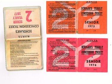
Ephemera - Ticket/s, Melbourne & Metropolitan Tramways Board (MMTB), "Scholar's Yearly Concession Ticket", 1975 to 1977
Set of two clothed backed paper tickets, printed as a MMTB "Scholar's Yearly Concession Ticket", for Seniors and one paper ticket contained within a plastic envelope. Gives condition of use on the outside cover. Each issue to Roderick Atkins. Each lists the various terms for which they were available and available from Cotham and Glenferrie Road, to Callantinia Road, Scotch College. Two sections. .1 - Orange cloth, Senior 1975, cost not shown No. 18 .2 - red cloth, Senior 1976, cost $39.00 No. 203 issued at Doncaster Depot .3 - light yellow paper within a plastic envelope, Senior 1976, cost $39, No. 42583, issued at Kew Depot. See Reg Item 5571 for other examples of item 3trams, tramways, mmtb, tickets, schools, schools tickets, scholar's tickets -
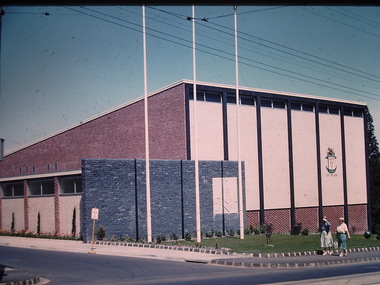
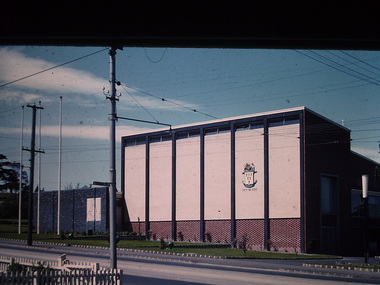
 Kew Historical Society Inc
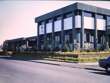
Photograph - Kew Civic Offices, Ron Setford, 1973
Ron Setford and his wife Grace Setford lived in Tanner Avenue, East Kew, from c.1946 to c.1995. A keen photographer, he recorded the changing face of Kew over a 20 year period. Apart from 30 photographs of built structures and places in Kew dating from 1960 and 1961, 145 of his 35mm colour slides chronicle the development of the Eastern Freeway through the Yarra Valley over a five year period from c.1972 to c.1977. This important collection was donated to the Society by his granddaughter in 2025.This collection of 175 35mm slides is of local and statewide significance, owing to its subject matter, particularly the major development of road transport infrastructure during the 1970s with the construction of the Eastern Freeway. The photographer also took care to annotate and date most of his slides which enable the researcher to pinpoint temporal and spatial locations."Kew - "Taj-Mahal" / Cotham Rd - Charles St / Oct 73"ron setford, kew civic offices -
 Kew Historical Society Inc
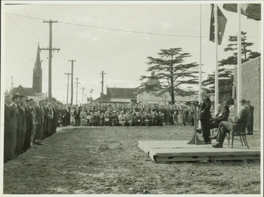
Photograph - Anzac Day Service in front of the Kew City Hall and World War II Memorial, 1960
The Kew City Hall, designed by the architect Harold Bartlett of Leith & Bartlett, was opened by The Premier The Hon HE Bolte on 23rd April 1960. At the time of the opening, Cr Ferguson was Mayor of Kew. Monochrome photograph of the annual Anzac Day service on the front lawn of the newly opened Kew City Hall in 1960. The Town Hall faced Cotham Road in front of which are standing returned soldiers. Invited seated and standing guests have their backs to Charles Street and the lawns of South Esk. The speaker would appear to be the Deputy Premier, and local Member for Kew Arthur Rylah MP. Behind the Official Party [but unseen] are the two Memorial plaques by George Henry Allen (1900–72). In the distance are the Kew Presbyterian Church and the Sacred Heart Church. Cr Ferguson / Anzac Day Service 1960kew city hall, city halls -- victoria, cr hugh ferguson, kew town hall, kew (vic.) -- civic buildings, anzac day services -- kew (vic.) -
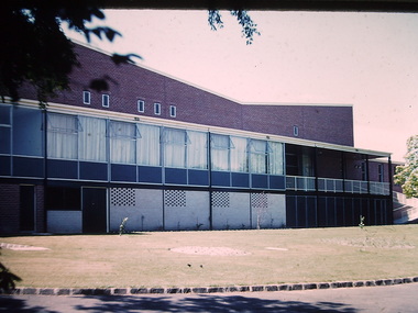
 Kew Historical Society Inc
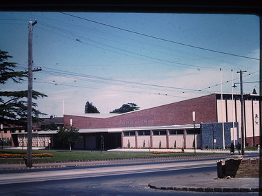
Photograph - Kew City Hall, Ron Setford, 1960
... The Kew City Hall in Cotham Road, designed by Harold... Hall in Cotham Road, designed by Harold Bartlett, was intended ...Ron Setford and his wife Grace Setford lived in Tanner Avenue, East Kew, from c.1946 to c.1995. A keen photographer, he recorded the changing face of Kew over a 20 year period. Apart from 30 photographs of built structures and places in Kew dating from 1960 and 1961, 145 of his 35mm colour slides chronicle the development of the Eastern Freeway through the Yarra Valley over a five year period from c.1972 to c.1977. This important collection was donated to the Society by his granddaughter in 2025.This collection of 175 35mm slides is of local and statewide significance, owing to its subject matter, particularly the major development of road transport infrastructure during the 1970s with the construction of the Eastern Freeway. The photographer also took care to annotate and date most of his slides which enable the researcher to pinpoint temporal and spatial locations.The Kew City Hall in Cotham Road, designed by Harold Bartlett, was intended as the initial phase in a scheme to develop an entire civic precinct. This was representative of a widely-held belief, of the immediate post-war era, that a district's civic centre should be precisely that – not just a single grand building for official use, but a dedicated precinct providing a range of community facilities as well as an administrative function. The Kew masterplan was later abandoned. The City Hall was designed to cater for public or official functions. Its interior had a small stage at one end for intimate theatrical productions, a larger stage at the other (with sunken orchestra pit) for musical performances, plus the most up-to-date equipment for live TV transmission."Kew Town Hall"ron setford, photographs -- kew (vic.) -- 1960s, kew town hall -
 Kew Historical Society Inc
Photograph - Kew City Hall, Ron Setford, 1960
... The Kew City Hall in Cotham Road, designed by Harold... in Cotham Road, designed by Harold Bartlett, was intended ...Ron Setford and his wife Grace Setford lived in Tanner Avenue, East Kew, from c.1946 to c.1995. A keen photographer, he recorded the changing face of Kew over a 20 year period. Apart from 30 photographs of built structures and places in Kew dating from 1960 and 1961, 145 of his 35mm colour slides chronicle the development of the Eastern Freeway through the Yarra Valley over a five year period from c.1972 to c.1977. This important collection was donated to the Society by his granddaughter in 2025.This collection of 175 35mm slides is of local and statewide significance, owing to its subject matter, particularly the major development of road transport infrastructure during the 1970s with the construction of the Eastern Freeway. The photographer also took care to annotate and date most of his slides which enable the researcher to pinpoint temporal and spatial locations.The Kew City Hall in Cotham Road, designed by Harold Bartlett, was intended as the initial phase in a scheme to develop an entire civic precinct. This was representative of a widely-held belief, of the immediate post-war era, that a district's civic centre should be precisely that – not just a single grand building for official use, but a dedicated precinct providing a range of community facilities as well as an administrative function. The Kew masterplan was later abandoned. The City Hall was designed to cater for public or official functions. Its interior had a small stage at one end for intimate theatrical productions, a larger stage at the other (with sunken orchestra pit) for musical performances, plus the most up-to-date equipment for live TV transmission.Nilron setford, photographs -- kew (vic.) -- 1960s, kew town hall -
 Kew Historical Society Inc
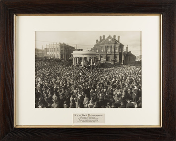
Photograph, The Sears Studio, Kew War Memorial: Ceremony of Unveiling by Sir Excellency the Governor Earl of Stradbroke KCMG, Sunday 30th August 1925
The original, very large framed photograph of the ceremony of Unveiling of the Kew War Memorial, by His Excellency the Governor, Earl of Stradbroke KCMG, Sunday 30 August 1925. At the ceremony there were over five thousand in attendance crowding the intersection of High Street and Cotham Road. The voices of the Governor and the Mayor, Councillor Jabez Carnegie were amplified from four loud speakers on the dome of the memorial. A guard of honour from the 39th Battalion C.M.F. was present, together with the First Kew Troop of Boy Scouts. Restoration of the work by staff at the Grimwade Centre has been made possible by a contribution from Andrew McIntosh M.L.A.Iconic Australian photograph from the post-WW1 period. Nationally significant work reflecting how societies of the time invested social and spiritual values in commemorations of wartime.Framed large photograph. Kew War Memorial : Ceremony of Unveiling by His Excellency the Governor Earl of Stradbroke KCMG, Sunday 30th August 1925. Image of framed photo taken after cleaning and restoration by Grimwade Conservation Services. Digitally cleaned image included in carousel.Kew War Memorial: Ceremony of Unveiling by Sir Excellency the Governor Earl of Stradbroke KCMG, Sunday 30th August 1925 / Sears Studiokew war memorial - 1925, civic collection, sears studio, kew town hall -
 Kew Historical Society Inc
Photograph - Kew City Hall, Ron Setford
... The Kew City Hall in Cotham Road, designed by Harold... -- Kew (Vic.) -- 1960s Nil The Kew City Hall in Cotham Road ...Ron Setford and his wife Grace Setford lived in Tanner Avenue, East Kew, from c.1946 to c.1995. A keen photographer, he recorded the changing face of Kew over a 20 year period. Apart from 30 photographs of built structures and places in Kew dating from 1960 and 1961, 145 of his 35mm colour slides chronicle the development of the Eastern Freeway through the Yarra Valley over a five year period from c.1972 to c.1977. This important collection was donated to the Society by his granddaughter in 2025.This collection of 175 35mm slides is of local and statewide significance, owing to its subject matter, particularly the major development of road transport infrastructure during the 1970s with the construction of the Eastern Freeway. The photographer also took care to annotate and date most of his slides which enable the researcher to pinpoint temporal and spatial locations.The Kew City Hall in Cotham Road, designed by Harold Bartlett, was intended as the initial phase in a scheme to develop an entire civic precinct. This was representative of a widely-held belief, of the immediate post-war era, that a district's civic centre should be precisely that – not just a single grand building for official use, but a dedicated precinct providing a range of community facilities as well as an administrative function. The Kew masterplan was later abandoned. The City Hall was designed to cater for public or official functions. Its interior had a small stage at one end for intimate theatrical productions, a larger stage at the other (with sunken orchestra pit) for musical performances, plus the most up-to-date equipment for live TV transmission.Nilron setford, photographs -- kew (vic.) -- 1960s -
 Melbourne Tram Museum
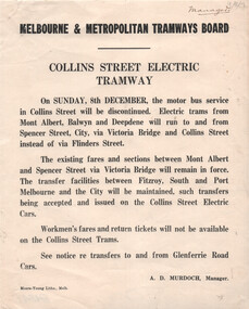
Document, Melbourne & Metropolitan Tramways Board (MMTB), "Collins Street Electric Tramway", Dec. 1929
Set of two Notices to Passengers regarding changes resulting from the opening of the Collins St electric lines to Victoria Bridge as of 8/12/1929. Signed by A D Murdoch, Manager. 1 - Collins St Electric Tramway - noting that the bus service will be discontinued, and electric trams to Victoria Bridge. Existing fares remain applicable but no workmen's fares. 2 - St Kilda Beach - Kew Route - trams will terminate at Glenferrie and Cotham Roads, rather than running to Victoria Bridge. Details fares for the route.Yields information about the opening of the Collins St electric tram service in 1929 and other changes.Set of two Notices printed on quarto paper.Both have "Manager" in top right hand corner.tramways, buses, new tramway, collins st, tram routes, kew -
 Kew Historical Society Inc
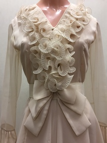
Clothing - Silk Organza Wedding Dress, Oggi Fashion House, 1971
... Presbyterian Church in Cotham Road, where the Rev. Peter Mackie... Presbyterian Church in Cotham Road, where the Rev. Peter Mackie ...Fashion by Oggi, as the sign above the door proclaimed, was located at the Paris End of Collins Street, on the south side, virtually opposite Lilian Weightman’s Le Louvre boutique. Janet Brock, who at the time was working in the Central Business District of Melbourne, had stopped to admire a mauve version of the dress that was displayed in the window, and, on making inquiries from the proprietress, ordered a made-to-measure cream-coloured copy. Her marriage occurred shortly after the death of her father, and took place on 18 December 1971 at the Kew Presbyterian Church in Cotham Road, where the Rev. Peter Mackie was the celebrant. The Fashion & Design collection of the Kew Historical Society includes examples of women’s, men’s, children’s and infants’ clothing from the 18th, 19th and 20th centuries. Items in the collection were largely produced for, or purchased by women in Melbourne, and includes examples of outerwear, protective wear, nightwear, underwear and costume accessories.Wedding dress, purchased by Janet Elizabeth Brock in December 1971 from Oggi of Collins Street. The wedding dress, reaching just below the knee, is lined in silk with a double outer layer of organza. The striking decoration of the monochromatic cream dress is achieved through the use of wide ruffled organza frills at the neck, on the sleeves and at the flared hem of the dress. The dress has a discrete v-neckline with small, self-covered buttons at centre front. At the back, the dress is closed with a nylon zip. In addition to the elaborate stiffened frills, the dress features a wide fabric belt with a double bow, worn at the front. oggi - 103-105 collins street - melbourne (vic), women's clothing, wedding dresses, janet (brock) walker, australian fashion - 1970s