Showing 23070 items matching "creek"
-
 Whitehorse Historical Society Inc.
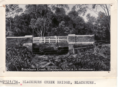
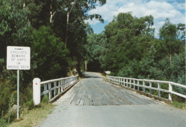
Photograph - Postcard, Blackburn Creek Bridge Blackburn
Black and white postcard entitled Blackburn Creek Blackburn. (in midsummer)|Shows Blackburn Road Bridgeblackburn road bridge, blackburn -
 Otway Districts Historical Society
Photograph, Beechy: At 10 mile creek, 1900
At 10 mile creek (Water Tanks) during the building of the Colac-Beech Forest railway in 1900.colac; beech forest; railway; 10 mile creek; water tanks; -
 Ballarat Heritage Services
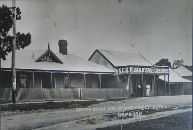
Photograph - Photograph - Black and White, Savoia House and Spring Creek Hotel
Now known as the Savoia Hotel, the original Savoia House is still present behind a new brick front. Black and white photograph of Savoia House and Spring Creek Hotel, Main Road, Hepburn Springs. savoia house, savoia hotel, spring creek hotel, k.c.b. mclaoughlin, hotels, hepburn springs -
 Linton and District Historical Society Inc
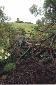
Photograph, Damaged bridge over Springdallah Creek, Happy Valley/Piggoreet, 2010
Already in a dilapidated condition, this bridge was further damaged by floodwaters in 2010 and 2011. In 2025, little remains of the old bridge.Colour photograph showing damage to a trestle bridge spanning Springdallah Creek, Linton-Piggoreet Road.Text, handwritten reverse: 'WE CLIMBED THE HILL / TO PHOTOGRAPH THE / BRIDGE AT EYE LEVEL. / YOU CAN SEE THE / PLANKS (AND WHERE THOSE / MISSING) AND THE / SIDE RAILS.trestle bridges, old springdallah bridge -
 Whitehorse Historical Society Inc.
Photograph - B/W Photograph, Bridge at Deep Creek Road Mitcham. Circa 1940
Black and white photo of bridge at Deep Creek Road, Mitcham which leads to Loughnan's Hill.deep creek road, mitcham, bridge -
 Lakes Entrance Historical Society
Photograph - Bonang Highway, East Gippsland Victoria, Marie Fish, Martins Creek Bridge, 1990 c
Colour photograph of wooden bridge over Martins Creek on Bonang Highway East Gippsland Victoriabridges, riv, roads and streets, engineering -
 Surrey Hills Historical Society Collection
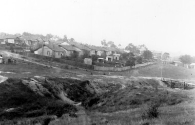
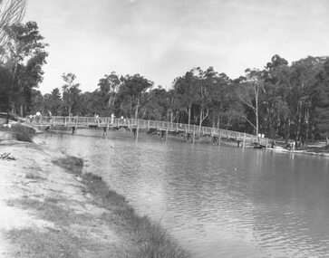
Photograph, Back Creek (later South Surrey Park), c 1936, 1936
This photo was taken at the opening of the footbridge by Sir Winston Dugan in 1936.South Surrey Park was developed on land which had been the property of the Kleinert family. Their land extended from Union Road to Essex Road. They ran horses, ducks and fowls and Emily Kleinert grew flowers. Alan Holt research: Lot 6 was sold to Martin Klienert by Karl Richter in 1860 together with a portion of another adjacent lot. From 1860-1885 Martin worked it as a market garden leasing some land for grazing when it was not required for gardening. He died in 1898. In a formal document, William declared he was the son of Martin "who purchased land in 1860, died in 1898 and the land has been continually occupied by father and family since. It has been cultivated as a market garden; when not being used for gardening it was let for cultivation and grazing." William died in 1939 and the property passed to his sons Martin and Ernest. The family sold the land to the Camberwell Council in the 1950s.This photo is significant as it shows the transition from rural to urban land use in Surrey Hills.Black and white photo taken in the area later known as South Surrey Park. Back Creek is in the foreground. There is a tent on the LHS and approximately 7 houses which front Verdun Street. Some of their backyards face onto the open space along the creek bed.parks and reserves, creeks, south surrey park, civic occasion, official events, back creek, verdun street, 1936, kleinert family, sir winston dugan, topography -
 Surrey Hills Historical Society Collection
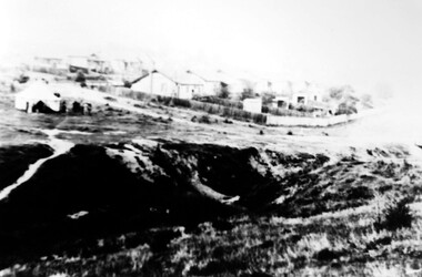
Photograph, Back Creek (later South Surrey Park), c 1936, 1936
This photo was taken at the opening of the footbridge by Sir Winston Dugan in 1936.South Surrey Park was developed on land which had been the property of the Kleinert family. Their land extended from Union Road to Essex Road. They ran horses, ducks and fowls and Emily Kleinert grew flowers. Alan Holt research: Lot 6 was sold to Martin Klienert by Karl Richter in 1860 together with a portion of another adjacent lot. From 1860-1885 Martin worked it as a market garden leasing some land for grazing when it was not required for gardening. He died in 1898. In a formal document, William declared he was the son of Martin "who purchased land in 1860, died in 1898 and the land has been continually occupied by father and family since. It has been cultivated as a market garden; when not being used for gardening it was let for cultivation and grazing." William died in 1939 and the property passed to his sons Martin and Ernest. The family sold the land to the Camberwell Council in the 1950s.This photo is significant as it shows the transition from rural to urban land use in Surrey Hills.Black and white photo taken in the area later known as South Surrey Park. Back Creek is in the foreground. There is a tent on the LHS and approximately 7 houses which front Verdun Street. Some of their backyards face onto the open space along the creek bed.parks and reserves, creeks, south surrey park, civic occasion, official events, back creek, verdun street, 1936, kleinert family, sir winston dugan, topography -
 Falls Creek Historical Society
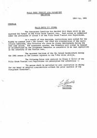
Letter - Falls Creek Ski School
Bob (Herman) Hymans (a former member of the Royal Netherlands Navy) was born in Bloemendaal, Holland on 30th September 1922. During World War II he fought against the Japanese in the Dutch East Indies (now Indonesia) and was imprisoned in Changi and on the Burma Railway. After gaining qualifications as a Ski Instructor, Bob arrived in Falls Creek in July 1950. Working as an Instructor and Supervisor at Bogong Lodge, Bob decided his future was in accommodation. He was successful in negotiating an indenture for land from the State Electricity Commission (SEC). It took Bob two years to build his Grand Coeur Chalet but, tragically, it was burned down in August 1961. Bob also built the first Chairlift in Australia. This was a single chairlift and the structure was built from wooden electricity poles. He was constantly full of new ideas and proposals for the village. Bob Hymans died on 7th July 2007. This Collection of documents and letters tells the story of Bob's endeavours to develop Falls Creek into the ski village it is today.This letter is significant because it documents developments made or endorsed by the Falls Creek Tourist Area Management Committee.A letter from the Management Committee announcing the successful applicant for the operation of the Falls Creek Ski School. The Franchise was awarded to Alpine Developments for the 1961 season, after which time it may be extended or readvertised based on the decision of the Management Committee. The Ski School. The approved location of the Ski School headquarters during the 1961 season was the canteen adjacent to the T-Bar drive station.bob hymans, falls creek tourist area management committee, falls creek garbage disposal -
 Kiewa Valley Historical Society
Papers - Falls Creek Tourist Area Management Committee, August 1984
Falls Creek is a ski resort in the north east of Victoria on the Bogong High Plains. Members of business's (accommodation & restaurants) formed the Falls Creek Chamber of Commerce to promote tourism 'under' the Falls Creek Tourist Area Management Committee. The Falls Creek Tourist Area Management Committee under the direction of the State Electric Commission of Victoria came into effect in 1959 and from then on building sites were leased and building and sewerage controls were applied. In 1979 the Victorian State Government had established the Ski Industry of Victoria working party with a brief report on its operation. These papers give an insight into the business of the Falls Creek Chamber of Commerce in 1984 eg. car parking, noise, closure of the resort due to heavy snow falls, the media and general development of the resort. Local business people are named as attending the meeting indicating many non English surnames. 4 yellowed papers typed on both sides of the first 3 pages. irst paper has 6 items listed re Falls Creek Chamber of Commerce / Sub Committee on General Booking Conditions.Dated 15th August 1984 Next 3 papers dated 13th August 1984 Falls Creek Chamber of Commerce / Minutes of General Meetingfalls creek, ski resort, bogong high plains, falls creek chamber of commerce, snow, ski lodges, -
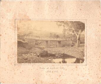 Hume City Civic Collection
Photograph, c1874 - 1880
A photo of a bluestone and timber bridge across the Deep Creek at Lighthouse Creek. There is a man standing on the bridge. The photographer, Alfred Sinel, is listed in the 1874 rate book.A sepia mounted photograph of a bridge at Lighthouse Gully in Deep Creek.written in ink bottom centre: "Bridge at Lighthouse Gully" / Deep Creek. written LH corner of photograph: Photographed by A. Sinelbridges, sunbury, men, clothing and dress, sinel, alfred, photographers, lighthouse gully, deep creek, shire of bulla, george evans collection -
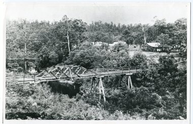 Orbost & District Historical Society
black and white photograph, c1920-1954
This is a copy of "THE BRIDGE AT BOGGY CREEK, NOWA NOWA, LAKE TYERS." which is a Rose Stereograph Co postcard. Boggy Creek Bridge was built in 1916 as part of the Bairnsdale to Orbost extension to the main Gippsland Railway, and is situated in the middle of the township of Nowa Nowa, crossing a steep-sided and well-timbered creek-valley. This section of the line closed in 1987. This bridge plays a major part in the identity and history of the town of Nowa Nowa, This item is associated with the East Gippsland Railway.A large black / white photograph of a large wooden bridge across a creek. There is a house and outbuildings in the background on the right. It is in a bush setting. on back - "Boggy Creek bridge - Nowa Nowa 1887 LaTrobe Collection"boggy-creek-bridge east-gippsland-railway -
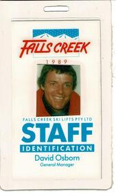 Falls Creek Historical Society
Staff Identification Tag David Osborn 1989
SKI TICKETS Before tows and lifts were introduced at Falls Creek, it could take skiers 20 minutes to climb to the Summit … but only TWO minutes to go back to the bottom. The arrival of tows, then chairlifts and T-bars changed the face of skiing forever. The first rope tow was constructed by Toni St. Elmo for the 1951 winter season. Bob Hymans installed a smaller tow for his guests at Skyline Lodge. Tows were still quite slow, so in 1956 Bob Hymans created his single chairlift. In 1958 the Village rope tow, designed by Albury engineer Jock Wilson, opened. It was financed by shareholders including Bill Griffith (Bowna Ski Club) and the Bridgford family (St. Trinian’s Ski Club). Several other tows followed including the Summit T-bar in 1961, built by Ron McCallum and operated by Alpine Developments Pty. Ltd. which was a company formed by C. H. (Bill) Bridgford. By 1982 Falls Creek was served by 16 different lifts or T-bars, all owned and operated by Alpine Developments (Holdings) Pty. Ltd. During the development of Falls Creek, different methods have been used to pay for the use of tows, lifts and T-bars … including metal tokens, single tickets, strips of tickets and season passes. The Falls Creek Historical Society Collection includes many examples of these items.This Staff Identification Card is significant because it belonged to David Osborn who lead developments at Falls Creek in the late 1980s.A staff identification tag featuring a coloured photograph of David Osborn. He came to Falls Creek to take up the position of General Manager, Falls Creek Ski Lifts Pty. Ltd. He continued in this role until 1990 when he was offered the position of Managing Director at Thredbo. During his period as General Manager major projects carried out at Falls Creek were:- the construction of Halleys Comet Chairlift, Slalom Street Plaza development, the introduction of snowmaking, Cloud 9 Restaurant, the construction of the Scott Chair and the Village Bowl. In 2022 David Osborn released a book, "Falls Creek Stories 1984 - 1990" which documents the developments which occurred in Falls Creek and the people who made them possible.At top: FALLS CREEK 1989 Below photo: FALLS CREEK SKI LIFTS PTY.LTD STAFF IDENTIFICATION David Osborn General Manager chairlift falls creek, david osborn, falls creek development 1980s -
 Ringwood and District Historical Society
Photograph, Ringwood Lake, 1973 previously Sandy Gully Creek (1854)
Typed below photograph, "Ringwood Lake, 1973 previously Sandy Gully Creek (1854). -
 Ringwood and District Historical Society
Photograph, Ringwood Rifle Range, Jumping Creek Road, South Warrandyte, 1959
Black and white photogaph (3 copies)Written on back of photographs, "Ringwood Rifle Range, Jumping Creek, South Warrandyte, 1959". -
 Ringwood and District Historical Society
Photograph, Looking across Mullum Creek to Adelaide Street. Ringwood 1971
Written on back of photograph, "May 1971. Looking across Mullum Creek to Adelaide Street." -
 Ringwood and District Historical Society
Photograph, The surfaced bypass for Mullum Mullum Creek, Warrandyte Road, Ringwood. Possibly 1987
Written on back of photograph, "Date ? The surfaced bypass for Mullum Mullum Creek, Warrandyte Road." -
 Ringwood and District Historical Society
Photographs, 1979-80 MMBW pipe line project at Hubbard Reserve, North Ringwood � The manhole in the creek
Part of a 43-photo record of the MMBW�s engineering feat in drilling a 12 inch pipe line up to 40 feet deep through rock hardened by volcanic action associated with geological fault that occurs along the line. The work took place from October 1979 to May 1980 on the southern boundary of Hubbard Reserve, North Ringwood. The collection was presented to the Ringwood Historical Research Group by J Clarke on 9th June 1980.E563 1 April 1980 A43 The manhole in the creek, waiting until boring is finished. -
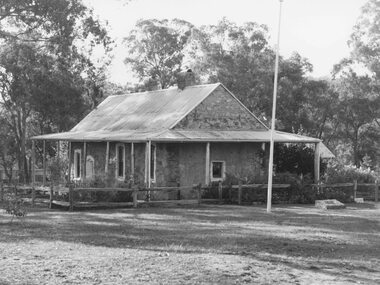
 Stawell Historical Society Inc
Map - Plan, Earle and Partners, Restoration of Pleasant Creek Courthouse Stawell West 1975, 4/8/1975
Designs for Restoration. Includes details for Public Toilet & Trees.A1 Plan of PrecinctDrawing No. 5 4.8.1975. Pleasant Creek Court of Petty Sessions Built in 1860. Museumstawell historical -
 Ringwood and District Historical Society
Photograph, Schwerkolt Cottage, Deep Creek Road, Mitcham - 1964
Black and white photograph- 2 images of front and back entrances of cottage. (2 copies of each image)Written on rear of backing sheet: "Schwerkolt Cottage, Deep Creek Road, Mitcham, 1964." -
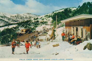 Falls Creek Historical Society
Postcard - Falls Creek Road and Grand Coeur Lodge Annexe
These photographs were taken in and around Falls Creek by Samuel Keith Pearce and printed for him as a foldout postcard by NuColor Vue. The postcards state they were printed for S. K. Pearce Pty. Ltd of Tawonga and Mount Beauty. Samuel Keith Pearce was born on 24 June 1917 in Armadale, Victoria. By the late 1940s he owned the Mt Beauty Supermarket, Newsagency, Drapery and Hardware store at Mount Beauty and also a store at Tawonga in partnership with his brother Gordon Cathew Pearce. For some time, they operated as Pearce Brothers. In the early 1960s Keith also opened a mini mart In Falls Creek. As well as being a keen photographer and an astute businessman, Keith Pearce was a well-known identity in the Kiewa Valley, making many contributions to the development of the area over a long period. This included serving as a member of the Bright Shire Council for many years. He worked hard to promote the interests of the Upper Kiewa Valley. As a sign of recognition and appreciation for his contribution to the community, the park opposite the grocery store in Mount Beauty was named the SK Pearce Gardens in his honour. Samuel Keith Pearce died on 7 July 1994 in Mount Beauty, VictoriaThis collection of postcards and image is significant because they were commissioned by a highly successful business in Falls Creek, Victoria.A high definition photo of Falls Creek Road and Grand Coeur Lodge Annexe. The original Grand Coeur Lodge was built by Bill Hymans between 1950 and 1952. Unfortunately it was burned down in 1961. Grand Coeur was never rebuilt, but Bob modified his annexe to be used as accommodation and later also operated Southern Cross and the Four Seasons. falls creek accommodation, falls creek businesses, grand coeur chalet -
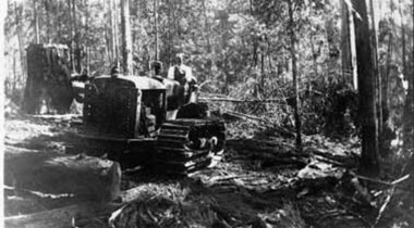 Upper Yarra Museum
Negative Photographic Reproduction, Bulldozer working at Mc Crae Creek mill 1945
Bulldozer working at Mc Crae Creek mill 1945 Black and White negative scanned at 600 dpibuldozer working mc crae creek mill 1945 -
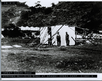 Lorne Historical Society
Photograph, Workmen building shed at Grassy Creek Campsite circa 1920
Photograph circa 1920 showing two men using hand tools, building a shed at Grassy Creek -
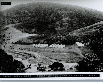 Lorne Historical Society
Photograph, Workers tents at Grassy Creek camp Great Ocean road
Photograph showing rows of tens and utility tents at the construction camp at Grassy Creek on the Great Ocean Road -
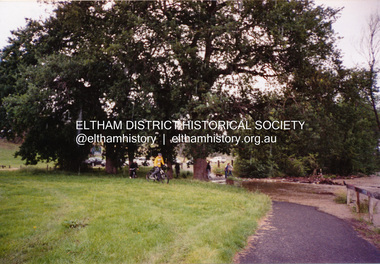
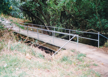 Eltham District Historical Society Inc
Photograph, Doug Orford, Diamond Creek Trail, Eltham
Two colour photographs showing view looking towards and entering footbridge on the Diamond Creek Trail, Elthamwalkways, bridges, diamond creek, eltham, alistair knox park -
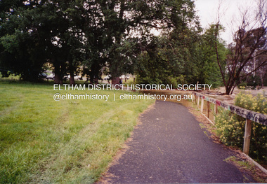
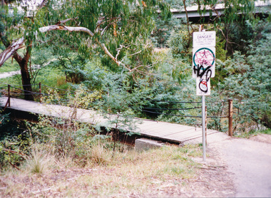 Eltham District Historical Society Inc
Photograph, Doug Orford, Diamond Creek Trail, Eltham
Two colour photographs showing view looking towards and entering footbridge on the Diamond Creek Trail, Elthamwalkways, bridges, diamond creek, eltham -
 Eltham District Historical Society Inc
Photograph, Flooding of Diamond Creek at Lower Eltham Main Road bridge, Nov 2004, 2004
Two colour photographs of the flooded Diamond Creek at the Lower Eltham Main Road bridge in Nov 2004eltham, main road, bridges, diamond creek, floods -
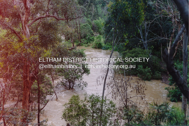
 Eltham District Historical Society Inc
Photograph, Diamond Creek in flood, Eltham, 13 Nov 2004, 13/11/04
Three colour photographs of the floodwater from Diamond Creek crossing the path below the Eltham Community Centre.eltham, diamond creek, floods, eltham community centre -
 Eltham District Historical Society Inc
Photograph, Diamond Creek in flood, Eltham, 13 Nov 2004, 13/11/04
Three colour photographs of the floodwater from Diamond Creek crossing the path below the Eltham Community Centre.eltham, diamond creek, floods, eltham community centre -
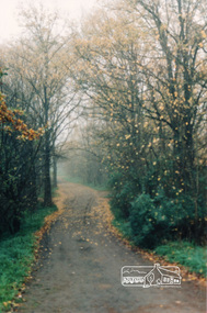 Eltham District Historical Society Inc
Photograph, Diamond Creek Trail, Eltham
Colour photograph of Autumn view of Diamond Creek Trail opposite Dalton Street west of Main Roaddalton street, walkways