Showing 3425 items
matching distance
-
 Lakes Entrance Historical Society
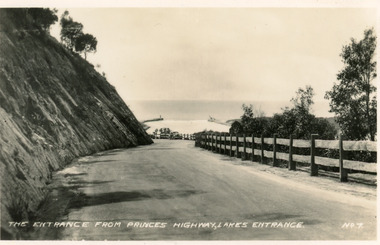
Postcard - Princes Highway Lakes Entrance, Valentine Series, 1940c
Black and white small format postcard of the Princes Highway at Kalimna Hill The road winds between the steep road cutting and a post & rail guard fence. In the distance is the artificial entrance to the Gippsland Lakes. Lakes Entrance VictoriaThe entrance from Princes Highway, Lakes Entranceroads and streets, fences -
 Lakes Entrance Historical Society
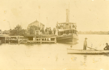
Postcard - S.S. Dargo, 1905 c
Also two other copies, one very dark 15.5 x 23.5 cm, and black and white 16.5 x 25.5 cmSepia postcard showing S.S Dargo at wharf at Paynesville. Stacks of wooden fish boxes on wharf. Several men on wharf and on S S Dargo. Three men in rowing boat. Raymond Island in distance. Paynesville VictoriaS S Dargo Paynesville A Cooper Photoships and shipping, waterways, buildings -
 Lakes Entrance Historical Society
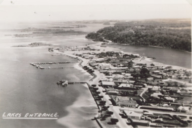
Photograph - Lakes Entrance, 1940c
Also black and white postcard of same view number 03853.1 size 8.5 x 14 cm . c1940Black and white aerial photograph of town looking west from Mechanics Street to Bullock Island with Kalimna escarpment and Rigby Fraser and Flanagan Islands in distance, Avenue of Honour Cypress trees on foreshore Lakes Entrance Victoriaaerial photograph, settlement, caravan parks, camping, ocean -
 Lakes Entrance Historical Society
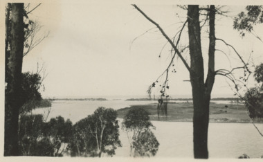
Postcard, Bulmer, Scene from Jemmys Point, 1900 c
Black and white postcard showing view from Jemmys Point of east end of Rigby Island and Reeves channel the entrance and sand dunes with Hope channel in distance Lakes Entrance Victoria.Also another copy of same postcard township, waterways, islands -
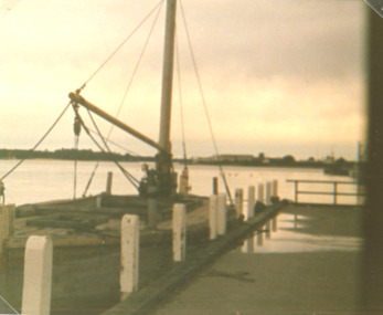 Lakes Entrance Historical Society
Photograph, Vera Bennett, Lady Harriet barge, Lakes Entrance Victoria, 14/06/1989 12:00:00 AM
Also a second photograph showing notice inside barge 04674.1 10 x 15 cmSepia toned photograph showing Lady Harriet barge moored at P.O. wharf on Cunninghame Arm, bullock Island and sand dunes in distance, Lakes Entrance Victoria. Also a second photograph showing notice inside barge Old stone barge that transported stone from Mississippi Creek Auary at the P.O. Jetty 14. 6. 89boats and boating, jetties, waterways -
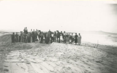 Lakes Entrance Historical Society
Photograph - Snowy River Marlo Victoria
Number 1 in series of fiveBlack and white photographic print showing excavation of an entrance to the ocean at the mouth of the Snowy River with Cape Conran in distance on right. Group of workmen and visitors with horses and scoops on sand Marlo Victoria. Number 1 in series of fivetownship, rivers -
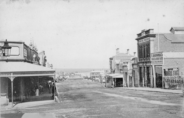 Stawell Historical Society Inc
Photograph, Main Street Stawell looking West from Doyle Lane 1878
Main St. looking West from Doyle Lane. Playford on corner, Whiteside & Co Taylors, Carters Boot Shop. Railway train carriages in distance, Coffee Palace formerly Castlemaine Hotel in distance about centre of photo. Taken c. 1878. , From right of photo T. Brown & Co Timber & Iron Yard, T Brown's Furniture Warehouse, Cambrian Hall, Herbert,s Photographic Studio and Stawell Post Office.Victorian Views. C. Herbert, Photo. Stawell 1878stawell business streetscape -
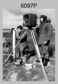 Bendigo Military Museum
Photograph - Army Survey Regiment Personnel – Mahogany Ship Survey, Warrnambool, VIC, 1985
This is a photograph of Army Survey Regiment personnel undertaking surveying measurements during a search for the ‘Mahogany Ship’ Warrnambool, VIC on 3rd September1985. CPL Mark Lander and SGT Don Williams were taking electronic distance measurements using an MRA-301 tellurometer. To measure the distance, personnel at another site operating another MRA-301 tellurometer would have exchanged the signal emission. A ‘Hilga Watts’ light appears in the background and a barometer in the foreground.This is a photograph of Army Survey Regiment personnel undertaking surveying measurements during a search for the ‘Mahogany Ship’ Warrnambool, VIC on 3rd September1985. The photograph was printed on photographic paper and is part of the Army Survey Regiment’s Collection. The photograph was scanned at 300 dpi. L to R: CPL Mark Lander, SGT Don Williams‘R.S. 3/9/1985 CPL Mark Lander, SGT Don Williams PIC BY COURTESY OF THE WARRNAMBOOL STANDARD’ annotated on back of photoroyal australian survey corps, rasvy, army survey regiment, army svy regt, fortuna, asr, surveying -
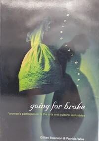 Women's Art Register
Book, Gillian Swanson & Patricia Wise, Going for Broke. Women's Participation in the Arts and Cultural Industries, N/A
Study commissioned by Arts Queensland and the Australia Council in 1994 to address the lack of published information on women's involvement in the arts.BookStudy commissioned by Arts Queensland and the Australia Council in 1994 to address the lack of published information on women's involvement in the arts.regionalism, cultural industraies, equity, professional recognition, indigenous women, multiculturalism -
 City of Ballarat Libraries
Photograph, View north from Sturt Street circa 1876
This view may have been taken from the Gas Works. Buildings shown include the back of the Mechanics' Institute, Chamber of Commerce and in the distance, Railway sheds.streetscape, oblique view, commerical, building, mechanics institute, chamber of commerce, railway, public -
 Stawell Historical Society Inc
Photograph, Main Street Stawell looking East across Wimmera Street to Post Office c1880
Main Street Stawell looking east across Wimmera Street to Post Office. Horse Drawn cart at left of Photo. Star Hotel on right in the distance.B/W Photo Main Street looking east with the Post Office on the left. It is interesting to note that the Star Hotel is way out of line it seems to block the street. It was shifted back and is now the Stawell Club.stawell businesses streetscape -
 Lakes Entrance Historical Society
Photograph - Timber Beacon Gippsland Lakes, 1900 c
On back of original Raymond Island Tambo River in distance. This survey lookout has been washed away, seawater has killed vegetation and allowed erosionBlack and white photograph of a timber beacon on land in Gippsland Lakes in vacinity of Raymond Island Victoriaboats and boating, navigation, waterways -
4th/19th Prince of Wales's Light Horse Regiment Unit History Room
Postcard photograph, c. 1917
A sepia toned postcard photograph of a Light Horse Squadron resting dismounted. The horses are all saddled . Written on lower border: " Awaiting Orders Palestine" Written on back: "Waiting for orders just prior to moving out on a stunt. In the distance you can see an ex Turks or Bedouins domicile". The card is not signed.light horse, palestine -
Port Melbourne Historical & Preservation Society
Plan - Proposed footbridge over the Lagoon, Bridge Street, Port Melbourne, 1863
Plan of proposed footbridge over the Lagoon in line of Bridge StreetIn ink on reverse, two small drawings: elevation land view over a distance of 25.00 chains (colour tinted), and Plan view, section of an unidentified street:In pencil on reverse, notation '107 Albert Street'sandridge lagoon, robert h morgan -
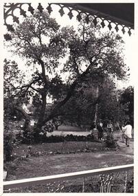 Phillip Island and District Historical Society Inc.
Photograph, Anderson Family
No given information. Obviously a Photograph primarily of a graceful tree. figures not clear enough for identification of place or time.View from a Verandah of unidentified garden depicting a large tree and four people on path to right of Photograph. Photo may have been taken from Glen Isla on the Verandah. In the distance a "For Sale" Notice is visible opposite the garden.local history, photography, photographs, slides, film, unidentified garden, phillip island, black & white photograph, mrs emma anderson jacobs -
Glenelg Shire Council Cultural Collection
Photograph - Photograph - montage on card, Portland, n.d
Four black and white photos attached to grey cardboard a) Bentinck St. looking south, from post office b) 'Burswood' from a distance c) Causeway across Fawthrop Lagoon d) Portland lifeboat in gardens (no shelter)Front: 'Bentinck St, looking from post office' - black ink, handwritten, right of a) '(Burswood) Henty's Old Home' - black ink, handwritten, left of b) '(Causeway)' - black ink, handwritten, left of c) '(Lifeboat) Portland now in gardens' - black ink, handwritten, left of d)portland, streetscape, town -
 Halls Gap & Grampians Historical Society
Photograph - Sepia, c 1876
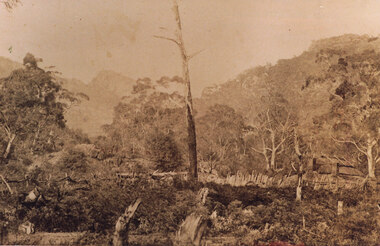
Photo is of Delley's home with the " Watchtower�" in the background. Further information see "Bridging The Gap" p13-14,17,22,54. Records 544 & 545 are enlarged portions of this photo.Photo shows old house to right side of photo. There are two chimneys and the lower half of the house is obscured by a stick fence and undergrowth. The mountain range can be seen faintly in the distance. A dead tree can be seen middle foreground. buildings, houses -
 Bendigo Historical Society Inc.
Photograph - SYMBESTER HOUSE - ELDERBERRY TREE
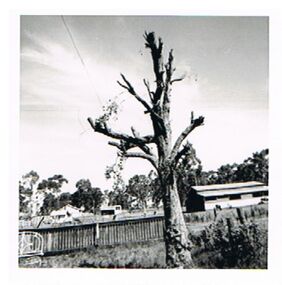
Photograph: black and white photo of Elderberry tree at rear of Symbester House. Tree is almost leafless. In rear of photo is house and shed in distance, panelling fence immediately behind tree, with iron chair (?) visible on LH side of photo.cottage, miners, elderberry tree, symbester house -
 Bendigo Historical Society Inc.
Photograph - TRAIN DERAILMENT COLLECTION: 1961 CULGOA VICTORIA, Wed. 31st May, 1961
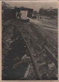
Sepia photograph, a collection, train derailment. A photo of one carriage on it's side with it's spilt load, looks like grain. Some men looking on, two men in the distance. Centre of photo shows the train tracks and the damage.place, train, derailment, photograph, train derailment, culgoa victoria, wed. 31st may, 1961. -
 Port Melbourne Historical & Preservation Society
Photograph - Horse and cart, Normanby Road, 1930s
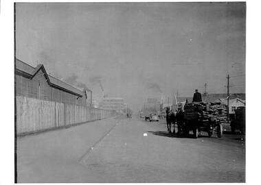
Lasercopy of photograph of horse and cart in Normanby Road, c late 1930s, looking southwest toward Port Melbourne from opposite the dry dock and showing railway sheds on the left and in the distance, Laconia Woollen Mills with Dunlop opposite.transport - horse, dunlop, laconia woollen mills -
 Port Melbourne Historical & Preservation Society
Photograph, James Lauritz, Parkland and the Beacon, 1989 - 1990
Parkland and the Beacon. A temporary extension to Howe Parade is between the park and the beacon. In the distance the area is cleared and ready for redevelopment James Lauritz print of Port Melbourne, laminated (one of 18). Copies of slides produced for Port Melbourne Councillocal government - city of port melbourne, built environment, james lauritz, beacon cove, beacon -
 Port Melbourne Historical & Preservation Society
Photograph, James Lauritz, Stormy evening on Beach Rd, 1989 - 1990
Stormy evening on Beach Rd. Waves crash against the shore and West Gate Bridge in distance is very hazy James LAURITZ print of Port Melbourne, laminated (one of 18). Copies of slides produced for Port Melbourne Councilbeach road, local government - city of port melbourne, built environment, james lauritz, engineering - bridges, west gate bridge -
 Bendigo Historical Society Inc.
Photograph - EVA WILSON COLLECTION: HARGREAVES MALL CONSTRUCTION
Image of Hargreaves Mall, showing McCalmans, McArthurs Shoes, Treasureway, Electricity building (cnr. Williamson and Hargreaves) and Town Hall in distance. Excavation work evident. On back 'Hargreaves St. Mall looking east 14/2/82'place, bendigo, hargreaves mall, bendigo, hargreaves mall, 1982 -
Tatura Irrigation & Wartime Camps Museum
Photograph, Goulburn Waranga Main Channel Construction, 1957
Photo taken by the photographer for Victoria State Rivers and Water Supply Commission of the Goulburn Waranga main channel in 1957.Large black and white photograph - dry mounted to cream board. Channel excavation scene - with excavator bucket in operation / Man operation machine right foreground / Several small indistinct figures mid distance working in channel bed.Below photo: "Goulburn Waranga Main Channel Construction / Bucyrus 200 W. Excavator with 6 c. yd. Bucket / Looking towards off-take at Goulburn Weir / Completed Excavation in Background.goulburn, waranga, irrigation, photo, victoria state rivers and water supply commission -
 Hume City Civic Collection
Photograph
The photo is one of the images from the Eric Boardman collection which is held by the George Evans Museum.A black and white photograph of one of the two bridges which were constructed in the Rupertswood Estate. There are gum trees which have partially hidden the bridge, in the foreground. The railway incline and embankment are across the middle distance and barehills are across the skyline.rupertswood, railway bridges, bridges, rupertswood estate, estates, newspapers, boardman, eric, sunbury news, george evans collection -
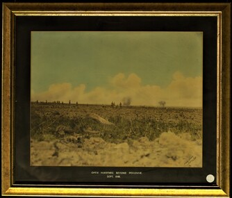 Tramways/East Melbourne RSL Sub Branch - RSL Victoria Listing id: 27511
Print - Picture, Open Warfare Beyond Peronne September 1918
A framed print of a hand coloured photo detailing open warfare in Peronne during WW1. Image shows frontline soldiers witnessing an explosion in the distance. Mat board is inscribed with the words "OPEN WARFARE BEYOND PERONNE. SEPT 1918""Cotarts Studios Melbourne" inscribed on the right corner of the print. open warfare beyond peronne, 1918, september 1918, ww1, explosion, peronne -
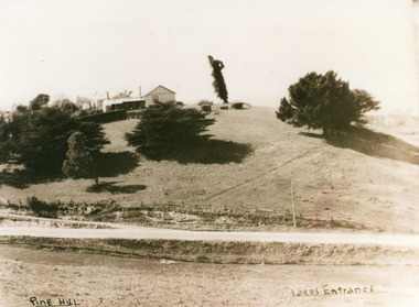 Lakes Entrance Historical Society
Photograph, 1950c
Also second copy which is a very clear photo.Sepia toned photograph of Pine Hill Guesthouse, showing rambling building on top of hill, landmark tree, and pine trees on hillside. Road in foreground is Princes Highway. In far distance a glimpse of Cunninghame Arm. Lakes Entrance VictoriaPine Hill Lakes Entranceguesthouses, roads and streets, topography -
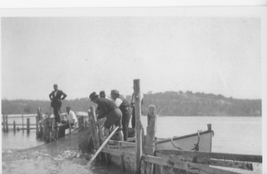 Lakes Entrance Historical Society
Photograph - Fish Pens, 1947 c
Second photograph of two men at fish pensBlack and white photograph of fishermen handling a large net full of fish at the fish pens in the lake inside the western side of the entrance. Two other men on the jetty watching activity, Kalimna Hill in the distance. Lakes Entrance Victoriafishing industry, waterways, fences -
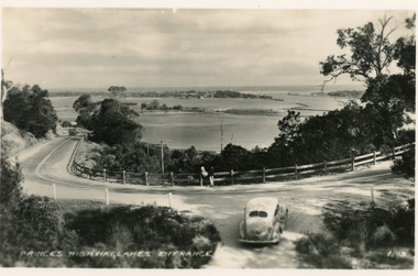 Lakes Entrance Historical Society
Postcard - Princes Highway Kalimna, Valentine Series, 1930c
Black and white postcard of a bend in the Princes Highway as it winds around Jemmys Point, car parked beside highway, two people leaning on post and rail fence, Bullock Island and Lakes Entrance in the distance. Lakes Entrance VictoriaPrinces Highway Lakes Entrancefences, transport, roads and streets -
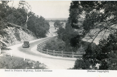 Lakes Entrance Historical Society
Postcard - Princes Highway Kalimna, Bulmer H D, 1935c
Black and white postcard of the Princes Highway as it winds around Jemmys Point. A motor car driving up the hill between steep road cutting and post and rail fence. View of the lake and ocean in the distance. Lakes Entrance VictoriaBend in Princes Highway, Lakes Entrance fences, roads and streets