Showing 15697 items
matching docuents-maps-france
-
 Tatura Irrigation & Wartime Camps Museum
Button
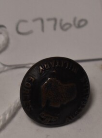
Issued to Sister Kathleen Heaphy of Australian Army Nursing service. Sister Heaphy was attached, for part of her service, to 28 Camp Hospital Internment camp 1.round brass button with a metal shank. Crown and map of Australia and wording around the circumference. A split pin is through the shanks.Australian Military Forces A crown and map of Australia australian army nursing service, sister kathleen heaphy, 28 camp hospital internment camp 1 -
 Whitehorse Historical Society Inc.
Map, Nunawading Shire, 1892
... Maps ...Photocopy of an enlargement of map of Shire of Nunawading showing landowners in 1892.Photocopy of an enlargement of map of Shire of Nunawading showing landowners in 1892. Covers Middleborough Road to Ringwood boundary. One map (Blackburn) from north of Whitehorse Road to Highbury Road, 2nd map (Mitcham) Bulleen to south of Canterbury Road; 3rd map Whitehorse Road to Highbury Road.Photocopy of an enlargement of map of Shire of Nunawading showing landowners in 1892. maps, shire of nunawading, blackburn, blackburn south, nunawading, forest hill, vermont, mitcham, vermont south -
 8th/13th Victorian Mounted Rifles Regimental Collection
Photograph - 13 LH in France
The 13th Light Horse Regiment (AIF) was raised at Broadmeadows Victoria in March 1915. Following service at Gallipoli the regiment was broken up with squadrons going to France as Divisional Cavalry Squadrons of 2nd, 4th and 5th Divisions. The regiment was reformed as firstly 1st Anzac Corps Mounted Troops and later Australian Corps Mounted Troops.Black and white photograph of a section of 13 Light Horse in France.military, wwi, world war one, light horse, france, cavalry -
 Marysville & District Historical Society
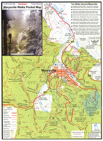
Map (Item) - Pocket map, Rooftop Mapping Services, Rooftop's Marysville Walks Pocket Map, 01-2009
A pocket map of ten walking tracks in an around Marysville. This map was published by Rooftop Mapping Services in January 2009.A pocket map of ten walking tracks in an around Marysville.marysville, victoria, australia, rooftop mapping services, steavenson falls, steavenson falls car park walk, beauty spot walk, marysville to el kanah guest house walk, gilberts gully walk, michaeldene track, man 'o' war walk, tree fern gully walk, marysville to woods lookout to mount gordon walk, keppels lookout walk -
 Robin Boyd Foundation
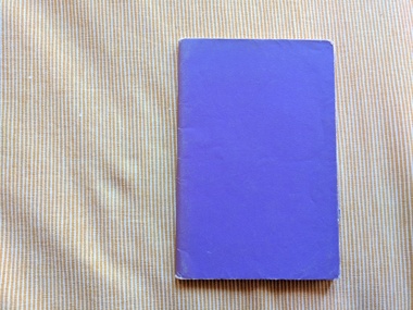
Book, E.C. Kennedy, M.A, Publius : A Roman Boy, 1957
Softcover (Purple paper wrapping)Suzy Boyd (front), French Tests (on the inside back cover), map insert at the start of the bookbritish literature, walsh st library -
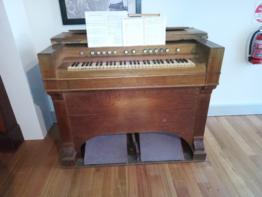 Clunes Museum
Instrument - HARMONIUM
This French harmonium was imported when St. Aquinas Church in Bailey Street, Clunes opened in 1873. a Clunes resident, Mary Lacono played the harmonium in St. Aquinas from 1968 to 2018 French harmonium 14 stops. Formerly St. Aquinas Church in Bailey Street, ClunesNillocal history, mary lacono, st. aquinas -
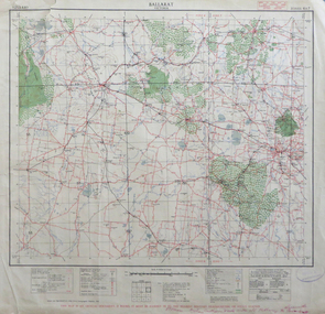 Federation University Historical Collection
Map, Ballarat, Victoria, 1942, 1942
Two copies of a map of the district around Ballarat, including Creswick, Scarsdale, Smythesdale, Lake Bolac, Ararat, Talbot, Sebastopol, Maryborough, Cardigan, Skipton, Mount Emu Creek, Leigh River, Fiery Creek, Hopkins River. Street names are listed on the back of the map. It includes roads, timber, creeks, rivers, telephone lines, railwayPrinted in red at the base of the map "This map is an official document. If found, itmust be handed in to the nearest Military Headquarters or Police Station.ballarat, map, world war two, skipton, creswick, ararat, lake bolac -
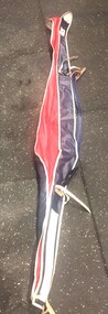 Falls Creek Historical Society
Equipment - Ski Bag, Dynastar, 1960s
In 1963 near the town of Sallanches, France two manufacturing companies formed a partnership to create new high-performance skis. The partnership between Starflex skis, produced by Synthetic Plastics, and Dynamic resulted in the production of Dynastar skis. Available Dynastar products has steadily increased since that time to include a wide range of skis, bags, poles, skins and protective garments and equipment. This bag was used for many years, the last time being for a trip to Canada in 2016.This item is significant because it is representative of ski equipment developed to make travel easier for regular skiers at Falls Creek and throughout the world.A red, white and blue ski bag made from waterproof material with leather straps and metal buckles.Dynastar / Product of Francedynastar, ski bags -
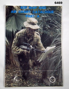 Bendigo Military Museum
Document - ADF Map and Air Chart Catalogue Part A, RASvy Corps, May 1991
This document contains the "map and Air Chart Demand and Issue Voucher" to enable the ordering of map products. The catalogue of available products is shown on the reverse side to assist in the ordering process.1. A Map sheet of Australia folded to A4 in size. 2. A selection of map examples and a catalogue of products, Tactical Line Maps (TLM) at 1:50,000 scale to Digital Chart of the World (DCW) at 1:1,000,000 scale maps. The names of all the 1:100,000 maps are listed in alphabetical order. 3. The Map and Air Chart Demand and Issue Voucher is printed on the back of the document. 4. Front section has a photo of a soldier with a Steyr rifle kneeling reading a map.royal australian survey corps, rasvy, fortuna, army survey regiment, army svy regt, asr -
Woodend RSL
Memorabilia - Trench Art - French Shell Casing Model 1885 37 mm, January 1918
The Canon d'Infanterie de 37 modèle 1916 TRP (37mm mle.1916) was a French infantry support gun, first used during World War I. TRP stands for tir rapide, Puteaux (fast-firing, designed by the Atelier de Puteaux). The tactical purpose of this gun was the destruction of machine gun nests. It was also used on aircraft such as the Beardmore W.B.V and the Salmson-Moineau. Fighter ace René Fonck used a 37mm mle.1916 on a SPAD S.XII.Shell casing - BrassOn the base: PDPs 267 1.18 37-85 (there is a symbol of a flaming bomb between 18 and 37) On the side: "1916 ROBECQ VIMY HAMEL BUSIGNY" On opposite side (in an engraved ribbon starting from the base): A-F-A- - - - 46th Bty - - K.F. KEATING -
Woodend RSL
Memorabilia - Trench Art - French Shell Casing Model 1885 37 mm, January 1918
The Canon d'Infanterie de 37 modèle 1916 TRP (37mm mle.1916) was a French infantry support gun, first used during World War I. TRP stands for tir rapide, Puteaux (fast-firing, designed by the Atelier de Puteaux). The tactical purpose of this gun was the destruction of machine gun nests. It was also used on aircraft such as the Beardmore W.B.V and the Salmson-Moineau. Fighter ace René Fonck used a 37mm mle.1916 on a SPAD S.XII.Shell casing - BrassOn the base: PDPs 267 1.18 37-85 (there is a symbol of a flaming bomb between 18 and 37) On the side: "1917 BULLECOURT MESSINES NIEUPORT YPRES" On opposite side (in an engraved ribbon towards top of casing): K.F. KEATING -
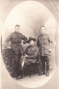
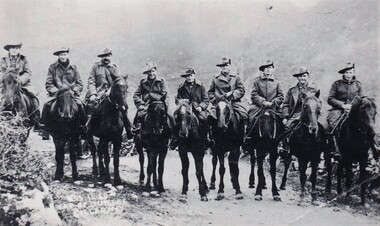 8th/13th Victorian Mounted Rifles Regimental Collection
Photograph
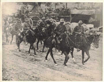
The 13th Light Horse Regiment (AIF) was raised t Broadmeadows Victoria in March 1915. Following service at Gallipoli the regiment was broken up with squadrons going to France as Divisional Cavalry Squadrons of 2nd, 4th and 5ht Divisions. The regiment was reformed as firstly 1st Anzac Corps Mounted Troops and lather Australian Corps Mounted Troops.Black and white photograph of nine soldiers on horseback. All are wearing great coats and possibly there is snow on ground." 13 ALH members France " -
 Flagstaff Hill Maritime Museum and Village
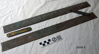
Parallel Rule, Early 20th Century
John Bliss (1795-1857) was born in Norwich Connecticut, trained as a silversmith and clockmaker in Vermont, and began in business as a jeweller in New York around 1830. In 1834, now trading as Bliss & Creighton, he made and marketed a range of nautical instruments. The business subsequently became John Bliss & Son in 1855 and John Bliss & Co. in 1857. It remained in business until 1957 when it was acquired by West Marine. The Bliss company used to make a range of instruments supplied to a variety of customers including the US Navy. An object made as an aid for marine navigation, to plot a course on a nautical map for a vessel to follow. The item was made by a well known American maker of nautical instruments and is significant in regards to it's provenience and history of the maker and his family who over the years had been innovators and makers of various types of nautical instruments since 1795. Parallel map ruler. Bliss of New York & Nautical instruments engraved on face of ruler, ruler divided into degrees for use on nautical mapsflagstaff hill, warrnambool, shipwrecked-coast, flagstaff-hill, flagstaff-hill-maritime-museum, maritime-museum, shipwreck-coast, flagstaff-hill-maritime-village, parallel rule, map reading, nautical object, navigation instrument -
 Peterborough History Group
Document - Explorers of Australian coastline
information pertaining to Captain Cook and French sailor Baudin. Includes French names which he assigned to coastal features.Outlines early European observation of the coastline.Newspaper clipping, copies mapsbaudin, peterborough, peterborough history, le geographe -
 National Wool Museum
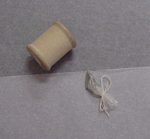
Knitting Nancy
Wooden cotton reel and pins used for French knitting, Samboy knitting, Knitting Nancy, or Corkscrew knitting. (Ref Registration Sheet 89.0085)Wooden cotton reel and pins used for French knitting, Samboy knitting, Knitting Nancy, or Corkscrew knitting.SUPERIOR LINEN THREAD/ 30knitting, knitting french, knitting - french -
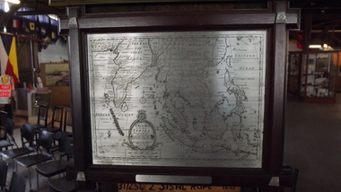 Seaworks Maritime Museum
Selangor Pewtor map of East Indies, Possibly Malaysia, 1993
Selangor Pewter Map of East Indies. Original map was created in 1700s and this reproduced pewter map was based upon originals in the Collection of Muzium Negara, Malaysia. The map is framed in a dark wood frame with pewter flowers decorating each corner. The incisions are far darker than other pewter map.On the verso: PMA0298 Royal Selangar (on frame) Text located on map: ‘A NEW MAP OF THE EAST INDIES…’ ‘Reproduced from the collection of Muzium Negara, Malaysia. Selangar Pewter.’ On plaque: ‘IN COMMEMORATION OF/ THE MAIDEN VOYAGE OF EUROPEAN EXPRESS TO MELBOURNE/16th Sep 1993’ Sticker at top of frame stating ‘MISC.’gifts -
Beechworth RSL Sub-Branch
Map confidential
Map covering the area south of Saigon shows the following AO's Duc Thanh, Debonah, Sadue, Xuyen Moc &Nui Nhon, Janette, Vung Tau special Zone and small arm ChristineExplanation of basic map reading south of saigon -
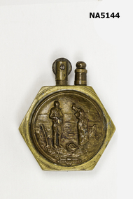 Whitehorse Historical Society Inc.
Functional object - Cigarette Lighter, Brass/bronze hexagon, Unknown
Fabricated French art made from found military components,Example of use of found material relating conflict.A brass/bronze hexagon cigarette lighter made from brass nut with bronze medallions inserted either side.Side A - L' Angelos painting (1859) Side B - Coin (?) Frenchexample of french art -
 Orbost & District Historical Society
drawing - graphic, Mr Brodribb's Maize Shelter, 6.8.1918
Newspaper found inside frame backing dated Tues, Nov,12 1918. Harry French was a well known architect in Bairnsdale for over 40 years. Harry French of Bairnsdale was A. J. Macdonald's supervising architect for Bairnsdale Court House built in 1893.This drawing is significant for its connection to the Brodribb family. The architect, Harry French, was a well-known Bairnsdale architect. Maize has been a major crop in the Orbost district since the late 19th century.Graphic illustration of Mr H Brodribb's maize shelter to half inch scale. In glass with wooden frame.H French A-R-V-I-A- Bairnsdale 6-8-1918drawing civil-engineering drafting rural-industry agriculture maize brodribb -
 Kiewa Valley Historical Society
Maps - Kiewa Valley Parish Maps x3 and Kiewa Area Planimetric Map x1
Planimetric maps are 2 dimensional representations of the Earth's surface, showing the location and spatial arrangement of features such as roads, buildings, and bodies of water. The parish maps show the occupiers with leases or licences of the land. These are updated by the Department of Lands regularly. The names of early settlers of the Kiewa Valley occupying land by lease or licence are shown. Many of these familie's descendants still live in the Kiewa Valley.1. Kiewa Area Planimetric Map (photo) 2. Wermatong, County of Bogong Parish Map 3. Mulllindolingong, County of Bogong Parish Map 4. Mullagong, County of Bogong Parish Map All black and white kiewa valley. parish maps. land owners -
Whitehorse Historical Society Inc.
Map, Blackburn and Nunawading Map, 1960's?
... Maps ...Map of Blackburn and Nunawading.Map of Blackburn and Nunawading.Map of Blackburn and Nunawading.maps, blackburn, nunawading -
Creswick Campus Historical Collection - University of Melbourne
Document, Forests Commission Victoria, A list of rare, very localised and endangered indigenous plants of Victoria, c.1982
1 Booklet and 29 maps in boxed set.Maps and Booklet -
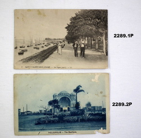 Bendigo Military Museum
Postcard - POSTCARDS WW1, C. 1915 - 1918
The cards sent between 1915 - 1918 from various locations in Egypt and France. Sent by Thomas Comini to Una Frankling. Refer Cat No 2380 for details re Thomas Comini.Six postcards, rectangular shape, variations of colour relating to Eygpt and France, rear has text.postcards, france, eygpt -
 8th/13th Victorian Mounted Rifles Regimental Collection
Photograph
235 Trooper A. Gray of Edenhope Vic. The 13th Light Horse Regiment (AIF) was raised t Broadmeadows Victoria in March 1915. Following service at Gallipoli the regiment was broken up with squadrons going to France as Divisional Cavalry Squadrons of 2nd, 4th and 5ht Divisions. The regiment was reformed as firstly 1st Anzac Corps Mounted Troops and lather Australian Corps Mounted Troops. Black and white photograph of 3 soldiers, one sitting, two standing, of the 13th Light Horse." A Gray 13 ALH France " -
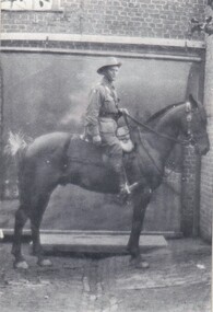 8th/13th Victorian Mounted Rifles Regimental Collection
Photograph
69 Corporal Eric Thewlis. The 13th Light Horse Regiment (AIF) was raised t Broadmeadows Victoria in March 1915. Following service at Gallipoli the regiment was broken up with squadrons going to France as Divisional Cavalry Squadrons of 2nd, 4th and 5ht Divisions. The regiment was reformed as firstly 1st Anzac Corps Mounted Troops and lather Australian Corps Mounted Troops.Black and white photograph of a soldier on horseback outside a brick building." E. Thewlis France 22.9.1916 " -
Melbourne Tram Museum
Map - Metlink folder - Travel Smart Maps, Travelsmart - Department of Infrastructure, "Melbourne's Public transport Map", 2005 to 2006
... maps ...Set of four maps issued by Metlink - 2005 to 2006 contained within a Metlank badge plastic folder. Maps published in association with Melway 1 - 5 x 8 fold map with card cover dated Jan 2005 with a price of $2. Detailed map showing rail, tram and bus routes. 2 - 6 x 4 fold map for Moonee Valley - Travelsmart - for public transport, walking and cycling - dated 2005 3 - 7 x 4 fold map for Moreland - Travelsmart - for public transport, walking and cycling - dated October 2006 - includes notes on taxis. 4 - 7 x 4 fold map for Ride to Work day - 5 Oct. 2005Yields information about Melbourne Public Transport network.Metlink plastic folder containing maps.maps, metlink, public transport, moreland, moonee valley, travelsmart -
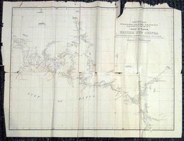 Federation University Historical Collection
Map, British New Guinea, 1893, 1893
The map was surveyed by ship compass, distances by estimation or rate of launch by officers of the Government ; supervised and compiled by J.B. Cameron, G.S. March 1893. This map was in the possession of Charles Carty Salmon (1860-1917), politician, born on 27 July 1860 at Amherst, Victoria. (http://adb.anu.edu.au/biography/salmon-charles-carty-8328 ) Although living in Melbourne Charles Carty Salmon kept property at Talbot. The property was leased, then purchased by the donor's family. A copy of "The Goulburn Weir and its Dependent System of Works" and this map (in a government envelope addressed to Salmon) were left at the property. See http://nla.gov.au/nla.map-rm1894-1 .1) Sketch map showing the rivers and an outline of the coast from Long. 144?30'E. to Long. 146?30'E. Gulf of Papua British New Guinea Scale [ca. 1:316,800]. .2) Large envelope addressed to The Hon Charles Carty Salmon M.P., Talbot, Victoria. The map was folded and stored in this envelope. Map extending from Port Bevan to Kaikavau Pt, showing rivers and notes on soil and vegetation. Relief shown by hachures and spot heights. Also available in an electronic version via the Internet at: http://nla.gov.au/nla.map-rm1894-1 .1) "Enclosure in Despatch No. 32 of 3rd May 1893 - Appendix G.". "Map no. 4 British New Guinea report 1892-93". .2) "This envelope can only be lawfully used by Government Officials on public business. Any use by Officials on private business, or by others under any circumstances, is punishable." "Commonwealth Celebrations. General Secretary's Office, Melbourne."carty salmon, charles carty salmon, new guinea, j.b. cameron -
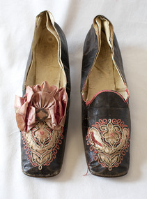 Brighton Historical Society
Shoes, circa 1867
These shoes were worn by Emily Cock (nee Smith), the daughter of wealthy early settler John Matthew Smith. From 1856 until 1931 the Smiths lived at 'Castlefield', a mansion on a vast estate that at one time stretched along South Road from Bluff Road to Hampton Street. The land was gradually subdivided, and the house is now a part of Haileybury College. Julien Mayer was a French ladies shoemaker and prolific exporter who advertised his successes on the shoes themselves by stamping the soles with details of the prizes he had won.Pair of black kid leather shoes with low block heel, decorated with pink silk, cut-away applique and embroidery. Pink bow with metal clasp on one shoe; missing from the other. Edged with pink silk ribbon binding, largely deteriorated.Sole embossed with "MAYER / Julien / à Paris", in addition to tamped with three small medallions proclaiming the awards the shoemaker won in London in 1862, Porto in 1865 and Paris in 1867. Handwritten in interior sole of T0124.2 in pencil: "Emily Smith / Castlefield"emily smith, castlefield, shoes, 1860s, applique, embroidery, julien mayer -
 Otway Districts Historical Society
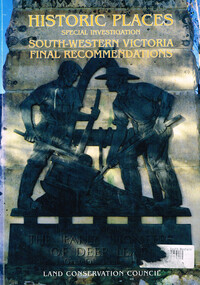
Book, Land Conservation Council, Historic places: special investigation: South-Western Victoria: Final recommendations, January 1997
The Land Conservation Council has carried out an investigation of historic places in public land in South-western Victoria. The report contains the Council's recommendations for the protection, management and future use of more than 700 historic places, out of 2200 places identified during the investigation. The places have been assigned to three categories, A, B and C, representing State, regional and local levels of significance. The report also contains recommendations relating to general historic places management, the processes available in Victoria for the protection of historic places on public land, and Aboriginal historic places.Historic places: Special investigation: South-Western Victoria: Final recommendations. Land Conservation Council. Land Conservation Council; Melbourne (Vic); January 1997. viii, 176 p.; illus.; maps. Soft cover. ISBN 0 7241 9290 5Maps in plastic sleeve.land conservation council; conservation; historic places; public land; aborigines; south west victoria; -
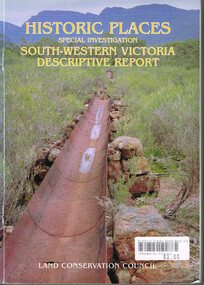 Otway Districts Historical Society
Book, Land Conservation Council, Historic places: Special investigation: South-Western Victoria: Descriptive report, January 1996
The south-west of Victoria, possessing a rich heritage of the signs of past human activity, is fertile ground for an investigation of historic places on public land. This report includes an initial inventory of almost 2000 places. The report outlines the history and the related heritage of the area, describes in some detail its biophysical attributes and introduces the natural resources and present land use. This information provides a context for understanding the origins of the historical features that are observes today.Historic places: Special investigation: South-Western Victoria: Descriptive report. Land Conservation Council. Land Conservation Council; Melbourne (Vic); January 1966. viii, 180 p.; illus.; maps. Soft cover. ISBN 0 7241 9288 3Maps in plastic sleeve.land conservation council; conservation; south-western victoria; historic places;