Showing 1655 items matching "junctions"
-
 Orbost & District Historical Society
albums, late 1980's
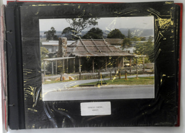
These two albums were used at the Slab Hut - Orbost Visitor Information Centre. The Orbost Visitor Information Centre is situated in Forest Park on Nicholson Street. The centre is housed in the historic Slab Hut. The hut was an original family dwelling built in 1872, on a site approximately three kilometres upstream from the junction of the Buchan and Snowy Rivers. No nails were used in the construction; it was all wired together. After a period in storage the slab hut was opened in its present location in Orbost as the Information Centre in 1987.These albums are contemporary records of the construction and relocation of an iconic Orbost building, the Slab Hut.Two large photo albums. 2280.1 has no front cover. The back cover and spine are red. The pages are black and most photos are labelled. They are photographs of the Orbost area. 2280.2 has brown covers. It contains photographs of the construction of the gardens and buildings around the Slab Hut (Orbost Visitor Information Centre). On the cover in gold print is "PHOTOS".slab-hut-orbost album-photographs-orbost -
 Glen Eira Historical Society
Document - Caulfield Fire Station, No 26, Tree Reserve, Dandenong Road
A three page photocopy of a handwritten memorandum of agreement dated 11/10/1894 between the municipalities of Caulfield and Malvern and the Metropolitan Fire Brigades Board consenting to the erection of a fire station on Tree Reserve. Also a three page photocopy of a handwritten agreement dated 11/10/1894 between owners of properties in the neighbourhood of the junction of Dandenong Road and Waverly Road and the Metropolitan Fire Bridgades Board to allow the Board to erect and use a fire station on Tree Reserve in Dandenong Road. The agreement was signed by the property owners.caulfield east, shire of caulfield, tree reserve, caulfield fire station, rs anderson and son, fire stations, legal documents, lloyd c d, jowett f, delves catherine , catani c, federal building society, st james building society, nathan philip, trustees of the late john nathan, adams j, bates j -
Glen Eira Historical Society
Article - BALACLAVA ROAD, 230-232, CAULFIELD NORTH
This file contains one item: 1/A cutting of an article from the commercial real estate subsection of The Age, dated 13/11/2010, describing a property located at 230-232 Balaclava Road, Balaclava Junction, Caulfield North. The property is commercial, though it is not specified as to whether it is a shopping centre, warehouse, or whatever else. Listed are the building’s size, condition, current rental revenue, parking facilities, nearby amenities, auction date and expected selling price range, as provided by Gross Waddell Real Estate Agency.commercial establishments, balaclava road, hawthorn north, caulfield north, rents and renting, car parks, gross waddell, real estate agencies, gross michael -
 Puffing Billy Railway
Rail Bender No. 3
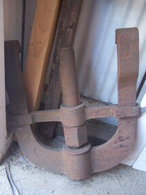
Rail Bender - Part of Hydraulic Rail Bender Rail Bender – No. 3 Most rails are produced straight. While they to easily bend and appear flexible, they are required to bend for some curves, at rail joins on curves and at point (turn-out) junctions. For a safe transition around curves and in the finer areas of the point, this use to be done with a manual rail bender. Sometimes referred to as a Buddah, the rail bender attaches its two claws to the rail. In the middle of the two claws is a screw that is tightened slowly using large spanner. Historic - Railways Permanent Way and Works - track equipment - Rail Bender large Rail Bender - Part of Hydraulic Rail Bender made of cast wrought iron puffing billy, rail bender -
 Melbourne Tram Museum
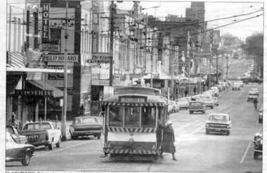
Photograph - W5 class 721 High Street, St Kilda, 1970s
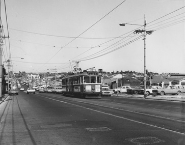
Photograph of W5 class 721 city bound on route 67 ascends an uphill grade on a busy thoroughfare with numerous motor vehicles parked on vacant allotments along the southwest edge of the roadway. This is likely High Street, St Kilda at the commencement of road-widening works in the early 1970s. These works were to widen the narrow High Street between the wider Brighton Road and the newly rebuilt St Kilda Junction. Properties on the northeast edge of High Street remained. In these years the Carnegie route number changed from 4 to 67.Yields information about increase in motor vehicle traffic Black and white photograph with no notetram 721, route 4, route 67, high street st kilda, st kilda junction, road widening, brighton road, w5 class -
 Melbourne Tram Museum
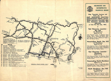
Ephemera - Timetable, Melbourne & Metropolitan Tramways Board (MMTB), East Doncaster Junction, Nunawading North, Jul, 1961
Timetables for specific routes, day of week giving information on tram times at specific time points, route map, sections and fares and organisation address - 616 Little Collins St. Melbourne. 2nd July 1961 1 - East Doncaster Junction, Nunawading North, Blackburn Railway Station, Box Hill Railway Station- Mitcham - Ringwood. 2 - Doncaster Junctioin - Melbourne - route 81 with many supplementary routes - July 1961 3 - Bulleen - City - Garden City routes 15 and 16 - July 1961Demonstrates and early MMTB timetable for bus routes which included extensive details of services.Set of 3 MMTB Bus timetable, folded sheets with maps. Bus routes underlined in blue inktrams, tramways, timetables, tickets, bus services, fares, mmtb, doncaster, ringwood, mitcham, bulleen, garden city, route 15, route 16, route 81 -
 Ballarat Tramway Museum
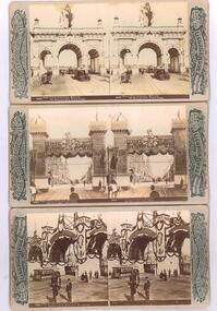
Photograph - Black & White Photograph/s, Rose Stereograph Co, 1901
Photographic reproduction - sepia coloured of a three stereo pair images with details on the sides. Originals made by the Rose Stereoscopic of Melbourne. All 1901 for the Duke of York visit for the opening of Federal Parliament in Melbourne. All feature cable trams. Printed on A4 size ink-jet printer. Set of three: 1 - Duke of York Celebrations, Melbourne, The Municipal Arch, Princes Bridge - image No. 2878 2 - ditto, the Butter Arch, Collins St - image No. 2894 3 - ditto - Prahran and St Kilda Arch, The Junction - image No. 2896.trams, tramways, melbourne, royal visit, cable trams, princes bridge, collins st, st kilda junction, stereo photograph -
 Ballarat Tramway Museum
Newspaper, Alison Wynd, "Ballarat trams must pay their own way: Hiscock", 7/01/1997 12:00:00 AM
Item written by Alison Wynd in The Courier, Ballarat, page 7 on 7/1/1997 reporting on a statement by the Chairman of the Ballarat Tourism Board, Peter Hiscock that trams would have run profitably if they were reintroduced to Ballarat Streets. Comments on possible staging, tourist and engineering studies and market. Includes a photo of SEC No. 31 with a Victoria St. destination at the junction in Bridge St with the Mount Pleasant line, with a women stepping from the tram. An adjacent item reports on the appointment of Robin Cooper as Victorian Transport Minister to replace Mr Alan Brown.feasibility study, ballarat city tramway, ballarat revival, transport minister -
 Ballarat Tramway Museum
Slide - 35mm slide/s, Travis Jeffrey, c1962
Agfa plastic mount (blue base, white cover) of a photograph of No. 20 about to leave the depot. Driver in position? Photo taken c1962. Has other single truck tramcars in the background inside the depot gate. No. 20 has a "Trotting Showgrounds Friday Night" auxiliary board sign on the front of the tram. Photo shows the depot junction lead trackwork in detail. Tram has destination of Sebastopol. Slide rescanned at 3200 dpi 25-10-2020, jpg replaced, tiff file retained. This file was scanned in 2003 and may show colour changes. "BAS 35" in penciltramways, trams, depot junction, depot, auxiliary board, trotting, tram 20 -
 Ballarat Tramway Museum
Slide - 35mm slide/s - set of 5, Eldon Hogan, 20/8/1971?
Set of 5 35mm Agfa colour blue and white plastic mount slide - of a private tour using No. 21 in Ballarat, possibly on 28/8/1971. No. 21 has an SEC roof advertisement, 'Everything is under control in my all electric kitchen". Photo Eldon Hogan Scanning errors on .1, which have resulted in distortions. 3038.1 - No. 21, followed by No. 37, Wendouree Parade, near Haddon St.? .2 - 21 Wendouree Parade, View Point Junction area. .3 - ditto .4 - ditto .5 - ditto tramways, trams, wendouree parade, view point, tram 37, tram 21 -
 Ballarat Tramway Museum
Manual - Procedure, State Electricity Commission of Victoria (SECV), "Graphical Location of Trolley Wire", 1935
Carbon typed copy of a technical procedure - 4 pages -"Graphical Location of Trolley Wire" giving the guide on how to locate trolley wire on curves and junctions, gives formulas, positioning at frogs, notes regarding various cars and trolley wire height. Consists of four pages with a blue print drawing. Each page has been scanned the blue print drawing reversed imaged as well. 4768.2 - the blue print drawing. Extracted from "Transit" Journal - April 1934. Dated 10th Jan. 1935 BTPS Number "226". "226" in ink on left hand bottom of first pagetrams, tramways, overhead, trolley wire, points -
 Ballarat Tramway Museum
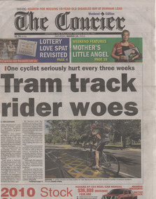
Newspaper, The Courier Ballarat, "Tram track rider woes", "GP seeks action", "I have the answer", Mar. 2011
Yields information about newspaper articles about the problem of cyclists and the tramway rails at depot junction.Two sheets from The Ballarat Courier, regarding issues with the tram tracks at Depot junction and cyclists. .1 - Front page with headline "Tram track rider woes" of The Courier, Ballarat, 19/3/2011 written by Kim Stephens, photo Dominic O'Brien, and on page 2, GP Phillip Dover who was injured after falling off his bicycle. Page 3 - The Courier, 22/3/2011 - "I have the answer", about Kelvin England with a suggestion of a rubber tube in the flangeway, including a photograph. Article by Pat Nolan, Photo Lachlan Bence. depot junction, cyclists -
Ballarat Tramway Museum
Sign, State Electricity Commission of Victoria (SECV), "CARS TAKE FOLLOWING LINE"
Galvanised sheet steel with top & bottom holes(central) & side mounting brackets & rounded corners. Painted with black base and white letters and lines used to indicate which depot track(Line) trams were to be parked or stabled on when returning to the depot. Depot had four under cover tracks (1 to 4) and one outside track ("0") road. Lettered as shown on the sketch on the original worksheet. Reg. Item No. 1170.1? shows the object in a wooden frame mounted onto a pole opposite the depot, by depot junction point.trams, tramways, depot, secv, ballarat, tramcar operations, operations -
 Kew Historical Society Inc
Plan - Subdivision Plan, Windella-Darnley Subdivision, Studley Park, 1920s
Subdivision plans are historically important documents used as evidence of the growth of suburbs in Australia. They frequently provide information about when the land was sold on which a built structure was subsequently constructed as well as evidence relating to surveyors and real estate and financial agents. The numerous subdivision plans in the Kew Historical Society's collection represent working documents, ranging from the initial sketches made in planning a subdivision to printed plans on which auctioneers or agents listed the prices for which individual lots were sold. In a number of cases, the reverse of a subdivision plan in the collection includes a photograph of a house that was also for sale by the agent. These photographs provide significant heritage information relating house design and decoration, fencing and household gardens.Version 1 of two subdivision plans (the later one is MAP.0027) for the section of Studley Park Road near the Junction on the south side. Named in the subdivision are the mansions of Darley and Windella (now demolished). Before the subdivision of Darley and Windella, both houses fronted Studley Park Road. Both houses appear to be advertised as lots in the subdivision. Bisecting the subdivision is a street, Antrim Avenue that was never constructed. A street, which was subsequently constructed in this vicinity, was Merrion Place, which now runs between Studley Park Road and Highfield Grove. There are 14 proposed lots in this subdivision."Antrim Avenue. See over for new plan"subdivision plans - kew, studley park, windella, darnley, studley park road -- kew (vic.), merrion place -- kew (vic.), merrion grove -- kew (vic.), highbury grove -- kew (vic.) -
 Falls Creek Historical Society
Journal - Ski-Horizon Vol 3 No 7
Ski-Horizon is the official journal of the Federation of Victorian Ski Clubs which began publication in 1949. The were 26 original member clubs which included Albury Ski Club, Bogong Ski Club, Myrtleford Ski Club, Tallangatta and District Ski Club and Wangaratta Ski Club. Two pioneers of Falls Creek, Tom Mitchell, M.L.A., and Martin Romuld were Vice-Presidents of the Federation.This Journal is significant because it documents the early development of skiing in Victoria.The journal features stories and events chronicling developments in Victoria and internationally. Items related to the Falls Creek Area in this publication include:- Page 1 reports that Falls Creek members can stay at working bees later on Sundays but must be on the road and have reached Bogong Village by dark. From Falls Creek also comes the news that the snow pole line from Dibbins Hut to Mr. Jim Junction has been overhauled. The shaky ones have been straightened up and 21 new poles placed firmly in position.ski history victoria, federation of victorian ski clubs, road regulations high plains -
 Ballarat Tramway Museum
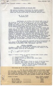
Document - Instruction, Ballarat Tramway Preservation Society (BTPS), "Opening of the Tramway for Revenue Service", 24/12/1974
Original of an instruction and notice that the City of Ballaarat approved the operation of the BTPS in Wendouree Parade from 6pm on 24/12/1974. Signed by Clyde Croft - then Secretary. Also instructs that all trams bound for Carlton St. must stop at depot junction. Notes that first tram ran out at 6pm was tram 26. In very poor condition. On BTPS letterhead, with words "Ballarat Tourist Tramway" along bottom edge. All in green ink. A stamp in black ink "LATE" has been stamped alongside the Secretary's name. Document signed by the Secretary.trams, tramways, btps, operations, city of ballaarat, opening -
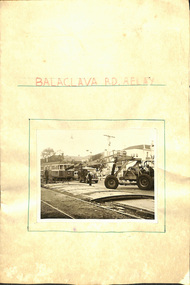 Melbourne Tram Museum
Document - Report, "Balaclava Rd Relay", Late 1964
Report - folded Manila card cover with a photo of W2 480 in the background while temporary track vehicle crossover is being positioned, titled "Balaclava Rd Relay". On the inside is a hand drawn map of the work area from Balaclava Road at Orrong Rd. to St Kilda and some junctions etc Three hand written pages in green ink, glued to the rear cover give dates and details of the work by date from 4-8-1964 to 18-11-1964. On the inside rear cover is a photo of W3 655 on temporary track.trams, tramways, balaclava rd, trackwork, reconstruction, repairs, st kilda, tram 480, tram 655 -
 Melbourne Tram Museum
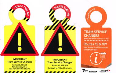
Pamphlet, Public Transport Victoria (PTV), "Tram service changes", 2016
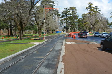
Set of 3 pamphlets or hanging notices to around tram handrails, cut out advised of the changes to services due to tramway or other works. .1 - Route 12 and 109, Sunday 21/2/2016 - 28/2/2016 for the reconstruction of Victoria St between Hoddle and Church St. .2 - Routes 12, 96 and 109 - Sunday 3/1/2016 to 15/1/2016 for the redevelopment of the Clarendon St junction and installation of a Superstops. .3 - Routes 70, 72 and 75 - Saturday 11/6/2016 to 13/6/2016 for trackwork.trams, tramways, trackwork, bus replacement, notices and information, route 12, route 109, route 96, route 70, route 72, route 75, victoria st, clarendon st, superstops, tram stops, tram 3521 -
 Kiewa Valley Historical Society
Photos - Kiewa Hydro Electric Scheme - Kiewa Valley x2
The SECV constructed the Kiewa Hydro Electric SchemePhotos showing the development and history of the Kiewa Hydro Electric Scheme2 copies of 8 small b & w photos. All with titles including "Kiewa Hydro Electric Project". They are in an envelope titled "Valentine's / Snapshots / Eight Real Photographs / Kiewa Valley / Published by /The Valentine Publishing Co. Pty. Ltd / Melbourne and Sydney 1. Kiewa Valley Panorama 2.The East Kiewa River 3. Road to Bogong High Plains 4. Mt Beauty Village 5. Snowfall Bogong Village 6. Bogong Village 7. Junction Dam Spillway, Lake Guy Bogong 8. No 3 Power Station mt beauty, bogong village, bogong high plains, junction dam, power station -
 Ringwood and District Historical Society
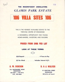
Flyer, Land Sale Brochure, Glamis Park Estate (Wantirna, Vic.) - 1959
Street name Carnarvon Avenue on the subdivision plan became Selkirk Avenue at some stage during or subsequent to development of the Estate.Bi-folded advertisement for sale of residential allotments, including summary of subdivision features and local facilities.Subdivision includes Wantirna streets - Wantirna Road, Carnarvon Avenue, Inchcape Avenue, St Thomas Avenue, St Davids Drive, Dudley Avenue, Angus Avenue. Agents - A.W. Dickson, 136 Whitehorse Road, Ringwood, Telephone WU 6007, WU 7016, A.H. WU 6868. D. & J. Walker, 18 Junction Street, Ringwood, Telephone WU 6516 (all hours). -
 Ballarat Tramway Museum
Photograph - Digital image Set of 28, Mal Rowe, 21/09/2019 12:00:00 AM
Set of 28 digital images of the 2019 Tramcar Showcase by Mal Rowe on 21/9/2019. .1 - View looking south from depot junction showing the track replacement pending the final asphalt layer. .2 - looking north towards depot junction .3 - 27 crossing Wendouree Parade .4 - 14 crossing with John Phillips ex MMTB Mk III Bus in the background. .5 - 13on the access track. .6 - 8 on the depot fan .7 - Cavalcade line up lead by 26 .8 - ditto .9 - group photo being arranged .10 - Cavalcade line up lead by 26 .11 - ditto .12 - 28 returning to the depot. .13 - ditto .14 - 27 returning to the depot on the access track. .15 - 18 ditto .16 - 18 ditto .17 - 13 ditto .18 - 13 ditto .19 - 18 ditto .20 - 40 running in with Mk III bus in the background .21 - 40 on the access track .22 - ditto .23 - 38 on the access track .24 - close up of the 22E truck .25 - depot fan in general. .26 - 14 on the access track .27 - 38 on the access track .28 - 38 dittotrams, tramways, btm, tramcar showcase, events, cavalcade, wendouree parade, trackwork, buses, 22e trucks, depot, tram 13, tram 38, tram 26, tram 14, tram 8, tram 27, tram 14, tram 28, tram 18, tram 27, tram 38, tram 40, tram 671 -
 Melbourne Tram Museum
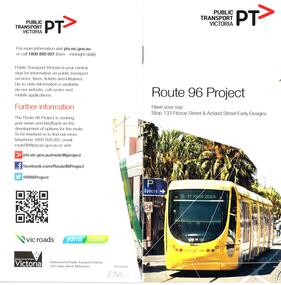
Pamphlet, Public Transport Victoria (PTV), "Route 96 Project", "Route 96 is being upgraded so everyone can catch the tram", 2013 and 2019
Set of 6 documents associated with the provision of low floor tram stop platforms along route 96, East Brunswick to St Kilda. .1 - Pamphlet - 20 pages centre stapled, titled "Route 96 Project - Have your say: Stop 133 Fitzroy St and Acland Street Early designs" Includes a feedback form. Dated 2013. .2 - Drop in DL card - for general update on Nicholson St between Kay Street and Fitzroy North and Brunswick Road. March 2019 .3 - 6 fold A3 to DL - "Route 96 is being upgraded so everyone can catch the tram" - shows the program and map for the provision of 9 stops and timeline. The later was not achieved. 2 copies held. .4 - 6 fold to DL, special size sheet - for the redevelopment of stop 125 Port Junction - shows the siding for the Tramcar Restaurant, and stop 124 at the world trade centre. Dated 2013 .5 - 8 fold to DL - special size paper (has been torn into two), for the Acland St options, and Fitzroy St at the junction with the Light Rail line. Again not all work undertaken. Dated 2013. Have logos of PTV, Yarra Trams and Department of Transport.trams, tramways, route 96, tram stops, fitzroy st, acland st, platform stops, nicholson st, brunswick rd, port junction, clarendon st, whiteman st -
Stawell Historical Society Inc
Map, Stawell Gold Mines Pty Ltd, Plan of Magdala Mine. May 1994, May 1994
Moonlight Junction, Big Newington Co. Pleasants Creek and Newington, Prince Patrick, North Cross Extended, Prince Alfred, Robson and Party, North Magdala, Galatea and Pioneer Co., Duke Magdal, Moonlight, Moonlight Extended, Sliding Shaft, Extended Cross, Crown Cross United, Great Northern, Sloanes and Scotchmans, Marinees, North Waterloo, Scothmans United, Waterloo, Scotchmans Iron Duke and Bulcher, Perthen Shire, Prince of Wales, Roberts, Shafts of Rose of Denmark, Emerald Isle Shafts, O'Donnels, Darlington,, Albion, Federal, Ulster, Goldenpoint and Wexford.AO Printed Map In Colour. Showing Underground Workings and PortalScale 1 : 2500 -
 Bendigo Historical Society Inc.
Document - James Tyson
James Tyson was born in Sydney in 1823. Along with his brother the operated a wholesale and retail butchery in 1852, slaughtering cattle from their property near Balranald. He had worked his way up from farm labouring to droving cattle and initially had a property at the junction of the Lachlan and Murrumbidgee Rivers in 1846. With the discovery of gold he began droving cattle to Bendigo in 1851. He extended his holdings throughout NSW, Gippsland and then into Queensland where he died in 1898. Along the way he had become a millionaire.Nineteen pages of research on James Tyson and family.james tyson, tyson family history -
 Kew Historical Society Inc
Photograph - William John Lamb : Station Master, East Kew Railway Station
William John Lamb (1878-1958) was born in Ballarat, the second oldest of eight children. His father was born in Scotland and had later migrated to Australia. William Lamb lived in Bright Street, Kew, with his daughter. This was possibly his family home. He died in 1958 aged 80. The Outer Circle Railway on which he worked as station master at East Kew connected the Oakleigh and Fairfield Park Stations. The East Kew Station was on the northern end of Harp Road, Kew, near the junction of High Street and Harp Road.outer circle railway, east kew railway station, station masters - outer circle railway -
 Kew Historical Society Inc
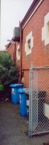
Photograph - Former Kew Police Station : Parking lot, 1996
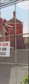
A civic campaign for new public offices developed in Kew in the 1880s. After much deliberation, the location chosen was the junction of Bulleen and Cotham Roads. The buildings were designed by George Watson and John Henry Harvey, architects within the Department of Public Works (Victoria). Building was commenced in 1887, and after one year, the buildings were opened. The Post Office was transferred to the new Commonwealth Government in 1901. The Police Station and Court House, sold by the Victorian Government to the City of Boroondara in 2007, are now a community cultural centre and performing arts venue.The buildings were listed on the Victorian Heritage Register Register (HO885) in 1991. They are historically and architecturally significant to the State of Victoria because Watson and Harvey's designs exhibit diversity in integrating civil offices, they accommodate the apex of road junctions, and they demonstrate a departure from the contemporaneously favoured High Victorian Classical to the Queen Anne style in the design of civic buildings.View through the old wire gates into the parking lot behind the former Kew Police Station and Court House. This was the entrance from Cotham Road with which supplies, prisoners, and police cars would enter.kew court house, public offices -- kew (vic), kew police station -
 Kew Historical Society Inc
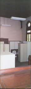
Photograph - Former Kew Court House : Court Room, 1996
A civic campaign for new public offices developed in Kew in the 1880s. After much deliberation, the location chosen was the junction of Bulleen and Cotham Roads. The buildings were designed by George Watson and John Henry Harvey, architects within the Department of Public Works (Victoria). Building was commenced in 1887, and after one year, the buildings were opened. The Post Office was transferred to the new Commonwealth Government in 1901. The Police Station and Court House, sold by the Victorian Government to the City of Boroondara in 2007, are now a community cultural centre and performing arts venue.The buildings were listed on the Victorian Heritage Register Register (HO885) in 1991. They are historically and architecturally significant to the State of Victoria because Watson and Harvey's designs exhibit diversity in integrating civil offices, they accommodate the apex of road junctions, and they demonstrate a departure from the contemporaneously favoured High Victorian Classical to the Queen Anne style in the design of civic buildings.Former court room of the Kew Court House. By 1993 when this photograph was taken, the room had been taken over by the Kew Police Station and used for police lockers and as a briefing room. In the foreground the edge of the magistrates' desk can be seen and in the distance the railing used to separate the public gallery from the main section of the court. This railing was repositioned to the foyer during the renovations of the Court House from 2007-11. The magistrates' desk was destroyed. kew court house, public offices -- kew (vic), kew police station -
 Kew Historical Society Inc
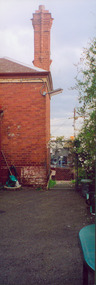
Photograph - Former Kew Police Station : Wall and chimney, 1996
A civic campaign for new public offices developed in Kew in the 1880s. After much deliberation, the location chosen was the junction of Bulleen and Cotham Roads. The buildings were designed by George Watson and John Henry Harvey, architects within the Department of Public Works (Victoria). Building was commenced in 1887, and after one year, the buildings were opened. The Post Office was transferred to the new Commonwealth Government in 1901. The Police Station and Court House, sold by the Victorian Government to the City of Boroondara in 2007, are now a community cultural centre and performing arts venue.The buildings were listed on the Victorian Heritage Register Register (HO885) in 1991. They are historically and architecturally significant to the State of Victoria because Watson and Harvey's designs exhibit diversity in integrating civil offices, they accommodate the apex of road junctions, and they demonstrate a departure from the contemporaneously favoured High Victorian Classical to the Queen Anne style in the design of civic buildings.View through the Cotham Road carpark towards High Street of the southeast corner of the former police station. The use of red brick, tall brick chimneys and slate roof were representative of the Queen Ann Style used in the construction of the Kew Public Offices in 1888.public offices -- kew (vic), kew police station -
 Kew Historical Society Inc
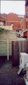
Photograph - Former Kew Court House : Outbuildings, 1996
A civic campaign for new public offices developed in Kew in the 1880s. After much deliberation, the location chosen was the junction of Bulleen and Cotham Roads. The buildings were designed by George Watson and John Henry Harvey, architects within the Department of Public Works (Victoria). Building was commenced in 1887, and after one year, the buildings were opened. The Post Office was transferred to the new Commonwealth Government in 1901. The Police Station and Court House, sold by the Victorian Government to the City of Boroondara in 2007, are now a community cultural centre and performing arts venue.The buildings were listed on the Victorian Heritage Register Register (HO885) in 1991. They are historically and architecturally significant to the State of Victoria because Watson and Harvey's designs exhibit diversity in integrating civil offices, they accommodate the apex of road junctions, and they demonstrate a departure from the contemporaneously favoured High Victorian Classical to the Queen Anne style in the design of civic buildings.View of old weatherboard outbuildings, including a toilet, constructed in the formerly open area behind the Post Office, Court House and Police Station. In the distance is a wall of the former Post Office.kew court house, public offices -- kew (vic), kew police station, kew post office -
 Kew Historical Society Inc
Photograph - Former Kew Post Office : Exterior wall, 1996
A civic campaign for new public offices developed in Kew in the 1880s. After much deliberation, the location chosen was the junction of Bulleen and Cotham Roads. The buildings were designed by George Watson and John Henry Harvey, architects within the Department of Public Works (Victoria). Building was commenced in 1887, and after one year, the buildings were opened. The Post Office was transferred to the new Commonwealth Government in 1901. The Police Station and Court House, sold by the Victorian Government to the City of Boroondara in 2007, are now a community cultural centre and performing arts venue.The buildings were listed on the Victorian Heritage Register Register (HO885) in 1991. They are historically and architecturally significant to the State of Victoria because Watson and Harvey's designs exhibit diversity in integrating civil offices, they accommodate the apex of road junctions, and they demonstrate a departure from the contemporaneously favoured High Victorian Classical to the Queen Anne style in the design of civic buildings.Side wall, facing Cotham Road of the former Kew Post Officekew court house, public offices -- kew (vic), kew police station, kew post office