Showing 726 items
matching land records
-
 Bendigo Historical Society Inc.
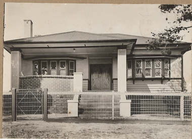
Photograph - T C WATTS & SON COLLECTION: 41 DROUGHT STREET, BENDIGO, 1936
BHS CollectionBlack and white photograph mounted on rectangular brown board. House, weather board below windowsills, rough cast above, two bow windows of 10 lights all leadlighted, twin leadlighted doors, roughcast columns support verandah, front gable, balustraded steps and curved brick wall to verandah. Corrugated iron hipped roof, rough cast chimney with cap of exposed brick. Timber framed fence with woven wire covering and woven wire to gate frame. On back of photo 'Mr. Irwin, Drought Street, sewered £700 for house and land on which it stands 80 x 66 or £875 for house all land through to Stout Street 16.9.36' 2012 photo of house attached to record.Frank H. Jeffree, Photo, Bendigobendigo, business, t c watts and son -
 Eltham District Historical Society Inc
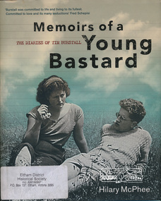
Book, Miegunyah Press, Memoirs of a Young Bastard: the diaries of Tim Burstall compiled by Hilary McPhee, 2012
Diaries of Tim Burstall November 1953 to December 1954. Tim Burstall lived in Eltham. Tim Burstall, the celebrated director of Stork, Alvin Purple and numerous other definitive 'ocker' comedies, is credited with shaking the moribund Australian film industry out of its torpor. But long before that, in the early 1950s, he began keeping a diary to record the world of the group of 'arties' and 'intellectuals' he was living among in Eltham, then a rural area outside Melbourne, where cheap land was available for mudbrick houses and studios, and where suburban rigidities could be mercilessly flouted. Burstall was in his mid-twenties, with two young sons and an open marriage with his wife, Betty. Eager to become a writer, to go against the grain, he kept a record almost daily-of the parties and the talk in pubs and studios, about art and politics and sex, of Communist Party branch meetings and film societies, of political rallies and the first Herald Outdoor Art Show. Somehow, while holding down a public relations job in the Antarctic Division and juggling his love affairs and obsession with the beautiful, brainy Fay, he wrote 500 words almost every day. Betty, according to the diaries, kept the show on the road, feeding friends after the pub, milking goats and working in her pottery making bowls and mugs, which Tim sometimes decorated at weekends. These Memoirs of a Young Bastard, as Burstall dubbed himself and them, are among the most evocative Australian diaries of modern times. Burstall can write. He has an eye for the telling detail, an unerring ear for cant and pomposity and, most endearingly, an ability to mock himself-always from the perspective of a bloke of his generation. Source: Publisherxxiv, 343 p., [18] p. of plates : ill., maps, ports., facsims. ; 27 cm.ISBN 9780522858143diary, motion picture director, film director, author -
 Stawell Historical Society Inc
Book, Stawell Historical Society, Ridgwell George Book 2 - Previously Cat No 3652b, 2000
The family history of George Ridgewell. This Information was mainly obtained from records held by the Stawell Historical Society which comes from various Stawell Papers; from Stawell cemetery records, from baptisms at ST. Patricks Roman Catholic Church, Stawell; from Stawell rate records; from Hotel Licenses and Hotel records; from residential areas obtained under Miners Right and the Land Board; from accounts of Weddings and funerals and from the Victorian Index of Births, deaths & Marriages.Teal Plastic cover and spine on white sticker on spine - George Ridgewell Book 2stawell, family history -
 Ringwood and District Historical Society
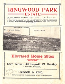
Flyer, Sub-divisional residential land sale advertisement - Ringwood Park Estate, Ringwood, Vic. - circa 1922
Folded double-sided page with black and white photographs of local views with black and red print advertising elevated home sites, including terms of sale, locality map, and description of local facilities and services, with blocks marked as SOLD subsequent to auction sale December 1922. (See Record ID no.5249)Subdivision includes Wonga Road (later Loughnan Road), William Street, Andrew Street, Munro Street and Harrison Street. Estate Agents - Keogh & King, 70 Elizabeth Street, Melbourne, Telephone 6938. -
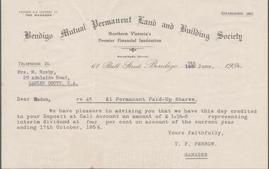 Bendigo Historical Society Inc.
Financial record - EDWIN BUCKLAND COLLECTION: DIVIDEND STATEMENT
Dividend statement from the Bendigo Mutual Permanent Land and Building Society issued on the 5th, June 1956 to Mrs. M. Rusby of Gawler South SApaid up shares, bendigo mutual permanent land & building society -
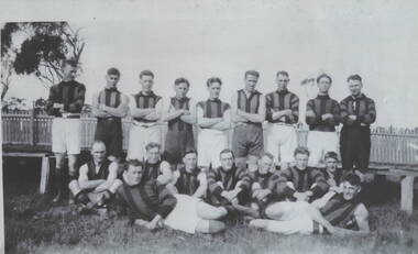 Sunbury Family History and Heritage Society Inc.
Photograph, Sunbury Football team, C 1890s
The first recorded football match played injured Sunbury was in 1881 when Sunbury played Keilor on Munro's Ground which was located on land bordered by Barkly, Shields, Harker and Evans Streets.By 1892 Sunbury Club officially became known as 'The Swifts". A later game was recorded in 1895 but it wasn't until 1897 that it became a recognised football team at a meeting convened by W.A. Eadie in the Royal Hotel. Later football matches were played on railway land in Evans and Macedon Streets. In 1949 the Shire of Bulla Council passed over 26 hectares of Crown land for a new recreation ground, now the Clarke Oval. Since that time that site has been Sunbury's home ground. Sporting clubs have played an important part in the Sunbury's social life from the latter half of the nineteenth century.A non-digital copied black and white photograph of a men's football team standing and seated in two rows in front of a picket fence. sunbury football club, "the swifts', football, sporting clubs -
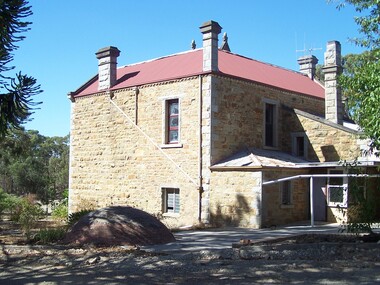 Bendigo Historical Society Inc.
Document - Rocky Vale Beebe House, 2010 to 2015
The Beebe name was well-known in Bendigo in the last quarter of the 19th and the early part of the 20th centuries. From 1875, William Beebe senior, monumental mason, occupied a site in the centre on the city, in Mitchell Street opposite King Street. Death was more part of life in those days, and the Beebes were there to provide the burial monuments. Later, he took his sons into the business, which grew as Beebe and Son. Many examples of their work can be found in the local cemeteries. William Beebe senior (1830-1891) was born in Rutland, the smallest English county in 1830, to stonemason Chamberlain Beebe and Susannah Clements. William emigrated to Victoria in 1854 and after engaging on unknown works in Port Fairy, Dunkeld, and Melbourne arrived in Bendigo. His obituary records that he commenced work here on the site of the Bank of Australasia (opposite the Shamrock Hotel), which would have been no later than 1856. He took up a 13 acre selection on the site of Rocky Vale Villa in 1864 and continued to select or purchase further parcels of adjoining land until he owned some 150 acres, much of it unfit for cultivation. He was a keen gardener and had a garden and orchard around the house. William took over 20 years to build the two-story sandstone and granite house "Rocky Vale Villa". The house was constructed from sandstone sourced "from an adjacent ridge of rocks" (Bendigo Advertiser 28/9/1891). Granite from Harcourt was used for lintels and quoins. Not long before he died, William was still adding to the house. In the Codicil to his will, he states that "I have just built and completed two additional rooms to my Dwelling house situe at Inglewood Road aforesaid" (dated 19/9/1891). William died one week later on the 26th September 1891.Photographs and Historical Documents relating to Rocky Vale Villa, 7 Wicks Road, Maiden Gully, Bendigo by the Bendigo Historical Society.history, bendigo, rocky vale villa maiden gully, william beebe stonemason bendigo -
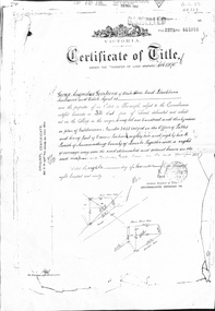 Whitehorse Historical Society Inc.
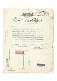
Document - Land Title, Certificate of title, 08/11/1890
Certificate of Title issued to George Augustus Goodwin in 1890 for land between Whitehorse Road and Railway Road, Blackburn together with records of transfers to 1946, the last being to Cottee's Passiona Limited.goodwin, george augustus, shelmerdine, thomas, chrystine, heather blanche, parkinson, basil john, dennis, alexander tregwitha, cottees factory, land sales -
 Lakes Entrance Historical Society
Book, Barrett, Charles and Crampton, Chas. H, Heritage of Stone
... Architecture Land Settlement Religion Bridges Record ...Record of examples of colonial architecture in Tasmaniaarchitecture, land settlement, religion, bridges -
 Bendigo Military Museum
Administrative record - Manual of Land Warfare - RASvy (Draft) by Maj C Watson 1984, Major C Watson, Canberra, 31 Jan 1984
... 1984 Administrative record Manual of Land Warfare - RASvy ...This is a DRAFT document laying out the lines of command and control and duties of RASvy in Land Warfare. The document was prepared by Major C Watson in 31 Jan 1984. The document is missing its Title page. The Title was transcribed from an accompanying document " Technical Reports and papers held by Charlie Watson."26 x paper A4 sized pages of typed text, diagrams and tables held together with an ARNOS fastener. The document is missing its Title page. The Title was transcribed from an accompanying document " Technical Reports and papers held by Charlie Watson."royal australian survey corps, rasvy, fortuna, army survey regiment, army svy regt, asr -
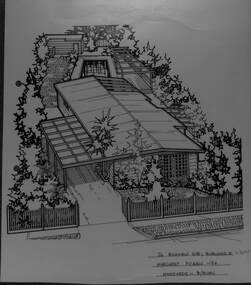
 Whitehorse Historical Society Inc.
Artwork, other - Ink Line Drawing, Margaret Picken, 518 Mitcham Rd., Mitcham, 1995
A property illustration by Margaret Picken Commissioned by a real estate agency for the purpose of advertising 518 Mitcham Rd., Mitcham in 1995. This property demolished has since been subdivided. Made by using Rotring ‘Rapidigraph’ drafting pens with Rotring ink on Rapidigraph polyester drafting film, double matte. Trained as a cartographic draftsman within the mining industry, Margaret Picken is an artist who worked producing property illustrations for real estate agencies in eastern suburbs of Victoria from 1983-2005. Retiring from the industry as technological changes favored coloured photography over illustrations, and commissioning companies over sole contractors.This artwork is of Historical Significance as a record of local domestic architecture.A black ink line drawing on drafters film by Maragret Picken, of An angled elevated view of a single story house situated on a long block of land. A driveway leading off of the street curves to the left of the house and under a connected carport and double garage, as well as through to the backyard to a stand along garage/shed. There are two hole punch holes along the left edge518 Mitcham Rd., Mitcham Margaret Picken - 95 Woodards - C'Wellwhitehorse historical society, schwerkolt cottage, housing, architecture, margaret picken, house, garden, real estate, mitcham -
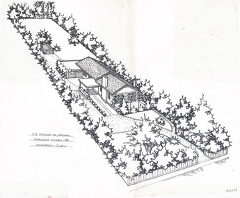
 Whitehorse Historical Society Inc.
Artwork, other - Ink Line Drawing, 26 Highview Gve., Burwood E, 1994
A property illustration by Margaret Picken Commissioned by the real estate agency Fletchers Real Estate for the purpose of advertising 26 Highview Gve., Burwood in 1994 Made by using Rotring ‘Rapidigraph’ drafting pens with Rotring ink on Rapidigraph polyester drafting film, double matte. This property is listed as having sold for $160,250 in 1994 Since being sold the land has been redeveloped, with nothing remaining of the house depicted in this drawing. Trained as a cartographic draftsman within the mining industry, Margaret Picken is an artist who worked producing property illustrations for real estate agencies in eastern suburbs of Victoria from 1983-2005. Retiring from the industry as technological changes favored coloured photography over illustrations, and commissioning companies over sole contractors.This artwork is of Historical Significance as a record of local domestic architecture.A black ink line drawing on drafters film by Margaret Picken, of 26 Highview Gve., Burwood East. An angled birds eye view from the street of a weatherboard house and carport. Extending to the backyards with pool, pagoda, and shed in the background. There are two hole punch holes on near the left edge. There are some crinkles in the paper near the top centre of the work. There is a two centimetre long mark along the centre top edge.26 Highview Gve., Burwood E Margaret Picken -94 Woodards B/Burnwhitehorse historical society, schwerkolt cottage, housing, architecture, margaret picken, burwood, house, garden -
 Bacchus Marsh & District Historical Society
Map, Atkins and Clarke Land Sale situate at Bacchus Marsh 1856 Copy 2
This plan of land allotments for sale indicates the property once owned by the Bacchus family in and around the township area of Bacchus Marsh. The Bacchus family sold their property in Bacchus Marsh to John Atkins and Robert Nalder Clarke in March 1851. Atkins and Clarke kept the property for a number of years until April 1856 when these allotments were put up for sale.This plan is almost identical to another copy held by the Bacchus Marsh and District Historical Society, VC Record 707, BMDHS collection). This plan, VC Record 452 Copy 2, contains a less detail than than VC Record 707 Copy 1. For example the selling agents and the surveyor who created the plan are not indicated on this copy of the plan. This copy of the plan does indicate the name Crook Street on the map. As the Crook family were the buyers of the Manor House property and surrounding land from Atkins and Clarke in 1856 it suggests that this copy is a later one of the earlier version. It is unlikely that the Crook family would have had the adjacent street named after them prior to purchasing the house and property. This is a very early land sales plan for the township of Bacchus Marsh and it therefore provides some clues as to how the early urban development of the township took place. Upon seeing the map in 1911 Bacchus Marsh Express newspaper editor Christopher Crisp wrote "The sale appears to have created the present township, which had a nucleus in earlier times further east", Express, 30 September, 1911, page 3. A single page paper map showing a portions of land available for sale in Bacchus Marsh in 1856. The subdivided land shown was owned by John Atkins and Robert Nalder Clarke, but previously owned by the Bacchus Family and was in and around their Manor House (Mansion) property in Bacchus Marsh.There are 5 portions of land further divided into numerous small portions. The land for sale is bounded by the present day streets of Main Street, Young Street, McFarland Street, Morton Streets, Crook Street, and part of the eastern section extends to the Lerderderg River. Scale: 4 chains to 1 inch. The map is pasted into a bound volume containing 76 maps or plans in total. High resolution digital image stored on BMDHS computer network. Plan of the first portion of land. The property of Messers Atkins and Clarke situate at Bacchus Marsh.land sales, land sales bacchus marsh, manor house bacchus marsh, crook family bacchus marsh -
 Warrnambool and District Historical Society Inc.
Journal - Book, City Poundkeeper's Book, C 1950
This book records the impounding of animals which have been found wandering on local roads or trespassing on land. Many are farm animals and give the various breeds of animals from red Ayrshire cows to bay ponies, and nanny goats. Impounded animals were either claimed by their owners after payment of a fee or if unclaimed , they were sold. The Warrnambool pound was situated on Merrivale Drive.This book is a record of a practice which was necessary to remove stock which were wandering on local roads or trespassing on neighbours. It contains many local names and is of social interest. Rectangular book with hard cover Fawn cloth with red leather spine. Pages are lined in blue and red and pages are headed in black . It dates from 1957 to 1998 with one entry for 2004.Entries are hand written in blue and black. The entries give particulars of the animal impounded and where found with name of council officer and owner, if known, of the animal.various pieces of paper pasted inside front cover.There are many names included in this journal. Among the earlier entries are James P O'KeefeH C Bidmade, Keith Nixon, C Eccles, I Carmody,warrnambool, warrnambool pound -
 Warrnambool and District Historical Society Inc.
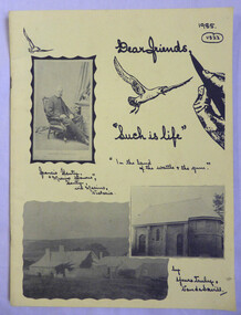
Book - Paperback, Vanda Savill (1913-2005), Such is life, 1985
An example of Vanda Savill's handwritten books documenting western district local histories focussing on the Henty family.This is a paper back book with a yellow cover with black headings and annotations, black and white sketches and black and white photographs. There are 52 pages of handwritten and copied material with photographs and illustrations. The pages are stapled.non-fictionAn example of Vanda Savill's handwritten books documenting western district local histories focussing on the Henty family.henty family, vanda savill, warrnambool -
 Warrnambool and District Historical Society Inc.
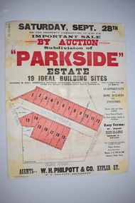
Work on paper - Original Document, H J Paynter, Advertisement "Parkside"Estate subdivision, Circa 1935
This sheet denotes an auction of land which is situated close to Albert Park on the northern part of Warrnambool. The area is complete now with homes which are a mixture of brick and concrete faced houses. The agent W H Philpott was operating in Warrnambool from the 1930's though to 1950'sThis item has local interest and significance as it records the sale of Warrnambool land.Large white paper sheet with black and red text. The auction details are at the top and down the righthand side with a map of the available blocks are coloured red and outlined in black.Parkside estate, W H Philpott & Co Kepler St , R V Philpott auctioneer,Solicitors J S Tait & son. Cramer Street, Nelson Street McConnell Street.warrnambool, mcconnell street warrnambool -
 Ringwood and District Historical Society
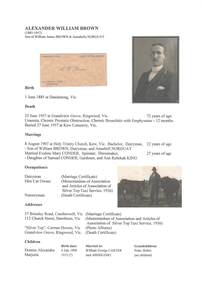
Document - Biography - Family Tree Extract, Alexander William Brown (1885-1957) - Nurseryman, Grandview Grove Ringwood (Warranwood) Vic
A4 folder containing genealogical information, copy of will and copy of probate administration record including real estate assets for A.W. Brown, Grandview Grove Ringwood (Warranwood) Vic.EXTRACT: Inventory of Real Estate Assets (for Probate purposes) 1. Grandview Grove, Ringwood Land containing 10 acres or thereabouts situate in Grandview Grove Ringwood being part of Crown Section 20 Parish of Warrandyte County of Evelyn and being the land described in Certificate of Title Volume 5781 Folio 174 on which is erected a 7 room house, a bungalow, shed and 2 glass houses valued by E. Miles, Ringwood - £5077-0-0 2. Kardinia Crescent, Ringwood Land containing 2 acres 3 roods 24-1/2 perches situate in Kardinia Crescent Ringwood being Lots 33 and 34 on Plan of Subdivision Number 12040 and being part of Crown Section 20 Parish of Warrandyte County of Evelyn and being the land described in Certificate of Title Volume 7141 Folio 080 valued by E. Miles at £350-0-0 -
Clunes Museum
Education kit - DOCUMENT, SOIL CONSERVATION AUTHORITY, MCHUGH'S GULLY - A LAND USE AND MANAGEMENT TEACHING RESOURCE KIT, 1982
ENVIRONMENTAL STUDY OF MCHUGH'S GULLY RECORDED IN THE EARLY 1980'SBUFF COLOURED LEVER ARCH FILE CONTAINING SECTIONS A TO I WITH A CARDBOARD INSERT OF FRONT COVER WITH SEPIA IMAGES OF RURAL SCENES AND TOWN SHIP PRINTED ON IT. Section A contains documents of land use and management teaching resource kit. Section I contains slides and transparenciesnon-fictionENVIRONMENTAL STUDY OF MCHUGH'S GULLY RECORDED IN THE EARLY 1980'Smchughs gully, land management, environmental impact report -
 Ringwood and District Historical Society
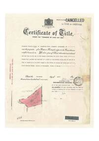
Document, Certificate of Title - Alexander William Brown - part of Crown Section 20, Parish of Warrandyte, County of Evelyn - 16th April, 1948
A4 copies of Landata Victoria Historical Search documents - Vol 7141 Fol 1428080.Alexander William Brown of Grandview Grove (later Bemboka Road), Ringwood is now the proprietor of an Estate in Fee-simple subject to the Encumbrances notified hereunder ... 2 acres 3 roods 24 and one-half perches or thereabouts, being Lots 33 and 34 Kardinia Crescent, on Plan of Subdivision no.12040. Transfers include Alexander William Brown died 25th June, 1957, Probate granted 28th January, 1958, to Alfred Hart Brown of Dandenong, Estate Agent, and Harry Britten Elms of Cardinia, Gentleman, Oliver Burgess, Grandview Grove Ringwood, Florist - 14th May, 1964, Peter John Woodhead, Transport driver, and Shirley Margaret Woodhead, Married woman - 12th September, 1966. Inventory of Real Estate Assets (for Probate purposes 4/10/1957) detailed in Family Genealogy record for A.W. Brown includes: "Kardinia Crescent, Ringwood - Land containing 2 acres 3 roods 24-1/2 perches situate in Kardinia Crescent Ringwood being Lots 33 and 34 on Plan of Subdivision Number 12040 and being part of Crown Section 20 Parish of Warrandyte County of Evelyn and being the land described in Certificate of Title Volume 7141 Folio 080 valued by E. Miles at £350:0:0 -
 Ringwood and District Historical Society
Document, Certificate of Title - Leslie Mills of Plymouth Road, East Ringwood, Farmer - part of Crown Section 20, Parish of Warrandyte, County of Evelyn - 19th January, 1932
A4 copies of Landata Victoria Historical Search documents - Vol 5781 Fol 1156174.Leslie Mills is now the proprietor of an Estate in Fee-simple subject to the Encumbrances notified hereunder ... 10 acres or thereabouts, together with a right of carriage way over Grandview Grove (later Bemboka Road), Warranwood, Victroia. Transfers include Alexander William Brown of Tooradin, Farmer - 29th October, 1945, (died 25th June, 1957), Probate granted 28th January, 1958, to Alfred Hart Brown of Dandenong, Estate Agent, and Harry Britten Elms of Cardinia, Gentleman (*** See Probate details below) Oliver Burgess, Grandview Grove Ringwood, Florist - 14th May, 1964, Privatus Proprietary Limited, St.Kilda Road, Melbourne - 27th October, 1977, John Patrick Kelly, Company Director and Yvonne Gloria Kelly, Married Woman, joint proprietors, 10th September, 1980 *** Inventory of Real Estate Assets (for Probate purposes 4/10/1957) detailed in Family Genealogy record for A.W. Brown includes: "Grandview Grove, Ringwood Land containing 10 acres or thereabouts situate in Grandview Grove Ringwood being part of Crown Section 20 Parish of Warrandyte County of Evelyn and being the land described in Certificate of Title Volume 5781 Folio 174 on which is erected a 7 room house, a bungalow, shed and 2 glass houses valued by E. Miles, Ringwood - £5077-0-0 -
 Bendigo Military Museum
Souvenir - Souvenir Booklet of Land Headquarters Cartographic Company, Australian Survey Corps "Fortuna" Bendigo 1942-45, Land Headquarters Cartographic Company, Australian Survey Corps, 1945
A Souvenir Booklet recording the Section photos and a Nominal roll of those who served 1942-45 at the Land Headquarters Cartographic Company, Australian Survey Corps located at "Fortuna Villa" Bendigo was produced at the end of WWII. Each member of the unit was presented with a copy of the booklet. The booklet besides being a great memory for those who served is a very valuable resource as it names the individuals in the photographs and very importantly records a Nominal Roll of unit members and their Military details. This booklet is one of those original booklets. The booklet has been reprinted on a number of occasions with different coloured covers. The first and original booklet had a red cover. Editions with brown, dark blue and black exist. The black covered edition was the last reprint. This booklet was donated by Carol Hargrave of Grenfell, NSW after discovering it in an old trunk that she purchased. A black covered edition was donated by a local Bendigo Antique Dealer in September 2024.A4 sized red cloth covered hard covered book mainly containing sub-unit photographs of section members and includes their names. 23 x double sided pages of photographs and 2 double sided pages of a Nominal Roll of those who served at Fortuna 1942 - 45. Each of the 50 pages were scanned at 600 dpi in JPEG (.jpg) format and stored on the attached 16GB USB Memory Stick. The images have been converted into MPEG-4 (.mp4) video format, 9Mb in size that runs for 4 Minutes and is also stored on the memory stick.royal australian survey corps, rasvy, fortuna, army survey regiment, army svy regt, asr -
![Painting: Park Street [Adeney Avenue] Kew](/media/collectors/550653872162f11fb04854aa/items/5826877cd0cdd11284ad5413/item-media/614ac683a53a0756fd5e49da/item-fit-380x285.jpg) Kew Historical Society Inc
Kew Historical Society IncPainting, Park Street [Adeney Avenue] Kew, c. 1896
‘Adeney Avenue’ was the title given to this painting following its donation to the Kew Historical Society, yet the work’s origins predate the naming of Adeney Avenue in 1907 [originally gazetted as ‘Park Street’ (1865) and ‘Park Street South’ (1875).] Park Street ran between High Street and Parkhill Road beside what was later to become ‘Victoria Park’. This area was described in 1851 as “…a dense forest of gums and wattles which were to be largely cleared by 1888 after the naming of a recreation reserve”. The Reserve was still bisected by an unnamed creek in 1896, when the area was surveyed by the MMBW. The panoramic vista selected by the artist would appear to include ‘Eborensis’ (c.1895) on the corner of Parkhill Road and what was then Park Street, with views across cleared land towards the distant ranges. In the 19th century, north Kew was largely undeveloped farms stretching down to the Yarra. Oil on canvas by an unidentified artist of a panoramic view depicting what is now known as East Kew with mountains on the horizon. In the foreground is a two storey brick residence - Eborensis - located on the northeast corner of Parkhill Road and what is now Adeney Avenue. The view of the landscape and its rolling hills resulted from farming practices adopted following colonisation and settlement. Trees in the foreground and in the distance include remnant Eucalypts and introduced exotics.Label on rear of frame states "House on corner of Adeney Ave & Parkhill. [Regd. 254"]. Otherwise unsigned and undatedadeney avenue (kew), eborensis, park street (kew) -
 Melbourne Tram Museum
Administrative record - Correspondence, Met Tram, "Letter to all Met Tram Employees", 27/03/1997 12:00:00 AM
Photocopy of a letter, single A4 sheet - "Letter to all Met Tram Employees", signed by Russell Nathan, 27/3/1997 about the sale of Met Bus operations and discussions with PTU regarding a new EBA. Notes Footscray and Sandringham depots would be sold as part of the process.trams, tramways, ptc, met tram, unions, employees, met bus, sale of land, buses, wages -
 Melbourne Tram Museum
Legal record, State of Victoria - Attorney General, "Attorney General of Victoria re Purchase of Essendon Tram Undertaking", 30/06/1922 12:00:00 AM
Legal document within a light brown manila document - titled "Attorney General of Victoria re Purchase of Essendon Tram Undertaking" containing 4 large sheets, typed, legally bound with tape and sewn cotton. Formally titled "The Honourable Arthur Robinson his Majesty's attorney general for the state of the Victoria with Melbourne and Metropolitan Tramways Board / Agreement" Dated 30/6/1922 - sets out the terms and cost of the Board purchasing the undertaking from the State Government (not NMETL), employees except Arthur Murdoch and gives a drawing of the land to be taken over. Agreement scanned. Was subject to Parliamentary approval. Folder has file number "91-2" written on the outside.trams, tramways, mmtb, essendon, nmetl, victorian government, legal agreements -
 Melbourne Tram Museum
Document - report, Norm Wadeson, "Sorrento Tramway", 1961
Notes prepared by Norm Wadeson 1961 from Lands Department Records about the history of the Sorrento Tramway. Has notes on the formation, operation, passengers carried, land, possible extension, deputations to the Minister, Mr George Copin, and closure. See item 7717 for maps and photographs.Yields information about the Sorrento tramway co. and its Lands Department records.Two quarto sheets, typed - stapled in top left hand corner.tramways, tramcars, sorrento, george coppin -
![Map, Ballarat and Gordons Lane Plan of Land required [for railway line work]](/media/collectors/5e461d8021ea67224c82f2a1/items/676ff3a62c3783fe00b96a8d/item-media/676ff4a42c3783fe00b96cb6/item-fit-380x285.jpg) Bacchus Marsh & District Historical Society
Bacchus Marsh & District Historical SocietyMap, Ballarat and Gordons Lane Plan of Land required [for railway line work]
The railway line from Melbourne to Bacchus Marsh was completed in February 1887. After this date work continued to extend the line to Ballan. This map indicates a portion of land only a few hundred metres west of the Bacchus Marsh railway station which would have been among the first stages of the line to Ballan to have been constructed. This suggests the date of this map to be in the late 1880s.Single page map showing land required for railway line work near Griffith Street, Bacchus Marsh. Scale 10 chains to 1 inch. Hand-written on the map are the exact distances between Bacchus Marsh and Gordons (Gordon) and between Bacchus Marsh and Melbourne as measured from the corner of Maddingley Road and Station Street. Distances recorded are in miles, chains and links. The land required for the railway works is marked in red ink and runs through an area known as Kennedy's Gully. Part of a set of maps which are pasted into a bound volume containing 76 maps or plans in total. High resolution digital image stored on BMDHS computer network. bacchus marsh victoria history, maddingley victoria history, railway lines -
Glenelg Shire Council Cultural Collection
Certificate - Certificate of Baptism - James Ward and Thomas Ward, 1854
Displayed in History House.Certified Extract of the Baptism Certificates of James Ward, 12th May 1838 and Thomas James Ward, 4th May 1836 Framed certificate. Page 21 of baptism register for Parish of Launceston in the County of Cornwall, Van Diemen's Land, 1838. Framed with 933.2, Baptism certificate of Thomas James Ward, 4th May 1836. Certified extracts from the Baptismal Registry, 28th June 1854. Carved acorns in frame.Back: Henry Ward Goldsmith/Late of Portland (black pencil, centre)baptism, family record, ward family -
 Bacchus Marsh & District Historical Society
Map, Plan of the property of Messers Atkins and Clarke to be sold at the Mansion, Bacchus Marsh 19th April 1856. Copy 1
This plan of land allotments for sale indicates the property once owned by the Bacchus family in and around the township area of Bacchus Marsh. The Bacchus family sold their property in Bacchus Marsh to John Atkins and Robert Nalder Clarke in March 1851. Atkins and Clarke kept the property for a number of years until April 1856 when these allotments were put up for sale.This plan is almost identical to another copy held by the Bacchus Marsh and District Historical Society, VC Record 452, BMDHS collection). This plan, VC Record 707 Copy 1, contains a little more detail overall than VC Record 452 Copy 2, such as who did the survey work for the plan (R.C. Bagot) and who the selling agents were, (W.M. Tennent), and on the right side of the plan near the Lerderderg River is indicated the general area for a second parcel of land from this sale which is to be sold. There is also a compass illustration indicating north and south compass points.This is a very early land sales plan for the township of Bacchus Marsh and it therefore provides some clues as to how the early urban development of the township took place. Upon seeing the map in 1911 Bacchus Marsh Express newspaper editor Christopher Crisp wrote "The sale appears to have created the present township, which had a nucleus in earlier times further east", Express, 30 September, 1911, page 3.A single page paper plan showing allotments of land for sale. The subdivided land shown was owned by John Atkins and Robert Nalder Clarke, but previously owned by the Bacchus Family and was in and around their Manor House (Mansion) property in Bacchus Marsh.There are 5 portions of land further divided into numerous small portions. The land for sale is bounded by the present day streets of Main Street, Young Street, McFarland Street, Morton Streets, Crook Street, and part of the eastern section extends to the Lerderderg River. Scale: 8 chains to 1 inch The plan is pasted into a bound volume containing 76 maps or plans in total. BMDHS Loc: AR/B12/S4 Bacchus Marsh Township and Nearby Districts Maps Volume In-house Digital copies: BMDHS, Computer Network: Maps\Bacchus Marsh Township and Nearby Districts Maps VolumeHeading: Plan of the first portion of land. The property of Messers Atkins and Clarke situate at Bacchus Marsh. To be sold by W.M. Tennent & Co. at the Mansion on the Ground on Saturday the 19th April 1856. Below heading: Jas Ferguson, Lithographer On upper right side: Subdivided by R.C. Bagot London and Liverpool Chambers, Melbourne. 'Thos Taubman'. Post Office Stamp: BACCHUS MARSH VICTORIA MY 6, 63bacchus marsh victoria maps, bacchus family, land sales, manor house bacchus marsh -
 Bacchus Marsh & District Historical Society
Map, Glenvale Estate and Glenmore Estate Land Sales 1909
The two land auction plans shown in this record relate to the sale of land from the Glenmore Estate property. The Glenmore property was established by C.J. (Charles James) Griffith and James Moore around 1840. Moore sold his interest to Moelesworth Greene in 1848. Greene was the nephew of the other owner Charles Griffith who died in 1863. From around the 1870s onwards parts of the Estate were subdivided and put up for sale or lease. In subsequent decades more changes in ownership occurred. These two plans document another major sale of the land from the original Glenmore Estate including part of the estate which had become used for dairy farming and was at that time known as the Glenvale Estate. Two single page maps pasted together on a single page of a bound volume of maps. One map shows 15 separate lots of land for sale. The other map which has the words 'Glenvale Estate' at the top of the map shows 4 lots of land for sale. Both parcels of land were originally part of the Glenmore Estate a pastoral holding belonging to C.J. Griffith and James Moore which the began in the Rowsley area south west of Bacchus Marsh in the 1840s. The maps are pasted into a bound volume containing 76 maps or plans in total. High resolution digital image stored on BMDHS computer network. bacchus marsh victoria maps, glenvale estate property, glenvale estate land sales, glenmore estate, glenmore station -
 Stawell Historical Society Inc
Photograph, "Schoolers" Homestead at Lake Lonsdale 1866
Schoolers Homestead Lake Lonsdale. Part of a collection of Photographs by Mr. O.G. Armstrong as commissioned by the Shire of Stawell for the Inter-colonial and Paris Exhibition in Melbourne in 1866. Similar Photo Scoullar station Rosehill Cat No 3888 G.F. Scoullar originally from Canada, according to W.G. Sharply in his 1930 Stawell Borough History, was a member of the Stawell Shire Council 1870-1888 and president 1875-1876. Maynard Ord in Stawell Past and Present says G.F. Scoullar, M. Brinkman and one other, took up small pieces of land fronting Lake Lonsdale. The owners of the Squatting Run, presumably Ledcourt, charged them with illegal occupation. They were heavily fined at Pleasant Creek Court, or in default gaol. As they could not afford the fine, some friends raise the money. Note re the spelling of ‘Schooler’. Variations in local records are ‘Schoullar’ and ‘Scoullar’. stawell education