Showing 676 items
matching land titles
-
 Geoffrey Kaye Museum of Anaesthetic History
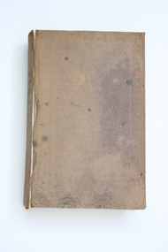
Book, Longman, Brown, Green and Longmans, Physical Description of New South Wales and Van Diemen's Land. Accompanied by a geological map, sections, and diagrams, and figures of the organic remains, 1845
Dr. Gwen Wilson, Emeritus historian, gifted this book at ANZCA's first independent Annual Scientific Meeting held in Launceston in 1994. Dr Wilson presented this gift after her speech about the life of William Russ Pugh and his significant contribution to anaesthesia in Australia. It is unclear as to how the book came into Dr Wilson's possession. Published in London, 1845, for Longman, Brown, Green and Longmans, this book was formally owned by general practitioner Dr William Russ Pugh, being the first medical practitioner in Australia to administer ether anaesthetic on 7 June 1847, in Launceston. The author of the book, P E De Strzelecki acknowledges Pugh for his assistance during his stay in Launceston and for allowing him the use of his laboratory for the analysis of the soils and minerals that were subsequently reported in this book (Page 131). Tan coloured cloth book with an embossed circular motif on the centre of the front and back cover. The same embossed motif is repeated four times along the spine of the book. An embossed design of small, four petal flowers borders the edge of the front and back cover. The title of the book 'Strzelecki's New South Wales and Van Diemen's Land' is printed in gold on the spine. The cloth has come unstuck at various places around the spine and a small section is missing from the base of the spine. The cover is worn and has numerous dark stains possibly from mould. The book contains 19 engraved and lithographed plates. This includes a handcoloured octavo folding, geological map, bound as a frontispiece, depicting the NSW coast down to Gippsland and Tasmania, a fold out single colour geological cross section of the Newcastle Coal Basin, 14 plates illustrating shellfish and flora and three tinted lithographs. Single page maps at the back illustrate wind patterns around Australia. [front title page, two black ink stamps that have bled through to the next page] W R.PUGH [front title page, black ink, cursive writing] H Grant \ 5 May 1910 [front title page, pencil, cursive writing, written around Pugh's stamp] Purchased from \ (unrecognizable script) [front title page, previous owner's name was rubbed out and consequently tore the page making the entry unreadable] [Inner back cover, bottom LHS, blue stamp] BOUND BY \ WESTLEYS & \ CLARK \ LONDON [Inner front cover, bottom LHS, black and purple ink] P65 \ 76 \ 78 \ 98 \ 163 \ 164 \ 217strzelecki, van diemen's land, wilson, gwen, pugh, william, launceston, green and longmans -
 Greensborough Historical Society
Document - Folder, Peter Simmenauer, Hobson land, edited by Peter Simmenauer, 2018_07
Robert Hobson purchased 148 acres of land in Crown Portion 17 from the Crown Grantee John Brown in 1877, which was sold to George Knowles Parker and John Howard Aylwin in 1887. A major purchaser of this land east of the Greensborough Road was Mary Baird in 1929. Although Baird died in 1944, sales from her estate continued until 1956. The folder Includes relevant Old Law documents and Certificates of Title, as well as a list of sales of LP11599 allotments.Loose-leaf folder of documents - lists and plansrobert hobson, mary baird, hobson street greensborough -
 Linton and District Historical Society Inc
Certificate of Title, Certificate of Title: Allotment 36, Section 4, Township of Linton
... Title of the land was transferred to James Adolphus Nelson...Title of the land was transferred to James Adolphus Nelson ...Title of the land was transferred to James Adolphus Nelson and Theophilus William Nelson in 1955. James and Theo Nelson had already purchased adjacent allotments 27 - 30 in 1929.Copy of a Certificate of Title for an allotment of land situated between Grantley Street and Springdallah Creek in Linton. Copy comprised of three photostat sheets held together by tape. Most recent holders of the Title recorded as James Adolphus Nelson and Theophilus William Nelson.certificates of title, allotment 36 section 4 township of linton, james adolphus nelson, theophilus william nelson -
 Ringwood and District Historical Society
Document - Subdivision Map, Part of Crown Portion 22 Parish of Ringwood, County of Mornington. Vol 1915 Fol 827 - LP2427
LANDATA Land Victoria 4-sheet plan dated January 2003 - copy of original 1889 subdivision, amended with 1947 amendments by Assistant Registrar of Titles.Sheet 1 includes Main Lilydale Road (later Old Lilydale Road), Wandin Road (later Mount Dandenong Road), and Joseph Street, Ringwood East. Additional Plan markings SP30844, SP32804, LP144251, PS332061, PS305232. Sheet 2 includes Main Lilydale Road (later Old Lilydale Road), Wandin Road (later Mount Dandenong Road), and Dynes Street, Ringwood East. Additional Plan markings LP43708, LP44231, LP124702. Sheet 3 includes Main Lilydale Road (later Old Lilydale Road), Dynes Street, Albert Street (later Wyrunga Street), and Carcoola Road, Ringwood East. Additional Plan markings LP114181, LP114180, LP18261, LP214030, LP67300, PS354509, PS335500. Sheet 4 includes Main Lilydale Road (later Old Lilydale Road), Albert Street (later Wyrunga Street), and Carcoola Road, Ringwood East. Additional Plan markings PS315494, PS319495. -
 Bendigo Historical Society Inc.
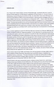
Legal record - FOGGITT JONES & CO. Land sale notes, Watson, James & Rogers, Rogers Collection, 1.7.1913
In the early 1980s the firm of Watson, James & Rogers merged with the partnership of Every & Every and became the iconic “Rogers & Every” as known today. The firm is still located on Bull Street. https://rogersevery.com.au/about/Sale notes to sell land in (Residence Areas), Wade St. Golden Square to Foggitt Jones & Co. Sold all Rights to Titles and Interests. Typed on light brown paper. 1. Joseph Mitchell and Mary Ann Roberts (10317 and 10318) 2. Elizabeth Roberts (10319) 3. Alice Emily Ann Roberts (13126) 4. John Frances Roberts (10363) 5. William Davies Osborne (9805) Release by Mrs Irene Catherine Orrock for Foggitt Jones & Co. handwritten on cream coloured paper.Signatures.land sales, foggitt jones and co. -
 Alfred Hospital Nurses League - Nursing Archive
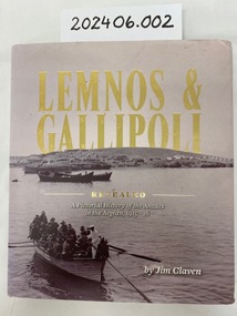
Book - Illustrated book, Jim Claven, Lemnos & Gallipoli revealed : a pictorial history of the ANZACs in the Aegean, 1915-1916
The story of the Hellenic connection to Australia's Gallipoli story. Lemnos was the advance base for the Gallipoli campaign.Hardcover book. Title in gold print. Cover photo, black and white image of first party of officers proceeding from SS Simla to land on Lemnos Island, this is on the dust jacket. Author name printed on front of book and jacket. 352 pages, including over 300 labelled photographs and maps.non-fictionThe story of the Hellenic connection to Australia's Gallipoli story. Lemnos was the advance base for the Gallipoli campaign.wwi, lemnos, gallipoli, ahnl, grace wilson -
 Stawell Historical Society Inc
Photograph, Sister Rocks Title Documents c 1867
Photographs of title documents related to the Sister’s Rocks. c 1867. In 1866 a photographer Mr. O.G. Armstrong feared the Sister's Rock's would be used for building material. Mr. Armstrong and Samuel John Davidson squatter of Great Western leased the ground around the Rock's under the 42nd section of then existing "Land Act" enclosing the rocks with a rough fence. Davidson's lease application was dated 30th Jan 1867. The area applied for was 10 acres and issued 2nd July 1867. The fee paid 2 pound 10 shillings annually till July 1871 when an application to purchase was lodged. Two years later the land was transferred to the Borough of Stawell. Photographs also show maps of the areas. Information also includes 3 typed pages copied from the documents photographs. Documents relating to the Sister Rock's c 1867.documents relating to sister's rock's -
 Eltham District Historical Society Inc
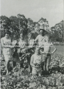
Photograph, Antonio and Angelina Casonato and family
Antonio and Angelina Casonato with their four children and a baby cousin taken with lettuces growing on the river flat at Bell Street, Fabbro Farm (Fabbro Fields) in front of Eltham High School in the late 1960s. The site of the Fabbro farm (Diamond Creek side land) is now made up of Fabbro Fileds and Barrack Bushlands. This title is fairly recent after the Shire of Eltham purchased the land, including the last section in 1993/94. About this time the area on the west side of Falkiner Street was purchased by a private developer and developed as housing. The area in Bell Street opposite the Eltham High School was purchased by the State Government is recent years and is called Fabbro Fields. The Fabbro Family operated their farm in Bell Street, Eltham. 1 black and white photograph reproduction print (low quality)fabbro's farm, bell street, eltham, farming, vegetables, angelina casonato, antonio casonato, fabbro family, fabbro farm, fabbro fields -
 Ringwood and District Historical Society
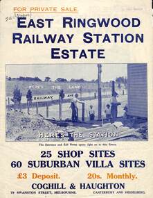
Flyer, Land Sale Brochure, East Ringwood Station Estate - c.1925
... with handwritten sales notations and title ref LP11245. Land Sale Brochure ...Multi-fold double sided sheet with yellow and blue print and blue monotone photographs advertising private sale of retail and residential sites. Brochure includes price list, and details of subdivision features and local facilities, with photographs. Additional clipped map of Estate on cardboard backing with handwritten sales notations and title ref LP11245.Subdivision includes Railway Avenue, Dublin Road, Lawrence Grove, Stanley Avenue. Agents - Coghill & Haughton, 79 Swanston Street, Melbourne, Phone Central 2793. Photographs include construction of East Ringwood Railway Station, "The Dive" where aquatic sports are held, Old East Ringwood Township, Davey's Hill. -
 Kew Historical Society Inc
Biographical information, Ronald Horace Setford (1915–1988)
Ronald Horace Setford was born in April 1915 at 18 Church Street, Hawthorn, at his family’s home above their decorator shop. He was the second of three sons born to Horace Turner Setford (1880-1944) and Mabel Crofts (1887-1943). He attended Hawthorn West Primary School and then Swinburne before beginning work in his family’s business ‘Setford and Son’ in October 1930. This was formalised in April 1931 when he became a carpentry and joinery apprentice. In 1934 he graduated as a grade four carpenter. Ron worked in the family business until 1964 and then worked at J S Kidd and Co Pty Ltd as a storeman until his retirement in December 1973. Ron married Grace Muriel Agnes Perrey (1915-2001) in 1936 and they first lived in Kew around 1940, at 38 Marshall Avenue. Ron served in the Citizen Military Forces as a sapper with the 9 Australian Army Transport Company, Royal Australian Engineers, signing up a week after Darwin had been bombed. He spent time in Darwin, Wayville (South Australia), Herberton and Grovely (Queensland). Afterwards he refused to eat rice, never spoke of the war, nor took part in any ANZAC day proceedings. In 1941, Ron and Grace bought their block of land at 9 Tanner Avenue, East Kew, part of the Old Golf Links Estate, for £225. It was not until December 1945 that Ron started building their home and they moved in during May 1947. Ron and Grace remained there for thirty-seven years until the house was sold to their nephew in 1984. It has since been demolished. Ron’s great passion was photography and in the early 1960s he purchased his Minolta camera. Slide evenings at Tanner Avenue were a regular occurrence. Ron made his own title slides, interval slides and end slides. As well as many holiday photos (around Australia and their world trip in 1966), he enjoyed photographing local landmarks, flowers, insects and family. One of Ron’s photography projects was to record the progress of the building of the Eastern Freeway. This was near their home, and he’d walk down to the works on a regular basis, dressed smartly, with his camera in hand. The workers thought he was an official photographer, and he was allowed on site to take his photos. In 1984, Ron and Grace downsized and moved to Bayswater. Ron passed away on 31 October 1988 at the Maroondah Hospital in Ringwood East, at age 73. His ashes were spread on his beloved rose bushes at Tanner Avenue. Lauren Thomson, 2025ron setford, 9 tanner avenue -- kew east (vic, setford and son -- 18 church st (hawthorn), grace muriel agnes perrey, 9 australian army transport company, j s kidd and co pty ltd, eastern freeway, f19 freeway -
 Bendigo Military Museum
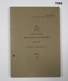
Manual - LAND WARFARE, DRILL, ARMY, HEADQUARTERS TRAINING COMMAND, 3 May 1979
Manual consists of fiteen chapters related to drill movements. 1. Information for the Instructor. 2. Squad drill without arms - at the halt. 3. Marching. 4. Marching in line and changing direction and formation. 5. Rifle exercises at the halt and on the march. 6. Rifle drill for funerals. 7. Pistol drill - 9mm Browning. 8. Sentry Drill. 9. Quarter guards and sentries. 10. Sword Drill. 11. Drill with the cane. 12. Drill with the pace stick. 12. Unit drill - platoon drill. 14. Unit Drill - Company drill. 15. Unit drill - non-ceremonial. Plus list of illustrations, figures and tables. Part of the collection of KEVIN JOHN HERDMAN, No. 397661. See Cat. No. 5942P for details of his service record.Khaki coloured, textured soft covered manual with two punched holes for attaching to a ring binder. Title on front, cover in black type. Army logo in black. Pages are white in colour with black type. Black and white photographs and diagrams. Fifteen chapters. Pages glued to spine.drill movements, australian army, training manual, kevin john herdman -
 Bendigo Military Museum
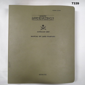
Manual - LAND WARFARE, ARMY, Department of Defence (Army Office), 25 June 1981
Manual contains restricted information covering the following; Part One - Conduct of Operations. Volume 6 - Operational Staff Work. Pamphlet No. 2 - AIDE-DIEMOIRE Part of the collection of KEVIN JOHN HERDMAN, No 397661. See Cat No. 5942P for details of his service recod.Khaki coloured plastic four ring folder. White coloured pages have cut edges. Eash has four holes punched for filing into folder. Title on front in black type. Army logo in black. Text on pages in black type. Black tabs to match chapter. Abbreviated title in black type on spine.australian army, land warfare, manual, kevin john herdman -
 Alfred Hospital Nurses League - Nursing Archive
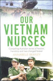
Book - Illustrated book, Annabelle Brayley, Our Vietnam Nurses, 2016
When Australia joined the Vietnam War, civilian nurses were there to save lives and comfort the wounded. Working incredibly long hours and surrounded by chaos and turmoil, these brave nurses and medics were integral to our war effort. These fifteen stories show a side to the Vietnam War that has received little recognition but played an important part in shaping Australia's presence in the war.Illustrated book. Front cover has two coloured photographs: one is of a group of soldiers with three helicopters about to land (members of 5 platoon B Company 7RAR wait for US Army helicopters waiting to take them back to Nui Dat after completion of Operation Ulmarra) The other is of two women wearing green uniforms and peaked caps holding a baby and standing in front of a building with a corrugated roof (RAANC Margaret Ahern and Terrie Roche with children of Hoa Long village) Title (green and black ink) and author's name (light brown ink) are printed between these photos. This information is printed in similar colours on the spine, along with a small photograph of two women in uniform (RAANC Margaret Ahern and Terrie Roche) and the publisher's name. The back cover has a summary of the book printed below five photographs, nurse (Janice Hilton) with patient; nurse (June Minchow) with patient; man (Phil Badcock) and woman (RAANC Di Lawrence); unidentified nurse with four patients strapped to stretchers inside an RAAF Hercules aircraft; two nurses (Von Clinch and Maureen Spicer) with children (at Bien Hoa provincial hospital). non-fictionWhen Australia joined the Vietnam War, civilian nurses were there to save lives and comfort the wounded. Working incredibly long hours and surrounded by chaos and turmoil, these brave nurses and medics were integral to our war effort. These fifteen stories show a side to the Vietnam War that has received little recognition but played an important part in shaping Australia's presence in the war.royal australian army nursing corps, butterwowth air base, military nursing-australia\military nursing-vietnam, vietnam war 1961-1975-medical care, military hospitals-vietnam, military camps-malaysia, military camps-philippines-clark field -
 Kew Historical Society Inc
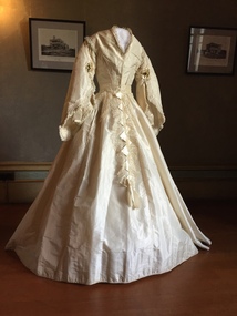
Clothing - White Silk Wedding Dress, c.1869
Joseph Butterworth COOMBS (1842-1901), was an accountant who founded a successful mercantile trading company. At the time of his marriage to Caroline Mary MICHEL in 1869, Coombs had already purchased ten acres of Studley Park. The acreage included land on the west of Fenwick Street that extended along lower Stawell Street to the corner of Yarra Street, all of it connected directly to the Yarra environs. A right of way to Studley Park Road was on the title, though Coombs went on to purchase more land, some of which faced Studley Park Road. In addition to owning the Studley Park acreage, Coombs later acquired 1,201 acres of land abutting the Acheron River. While retaining the Kew property he became a Taggerty Councillor and was Shire President for a time. J.B. Coombs died at Acheron Station in 1901 (aged 59 years). A few months after, tenders were called to repair the Kew dwelling, the Fenwick Street property now appearing in records with the name ‘Hope Mansell’. Caroline Coombs remained at Hope Mansell until she died in 1924, survived by three sons and five daughters. Not long after her death, advertisements appeared for the sale of the Studley Park land. The sale seems to have been a mechanism for distribution of the Estate, as the following year the original ten acre holding was transferred to members of the family. The eldest daughter Mabel married William Younger who, with his brother Alexander, developed Younger and Mackie Courts, both south of Studley Park Road. [Research: Kerry Fairbank]In 1961, the granddaughter of Joseph and Caroline Coombs, Mabel Isola (Younger) Grattan, donated ten 19th century dresses and parasols to the Kew Historical Society. The costumes, now known as the 'Coombs Collection', were the earliest recorded items of clothing to enter the Society's collection. Each of the items in the Coombs Collection, of which this item forms a part, is historically, aesthetically and socially significant. As a collection, the costumes includes outstanding examples of morning wear, day dresses, wedding dresses, and clothing accessories, providing evidence of outstanding dressmaker skills in Victoria during the mid to late Victorian period. Two-piece white silk wedding dress comprised of a short tailored bodice and a bell shaped skirt. The most prominent feature of the bodice is the wide pagoda sleeves, with false undersleeves of muslin. The edge of the sleeves includes small posies of orange blossom. Separate panels of lace, dropping from the waist are the only form of decoration on the skirt. The round high neckline was later converted to v-line in the 19th century.coombs collection, women's clothing, australian fashion, fashion & design collection, costumes, wedding dresses -
 Alfred Hospital Nurses League - Nursing Archive
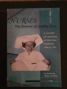
Book - Paperback book, The Box Hill Nursing History Committee, Nurses: the essence of quality care: a history of Nursing at Box Hill Hospital 1956-1991, 2003
A history of Box Hill Hospital, especially nursing aspects, from 1956 to 1991Paperback book with light green/blue cover. Title and authors name in black and white print on front cover and spine. Black and white photo of Jean Argent, midwife at Box Hill hospital 1957 to 1992. Back cover has 6 coloured photos of Box Hill badges for nursing graduates. Numerous black and white illustrations withinnon-fictionA history of Box Hill Hospital, especially nursing aspects, from 1956 to 1991box hill hospital, nursing history -
 Ringwood and District Historical Society
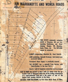
Map, Partially Trimmed Copy of Ringwood Heights Estate, Ringwood, Vic. - circa 1923
Clipped copy of a subdivision advertisement on cardboard backing. Sales notations on numbered allotments in Andersons's Creek Road (later Warrandyte Road) and Wonga Road, Ringwood. Handwritten title reference - LP7305. Captions - This Estate commands extensive views of mountain, hill and dale including Dandenong and Great Dividing Ranges, Mt. Macedon, Keilor Plains, etc. The outlook cannot be surpassed. Climate invigorating, mountain air, good rainfall. Land undulating, splendid drainage; soil, sandy loam on gravel subsoil. Permanent water supply is practically assured. The district has a splendid train service, with electrification in the near future. Electric light & telephone connection can be arranged. Keep in mind this estate is only 1 mile 25 chains from the up-to-date town of Ringwood which has all the trading conveniences of a semi-suburban town and is the centre of one of the largest fruit growing districts in the state. Distance from Melbourne by first class motor road, 16 miles.