Showing 2472 items
matching map of victoria
-
 Marysville & District Historical Society
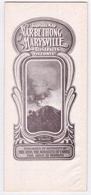
Map (Item) - Tourist Map, Tourists Resorts' Committee, Tourist's Map of Healesville Marysville and Warburton Districts, 13.10.1925
A tourist map for Healesville, Marysville and Warburton that was produced by the Tourists Resorts' Committee. This map was produced in 1925.A tourist map for Healesville, Marysville and Warburton that was produced by the Tourists Resorts' Committee.Photo Lithographed at the Department of Lands and Survey, Melbourne by W.J. Butson./ 13.10.25healesville, marysville, warburton, victoria, tourists resorts' committee, ben cairn, mount donna buang, the black's spur, the acheron valley, narbethong, launching place, tourist information, tourism, map, tourist map -
 Marysville & District Historical Society
Map (Item) - Tourist Map, Department of Lands & Survey, Tourist's Map of Narbethong and Marysville Districts Victoria, 1913
... and Marysville Districts Victoria Map Tourist Map Department of Lands ...A tourist map for the Narbethong and Marysville Districts that was originally produced by the Department of Lands & Survey in 1925.A tourist map for the Narbethong and Marysville Districts that was originally produced by the Department of Lands & Survey in 1925.Reprint of the 1925 Tourist brochure by permission R.E. Holmes Surveyor General By Authority: ALBERT J. MULLETT, Government Printer, Melbourne. Photo Lithographed at the Department of Lands and Survey Melbourne by W.J. Butson/ 26.8.13narbethong, marysville, victoria, department of lands & survey, the acheron valley, warburton, map, tourist map -
 Marysville & District Historical Society
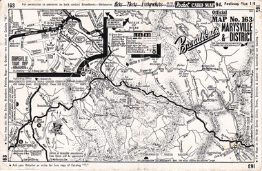
Ephemera (Item) - Pocket card map, Broadbent's Official Road Guides Company, Broadbent's Map No. 163 Marysville & District, 1950s
... publisher of maps. marysville victoria maps broadbent's barton's ...A pocket card map of Marysville and the district. Drawn map of Marysville and the district. Has a legend, scale and a town map of Marysville. Gives an address for Broadbent's Publishing Office of 475 Collins St Melbourne and a Melbourne telephone number - MR 2021. Reverse has advertisements for Barton's Store and Marylands Guest House in Marysville.A pocket card map of Marysville and the district. Gives information about Marysville and the district. Broadbent's was a prolific publisher of maps. marysville, victoria, maps, broadbent's, barton's store, marylands guest house -
 Marysville & District Historical Society
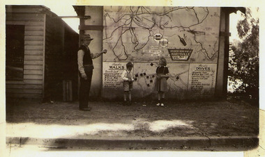
Photograph (Item) - Black and white photograph, 1949
... to an unknown building in Marysville. marysville victoria maps atlantic ...A copy of a black and white photograph of an Atlantic Road Map of Marysville adhered to an unknown building in Marysville.A copy of a black and white photograph of an Atlantic Road Map of Marysville adhered to an unknown building in Marysville.marysville, victoria, maps, atlantic road map -
 Marysville & District Historical Society
Booklet (Item) - Leisure guide, Michael Chesire & Associates Pty. Ltd, MARYSVILLE & DISTRICT LEISURE GUIDE-AUTUMN/WINTER, 1986, 1986
A free leisure guide to Marysville and the surrounding district published for Autumn and Winter, 1986. This was produced by Michael Cheshire as a free publication to promote tourism in Marysville and the surrounding district. It includes maps of the Big River Valley, Cumberland Valley, Lady Talbot Forest Drive, the Marysville area, and the township of Marysville. It was released in the autumn of 1986 and was sponsored by the Marysville Tourist & Progress Association. The Association was formed in November 1907 to promote tourism within the area. This included the physical creation of signage, parklands, roads, and walks to various attractions. A free leisure guide to Marysville and the surrounding district published for Autumn and Winter, 1986.marysville, victoria, australia, leisure guide, michael cheshire & associates pty ltd, marysville golf club, blackwood lodges, sir colin mackenzie fauna park, lake eildon, fraser national park, yarra valley wineries, marysville coach tours, kooringa, marylands guest house, lady talbot forest drive, wishing well, taggerty river recreation area, athols abbey, phantom falls, keppel falls, the beeches walking track, marylyn guest house, kufstein inn motel, the cumberland, marysville tourist & progress association, marysville newsagency & general store, crossways restaurant & motel, beauty spot walk, tree fern gully walk, michaeldene track, keppel track, woods lookout track, marysville hotel motel, lake mountain ski hire, marysville recreation and fun park, mytanta horseback safaris, upper big river valley, the big culvert, marysville mountain view horse hire, maryton park, amber view holiday lodges, cathedral restaurant, the top shop, tower motel, menzes garage, beauty spot nursery, marysville ski hire, lake mountain ski school, faraway forest, scenic motel, buxton trout farm, marysville hardware, timbertop steakhouse, marysville trout farm, healesville sanctuary, buxton hotel motel, nanda binya lodge, buxton antique and furniture mart, the black spur inn hotel, alexandra, lake mountain, geoffrey pope & associates -
 Marysville & District Historical Society
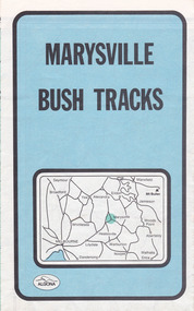
Map (Item) - Bush tracks map, John Siseman et al, MARYSVILLE BUSH TRACKS, 1987
... with information regarding each track. marysville victoria australia map ...A fold out map of the bush tracks in and around Marysville with information regarding each track. This map was published by Pindari Publications and distributed by Algona Publications. The track notes were compiled by John Siseman in 1987. The map was drawn by Glenn van der Knijff.A fold out map of the bush tracks in and around Marysville with information regarding each track.marysville, victoria, australia, map, bush tracks, pindari publications, algona publications, john siseman, gleen van der knijff, lady talbot forest drive, beauty spot walk, michaeldene track, steavenson falls, tree fern gully walk, trestle track, phantom falls, marysville town walk, marysville lookouts round walk, keppel falls, the beeches round walk, cumberland scenic reserve, cambarville, lake mountain, lake mountain walking track -
 Marysville & District Historical Society
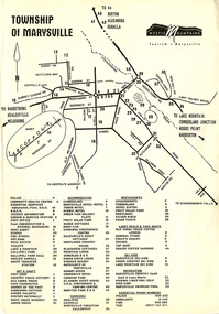
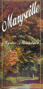
Flyer (Item) - Town map, Mystic Mountains Tourism, TOWNSHIP OF MARYSVILLE, Unknown
... Marysville yarra-valley-and-the-dandenong-ranges A map ...A map of the township of Marysville published by Mystic Mountains Tourism in Marysville. The map shows a legend of various services, accommodation sites, shops restaurants and recreation spots in the township.A map of the township of Marysville published by Mystic Mountains Tourism in Marysville.marysville, victoria, australia, mystic mountains tourism, map -
 Marysville & District Historical Society
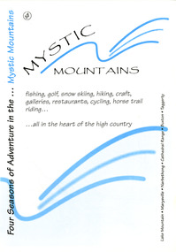
Ephemera (Item) - Visitor information pack, Four Seasons of Adventure in the Mystic Mountains, Unknown
A visitor information pack on Marysville and the surrounding district.A visitor information pack on Marysville and the surrounding district.marysville, victoria, australia, visitor information pack, lake mountain, narbethong, cathedral range, buxton, taggerty, mystic mountains, beauty spot walk, tree fern gully walk, michaeldene track, keppel track, woods lookout track, lady talbot forest drive, wishing well, taggerty river picnic area, taggerty river, phantom falls, keppel falls, the beeches walking track, mount sugarloaf, department of conservation & environment victoria -
 Marysville & District Historical Society
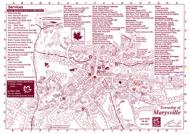
Map (Item) - Information map, Michael Hampton, 2000
... . marysville victoria australia tourist map information map mcnamara ...An information map of the township of Marysville. This map was produced by McNamara Country Real Estate in 2000. The artist who drew the map was named Michael Hampton.An information map of the township of Marysville.MICHAEL HAMPTON/ 2000 VERSION 1:2/ 01/01marysville, victoria, australia, tourist map, information map, mcnamara country real estate, michael hampton -
 Marysville & District Historical Society
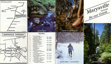
Ephemera (Item) - Tourist Guide, Marysville Tourist Association, Marysville Victoria Be our Guest, Unknown
A fold out tourist guide to Marysville and the surrounding district. This map was produced by the Marysville Tourist Association.A fold out tourist guide to Marysville and the surrounding district.marysville, victoria, australia, tourist guide, steavenson falls, mt cathedral lodge, camelot camel farm, danish coffee garden, marysville country club, crossways country inn, kufstein inn, marysville craft shop, gallery restaurant, the cumberland, tower motel, marysville hotel, scenic motel, fruit salad farm, marylyn guest house, marylands guest house, blackwood lodges, taggerty river, lake mountain -
 Marysville & District Historical Society
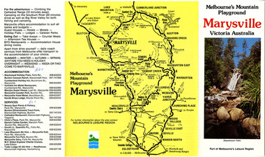
Ephemera (Item) - Tourist Guide, Melbourne's Mountain Playground Marysville Victoria Australia, Unknown
A fold out tourist guide to Marysville and the surrounding district.A fold out tourist guide to Marysville and the surrounding district.marysville, victoria, australia, steavenson falls, marysville golf club, cathedral range, blackwood holiday flats, cumberland holiday inn, kooringa conference and holiday centre, marylyn guest house, marysville caravan park, marysville hotel motel, nanda binya lodge, scenic motel, tower motel, cathedral restaurant, chris's place, danish coffee garden, tudor lodge roadhouse, buxton trout farm, silverstream trout farm, lake mountain ski hire, marysville fun park, mountain view horse hire, jl gould sawmills, marysville dairy, marysville drapery shop, marysville garage, marysville newsagency, top shop -
 Marysville & District Historical Society
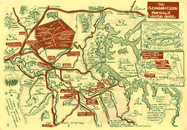
Map (Item) - Tourist map, The Alexandra and Eildon Standard, THE ALEXANDRA & EILDON MARYSVILLE VISITOR GUIDE, 1997
... Marysville yarra-valley-and-the-dandenong-ranges A tourist map ...A tourist map for the Alexandra, Eildon and Marysville region that was produced by the Alexandra and Eildon Standard newspaper. This tourist map was produced in 1997.A tourist map for the Alexandra, Eildon and Marysville region that was produced by the Alexandra and Eildon Standard newspaper.c 1997/ PUBLISHED BY/ THE ALEXANDRA/ AND EILDON/ STANDARD./ GRAPHICS/ BY THE T.T.S./ EILDON.alexandra, eildon, marysville, victoria, australia, tourist map, alexandra & eildon standard -
 Marysville & District Historical Society
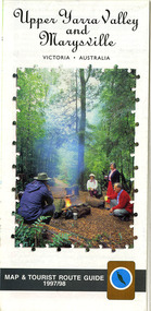
Map (Item) - Tourist map and guide, Warburton Ranges Tourism, Upper Yarra Valley and Marysville VICTORIA-AUSTRALIA, 1997
... in 1997. marysville victoria australia tourist map tourist guide ...A tourist map and guide for the Upper Yarra Valley and Marysville produced by Warburton Ranges Tourism and Mystic Mountains Tourism in 1997.A tourist map and guide for the Upper Yarra Valley and Marysville produced by Warburton Ranges Tourism and Mystic Mountains Tourism in 1997.marysville, victoria, australia, tourist map, tourist guide, mystic mountains tourism, warburton ranges tourism, lake mountain, marysville post shop, the marysville museum, bruno's art and sculpture garden, marylands country house, blackwood cottages, dalrymples guest cottages, anastasia's cottage, marysville hotel motel, kerami guest house, the cumberland -
 Marysville & District Historical Society
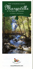
Map (Item) - Map and touring guide, Murrindindi Regional Tourism Association Inc, Marysville & The Mystic Mountains VICTORIA-AUSTRALIA, 08-2002
... Association Inc. marysville victoria australia map and touring guide ...A fold out map and touring guide of Marysville and the surrounding district published in 2002 by Murrindindi Regional Tourism Association Inc.A fold out map and touring guide of Marysville and the surrounding district published in 2002 by Murrindindi Regional Tourism Association Inc.marysville, victoria, australia, map and touring guide, mystic mountains tourism, the beeches rainforest walk, lake mountain, cambarville, cathedral range state park, the cumberland, abbey green b&b cottages, anastasia fairytale cottage, ashlar cottage b&b, somerled mountain retreat, baree mudbrick cottages, blackwood cottages, camellia cottage, cathedral view b&b, cottage riverside, crossways country inn, dalrymples guest cottages, esa country ministries, hillcrest, keppels hotel motel, kerami house, lomatia lodge, lyell guest cottages, marylands country house, marysville caravan park, marysville holiday cottages, maryton park, melina cottage, moondai farm b&b, mountain lodge marysville, mount cathedral lodge, mystic mountains holiday cottages, nanda binya lodge, rendezvous on murchison, scenic b&b, the hermitage, tower motel, waratah house, willowbank at taggerty, woodlands of narbethong, keppels, lake mountain resort cafe, lanterns at willowbank, mantirri blueberry farm, marysville country bakery, the old woolshed cafe, clearstream olives, uncle fred & aunty val's old style lolly shop, acheron valley alpacas country store & gallery, bruno's art and sculpture garden, country touch, things of sand & stone, willowbank gallery, marysville auto & hardware, marysville newsagency & general store, marysville visitor information centre, narbethong visitor information centre, gallipoli park, keppels lookout, lady talbot drive, steavenson falls, steavenson river, taggerty river, acheron river, black spur trail riding centre, buxton trout farm, lake mountain resort ski hire, lake mountain ski school, marysville district country club, marysville ski centre, narbethong ski hire, rubicon horse riding, country touch tours, murrindindi regional tourism association inc -
 Marysville & District Historical Society
Map (Item) - Information brochure, Project Art & Photo, Marysville in the Mystic Mountains, Unknown
An information brochure on Marysville, the surrounding district and the natural attractions in the region published by Mystic Mountains Tourism.An information brochure on Marysville, the surrounding district and the natural attractions in the region published by Mystic Mountains Tourism.marysville, victoria, australia, information brochure, mystic mountains, mystic mountains tourism, cathedral range, lady talbot drive, cameron cascades, phantom falls, keppel falls, beech forest cascades, the beeches rainforest walk, the big tree, cumberland memorial scenic reserve, cambarville, cumberland falls, cora lynn falls, the big culvert, steavenson falls, lake mountain, marysville visitor information centre -
 Marysville & District Historical Society
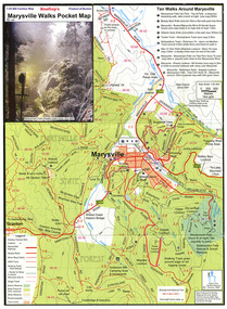
Map (Item) - Pocket map, Rooftop Mapping Services, Rooftop's Marysville Walks Pocket Map, 01-2009
A pocket map of ten walking tracks in an around Marysville. This map was published by Rooftop Mapping Services in January 2009.A pocket map of ten walking tracks in an around Marysville.marysville, victoria, australia, rooftop mapping services, steavenson falls, steavenson falls car park walk, beauty spot walk, marysville to el kanah guest house walk, gilberts gully walk, michaeldene track, man 'o' war walk, tree fern gully walk, marysville to woods lookout to mount gordon walk, keppels lookout walk -
 Marysville & District Historical Society
Map (Item) - Tourist map, Mystic Mountains Tourism, OFFICIAL VISITORS' MAP MARYSVILLE LAKE MOUNTAIN, Unknown
... for Visit Victoria. A visitors' map of Marysville and Lake Mountain ...A visitors' map of Marysville and Lake Mountain produced by Mystic Mountains Tourism for Visit Victoria.A visitors' map of Marysville and Lake Mountain produced by Mystic Mountains Tourism for Visit Victoria.The Marysville and Lake Mountain Visitor Map and Touring Guide has been compiled and/ published by Mystic Mountains Tourism Inc. Copyright./ Production and artwork Graph Attack P/Lmarysville, lake mountain, victoria, australia, visitor's map, official visitors' map marysville lake mountain, buxton, narbethong, taggerty, visit victoria, mystic mountains tourism inc, graph attack p/l, mystic mountains, marysville triangle, marysville visitor information centre, marylands country house, black spur, steavenson falls, lady talbot drive, cambarville, cathedral ranges, wirreanda festival, lake mountain summit walk, summit walk loop, leadbeaters loop, day loop walk, buxton hotel, igloo roadhouse, karmann waters, silverstream b&b cottages, buxton trout and salmon farm, the niche wine bar, buxton post office & general store, choppers buxton roadhouse, woodlands rainforest bungalows, chestnut glade, black spur inn, wombat cottage, abbey lake luxury b&b spa cottages, mystic mountain ski hire & outdoors, pnl 4wdriving, blue views holiday units & ski hire, marapana agistment park & farm stay b&b, danico design, things of sand & stone, mantirri blueberry farm, allawah country cottages, amberview cottages, ashlar cottage b&b, black spur motel & caravan park, blackwood deluxe cottages, blackwood courtyard b&b, dalrymples guest cottages, delderfield, el kanah guest house, fruit salad farm, kerami guest house, keppels hotel, lake mountain-snow gum lodge, lomatia lodge, lyell guest cottages, magnolia house, keppel waters, lyrebird apartments, marysville caravan park, all view spa apartments, riverside cottages, maryton park b&b country cottages, melina cottage, mountain lodge, mystic mountains holiday cottages, nanda binya lodge, rendezvous luxury cottages, scenic b&b motel, the cumberland, south cathedral farm, tower motel, willowbank at taggerty, woodlands rainforest retreat, marysville & district country club inc, mystic mountains ski hire & outdoors, rubicon valley horse riding, marysville trout and salmon ponds, gallipoli park, keppels lookout, cambarville-yarra ranges national park, lake mountain-yarra ranges national park, lady talbot drive-yarra ranges national park, cathedral range state park, steavenson river, taggerty river, acheron river, lake mountain alpine resort, bruno's art and sculpture garden, manical mechanicals, uncle fred & aunty val's old style lolly shop, carmyle farm boutique, crossways historic country inn, fraga's, gilberts restaurant, heights licensed bistro, the old woolshed cafe, cathedral view natural therapies, crystal journey -
 Marysville & District Historical Society
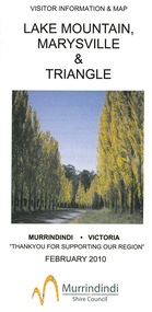
Map (Item) - Tourist map, Murrindindi Shire Council, VISITOR INFORMATION & MAP LAKE MOUNTAIN, MARYSVILLE & TRIANGLE, 02-2010
... mountain marysville victoria australia visitor information & map ...A visitor information map for Lake Mountain, Marysville and the local district produced by the Murrindindi Shire Council in February 2010. This information guide and map was produced after the 2009 Black Saturday bushfires destroyed most of the township of Marysville.A visitor information map for Lake Mountain, Marysville and the local district produced by the Murrindindi Shire Council in February 2010.Murrindindi Shire Council has made every effort to ensure the information provided at the time/ of printing is correct, but accepts no responsibility for an inaccuracies or omissions.lake mountain, marysville, victoria, australia, visitor information & map, murrindindi shire council, big 4 holiday park taggerty, black spur inn, black spur motel & caravan park, bush creek buddha, buxton hotel motel, cathedral valley farm, chestnut glade, crossways historic country inn, delderfield luxury b&b, kingbilli country estate, marapana agistment park & farm stay b&b, maryton park b&b, pinjarra gardens, sarsens rest, silverstream b&b, tower motel, willowbank at taggerty, wombat cottage, woodlands rainforest retreat, buxton general store and post office, buxton zoo nursery, cathedral view natural therapies, country touch, cross country ski hire, foodworks, highwood health retreat, lake mountain ski hire, lit & beyond, lj hooker, maroondah outdoor equipment/bait & tackle, marysville medical centre, marysville patisserie, marysville ski centre, marysville triangle real estate, marysville visitor information centre, mystic mountains ski hire/outdoors, pat's hairdressing, penni lanes country wares, plant's by shelian -
 Marysville & District Historical Society
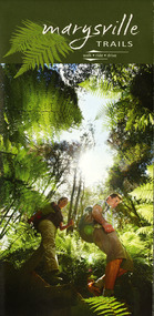
Map (Item) - Walking map, Department of Sustainability and Environment, marysville TRAILS, 07-2011
A map showing all the walking trails in and around Marysville and the district. This map was produced by the Department of Sustainability and Environment in July 2011.A map showing all the walking trails in and around Marysville and the district.ISBN 978-1-74287-122-6 (print)marysville, victoria, australia, marysville trails, department of sustainability and environment, parks victoria, steavenson falls trail, beauty spot trail, gilberts gully trail, tree fern gully trail, michaeldene trail, wilks creek trail, keppel lookout trail, lady talbot drive, taggerty cascades, the beeches, keppel falls, phantom falls, cathedral range state park, cambarville, lake mountain trails, cumberland falls, mystic mountains tourism -
 Marysville & District Historical Society
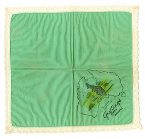
Souvenir (Item) - Souvenir handkerchief, Unknown
A souvenir handkerchief from The Log Cabin in Marysville in Victoria.A souvenir handkerchief from The Log Cabin in Marysville in Victoria. The Log Cabin was built by Thomas Henry Branchflower who had arrived from England late in 1921. It was built for Gwendoline Pitman after the death of her father Clarence Pitman and the disappearance of her sister Olive in July 1926. Gwendoline operated an artist and souvenir shop in the newly built Log Cabin in partnership with Peter Mackey who was a Melbourne optician and artist.SOUVENIR/ OF AUSTRALIA Greetings/ from/ Marysville.the log cabin, marysville, victoria, thomas henry branchflower, gerald branchflower, mary chain, gwendoline pitman, clarence pitman, kooringa guesthouse, olive pitman, wilbur anderson, peter mackey, souvenir handkerchief, souvenir -
 Marysville & District Historical Society
Flyer (item) - Information Flyer, Forests Commission, Victoria, Cumberland Scenic Reserve, 1918-1983
An information flyer that was produced as a guide to the Cumberland Scenic Reserve by the Forests Commission of Victoria. The Forests Commission Victoria (FCV) was the main government authority responsible for management and protection of State forests in Victoria, Australia between 1918 and 1983. The Commission was responsible for ″forest policy, prevention and suppression of bushfires, issuing leases and licences, planting and thinning of forests, the development of plantations, reforestation, nurseries, forestry education, the development of commercial timber harvesting and marketing of produce, building and maintaining forest roads, provision of recreation facilities, protection of water, soils and wildlife, forest research and making recommendations on the acquisition or alienation of land for forest purposes″. The Cumberland Scenic Reserve is set in the heart of the mountain forests of Victoria and is 16km east of Marysville on the Cumberland Road. This reserve forms part of the catchment of Armstrong Creek, a tributary of the Yarra River which provides water for the Melbourne area. The reserve is a prime mountain ash area in which is set the old Cambarville sawmill and village site.An information flyer that was produced as a guide to the Cumberland Scenic Reserve by the Forests Commission of Victoria. 423Aforests commission victoria, cumberland scenic reserve, marysville, victoria, cambarville, the big tree, cora-lyn falls, barton's lookout, cumberland falls, sovereign view, armstrong creek, yarra river, mountain ash -
 Gippsland Vehicle Collection
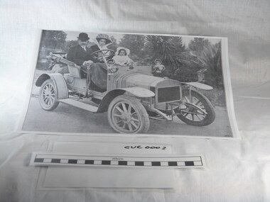
Book, Darge, Victoria's Leaders in the Motor Car World, 1911 (estimated); Based on make & models of vehicles, maps, and articles
Book of "Darge" photographs c.1911. Algenon Darge was a noted photographer in Melbourne around the commencement of the 20th century. 124 pages"The property of Bramwell" "thanks Fred" "Fred Armylope\19/7/68"melbourne, melba, dame nellie melba, gippsland, cars, darge, broadbent, road map, advertisements, touring, james flood, hudson, berliet -
 Eltham District Historical Society Inc
Book, Roger Franklin, Inferno: The Day Victoria Burned by Roger Franklin, 2009
Description of bush fires in Victoria on Black Saturday 7 February 2009267 p., [16] p. of plates : ill. (chiefly col.), maps, ports. ; 25 cm.ISBN black saturday, bush fires victoria -
 Glen Eira Historical Society
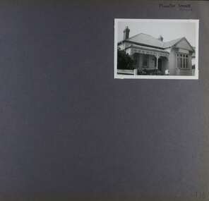
Album - Album page, Munster Avenue, Circa 1972
This photograph is part of the Caulfield Historical Album 1972. This album was created in approximately 1972 as part of a project by the Caulfield Historical Society to assist in identifying buildings worthy of preservation. The album is related to a Survey the Caulfield Historical Society developed in collaboration with the National Trust of Australia (Victoria) and Caulfield City Council to identify historic buildings within the City of Caulfield that warranted the protection of a National Trust Classification. Principal photographer thought to be Trevor Hart, member of Caulfield Historical Society. Most photographs were taken between 1966-1972 with a small number of photographs being older and from unknown sources. All photographs are black and white except where stated, with 386 photographs over 198 pages. This house continues to occupy the property at 5 Munster Avenue Carnegie (Google map image capture Feb 2019).Page 136 of Photograph Album with one landscape photograph of an Edwardian house on Munster Avenue.Handwritten: Munster Street / Avenue [top right] / 136 [bottom right]trevor hart, garden, verandah, bull nosed verandah, edwardian, coloured glass, corrugated iron roof, bay window, gable, chimneys, porch, munster avenue, carnegie, box bay window, weatherboards, cast iron work, timber houses -
 Glen Eira Historical Society
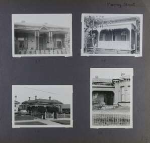
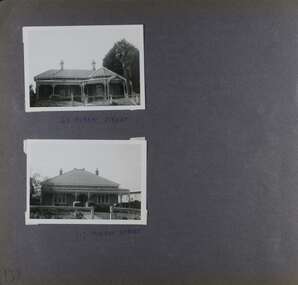
Album - Album page, Murray Street, Circa 1972
This photograph is part of the Caulfield Historical Album 1972. This album was created in approximately 1972 as part of a project by the Caulfield Historical Society to assist in identifying buildings worthy of preservation. The album is related to a Survey the Caulfield Historical Society developed in collaboration with the National Trust of Australia (Victoria) and Caulfield City Council to identify historic buildings within the City of Caulfield that warranted the protection of a National Trust Classification. Principal photographer thought to be Trevor Hart, member of Caulfield Historical Society. Most photographs were taken between 1966-1972 with a small number of photographs being older and from unknown sources. All photographs are black and white except where stated, with 386 photographs over 198 pages. Houses shown at 35, 58 and 32 Murray Street Elsternwick are still all extant (Google map image capture Dec 2018). Victorian Heritage Database - HO130 32 Murray Street Caulfield https://vhd.heritagecouncil.vic.gov.au/places/35535 (at 14/08/2021) No. 32 Murray Street is locally distinguished as the most imposing villa of its period in Murray Street whilst its association with J. W. Doyles, builder of several houses in the same street, is of interest. Its importance is enhanced by its substantially intact state.Page 138 of Photograph Album with four photographs (three landscape, one portrait) of 3 different houses on Murray Street. Handwritten: Murray Street [top right] / 35 [under top left photo] / 58 [under top right photo] / 32 [under bottom left photo] / 32 [under bottom right photo] / 138 [bottom right]trevor hart, garden, verandah, murray street, elsternwick, victorian style, houses, cast iron work, bay windows -
 Glen Eira Historical Society
Album - Album page, Murray Street, Circa 1972
This photograph is part of the Caulfield Historical Album 1972. This album was created in approximately 1972 as part of a project by the Caulfield Historical Society to assist in identifying buildings worthy of preservation. The album is related to a Survey the Caulfield Historical Society developed in collaboration with the National Trust of Australia (Victoria) and Caulfield City Council to identify historic buildings within the City of Caulfield that warranted the protection of a National Trust Classification. Principal photographer thought to be Trevor Hart, member of Caulfield Historical Society. Most photographs were taken between 1966-1972 with a small number of photographs being older and from unknown sources. All photographs are black and white except where stated, with 386 photographs over 198 pages. 63 and 117 Murray Street houses are extant (Google maps image capture Dec 2018).Victorian Heritage Database - HO131 63 Murray Street Caulfield https://vhd.heritagecouncil.vic.gov.au/places/35569 (as of 14/08/2021) "Marston" at no. 63 Murray Street, Caulfield South, was built by J.E. Guest, a contractor resident in nearby Downshire Road, in 1889-90, presumably as a speculative venture together with the extant house at adjoining No.61. It is aesthetically significant. It is aesthetically significant (Criterion E) as an exceptionally richly ornamented medium sized Boom period villa in Caulfield South, being unusual in this respect in its locale and comparing with nearby "Sprouston" at 19 Blanche Street (1887). Important contributory elements include the polychrome brickwork, frieze and verandah including the half timbered gablet which would have been stylistically innovative in its day.Page 139 of Photograph Album with two landscape photographs of two different houses in Murray Street. Handwritten: 63 MURRAY STREET [under top photo] / 117 MURRAY STREET [under bottom photo] / 139 [bottom left]trevor hart, garden, verandah, murray street, elsternwick, victorian style, houses, marston, house names, j e guest, verandahs, polychrome bricks, cast iron work, chimneys -
 Glen Eira Historical Society
Document - HOWITT FAMILY
Four documents on the history of the Howitt family: 1/A photocopied extract on Dr. Godfrey Howitt, taken from biographical information in ‘A Woman of Importance’, by Jean Uhl. Information details his family history, religion, his medical affiliations, his garden in Collins St. 2/Two page print out from Wikipedia done 13/12/2013 on Godfrey Howitt giving family history and his medical history in Melbourne; includes a sketch of him. 3/Family tree map by Claire Barton. 4/Print out on Alfred William Howitt, taken from Monash website, on his life as an explorer, geologist and anthropologist. Monash University’s Howitt Hall is named in his honour.howitt godfrey dr., howitt mrs., bakewell miss, howitt william, bakewell phoebe, caulfield, howitt alfred william, melbourne hospital, benevolent asylum, howitt william godfrey, farms, entomologist, howitt john henry, howitt charles, medical school committee, university of melbourne, philosophical society of victoria, royal society of victoria, magistrate, howitt hall, explorer, geologist, anthropologist, ‘howittia’ blue-flowered mallow -
Glen Eira Historical Society
Article - OUTER CIRCLE RAILWAY
This file contains five items: 1/Two copies of a document titled THE OUTER CIRCLE RAILWAY by the Royal Historical Society of Victoria and the Australian Railway Historical Society, Vic div. It details the history of the construction of the Outer Circle Railway and discussed expenses and other factors affecting the construction of the line. Notes compiled by R.K Whitehead, Research and Archives Officer Australian Railway Historical Society Victoria Division. The document includes three maps of the outer circle railway line. 2/Four newspaper articles detailing the history of the Outer Circle Railway Line. They include ten black and white images of various aspects of the railway and three line maps. The first article is titled ‘Rail Link with the Past’. In the COLLINGWOOD COURIER dated 07/10/1970, author unknown. The second article titled ‘Ghost trains of the Outer’ by Kenneth Joachim in the HERALD dated 18/04/1975. The third article is titled ‘Tracks in Time’ by Norman Thompson from NEWS, dated 13/02/1973. The fourth article is titled ‘Our Ghost Railway’ by John Townsley from the HERALD, dated 06/11/1974. 3/A letter from Victorian Railways Chief Estate Officer N.A Wigmore to the Honorary Secretary of the Caulfield Historical Society, dated 19/11/1975 regarding the leasing of land along the Outer Circle Railway Reserve from Dandenong Road to the Hughesdale Station. 4/Two copies of an article titled ‘Outer Circle Railway’ in the CAULFIELD HISTORICAL SOCIETY NEWSLETTER undated detailing the history of the outer circle line. The article includes a map of the section of the line in Caulfield. 5/A Photocopy of two images of train line locations on the Outer Circle Line. One on Warrigal Road, looking south from Ashburton dated 1936. The second is of the Black Bridge over Gardiners Creek dated 1935.outer circle railway, normanby road, caulfield station, outer circle line, rosstown junction railway, monash john, caulfield historical society, poath road, deepdene dasher, ashby dasher, dandenong road, gippsy goods, mallee root mercury, outer circle railway reserve, railway lines, railway stations, steam trains -
 Glen Eira Historical Society
Document - PRAHRAN AND MALVERN TRAMWAYS TRUST
This file has 3 items. 1/Photocopy of Caulfield Conservation Study Report by Andrew Ward dated January 1995 of 6-8 Rusden Street, Elsternwick being former Prahran and Malvern Tramways Trust substation. Report includes image, existing registrations, description of substation building and condition. 2/Original photograph (black and white) of tram shelter at corner of Balaclava Road and Orrong Road, Caulfield North, outside Grimwade House (school), description written on back of photo. 3/Original copy of magazine of the Tramway Museum Society of Victoria Ltd. ‘Running Journal’ Vol 7 No. 3 dated June 1970. Article (pages 3-7) entitled ‘Feeding & Filling, The Story of the Prahran & Malvern Tramways Trust’ written by Graeme Breydon. Article written for the 60th anniversary of the trust which opened for business on 30/05/1910 and describes the establishment and development of Tramways between suburbs of Malvern & Prahran including Elsternwick, Caulfield & Glen Huntly. Article includes 4 images plus map and diagram. Included: Photograph 3: Opening ceremony of tramway extension from Balaclava junction to Elsternwick railway station on Glen Huntly Road dated 13/11/1913. Diagram of various tramway routes including Prahran & Malvern Tramways Trust routes.prahran and malvern tramways trust, p+mtt, tram companies, land transport, public transport, substation, tram shelter, powerhouse, parapet, brick, stuccoed, roof lanterns, historic buildings register, national estate register, national trust register, rusden street, balaclava road, orrong road, hawthorn road, dandenong road, glen huntly road, grange road, elsternwick, elsternwick railway station, caulfield, caulfield north, caulfield railway station, point ormond, grimwade house, breydon graeme, tramcar, edwardian, transport, trams, tram depot -
Glen Eira Historical Society
Document - GLEN HUNTLY
This file contains 3 items about land subdivision and development in Glen Huntly: 1/1 colour real estate advertisement (undated) for the auction of lots of land in Glen Huntly Park Estate, Glen Huntly to be held 06/12/1930. The poster includes1 black and white photograph (85mm x 201mm) of the Shopping Centre on Glen Huntly Road and a colour map (95mm x 107mm) of the Estate and surrounding locality. Also included on the poster is 1 black and white photograph of the Glen Huntly Park Estate and Cypress Plantation of the Glen Huntly Park. 2/1 undated advertisement for an auction of land in Glen Huntly Park to be held 19/03/1938 pursuant to an order to an order for sale made by the Supreme Court of Victoria. It includes 1 black and white photograph (52mm x 375mm) of shops along Koornang Road and 1 black and white photograph (52mm x 375mm) of shops along Glen Huntly Road. 3/1 black and white aerial photograph (undated and unattributed) (164mm x 272mm) of Glen Huntly Park Estate and surrounding area, with street names added, which indicates the second section of the Estate for sale.glen huntly, grange road, glen huntly road, watson crescent, garden avenue, wattle avenue, park avenue, mckay avenue, neville street, miller street, morgan street, truganini road, koornang road, glen huntly park and recreation reserve, glen huntly park estate, royal avenue, glen huntly railway station, tram depots, lyons street, moira avenue, katandra road, ormond, mimosa road, glen huntly park pty ltd, city of caulfield, lord h, land sales, auctions, parks and reserves, shops, elsternwick, caulfield