Showing 761 items
matching middle east
-
 St Kilda Historical Society
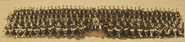
Postcard, Artillary East St Kilda 1938/9
Middle back row is J R Hallsepia photograph -
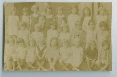
 The Foundling Archive
Postcard- West Sydney
This photograph is part of the West Sydney Collection which depicts the period around Second World War in Australia from the perspective of a young unknown woman.Photograph postcardMiddle row, 4th from left school photo; postcard; west sydney; australia; suburbia; grade 3 -
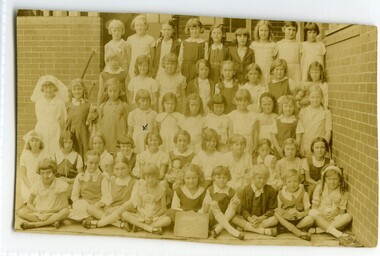
 The Foundling Archive
Photographic postcard- W.Sydney
This photograph is part of the West Sydney Collection which depicts the period around Second World War in Australia from the perspective of a young unknown woman.me middle row, third from left 1931kindergarten; west sydney; australia; suburbia; 1930's; children -
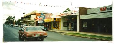 Tatura Irrigation & Wartime Camps Museum
Photograph, Westpac, Hogan Street, Tatura
Shows picture of businesses looking east down Hogan street towards the Clock Tower intersection, Hogan Street, Tatura. Colour photograph showing businesses looking east down Hogan Street towards where the Clock Tower is located in Hogan Street, Tatura. Photograph stuck onto piece of white cardboard. hogan street tatura, criterion hotel tatura, westpac tatura, chemmart tatura, maskell real estate tatura, middle cafe tatura -
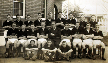 Williamstown High School
1947 Junior Football Team
Sepia photograph, original. We also have a 200 mm x 152 mm enlargement.1947 Junior Football Team. Back row: B. Bricoe, R. Miller, A. Copeland, D. Henderson, D. Valentine, N. Trevan, R Wiffin, N. David, B. Thomas Middle row: C. West, G. East, N. O'Connor, F. Bron (C), Mr Walsh (Coach), J. Murray (V.C.), L. Govan, F. Brane, W. Gibson Front row: J. Whise, D. Rowan, A. Macerywilliamstown high school, 1947, football -
 Uniting Church Archives - Synod of Victoria
Clothing - Regalia - gaiters, Presbyterian Moderator
The gaiters, buttoned up the side, cover the leg from the ankle to a point just below the knee. This was appropriate in the time when clergy's travelling would be on horseback but continued into the middle of the 20th century.Pair of black wool with tape binding and 11 fabric covered buttons. They have fabric instep strap and are boned. The gaiters have button holes at the top to attach to britches.presbyterian moderator -
 Uniting Church Archives - Synod of Victoria
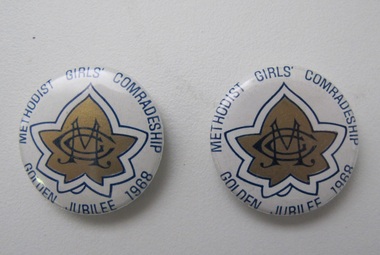
Badge, Methodist Girls' Comradeship
MGC 063.1 and MGC 063.2 Blue, white and gold round Methodist Girls' Comradeship badges with the MGC badge in the middle and text around the border. "MGC" "METHODIST GIRLS' COMRADESHIP GOLDEN JUBILEE 1936"methodist girls' comradeship, methodist girls' comradeship golden jubilee 1968, badges -
 Uniting Church Archives - Synod of Victoria
Card, The Vigil
Each MOK Court was required to display this image and their Charter at their meetings. The original painting by John Pettie depicts a squire holding a vigil of prayer during the night before his knighting ceremony. This was a custom during the Middle Ages. The Methodist Order of Knights was the official youth organisation of the Methodist Church of Australasia. It originated in Hurstville, NSW, on the 4th October 1914 by the then Mr and later Rev Alex Bray. Alex Bray was a Sunday School teacher and spoke to his class of the Knights of the Round Table. In 1917 the Order of Knights was officially recognised by the Sunday School Dept of the NSW Methodist Conference. Courts spread thoroughout Australia. In 1927 the High Court of NSW called for designs for a badge and in 1929 the General Conference of the Methodist Church of Australasia recognised the Order as an approved Organisation. In 1938 the Senior Section was organised into Degrees of Sincerity, Service and Sacrifice; the Junior Section into Pages' Degree with advancement to Esquire. In 1954 the Junior Section was reorganised into two groups: Pages 8 to 11 years and Esquires 12 to 15 years. The Knight's Motto: "Live Pure, Speak True, Right Wrong, Follow Christ the King, else wherefore born?" Courts of the Order: General Conference Department of the Christian Education - General Court - Provincial High Court - District Court - Local Court - Senior Court - Intermediate Court - Junior Court . Regalia: All members of the Intermediate and Senior Courts wore regalia consisting of a cloth shield superimposed by a cross of light and dark blue ribbons, and supported by a cloth collar. Esquire and Degree of Sincerity regalia: White collar and white shield. Degree of Service regalia: Green collar and shield. Degree of Sacrifice: Scarlet collar and shield. District Court regalia: Blue collar and gold shield. High Court regalia: Gold collar and purple sheild. General Court regalia: Purple collar and shield. Officers of the local courts wore their symbols as part of their regalia. E3112.15.1 and E3112.15.2: Black and white modified image of the painting "A Knight's Vigil" by John Pettie, R.A. 1839-1893.THE VIGILmethodist order of knights -
 Uniting Church Archives - Synod of Victoria
Furniture - Communion rail
Communion set used in The Wesleyan Jubilee Church Toorak Church which was built in 1877. The church was illegally demolished by developers in 1985.Dark timber and brass communion rail. The rail has timber top and bottom rails together with corner and middle supports. It has a brass finish and vine motif. the wesleyan jubilee church toorak -
 Uniting Church Archives - Synod of Victoria
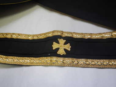
Uniform - Regalia - Stole, Probably early 1970s
The Stole is a Methodist Minister's stole or perhaps the President's stole.Black fabric sole with gold fringing at each end. The edges are decorated with gold brocade style ribbon. The stole has symbols at each end and a small cross at the middle. The stole is made of synthetic materials."METHODIST CHURCH OF AUSTRALASIA THE BEST OF ALL IN GOD WITH US"methodist church of australasia, regalia -
 Uniting Church Archives - Synod of Victoria
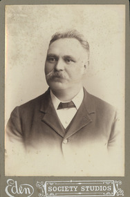
Photograph, C. H. Holmes, C. late 19th/early 20th century
None other than the inscription.Head and shoulders portrait of a middle-aged man with moustache."Mr C. H. Holmes, Secretary of the Trust and connected with Denham Street from the beginning."holmes, c. h., denham street hawthorn methodist church -
 Uniting Church Archives - Synod of Victoria
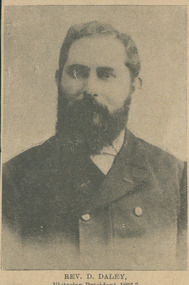
Newspaper cutting, Rev. Daniel Daley, 1896-7
Born 1863 Victoria, ordained 1884, died 1939 Brighton Victoria. Victorian President of the Conference, 1896–97.Aged newspaper clipping photo of the head and shoulders of a late middle-aged heavily bearded man wearing a double-breasted suit.daley, daniel, conference president victoria 1896–7 -
 Uniting Church Archives - Synod of Victoria
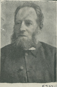
Photograph, Rev. George Daniel, Late 19th C
B. 1823 England; d. ordained 1846; d. 1896 St Kilda Victoria.Portrait photo showing a middle-aged man with an Abraham Lincoln beard, dressed in a clerical collar and dark suit coat."Rev. Geo. Daniel"daniel, george -
 Uniting Church Archives - Synod of Victoria
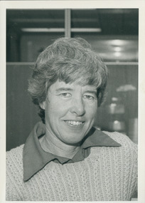
Photograph, Carmyl Winkler article: "Sparrows and lions", 1984
Carmyl was a contributor to C&N and her article was under the heading "Prayer". This article had 6 sections relating to prayer.Middle-aged woman's portrait.C&N identification.winkler, carmyl, c&n 11/071984 -
 Uniting Church Archives - Synod of Victoria
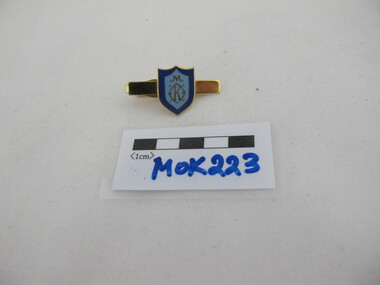
Tiepin
The tie pin was part of the MOK dress uniform and was worn in the middle of the plain dark blue tie.Gilt and enamelled MOK tie pin. The shield shaped MOK symbol is dark and light blue enamel."MOK"methodist order of knights -
 Uniting Church Archives - Synod of Victoria
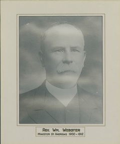
Photograph, Undated c.1900
William Webster was born in England in 1848. He was ordained into the Presbyterian ministry in Melbourne for Middle Darling-Wilcannia, N.S.W. in 1880. He served in Inglewood Vic. from 1884; Kerang from 1889; St. Andrew's Oakleigh from 1900. Was demitted in 1912 and died in 1919.B & W head and shoulders enlargement of F36: a studio portrait of the Rev. William Webster, mounted on cream card. The photograph has a grey card mount with an inscription.REV. WM. WEBSTER MINISTER ST. ANDREWS 1900 - 1912"rev william webster presbyterian minister, st andrew's presbyterian church oakleigh -
 Uniting Church Archives - Synod of Victoria
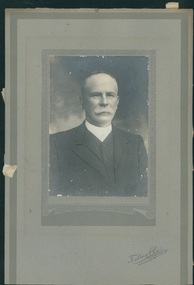
Photograph, Talma & Co, C. 1900
William Webster was born in England in 1848. He was ordained into the Presbyterian ministry in Melbourne for Middle Darling-Wilcannia, N.S.W. in 1880. He served in Inglewood Vic. from 1884; Kerang from 1889; St. Andrew's Oakleigh from 1900-1912. He was demitted in 1912 and died in 1919.Matte, sepia toned head and shoulders studio portrait of Rev. William Webster. The photograph is mounted on a textured and patterned grey card which bears the photographer's details. The Rev Webster is looking directly at the camera and is wearing his clerical clothes.On the front "Talma & Co. 119 SWANSTON ST. MELBOURNE."rev william webster presbyterian minister, st andrew's presbyterian church oakleigh -
 Uniting Church Archives - Synod of Victoria
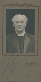
Photograph, Rev. Samuel J. Hoban, 1920s?
B: 1864 Victoria; D: 1931 Melbourne. Ordained 1891 (see B78). See also L320 p. 60; F665 (3 photos); F768 (portrait from Benalla history).Black and white photograph on brown card backing of Rev. Samuel J. Hoban dressed in suit and clerical waistcoat and collar. White hair, parted in the middle.With kindest thoughts, Samuel J. Hobanhoban, samuel j., b78 ordinands 1891, benalla 1894-1897, wesley church (undated), see also l320 p. 60; f665 (3 photos); f768 portrait in extract from benalla history. -
 Uniting Church Archives - Synod of Victoria
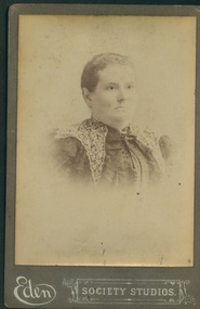
Photograph, Late 19th, early 20th century - undated
Head and shoulders, sepia, woman of middle age, short hair cropped close to head, wearing dress with shoulder overlay lace. Photo stuck on brown backing card with photographic studio's name."Mrs Breseford" scrawled on back, although the spelling of the name is not clear.breseford, eden society studios -
 Uniting Church Archives - Synod of Victoria
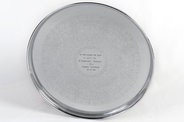
Communion tray, c1959
Round stainless steel communion tray with pattern and engraved wording in the middle."TO THE GLORY OF GOD A GIFT TO ST ANDREW'S ARARAT FROM CAROL GEORGE 14/11/59"st andrews presbyterian church ararat, george, carol -
 Uniting Church Archives - Synod of Victoria
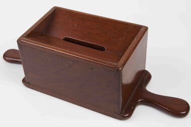
Poor fund box
Varnished wood collection box with dove tail joints. The top is sloping towards the middle and has a slot for offerings. The box is opened by sliding one piece of the top off.offering box -
 Hume City Civic Collection
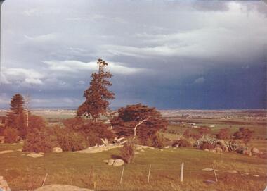
Photograph, September 1994
Woodlands Park complex which includes 'Cumberland' and 'Dundonald' ruins and the Gellibrand Hill Quarries was acquired by the Victorian State Government in 1978 and is managed by Parks Victoria.A view taken from Gellibrand Hill looking east towards the developing suburb of Greenvale. There are small rocky outcrops in the foreground and a clump of conifers and cypress trees in the middle. The sky is very overcast and a range of mountains can be seen across the skyline. Coloured photograph with rounded corners and matt finish.woodlands park, gellibrand hill, greene, william pomeroy, anne, george evans collection -
 Stawell Historical Society Inc
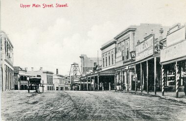
Photograph, Upper Main Street Stawell looking East with on left the 2 story Allingham building & behind the cart is the Commercial Hotel c1910
Upper Main Street Stawell. Looking East c1910. On left two story Allingham building behind cart is Commercial Hotel. Oriental Bank. Punchard Furniture. Crown Cross Poppet head visible on Big Hill. The side of the Mechanics Institute visible near centre. H S Dawson Chemist. Clarke & Scott Drapery on right. Same as 6730-1 & 1423Streetscape of upper main street looking east, Crown Cross poppet head at end of street in middle of streetUpper Main Street Stawell.mining, streetscape, businesses -
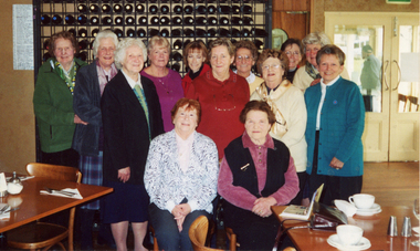 Ballarat Base Hospital Trained Nurses League
Mary Lamb Birthday Party - at Gilberts on Lake, many past trainees
Back L-R: Kath Moran, Mary Morcom, Jill Watkins, Tracey Cummins, Gwen Bennett, Linda Cummins, Winsome Menadue Middle: Alma Egan, Alison Sherritt, ??, June East Seated: Roma ? & Mary LambHard Copymary lamb, birthday, menadue -
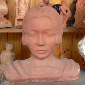 Duldig Studio museum + sculpture garden
Sculpture, Slawa Horowitz-Duldig, Self-portrait by Slawa Horowitz-Duldig c. 1924, c.1924
This self-portrait exemplifies Karl and Slawa's shared interest in the art forms of other cultures - also seen in the significant number of Viennese art books on these topics in the Duldig Studio library. It takes inspiration from Egyptian sculptures and is strikingly similar to the cover image of Götter Ӓgyptens (Gods of Egypt) by Alexander Scharff (Library) although her short hair puts a stylish and very modern slant upon the image. The sculpture is hollow, with a large opening at the rear. Slawa on full face, eyes downcast, hair parted in the middle & pulled back in bun with large comb. Drapes across both shoulders. modernism -
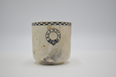 Geelong Naval and Maritime Museum
Teacup
The Orungal was originally built in Glasgow in 1923 for the Khedival Mail Steamship & Graving Dock Company of Egypt and named the S.S. Fezara. Due to the effects on steamship companies of the Great Depression including the steep costs of building new ships and increases in running costs and port charges, no new passenger ships had been ordered in Australia since before World War One. To meet demand for passenger berths, the Fezara (5826 tons) along with its sister ship the Famaka (5856 tons, renamed Ormiston), were chartered by the Australasian United Steam Navigation Company Ltd (A.U.S.N.Co.) in 1927. Both the A.U.S.N.Co and the Khedival Mail Steamship Co. were part of the P&O Group. The Orungal operated in this role as an interstate passenger and mail steamer between 1927 and 1940, being used mainly on the Melbourne to Queensland and Western Australian runs, with 240 single class berths. Following the outbreak of World War Two six of the nine large passenger liners servicing mainland Australian passenger and mail trades were requisitioned by the Government to ferry equipment, troops and supplies. Some of them were converted to armed merchant cruisers and used for patrol work and escort duties in the Indian and Pacific Oceans. The Orungal had originally been requisitioned by the government along with the Zealandia on 25 June 1940, to transport troops to Darwin, but was returned to commercial service because "of her unsuitability", perhaps too slow for the demands of the work. Despite being rejected for patrol and convoy duties the Orungal still had a vital role as one of only three passenger liners left to service the mainland Australian trade. Following its requisitioning by the Government shortly after war broke out, it had been fitted out with defensive armament. On its final voyage arriving at Port Phillip Heads from Sydney, Captain Gilling was attempting to enter the Heads ahead of a worsening south-westerly storm and, with a minefield known to have been laid in the area, had been warned by the Navy not to deviate from the swept channel. The captain and crew held fears that in the stormy seas a mine may have been carried away. In the worsening weather a blur of lights at Barwon Heads was mistaken for Port Lonsdale, and the Orungal steamed ashore onto Formby Reef, just east of the entrance of the Barwon River - instead of passing safely through the middle of the Rip. At the Marine Board Inquiry Capt. Gilling - who had been master of the Orungal since 1926 - stated that after becoming uneasy about his position and changing course to starboard one point: " At 10.21 pm I ordered the engine room to stand by and gave instructions for the patent log to be hauled in and for the sounding-gear to be got ready. Approximately two minutes later, in a flash of lightning, I saw land off the port beam. I immediately recognised it as Barwon Heads, and ordered the helm to be put hard to starboard, but the vessel struck before she had time to answer the helm" Barwon Heads and Ocean Grove residents were startled to hear the shrill blast of the ship's whistle, followed by the bright flares and explosions of signal rockets. The Queenscliff lifeboat crew, who had responded to the tragic collision between the Goorangai and another passenger liner the Duntroon in Port Phillip Bay less than 24 hours earlier, were later praised for their efforts in safely taking off all the passengers and crew. Most of the passengers were asleep at the time of the wreck, and were woken up by the commotion, the ship shaking "from stem to stern" and stewards ordering them to lifeboat stations in driving rain. It was a dramatic time with the ship siren wailing and distress rockets being fired. It was reported that "When it was found the ship was safe, the passengers all went to the music room. There they sang and danced for several hours. The ship's orchestra played merrily, and amateur performers among the passengers clowned, danced and sang to keep the laughter going. In the early hours of the morning passengers went to their cabins, most of them to sleep soundly while the keel grated on the rocks". At dawn the Queenscliff lifeboat arrived at the scene having been launched at 2.30am, and cautiously approached the ship which was being "battered by mountainous seas". By 5am oil from a burst oil line was helping to calm seas around the Orungal sufficiently enough for the lifeboat to approach, and all the passengers and crew were taken off in several trips by the lifeboat. A Court of Inquiry later found that the wreck was caused by an abnormal set of current to the north-west and cleared the officers and crew of neglect of duty. The sight of a huge liner almost on the beach saw an unprecedented amount of traffic as people drove an estimated 10,000 cars, using some 60,000 gallons of fuel in a time of strict petrol rationing, to see the spectacle. Salvage operations began in an attempt to refloat the vessel, scheduled for the high tide on 15 December 1940. However, during these operations, at 2.30 am on 13 December 1940, a major fire broke out, believed to have been caused by spontaneous combustion in the boiler room. The ship was soon ablaze, with smoke pouring from its hatches and ventilators, and at mid-morning the magazine exploded fiercely. Of the 60 men working aboard the vessel two were severely burned and had to be taken to Geelong Hospital. The gathered spectators witnessed the eerie sight of the ship's hull glowing red when night fell. The well-known building demolition contractor Whelan the Wrecker bought the salvage rights, and methodically proceeded to dismantle the ship and its fittings. The drama was not yet over for the wreckers when - without warning - the burnt-out hulk was 'attacked' by RAAF for strafing practice. Salvage rights were transferred to another private owner in 1963. By 1945 the combined effects of the exposed location, fire and salvage had seen what was left of the wreck disappear beneath the waves. The site today is marked by two of the four Scotch type boilers sitting upright and exposed at low tide, just north-east of the small boats channel at the entrance to Barwon Heads. Large sections of steel hull plating and framing, and impressively large pieces of ships structure and machinery including masts, booms, deck winches, propeller shaft, flywheel, and a thrust block lie scattered about and make the site an interesting shallow dive. It is interesting to compare the site of the Orungal with the intact remains of similar large passenger ships scuttled in deep water in the Ships' Graveyard, such as the Milora and Malaita. The site is subject to waves and surge, and is best dived on flat calm days The teacup originated from the SS Orungal and was likely used heavily in the ship's life as a passenger, mail and cargo carrier around Australia. The teacup is significant for its connections to SS Orungal and of this ships connected story of being sunk in extraordinary circumstances in the local region. A.U.S.N. Co. Ltd. Teacup salvaged from SS Orungal ss orungal, fezara, world war two, barwon heads, ocean grove -
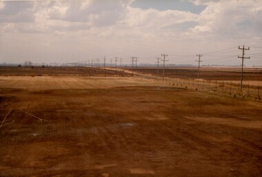 Westbourne Grammar Heritage Collection
Photograph - The Site for Westbourne 1977
In 1975 a School Council subcomittee was formed to select a new principal to instigate the development of secondary schooling at Williamstown Grammar. By 1977 the appointed principal, John Roberts Pascoe, had worked tirelessly assessing options in and around Williamstown and looking for support for the school's expansion plans. He found that support in the Werribee Council and Werribee community, which recognised the potential of an independent school for the expanding area. In 1977, based on demographic research and feasibility studies, fifty acres of land was purchased on Sayers Rd. at Truganina (then Werribee). This photograph shows that land, the site for the new secondary school for Williamstown Grammar, looking east at the corner of Sayers Rd & Marquands Rd, which would be a very different view today.Colour photograph of a cloudy sky and cleared land with a perspective line of telegraph poles extending from the right into the middle background.campus, secondary, expansion -
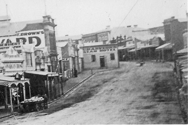 Stawell Historical Society Inc
Photograph, Enlargement of Catalogue number 0541 of Main Street looking East featuring the Star Hotel, 1890's
Enlargement of right hand side of photo 0541. Top end of Main St. looking East towards Big Hill. From left Herbert Photographic, T Brown, Star Hotel on bend jutting out into middle of road. Mechanics Institute in background. Two Horse wagon in street on left.stawell businesses streetscape -
 National Trust of Australia (Victoria)
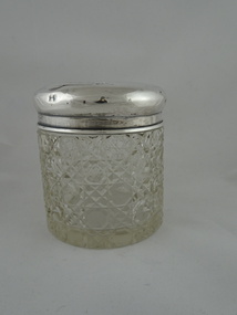
Hair tidy, 1908
Belonged to Mrs Emma Winifred Hornabrook [nee Sargood]. Winnie Sargood was one of the middle children of the large Sargood family, and grew up at Rippon Lea.[Sterling silver] cylindrical lidded transparent glass crystal hair tidy. RL 0791.1: Cylindrical container has a flat circular base. The glass is decorated with cut and faceted design comprised of two diagonal parallel lines forming diamonds in which are octagonal shapes. RL 0791.2: Silver convex lid with a circular hole in the centre. The surface is smooth except for engraved lettering in calligraphic style around central opening.Engraved onto top of metal lid: Winnie/ Hair Tidy; hallmarks: ..D/WD in a shield, anchor, lion, D. •Stamped into metal on outer rim of lid: [Hallmarks] [makers mark]/[anchor]/ [Lion]/I •Stamped into metal on inner rim of lid: [Hallmarks]/0/C/0/sargood, emma winifred, rippon lea, hornabrook, emma winifred [nee sargood] -
 Whitehorse Historical Society Inc.
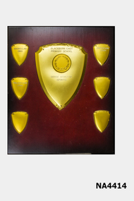
Decorative object - Trophy
See Ref. 4362Oblong wooden shield with large shield in the middle with a circular medallion in the centre of a large metal shield. This is surrounded by six small metal shields. |Large metal shield engraved 'Blackburn East Primary School - House Athletics Sports'.|Smaller Shields:|1. Mackellar 1983-2. Paterson 1984-3. Mackellar 1985See abovetrophies & awards, sports