Showing 1810 items matching "planning and development"
-
 Port Melbourne Historical & Preservation Society
Document - Planning brief, Ewan Ogilvy's Bayside Papers, Box One, 1987 - 1998
Ewan Ogilvy, former Melbourne Councillor and also of Community Services Victoria, Inner Urban Ministerial Advisory Committee and Uniting Church's Centre for Urban Research and Action (CURA), was instrumental in social justice approaches to town planning. He and CURA's Social Justice and the City Project funded Port Melbourne community groups protesting against the SCDC development in 1987. His files were presented to the Society in May 2001 on his preparation for leaving VictoriaFrom Ewan Ogilvy's chronologically organised 'Bayside Papers' relating to the proposed development of Port Melbourne industrial land in the late 1980s: Port Melbourne Bayside project Environmental Effects and Draft Development Brief March 1986All items signed 'Ewan Ogilvy'town planning, town planning - proposals shelved - bayside, public action campaigns, environmental issues, ewan ogilvy, centre for urban research and action -
Port Melbourne Historical & Preservation Society
Book - Main report, Ewan Ogilvy's Bayside Papers, Box One: Bayside Project EES Statement Vol.1, 1987 - 1998
Ewan Ogilvy, former Melbourne Councillor and also of Community Services Victoria, Inner Urban Ministerial Advisory Committee and Uniting Church's Centre for Urban Research and Action (CURA), was instrumental in social justice approaches to town planning. He and CURA's Social Justice and the City Project funded Port Melbourne community groups protesting against the SCDC development in 1987. His files were presented to the Society in May 2001 on his preparation for leaving Victoria.From Ewan Ogilvy's chronologically organised 'Bayside Papers' relating to the proposed development of Port Melbourne industrial land in the late 1980s: Port Melbourne Bayside project Environmental Effects Statement for SCDC proposal Volume 1 Main Report July 1987All items signed 'Ewan Ogilvy'town planning, town planning - proposals shelved - bayside, public action campaigns, environmental issues, ewan ogilvy, centre for urban research and action -
Port Melbourne Historical & Preservation Society
Book - Technical Appendices, Ewan Ogilvy's Bayside Papers, Box One: Bayside Project EES Statement Vol.2, 1987 - 1998
Ewan Ogilvy, former Melbourne Councillor and also of Community Services Victoria, Inner Urban Ministerial Advisory Committee and Uniting Church's Centre for Urban Research and Action (CURA), was instrumental in social justice approaches to town planning. He and CURA's Social Justice and the City Project funded Port Melbourne community groups protesting against the SCDC development in 1987. His files were presented to the Society in May 2001 on his preparation for leaving Victoria.From Ewan Ogilvy's chronologically organised 'Bayside Papers' relating to the proposed development of Port Melbourne industrial land in the late 1980s: Bayside project Environmental Effects Statement for SCDC proposal Volume 2: Technical Appendices July 1987All items signed 'Ewan Ogilvy'town planning, town planning - proposals shelved - bayside, public action campaigns, environmental issues, ewan ogilvy, centre for urban research and action, sandridge city development co pty ltd, scdc -
Port Melbourne Historical & Preservation Society
Document - SCDC Report, Ewan Ogilvy's Bayside Papers, Box One, 1987 - 1998
Ewan OGILVY, former Melbourne Councillor and also of Community Services Victoria, Inner Urban Ministerial Advisory Committee and Uniting Church's Centre for Urban Research and Action (CURA), was instrumental in social justice approaches to town planning. He and CURA's Social Justice and the City Project funded Port Melbourne community groups protesting against the SCDC development in 1987. His files were presented to the Society in May 2001 on his preparation for leaving Victoria.From Ewan OGILVY's chronologically organised 'Bayside Papers' relating to the proposed development of Port Melbourne industrial land in the late 1980s: Sandridge City Development Corporation report on hydraulic model testing and comp. modelled traffic estimates September 1987All items signed 'Ewan Ogilvy'town planning, town planning - proposals shelved - bayside, public action campaigns, environmental issues, transport - motor vehicles, ewan ogilvy, centre for urban research and action, sandridge city development co pty ltd, scdc -
Port Melbourne Historical & Preservation Society
Document - SCDC Report, Ewan Ogilvy's Bayside Papers Box One, 1987 - 1998
Ewan Ogilvy, former Melbourne Councillor and also of Community Services Victoria, Inner Urban Ministerial Advisory Committee and Uniting Church's Centre for Urban Research and Action (CURA), was instrumental in social justice approaches to town planning. He and CURA's Social Justice and the City Project funded Port Melbourne community groups protesting against the SCDC development in 1987. His files were presented to the Society in May 2001 on his preparation for leaving Victoria.From Ewan Ogilvy's chronologically organised 'Bayside Papers' relating to the proposed development of Port Melbourne industrial land in the late 1980s: Extra photocopies of all documents in 1390.06, bound only with bulldog clipAll items signed 'Ewan Ogilvy'town planning, town planning - proposals shelved - bayside, public action campaigns, environmental issues, public housing, ewan ogilvy, centre for urban research and action, sandridge city development co pty ltd, scdc, tom roper, evan walker -
Port Melbourne Historical & Preservation Society
Archive - File, Ewan Ogilvy's Bayside Papers, Box Two: Bayside EES Hearing Transcripts, CSV and Ministerial Advisory Committee Submissions, 1987 - 1998
Ewan Ogilvy, former Melbourne Councillor and also of Community Services Victoria, Inner Urban Ministerial Advisory Committee and Uniting Church's Centre for Urban Research and Action (CURA), was instrumental in social justice approaches to town planning. He and CURA's Social Justice and the City Project funded Port Melbourne community groups protesting against the SCDC development in 1987. His files were presented to the Society in May 2001 on his preparation for leaving Victoria.From Ewan Ogilvy's chronologically organised 'Bayside Papers' relating to the proposed development of Port Melbourne industrial land in the late 1980s: Bound file of EES Inquiry transcripts and CSV and Ministerial Advisory Committee reports, including Ministerial briefing 22.06.1987 to 05.10.1987Signed 'Ewan Ogilvy'; 'Áttachment 2' on first pagetown planning, town planning - proposals shelved - bayside, public action campaigns, environmental issues, public housing, missions to seamen, ewan ogilvy, centre for urban research and action, sandridge city development co pty ltd, scdc, terry chumbley, linton r lethlean, peter atkins, david spokes -
Port Melbourne Historical & Preservation Society
Archive - File, Ewan Ogilvy's Bayside Papers, Box Two: Bayside Press Cuttings, 1987
Ewan OGILVY, former Melbourne Councillor and also of Community Services Victoria, Inner Urban Ministerial Advisory Committee and Uniting Church's Centre for Urban Research and Action (CURA), was instrumental in social justice approaches to town planning. He and CURA's Social Justice and the City Project funded Port Melbourne community groups protesting against the SCDC development in 1987. His files were presented to the Society in May 2001 on his preparation for leaving Victoria.From Ewan OGILVY's chronologically organised 'Bayside Papers' relating to the proposed development of Port Melbourne industrial land in the late 1980s, bound file: 'Bayside' press cuttingsAll items signed 'Ewan Ogilvy'town planning, town planning - proposals shelved - bayside, public action campaigns, environmental issues, public housing, missions to seamen, centre for urban research and action, sandridge city development co pty ltd, scdc, linton r lethlean, ewan ogilvy, barry pullen -
Port Melbourne Historical & Preservation Society
Archive - File, Ewan Ogilvy's Bayside Papers, Box Two: Submissions, 1987
Ewan Ogilvy, former Melbourne Councillor and also of Community Services Victoria, Inner Urban Ministerial Advisory Committee and Uniting Church's Centre for Urban Research and Action (CURA), was instrumental in social justice approaches to town planning. He and CURA's Social Justice and the City Project funded Port Melbourne community groups protesting against the SCDC development in 1987. His files were presented to the Society in May 2001 on his preparation for leaving Victoria.From Ewan OGILVY's chronologically organised 'Bayside Papers' relating to the proposed development of Port Melbourne industrial land in the late 1980s: bound fille containing submissions from Community Services Victoria, Port Melbourne City Council, ALP, Port Melbourne Citizens Action Group, correspondence, minutes and notes from meetings attended etc.Signed 'Ewan Ogilvy', additions to titletown planning, town planning - proposals shelved - bayside, public action campaigns, environmental issues, public housing, missions to seamen, ewan ogilvy, centre for urban research and action, sandridge city development co pty ltd, scdc, linton r lethlean, barry pullen - mlc -
Port Melbourne Historical & Preservation Society
Archive - File, Bayside Project Bill, Ewan Ogilvy's Bayside Papers, Box Three, 1987
Ewan Ogilvy, former Melbourne Councillor and also of Community Services Victoria, Inner Urban Ministerial Advisory Committee and Uniting Church's Centre for Urban Research and Action (CURA), was instrumental in social justice approaches to town planning. He and CURA's Social Justice and the City Project funded Port Melbourne community groups protesting against the SCDC development in 1987. His files were presented to the Society in May 2001 on his preparation for leaving Victoria.From Ewan Ogilvy's chronologically organised 'Bayside Papers' relating to the proposed development of Port Melbourne industrial land in the late 1980s: Bayside Project Bill documents including VP Hansard, copy of Act and of memorandum (a and b) plus related correspondence and documents, bound in clear fileSigned 'Ewan Ogilvy'town planning, town planning - proposals shelved - bayside, public action campaigns, environmental issues, public housing, missions to seamen, ewan ogilvy, centre for urban research and action, sandridge city development co pty ltd, scdc, linton r lethlean, barry pullen - mlc -
Port Melbourne Historical & Preservation Society
Document, Ewan Ogilvy's Bayside Papers, Box Three - Inner Urban Ministerial Advisory Committee - Report on Social Impact Work for major Developments Jan 1988, 1987
Ewan Ogilvy, former Melbourne Councillor and also of Community Services Victoria, Inner Urban Ministerial Advisory Committee and Uniting Church's Centre for Urban Research and Action (CURA), was instrumental in social justice approaches to town planning. He and CURA's Social Justice and the City Project funded Port Melbourne community groups protesting against the SCDC development in 1987. His files were presented to the Society in May 2001 on his preparation for leaving Victoria.From Ewan Ogilvy's chronologically organised 'Bayside Papers' relating to the proposed development of Port Melbourne industrial land in the late 1980s: Stapled photocopies of Inner Urban Ministerial Advisory Committee - Report on Social Impact Work for major Developments Jan 1988Signed 'Ewan Ogilvy'town planning, town planning - proposals shelved - bayside, public action campaigns, environmental issues, public housing, missions to seamen, ewan ogilvy, centre for urban research and action, sandridge city development co pty ltd, scdc, linton r lethlean, barry pullen - mlc -
Port Melbourne Historical & Preservation Society
Legal record, Ewan Ogilvy's Bayside Papers, Box Three - Port Melbourne Bayside Development Development Agreement - contract of sale, 1987
Ewan Ogilvy, former Melbourne Councillor and also of Community Services Victoria, Inner Urban Ministerial Advisory Committee and Uniting Church's Centre for Urban Research and Action (CURA), was instrumental in social justice approaches to town planning. He and CURA's Social Justice and the City Project funded Port Melbourne community groups protesting against the SCDC development in 1987. His files were presented to the Society in May 2001 on his preparation for leaving Victoria.From Ewan Ogilvy's chronologically organised 'Bayside Papers' relating to the proposed development of Port Melbourne industrial land in the late 1980s: Stapled photocopies of Port Melbourne Bayside Development Development Agreement - contract of saleRust marks from bulldog clip top front cover. Signed 'Ewan Ogilvy'town planning, town planning - proposals shelved - bayside, public action campaigns, environmental issues, public housing, missions to seamen, ewan ogilvy, centre for urban research and action, sandridge city development co pty ltd, scdc, linton r lethlean, barry pullen - mlc -
 Bayside Gallery - Bayside City Council Art & Heritage Collection
Map - print, Melbourne and Metropolitan Board of Works, Interim development order: Brighton, Moorabbin and Sandringham, 1959
The Melbourne and Metropolitan Board of Works (now Melbourne Water) was established in 1891. From that time, as part of their work laying water and sewerage connections, they created detailed plans of houses and other buildings in the Melbourne metropolitan area. In 1956 it acquired powers to construct and maintain highways and bridges, protect and improve the foreshores and create and maintain parks within the metropolitan region. This Interim development order comprises part of the municipalities of Brighton, Moorabbin and Sandringham and was made on 20 October 1959.brighton, moorabbin, sandringham, melbourne and metropolitan board of works, map, town planning, cartographic material, interim development order, bayside -
Ballarat Tramway Museum
Document - Draft, State Electricity Commission of Victoria (SECV), Notes for statement by the Commission - Ballarat Inquiry", July 1958
Document titled "Notes for statement by the Commission - Ballarat Passenger Transport Inquiry". Gives notes on the early history, SEC Development, SECV Agreement, Municipal By-Laws, future planning, rehabilitation, Physical features at Ballarat, operational review (missing some figures), fares and fare revisions between 1935 and 1958, tables of staff (missing figures) tramcars, review of present operations, and prospective costs of continuation. Has tables of profit and loss, expenditure by type and operational statistics.Yields information about the 19583 TRB Enquiry into the closure of Ballarat Tramways.Document - 26 foolscap pages with rounded corners, pinned in the top left hand corner. Has a card backing."Copy taken 30/7/58" in ink top right hand corner.tramways, trb, enquiries, enquiry, closure, ballarat, statistics, rehabilitation -
Port Melbourne Historical & Preservation Society
Book, Kate Shaw et al, Ewan Ogilvy's Bayside Papers, Box Three - Bayside Views - A Collection of critical perspectives on the Bayside Development, 1988
Ewan OGILVY, former Melbourne Councillor and also of Community Services Victoria, Inner Urban Ministerial Advisory Committee and Uniting Church's Centre for Urban Research and Action (CURA), was instrumental in social justice approaches to town planning. He and CURA's Social Justice and the City Project funded Port Melbourne community groups protesting against the SCDC development in 1987. His files were presented to the Society in May 2001 on his preparation for leaving Victoria.From Ewan OGILVY'S chronologically organised 'Bayside Papers' relating to the proposed development of Port Melbourne industrial land in the late 1980s: Bayside Views - A Collection of critical perspectives on the Bayside Development, a book of essays on Bayside issues, 1988 - funded by the Justice in the City projectSigned 'Ewan Ogilvy'town planning, town planning - proposals shelved - bayside, public action campaigns, environmental issues, public housing, missions to seamen, centre for urban research and action (cura), uniting church, sandridge city development co pty ltd, scdc, linton r lethlean, barry pullen, ewan ogilvy -
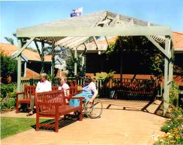 Broadmeadows Historical Society & Museum
Photograph, Meeting under the Pergola to Chat, Banksia Gardens, 1998, 3 February 1998
"Meeting Under the Pergola to Chat" is part of the Banksia Gardens collection from 1998. It captures a moment of social interaction within a public space designed for residents of social housing to meet and engage with their neighbours. This image highlights the significance of communal areas in fostering a sense of community and belonging among residents. The pergola serves as a focal point for social gatherings, reflecting the thoughtful urban planning aimed at enhancing social cohesion and quality of life in the housing development during that period.The photograph titled "Meeting Under the Pergola to Chat" is part of the Banksia Gardens collection from 1998. It depicts social housing with public spaces designed for neighbours to meet and interact. This image captures the essence of community life and the importance of shared spaces in fostering social connections within the housing development. The photograph not only documents the architectural and social planning of the era but also highlights the value placed on communal areas for enhancing the quality of life for residents.Colour photograph on glossy photographic paper."Pergola where neighbours meet to chat, Public Housing"/"Banksia Gardens 1998"social housing, banksia gardens, pergola, meeting place, 1998 -
 Eltham District Historical Society Inc
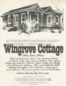
Document - Property Binder, 672 Main Road, Eltham
Flyer, Neville Emerson Pty Ltd, for sale Wingrove Cottage. Shire of Eltham Heritage Study, nd but post 1989: Wingrove Cottage. Note: June 1997 re Judy David, descendant of Mr Wingrove. Note: 2 September 2003: Greg Johnson description of building. Statement 2 September 2003 from Francis Percival (Jock) Read of memories of Wingrove Cottage. Copy letter 21 October 2002 from Value Creating Environments (recent purchasers of Wingrove site) to John Karageorge Planning and Building Services Nillumbik Shire re planned work; also attachment re possible site development. Newspaper article: Diamond Valley Leader, 23 October 2002, Angry crowd stops demolition, photograph of part demolition. Letter 30 December 2002 from Stephen Coleriro Acting Manager Planning and Building Services Nillumbik Shire re consultation on illegal demolition works at Wingrove Cottage. Letter 24 February 2003 from Allom Lovell & Associates to John Karageorge Shire of Nillumbik commenting on Wingrove Cottage work. Newspaper article: Diamond Valley Leader, 17 September 2003, Court orders restoration at cottage. Newspaper article: Diamond Valley Leader, 25 February 2004, Health vision for Eltham's 1800s home, Wingrove Cottage will be restored as health and wellness centre if plans approved. Newspaper article: Diamond Valley Leader, 7 July 2004, 1850s bricks in debris, Jim Cummane owner ordered to prepare conservation plan, photograph of site and Harry Gilham president Eltham District Historical Society. Newspaper article: Diamond Valley Leader, 1 December 2004, Cottage heritage plan crucial to sale success, site to be sold, photograph of Wingrove Cottage. Letter 14 April 2005 from Gaye Van Donkelaar Planning and Building Services Nillumbik Shire to Russell Yeoman Eltham District Historical Society re meeting of key stakeholders 27 April 2005. Newspaper article: Diamond Valley Leader, 28 March 2007, Cottage work on hold, recent purchasers Cameron Construction restored Cottage, open as photographic studio, applied for permit to build office and 7 homes on site. Letter 13 August 2007 from Senior Registrar VCAt to Eltham District Historical Society enclosing VCAT order re application for 672 Main Road. Letter 24 August 2007 from Colin Bowden Planning and Development Consultants to VCAT enclosing response prepared by O'Brien Traffic for VCAT. Letter 14 February 2007 from Jeremy Livingstone Planning and Building Services Nillumbik Shire, invitation to review re planning application.main road, eltham, property, houses, wingrove cottage -
 University of Melbourne, Burnley Campus Archives
Plan, Water Garden & Grassy woodland, 1987-1995
(1) Water Garden V.C.A.H Burnley Irrigation Plan, drawn by M.D. 12.11.87. (2) Tracing paper copy, Proposed Pool Development Native Garden V.C.A.H. Burnley -Survey of approximate dimensions showing fall and depth of pools. Drawn by J.H.K. 9.9.88. (3) Rough coloured plan, Water Garden Planting Plan. (4) Proposed Water Garden V.C.A.H. Burnley by Robert W. Boyle and Associates October 1988, with handwritten annotations by James Hitchmough. (5) Coloured final version. (6) Tracing paper copy, Planting Scheme Native Garden VCAH Burnley. Design by James Hitchmough. Drawing J.K. 13.8.90. (7) Section Native Grassland Burnley Campus - Larger Tree Cover by Marika Kocsis & Martin Hopkins. Drawn by Leigh Stone 25.9.95. Survey Plan, no key to numbers. (8) Section Native Grassland by Marika Kocsis & Martin Hopkins. Drawn by Leigh Stone 20.9.95. No key to numbers. (9) Tracing paper copy Native Garden by Paul Eaves 6.9.90. Scale 1:100. Also 2 plant lists (11.0478/1 and /2). Also see 11.0478 List of plants. (11) Letter to P. Tulk from Robert Boyle dated 07.10.1988 "Re: Cost Estimates for Construction of Proposed Water Garden."water garden, vcah, robert w. boyle, james hitchmough, jill kellow, marika kocsis, martin hopkins, leigh stone, paul eaves -
 Eltham District Historical Society Inc
Document - Report, Paul Jerome, Advisory Committee on a Proposed Convenience Centre and an Alternative Shire Proposal - Eltham Gateway Community Precinct Concept Plan - 895 Main Road Eltham, October 1997
On 15 December 1994 the former Shire of Eltham ceased to exist following the Liberal Kennett Government local council amalgamations. A new Nillumbik Shire Council was established with unelected commissioners appointed. That Council sold the former Eltham Shire Council Offices and land at 89S Main Road Eltham to Dallas Price Homes Pty. Ltd. the sale being conditional upon the granting of a planning permit for a petrol station/convenience store, fast food and video outlet. The sale was conditional that if the permit was not granted by 30 August. 1997, the contract could be avoided by either the purchaser or the vendor. The proposed development consisted of a petrol station with undercover fuelling facilities, convenience shopping, a drive through service facility for fast food, an 80 seat cafe, automated banking, a children's play area and retail space. In addition, the proposal included a 200 square metre community facility for Council use, provision of on site carparking over 2 levels for 83 vehicles, and advertising signage. An Advisory Committee consisting of Dimitry Reed and Margaret Pitt was appointed under Section 151 of the Planning and Environment Act 1987 to hear submissions on the proposal to develop the land at 895 Main Road Eltham, the site of the former Eltham Shire Offices. In September 1996, two applications were made by Contour Consultants Australia Pty Ltd on behalf of Dallas Price Homes Ply Ltd, to Nillumbik Shire Council. After extensive notification, the Council received 213 objections and a petition of over 1400 signatures. On October 9, 1996, Nillumbik Shire Council issued Notices of Decision to Grant Permit on Applications number 96/03376 and 96/0377 for the use and development of the land as a convenience Centre consisting of a petrol station, convenience store, cafe/takeaway food premises, a retail facility and a community facility, with associated advertising signs. Objectors to the proposals lodged Planning Appeals number 96/40724 and 96/40812 with the Administrative Appeals Tribunal on November 1, 1996. The grounds of appeal can be summarised as: inappropriate development, insufficient carparking, traffic and access issues, unsatisfactory design, inadequate permit conditions, the proposal being out of character with the area. and being contrary to the purpose and orderly development of the Eltham Town Centre, excessive noise, lack of consultation and unsuitable signage. On November 13, 1996, the Minister for Planning and Local Government directed the Registrar of the Administrative Appeals Tribunal. under Section 41 (1) (a) of the Planning Act 1980, to refer the Appeals to the Governor in Council for determination without a hearing or recommendation by the Tribunal. The Minister for Planning and Local Government called in the Appeals as he considered that they raised major issues of policy relating to the facilitation of development in accordance with the objectives set out in Section 4 of the Planning and Environment Act 1987, and that determination of the Appeals could have a substantial effect on the achievement of these planning objectives. The Minister required the Advisory Committee to consider the planning merits of the proposed use and development, and to address the issues raised in the objections. The Advisory Committee was required to produce a report providing: • The Committee's response to the matters detailed; • Relevant supporting information for the Advisory Committee's recommendation; and • A description of the proceedings conducted by the Advisory Committee and a list of those consulted or heard by the Committee. In March 1997, elections were held in the Shire of Nillumbik and the view of the new Council to this proposal differed from the view held by the earlier Council Hence the Submission made to the Committee by the Shire was against the decision by the Shire of Nillumbik to issue the Notices of Decision to Grant a Permit. The Recommendations of the Advisory Committee were: i. The cafe and take away food premises are as of right uses and are therefore allowable, but that shop and petrol station are unacceptable uses. A community facility is a discretionary use and is acceptable. ii. A development of the type and scale proposed is totally inappropriate for this land and that the Applications number 96/03376 and 96/0377 for the use and development of the land as a convenience Centre consisting of a petrol station, convenience store, café/takeaway food premises, a retail facility and a community facility, with associated advertising signs, be refused. iii. The land should be rezoned for public purposes and should remain in the community's ownership for community use. Following this, the Minister for Planning and Local Government, the Hon. Robert Maclellan, appointed Mr. Paul Jerome as an Advisory Committee under section 151 of the Planning and Environment Act 1987 to consider a Convenience Centre and an alternative proposal by Iha Shire of Nillumbik being the Eltham Gateway Community Precinct Concept Plan for the site of the former Shire of Eltham municipal offices at 895 Main Road, Eltham. In summary, the terms of reference for the Advisory Committee required it to: • consider the merits of the Council proposal • examine the merits of both proposals in terms of net community benefit • address the report of the previous Advisory Committee on the Convenience Centre proposal The Advisory Committee inspected the site and considered all the material before It including submissions made by all parties to the previous Advisory Committee and correspondence received by the Department of Infrastructure both before and after that Committee submltted its report. The Advisory Committee also held discussions with the following people: • Cr. Robert Marshall • Cr. Margaret Jennings • Cr. Lex de Man • Mr. Dallas Howgate of Dallas Price Properties, also Dallas Price Homes • Mr. Barry Rochford, CEO, Shire of Nillumbik • Ms. Yvonne Rust, Planning Officer, Shire of Nillumbik • Mr. Gregory Burgess, Architect of the Eltham Library and of Council’s Community Precinct Concept Plan • Mr. Jim Connor representing Mrs Thelma Barkway of the Eltham Senior Citizens Club Having considered all the material before it, the Committee arrived at two basic conclusions. First, the DPP proposal should be rejected because, on its merits, It does not sufficiently satisfy the requirements of the planning scheme which is a statutory document. The planning scheme requires that, before making a decision on the permit applications for the DPP proposal, a range of matters must be considered. It follows that consideration of these matters should Influence the decision. These matters include local policies relating to character and amenity. In particular, these policies seek • to conserve and enhance the bushland/country atmosphere, artistic heritage and strong sense of community of the Eltham Town Centre by ensuring that the design and height of any new development is sympathetic to existing buildings • to achieve a pleasing physical environment within the Eltham Town Centre by encouraging a high standard of architecture and urban design • to encourage Improvement to pedestrian amenity through such facilities as open and shattered rest areas and meeting places, crossing facilities, pedestrian arcades, pedestrian links to car parks and pedestrian weather protection • to reduce conflict between vehicular traffic and pedestrian flows, and • to encourage pedestrian thoroughfares It is submitted, as set out In the main body of this report, that the DPP proposal fails substantially to meet these policies and In so doing does not merit the exercise of discretion In Its favour with the Issuing of a permit. This finding is not offset by the investment and employment attributes of the proposal. They do not override the need to comply with the planning scheme. Second, the Council proposal, on Its own merits, substantially meets all statutory requirements applicable to this site with a possible reservation about car parking and traffic management which need further definition and assessment as the concept is refined. The Council proposal, however, has a serious weakness in that Its financial viability has not been adequately tested. The Committee refers to 'financial' rather than 'commercial' viability in recognition that Council owns the land and may enter into a range of agreements and partnerships to realise its concept some of which may be truly commercial and some of which may involve an element of subsidy arising from Council's involvement as a public body acting on behalf of its community. The Committee concludes that Council should be given the opportunity, within a reasonable timeframe to establish the financial feasibility of its concept and should develop a strategy for the future of Its land asset at 895 Main Road in the event that Its concept for the site cannot be realised. 895 main road, advisory committee, dallas price homes, eltham, eltham shire office, nillumbik shire council, planning application, administrative appeals tribunal -
 Eltham District Historical Society Inc
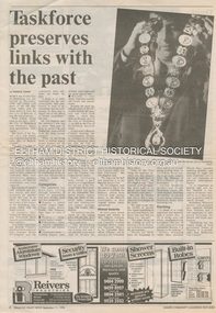
Document - News Clipping, Natalie Town, Taskforce preserves links with the past, Diamond Valley News, September 11, p8, 1996
About former Shire / City council memorabilia. On the reverse side an article "Timing was the problem: chief" regarding Nillumbik CEO Barry Rochford dismissing claims that coulcil failed to follow correct statutory procedure when announcing the release of development plans for thje former Eltham Shire Office site in which developer Dallas Howgate intended to build a service station, convenience store, fast food outlet and community facilities including an information desk and meeting area.895 main road, barry rochford, bev marshall, dallas howgate, eltham shire office, nillumbik shire council, banyule city council, city of heidelberg, david hay, heidelberg historical society, honour board, joint memorabilia taskforce, mayoral chain, peter williams, roma o'callaghan, shire of diamond valley, shire of eltham -
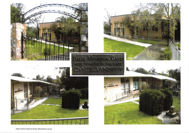 Eltham District Historical Society Inc
Document - Folder, Eltham War Memorial Complex, 1961
Background context for the establishment of the Eltham War Memorial as a living memorial, championed by the women of the community with the establishment of the Eltham War Memorial Trust and how the memorial was funded by public donations and eventually handed over to Council. The essay came about in 2018 following community protest at Council's plans to sell the land. Following abandonment of the sale process and putting development on hold, community groups pulled together to apply for heritage protection of the site with Heritage Victoria. This was formally rejected in May 2020.Contents: An essay addressed to the Councillors of Nillumbik Shire, October 2018: About the Eltham War Memorial and the adjacent community-owned sites in Eltham that the Council threatens to sell, Andrew Lemon Nov. 2018 Public Notice: Heritage Act 2017, Recommendations to the Heritage Council, Heritage Council Victoria, The Age, May 22, 2020, p34eltham war memorial, eltham war memorial trust, mrs. ada lyon, mrs. cairns officer, mrs. j.j. morrison, andrew lemon, children's library, eltham war memorial garden, eltham war memorial gate, eltham war memorial hall, garden of remembrance, heritage council victoria, nillumbik shire council, theodore feldbauer, violet feldbauer (nee teagle) -
 Falls Creek Historical Society
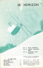
Journal - Ski-Horizon Vol 6 No 2
Ski-Horizon is the official journal of the Federation of Victorian Ski Clubs which began publication in 1949. The were 26 original member clubs which included Albury Ski Club, Bogong Ski Club, Myrtleford Ski Club, Tallangatta and District Ski Club and Wangaratta Ski Club. Two pioneers of Falls Creek, Tom Mitchell, M.L.A., and Martin Romuld were Vice-Presidents of the Federation.This Journal is significant because it documents the early development of skiing in Victoria.The journal features stories and events chronicling developments in Victoria and internationally. Items related to the Falls Creek Area in this issue include:- Cover - Rudi Wurth, winner of the National Slalom and Downhill titles at Kosciusko, 1954. Page 3 - Commercial ventures are prospering in Falls Creek. Plans ahead for developments at Nissen Tow. Betty Plunkett will spend the year on the snow helping Skippy with the canteen. Les Mikel will help Toni with the tow. Bob Hymans and his wife leave for Europe soon to get fresh ideas and equipment. Bob intends to install a £15,000 chair lift with special cable which allow it to go round corners. Page 5 - Fred Griffith, President of the Falls Creek Alpine Village Advisory Committee has been in Melbourne lobbying for Government help to build a comfort station to provide facilities for a ski patrol shelter - aided and abetted by a "well known skiing M.L.A. toni st. elmo, skippy st. elmo, bob hymans, nissen ski tow, fred griffith -
 Eltham District Historical Society Inc
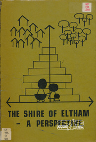
Book, Shire of Eltham, The Shire of Eltham - A Perspective, July 1981
... planning ...This report was produced by the Shire of Eltham (Planning Department) following a population study of the Shire. It also includes other areas of general interest. The Document contents includes Present and Future - Population - Housing - Residential Lands - Social Characteristics - Development and History. Includes maps, tables and diagrams. Part 1: The Existing situation - introduction, the Shire of Eltham, physical characteristics, historical development, population growth. Characteristics of the population - size and distribution, age / sex, natural increase, migration. Socio-Economic Factors: socio-economic status, employment/workforce, education, other social factors. Housing/ building statistics: characteristics of Housing stock, current residential trends, other types of building activity. Residential Land: existing vacant lots, estimated additional lots. Part 2: The Future. Land availability, the future population.The Shire of Eltham Council resolved on publication of this report "to commend it to the ratepayers as a most valuable resource document". It provides a comprehensive statistical review of the Shire of Eltham, Victoria in 1981 with some population and development predictions for the future.Spiral bound, soft cover, includes indexBarcode and identification markings including stamped "WITHDRAWN" from Heidelberg Regional Library Serviceshire of eltham, planning, population -
 Kew Historical Society Inc
Photograph - Yarra Valley Floods: Kew East, 1916
Flooding of the Yarra Valley, including that section of the Yarra bordering Kew and Kew East in the north and west of the municipality, was a regular occurrence. Extreme flood events of the Yarra River are recorded to have occurred in 1891, 1901, 1916, 1923 and 1934. The Municipality of Kew's response to these floods was to enact planning decisions restricting residential development in flood prone areas following the floods of 1916, 1921 and 1934. While floods continued after the development of the Upper Yarra Reservoir (construction 1948-57), the regularity and extent of these inundations diminished. During the nineteenth century, the land abutting the south side of the Yarra in Kew was devoted to dairy farming. In the twentieth century, before and after the construction of the Eastern Freeway, much of this low-lying area was used as golf courses and public parks.One of a collection of photographs of flooding in the Kew section of the Yarra Valley which are in important research resource for the location and extent of flooding in the first half of the twentieth century. Flooding of the Yarra Valley at East Kew in 1916. The view is taken from the intersection of Kilby Road with what is believed to be Birdwood Street, looking across the flood waters to Ivanhoe. The extensive flooded area shown in the photograph would have included the Kew Golf Club. Verso: "Floods along Kilby Road / near Birdwood St? & Kilby Road / 1917? / 87yarra river, yarra valley, floods -- kew, kilby road -- kew (vic.), kew golf club -
 Kew Historical Society Inc
Photograph - Yarra Valley Floods: Kew East, 1916
Flooding of the Yarra Valley, including that section of the Yarra bordering Kew and Kew East in the north and west of the municipality, was a regular occurrence. Extreme flood events of the Yarra River are recorded to have occurred in 1891, 1901, 1916, 1923 and 1934. The Municipality of Kew's response to these floods was to enact planning decisions restricting residential development in flood prone areas following the floods of 1916, 1921 and 1934. While floods continued after the development of the Upper Yarra Reservoir (construction 1948-57), the regularity and extent of these inundations diminished. During the nineteenth century, the land abutting the south side of the Yarra in Kew was devoted to dairy farming. In the twentieth century, before and after the construction of the Eastern Freeway, much of this low-lying area was used as golf courses and public parks.One of a collection of photographs of flooding in the Kew section of the Yarra Valley which are in important research resource for the location and extent of flooding in the first half of the twentieth century. Flooding of the Yarra Valley at East Kew in 1916. The view is taken from a street (maybe Birdwood Avenue) intersecting with Kilby Road looking northeast across the flood waters to Ivanhoe and Heidelberg. The extensive flooded area shown in the photograph would have included remnant dairy farms and the Kew Golf Club. Verso: "Floods / Yarra River / East Kew / Kilby Road / 1917? / 87"yarra river, yarra valley, floods -- kew, kilby road -- kew (vic.), kew golf club -
 Kew Historical Society Inc
Photograph - Flooding of the Yarra Valley at Kew East, 1974
Flooding of the Yarra Valley, including that section of the Yarra bordering Kew and Kew East in the north and west of the municipality, was a regular occurrence. Extreme flood events of the Yarra River are recorded to have occurred in 1891, 1901, 1916, 1923 and 1934. The Municipality of Kew's response to these floods was to enact planning decisions restricting residential development in flood prone areas following the floods of 1916, 1921 and 1934. While floods continued after the development of the Upper Yarra Reservoir (construction 1948-57), the regularity and extent of these inundations diminished. During the nineteenth century, the land abutting the south side of the Yarra in Kew was devoted to dairy farming. In the twentieth century, before and after the construction of the Eastern Freeway, much of this low-lying area was used as golf courses and public parks.Late example of the capacity of the Yarra Valley at Kew to flood, even though drainage works and the Upper Yarra Reservoir had reduced their regularity.Original black and white print photograph of the low-lying land at East Kew under floodwater on 16 May 1974. The vantage point of the photographer is Lister Street. In the photo, the fences of the Kilby Farm can be seen. Flooding was caused by overflowing water in Glass' Creek and the River Yarra. Annotation verso: "Hay's Paddock op No.30 Lister Street / 16 May 1974 11.50am / R.L. 46.04"hays paddock, floods, yarra river, glass' creek, lister street -
 Kew Historical Society Inc
Photograph - Flooding of the Yarra Valley at Kew East, 1974
Flooding of the Yarra Valley, including that section of the Yarra bordering Kew and Kew East in the north and west of the municipality, was a regular occurrence. Extreme flood events of the Yarra River are recorded to have occurred in 1891, 1901, 1916, 1923 and 1934. The Municipality of Kew's response to these floods was to enact planning decisions restricting residential development in flood prone areas following the floods of 1916, 1921 and 1934. While floods continued after the development of the Upper Yarra Reservoir (construction 1948-57), the regularity and extent of these inundations diminished. During the nineteenth century, the land abutting the south side of the Yarra in Kew was devoted to dairy farming. In the twentieth century, before and after the construction of the Eastern Freeway, much of this low-lying area was used as golf courses and public parks.Late example of the capacity of the Yarra Valley at Kew to flood, even though drainage works and the Upper Yarra Reservoir had reduced their regularity.Original black and white print photograph of the low-lying land at East Kew under floodwater on 16 May 1974. The vantage point of the photographer is Lister Street. Flooding was caused by overflowing water in Glass' Creek and the River Yarra. Annotation verso: "Lister Street looking north / Flood level / 16 May 1974 11.30am / R.L. 46.04"hays paddock, floods, yarra river, glass' creek, lister street -
 Kew Historical Society Inc
Photograph - Flooding of the Yarra Valley at Kew East, 1974
Flooding of the Yarra Valley, including that section of the Yarra bordering Kew and Kew East in the north and west of the municipality, was a regular occurrence. Extreme flood events of the Yarra River are recorded to have occurred in 1891, 1901, 1916, 1923 and 1934. The Municipality of Kew's response to these floods was to enact planning decisions restricting residential development in flood prone areas following the floods of 1916, 1921 and 1934. While floods continued after the development of the Upper Yarra Reservoir (construction 1948-57), the regularity and extent of these inundations diminished. During the nineteenth century, the land abutting the south side of the Yarra in Kew was devoted to dairy farming. In the twentieth century, before and after the construction of the Eastern Freeway, much of this low-lying area was used as golf courses and public parks.Late example of the capacity of the Yarra Valley at Kew to flood, even though drainage works and the Upper Yarra Reservoir had reduced their regularity.Original black and white print photograph of Hay's Paddock under floodwater on 16 May 1974. The vantage point of the photographer is Keystone Crescent looking east. Flooding was caused by overflowing water in Glass' Creek and the River Yarra. Annotation verso: "Keystone Cr looking east / 16 May 1974 11.50am"hays paddock, floods, yarra river, glass' creek -
 Kew Historical Society Inc
Photograph - Flooding of the Yarra Valley at Kew East, 1974
Flooding of the Yarra Valley, including that section of the Yarra bordering Kew and Kew East in the north and west of the municipality, was a regular occurrence. Extreme flood events of the Yarra River are recorded to have occurred in 1891, 1901, 1916, 1923 and 1934. The Municipality of Kew's response to these floods was to enact planning decisions restricting residential development in flood prone areas following the floods of 1916, 1921 and 1934. While floods continued after the development of the Upper Yarra Reservoir (construction 1948-57), the regularity and extent of these inundations diminished. During the nineteenth century, the land abutting the south side of the Yarra in Kew was devoted to dairy farming. In the twentieth century, before and after the construction of the Eastern Freeway, much of this low-lying area was used as golf courses and public parks.Late example of the capacity of the Yarra Valley at Kew to flood, even though drainage works and the Upper Yarra Reservoir had reduced their regularity.Original black and white print photograph of the low-lying land at East Kew under floodwater on 16 May 1974. The vantage point of the photographer is Lister Street. Flooding was caused by overflowing water in Glass' Creek and the River Yarra. Annotation verso: "Lister St looking same as No.3 / 16 May 1974 11.30"floods, yarra river, glass' creek, lister street -
 Kew Historical Society Inc
Photograph - Flooding of the Yarra Valley at Kew East, 1974
Flooding of the Yarra Valley, including that section of the Yarra bordering Kew and Kew East in the north and west of the municipality, was a regular occurrence. Extreme flood events of the Yarra River are recorded to have occurred in 1891, 1901, 1916, 1923 and 1934. The Municipality of Kew's response to these floods was to enact planning decisions restricting residential development in flood prone areas following the floods of 1916, 1921 and 1934. While floods continued after the development of the Upper Yarra Reservoir (construction 1948-57), the regularity and extent of these inundations diminished. During the nineteenth century, the land abutting the south side of the Yarra in Kew was devoted to dairy farming. In the twentieth century, before and after the construction of the Eastern Freeway, much of this low-lying area was used as golf courses and public parks.Late example of the capacity of the Yarra Valley at Kew to flood, even though drainage works and the Upper Yarra Reservoir had reduced their regularity.Original black and white print photograph of the low-lying land at East Kew under floodwater on 16 May 1974. The vantage point of the photographer is at Willsmere Road. The road itself is underwater.Annotation verso: "Willsmere Rd / Same as No.7 / 16 May 1974 11.15am"floods, yarra river, willsmere road -
 Kew Historical Society Inc
Photograph - Flooding of the Yarra Valley at Kew East, 1974
Flooding of the Yarra Valley, including that section of the Yarra bordering Kew and Kew East in the north and west of the municipality, was a regular occurrence. Extreme flood events of the Yarra River are recorded to have occurred in 1891, 1901, 1916, 1923 and 1934. The Municipality of Kew's response to these floods was to enact planning decisions restricting residential development in flood prone areas following the floods of 1916, 1921 and 1934. While floods continued after the development of the Upper Yarra Reservoir (construction 1948-57), the regularity and extent of these inundations diminished. During the nineteenth century, the land abutting the south side of the Yarra in Kew was devoted to dairy farming. In the twentieth century, before and after the construction of the Eastern Freeway, much of this low-lying area was used as golf courses and public parks.Late example of the capacity of the Yarra Valley at Kew to flood, even though drainage works and the Upper Yarra Reservoir had reduced their regularity.Original black and white print photograph of the low-lying land at East Kew under floodwater on 16 May 1974. The photograph is of Hyde Park looking north-east.Annotation verso: "Hyde Park looking nth-east / Flood Level / 16 May 1974 11.15am / R.L. 46.61"floods, yarra river, hyde park