Showing 3226 items
matching road maps
-
 Greensborough Historical Society
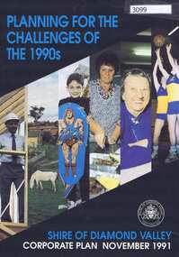
Pamphlet, Planning for the challenges of the 1990s: Shire of Diamond Valley Corporate Plan, 1991_11
Shire of Diamond Valley Corporate Plan 1991. Includes Shire map and statistics with plans for services to the community.16p. text and coloured photographsshire of diamond valley -
 Greensborough Historical Society
Article, Dawn Bennetts (nee Petts), Eltham Community Market, 1978o
A history of the Eltham Community Market by stallholder Dawn Bennetts. The Market began in 1978 and Dawn joined in 1985.7 typed pages, col. illus. and maps.eltham community market, dawn bennetts -
 Greensborough Historical Society
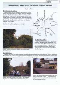
Article, Journal, Keith Patterson, The Paper Mill branch line on the Hurstbridge Railway, by Kevin Patterson, 2012_12
A branch line from the Outer Circle Line was built for the delivery of coal and paper pulp to the Australian Paper Mill at Fairfield. It operated as a branch from the Hurstbridge line until the 1970s, when the Australian Paper Mill plant changed to power by Bass Strait oil. 3 p., text , map and coloured photographs, pp. 4-6 of Nillumbik Custodian December (?) 2012husrstbridge railway line, outer circle railway line, australian paper mill -
 Greensborough Historical Society
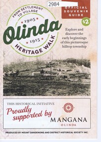
Pamphlet, Olinda Heritage Walk: official souvenir guide, by Mount Dandenong and District Historical Society Inc, 2016_
Walking guide to early Olinda buildings 1905-191524 p. pamphlet, map, photographs, with accompanying postcard from Patricia Hogan to Noel Withersolinda, mount dandenong -
 Greensborough Historical Society
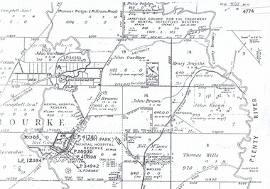
Maps, Greensborough west of Plenty River, 1840o
Areas of Greensborough, west of the Plenty River, showing land holdings in the 1840s. Comprises Sections 8, 9, 10, 14, 15, 16, 17, 18, 19, 20 Parish of KeelbundoraOne A4 photocopy, one A3 enlargementgreensborough, watsonia, lower plenty, janefield -
 Glenelg Shire Council Cultural Collection
Plan - Plan - early Portland, n.d
Early plan drawing of PortlandHand-drawn plan on paper, glued on linen backing. Plan shows layout of properties and a lagoon. Hand-tinted in colour. Names of property owners written on lots.plan, map, town, portland -
Glenelg Shire Council Cultural Collection
Programme - Program - Victorian Decentralisation League, MODERN PRINT WARRNAMBOOL, n.d
This league advocated for the creation of a new state encompassing Portland, Warrnambool, Camperdown and Mount Gambier.Program for the Annual Conference of the Victorian Decentralisation League at Portland September 14th and 15th 1948. Eight pages, black and white including photographs and mapsdecentralisation, programme, programme, annual conference, 1948, 1940s, post war -
 Glenelg Shire Council Cultural Collection
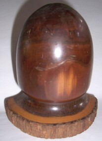
Functional object - Bookends, c. 1930
Two bookends made of mulga wood. Shaped in curved arch shape on semi-circular base. Bark still attached to curve of base. Varnished.Front: Underneath - Mulga wood/Abo brand (sticker, gold map Aust. Lacquered over) -
Glenelg Shire Council Cultural Collection
Programme - Programme - Upwelling Festival, 2012, c. 2012
Programme for Upwelling Festival 3rd November 2012, at Portland. Presented by Rotary Club of Portland Bay Inc. White, blue and green motifs and print, folds out, information one side, map with programme and location of events/displays on the other.marine ecology, upwelling festival, whales -
Glenelg Shire Council Cultural Collection
Administrative record - Cashbook - Ancient Order of Foresters, c. 1878
Cash book, hard cover, green marbled, brown leather binding. Members' contributions and expenses for Court The Hope (Portland), dating from 9 March 1878 - 24 Nov 1914 White label on cover '1878 - 1914'Back: inside back cover - small sketch map of the site of Foresters' Hall in Portland - black ink on white paper -
Glenelg Shire Council Cultural Collection
Pamphlet, Portland Holiday Centre of the South West, 1970s
Trifold pamphlet 'Portland Holiday Centre of the South West'. Coloured photos, map, tours and information. -
Glenelg Shire Council Cultural Collection
Book, THE CAMBRIDGE HISTORICAL READERS, c. 1914
Hard back, olive black print and outline of tower spires. 'British History text, black and white photographs and maps -
 Glenelg Shire Council Cultural Collection
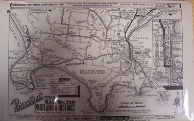
Map - Map - "Broadbent's Map of Portland and District, no. 28", n.d
... Cliff Street Portland great-ocean-road Unknown Map Map ...Unknown -
Glenelg Shire Council Cultural Collection
Map - Map- Tarragal, n.d
... Cliff Street Portland great-ocean-road Map - Tarragal ...Map - Tarragal - No further information supplied -
Glenelg Shire Council Cultural Collection
Map, 1885
Significant collection relating to the social history across the shire.Map, Victoria. Skeleton map of Telegraph Circuits and Railways 1885. Scale 16 miles to 1 inch.map, skeleton map, telegraph, railways, 1885, 1880s -
Glenelg Shire Council Cultural Collection
Decorative object - Badge - Fish Holes Rally 1987, Portland, Victoria, c. 1987
Fish Holes Rally badge, 1987. cream enamel and gold coloured badge. Image of motor bike superimposed on outline map of Victoria, 'Portland' marked on map. 'FISH HOLES RALLY' around top curve of badge. '1987' in gold frame bottom curve of badge. Eyelet each side of badge. -
Glenelg Shire Council Cultural Collection
Postcard - Postcard - Portland, Victoria, c. 2000
Contemporary postcard of Portland. 4 full colour images of Cape Bridgewater. 'Portland Victoria, Australia' - in white, on blue bottom margin. Travellers notes logo on right. Reverse: title of images, map of Australia with Melbourne indicated and Portland region by rectangle. -
Glenelg Shire Council Cultural Collection
Souvenir - Stamp Pack - Australian Shipwrecks, May-07
Set of 3 Australian stamps depicting shipwrecks- Admella (50c face value) in presentation and Dunbar ( $2 face value) in presentation folder showing map of Southern Australia. -
Glenelg Shire Council Cultural Collection
Souvenir - Limited Edition 1st Day Cover - Historic Shipwrecks - Admella 150 - 2009, c. 2009
Limited edition first day cover. Buff coloured envelope with map of southern Victoria, 50 cents Admella stamp, Post marked with first day issue Admella commemorative pictorial Postmarker, 6 August 2009. Also Admella 150th logo, 'Historic Shipwrecks' on front. Back to short history of shipwrecks, Admella, Loch Ard, and dunbar and 5 cents butterfly stamp. -
Glenelg Shire Council Cultural Collection
Souvenir - Limited Editions First Day Covers - Historic Shipwrecks - Admella 150 2009, 2009
Limited edition first day cover. Both coloured envelope, with map Southern Victoria. 50 cents Admella Stamp not cancelled. 'Admella 150th Logo, 'Historic Shipwrecks' on front. back, short history of shipwrecks, Admella Lock Ard, Dunbar. -
Glenelg Shire Council Cultural Collection
Postcard - Postcard - Portland, Victoria, n.d
Contemporary postcard of Portland. Full colour, 9 images of Portland 'Portland Victoria, Australia" in white, bottom edge, left. 'Traveller's notes logo - right. Reverse has descriptions of 9 images, outline map of Australia showing Melbourne and rectangle of Portland area. -
Glenelg Shire Council Cultural Collection
Booklet - Booklet - Historic Portland Street Names Victoria, c. 1972
Sixteen page booklet, grey card cover, red and blue print, Historic Portland street Names, their location, origin and significance. Yellow pages, black print, street map affixed to inside back cover -
Glenelg Shire Council Cultural Collection
Book, Illustrated Bible Geography and Atlas, n.d
religion; atlas; geography; Bible; Judah; Israel;Book, 'Illustrated Bible Geography and Atlas'. red card covers, white banner with red print. Map of Judah and Israel in white on front cover. 32 pages on geography of the Bible; 16 pages of coloured maps, most in biblical times; 8 black and white photos of Jerusalem.religion; atlas; geography; Bible; Judah; Israel; -
Glenelg Shire Council Cultural Collection
Book, E.N.T. HENRY, Historic Portland Street Names, 1972
Book of historic Portland street names, including their origin, location and significance. A street map of Portland is attached to inside of back cover. Semi gloss card covers, grey with red and blue print. Inside pages pale yellow, black print. Map of Portland white with black print.local history, street names, portland, directory -
Glenelg Shire Council Cultural Collection
Book - Book - Simple Studies in British History, William Gillies M. A, n.d
Hardback, brown, black print. British History textbook, black and white photos, map of world first pages, British Empire shown in red. -
Glenelg Shire Council Cultural Collection
Book - Book - Stories in British History Part 1, William Gillies, n.d
Hardback, red, black print. British History text book covering the period 55 BC to 1558 AD. Black and white maps and illustrations -
Glenelg Shire Council Cultural Collection
Book, M.M. CRAWFORD, Ourselves and the Pacific, c. 1943
Hardback green, blue print, history of nations bordering Pacific Ocean, black and white maps. Front endpaper, trade and population map, green and whte back endpaper, topographical map of the Pacific, green and whitehistory, pacific, geography -
Glenelg Shire Council Cultural Collection
Book, The British Empire with its World Setting, c. 1916
history; British Empire; world historyHardback, red with black print and line drawing world map, front cover, British Empire in solid black. Junior geography textbook with black and white mapshistory; British Empire; world history -
Glenelg Shire Council Cultural Collection
Booklet, c. 1965
Part of a booklet on Portland, 'The Gateway of Opportunity' c 1965. Pages not numbered, so it's unclear whether it is only the front cover missing. Back cover - map of Portland hinterland -
Glenelg Shire Council Cultural Collection
Map - Map - Portland, 1950s
... Cliff Street Portland great-ocean-road map Portland Portland ...White card with 2 maps of Portland; larger one showing the town and harbour, smaller one of town, Portland Bay, Bridgewater Bay, Nelson Bay, Lawrence Rocks. Also Portland phone numbers: Ambulance Hospital, Police, Fire, Taxi, Electricianmap, portland, portland harbour, cape bridgewater, south west coastline