Showing 10763 items
matching site
-
 Glenelg Shire Council Cultural Collection
Photograph - Photograph - Blacknose Quarry, 29/08/1952
Port of Portland Authority ArchivesFront: 'BLACKNOSE QUARRY SITE 29 AUG 1952 SHOWING AREA STRIPPED OF OVERBURDEN' - printed in bottom frame Back: Purple PHT stampport of portland archives, blacknose quarry -
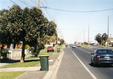
 Sunbury Family History and Heritage Society Inc.
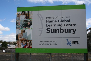
Photograph, Rosa McCall, 2018
After the former Sunbury Library was demolished sign was erected in front of the site in 2018 to inform the public that the new library was going to be erected on that site.Work commenced on the new library in 2018.A coloured print of a digital photograph of a sign placed in front of a building site.sunbury library, macedon street, libraries -
 Kilmore Historical Society
Photograph, 91 Sydney Street
15cm x 10cm coloured photograph of the cutting at 91 Sydney Street, Melbourne Street at the top of the cutting. Now is the site of the car wash and KFC. Written on the back: Liz Dillon-Hensby against the cutting on 91 Sydney Street (Missen fleet site) last July 2016construction -
Glenelg Shire Council Cultural Collection
Photograph - Photograph - Main Breakwater construction, Portland, n.d
Port of Portland Authority Archivesport of portland archives, construction, site, work site, harbour, portland, battery point, crane -
 Whitehorse Historical Society Inc.
Document, Melbourne Theatres, 2013
A4 document of Melbourne Theatre Site Legendpayne john a, theatres -
 Whitehorse Historical Society Inc.
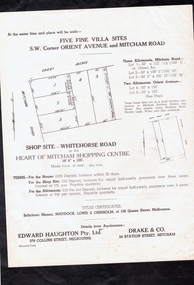
Document, 296 Mitcham Road, Mitcham, 1941
Auction leaflet of a new brick veneer house at 296 Mitcham Road, Mitcham.Auction leaflet of a new brick veneer house at 296 Mitcham Road, Mitcham along with 5 villa sites and a shop site by auctioneers Edward Haughton Pty Ltd and Drake & Co. on 5 Jul 1941.Auction leaflet of a new brick veneer house at 296 Mitcham Road, Mitcham. mitcham road, mitcham no. 296, orient avenue, whitehorse road, mitcham, drake co., edward haughton pty ltd -
Whitehorse Historical Society Inc.
Article, Disability farm in limbo, 2013
Doubts have bee raised about the suitability of an alternative site for the NADRASCA farm which is part of the Healesville Freeway Reservation at Morack Road.Doubts have bee raised about the suitability of an alternative site for the NADRASCA farm which is part of the Healesville Freeway Reservation at Morack Road. The site suggested is near Morack Golf Course.Doubts have bee raised about the suitability of an alternative site for the NADRASCA farm which is part of the Healesville Freeway Reservation at Morack Road. nadrasca, healesville freeway reservation, morack road vermont, koedyk, gus, leane, shaun, morack golf course -
 Orbost & District Historical Society
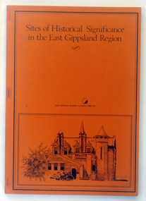
Booklet - book, Booklet, softcover, Sites of Historical Significance in the East Gippsland Region, October 1980
This is the second report by the East Gippsland Regional Planning Committees part of the Regional Studied Program in East Gippsland requested by Mrs Marion Le Cheminant.This is a useful reference tool. It documents sites of significance, including the Orbost area of East Gippsland.A stapled book with a brown/orange cover. On the front cover is a black print hand-drawn illustration of some buildings (possibly Bairnsdale Courthouse. The title, "Sites of Historical Significance in the East Gippsland Region", is in black print at the top. This is inside a black border.Sites of Historical Significance / in the East Gippsland Region / EAST GISPPSLAND REGIONAL PLANNING COMMITTEEhistoric sites, history, east gippsland, heritage -
 Queenscliffe Maritime Museum
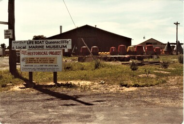
Photograph - QMM site selection 1984, Colour Photograph
Colour photos of the original site selected for the Queenscliffe Maritime MuseumSite selectionColour photos of the original site selected for the Queenscliffe Maritime MuseumReverse - NILcommunity information, queenscliffe maritime museum -
 Lakes Entrance Historical Society
Photograph - McCrae's Lime Kiln, 1999
Site of lime burning operations from 1870's. Lime burnt for agricultural purposes. Cocky Roberts was using lime in his glass making business at Lakes Tyers.Colour photograph of the McCrae Lime Kiln site east side shows work site now encroached on by bushland. Toorloo Arm Victoriahistoric site, local history -
 Falls Creek Historical Society
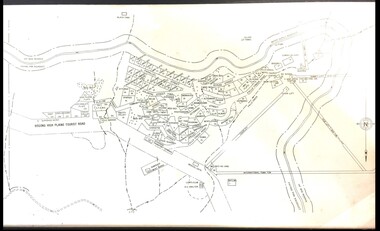
Map - Falls Creek mid 1970s
A site map produced for the Falls Creek Tourist Area Management CommitteeThis map is significant because it documents an important stage in the development of Falls Creek, Victoria.A framed and mounted site map of Falls Creek mid 1970sfalls creek tourist area management committee, falls creek tourist area, falls creek 1970s -
 Hume City Civic Collection
Photograph, early 1990's
The set of 20 photographs were taken of a number of archaeological sites in Sunbury of sacred sites and aboriginal rings. The photographs were included in a study of these sites which was published by the Shire of Bulla in the early 1990's.Site of an Aboriginal Ring near Sunbury. It is situated on a cleared mound with small hills across the skyline.aboriginal ring sites, george evans collection -
Whitehorse Historical Society Inc.
Article, Green Designs Test the Best
.The Burwood East brickworks site.The Burwood East brickworks site. This site was at the centre of a global design competition to create the world's greenest retail centre with a prize of $30,000 won by the entrant Difference is Living..The Burwood East brickworks site. brickworks, burwood east -
 RMIT Design Archives
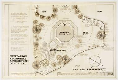
Work on paper - Architectural drawings, Aboriginal Keeping Place, Shepparton International Village
Site plan drawing of the Shepparton Aboriginal Arts Council building, now known as the Bangerang Cultural Centre. The building is located in the Parkside Gardens, formerly the Shepparton International Village, and is the first Aboriginal cultural museum developed and managed by the Aboriginal community. The building is part of the Victorian Heritage Register. Romberg designed the building in conjunction with project instigator and Bangerang Elder, John Sandy Atkinson, OAM. At the request of Romberg, Atkinson created some concept sketches for the building from which Romberg designed the finished structure.Site PlanInitialed in grey pencil, bottom right: 'F.R'architecture, museum -
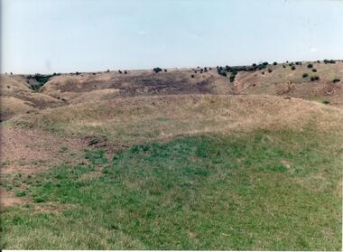
 Hume City Civic Collection
Photograph, early 1990's
The 20 photographs were taken of a number of archaeological sites in Sunbury of sacred sites and aboriginal rings. The photographs were included in a study of these sites which was published by the Shire of Bulla in the early 1990's.A view of Aboriginal Ring Site near Rupertswood. The country is undulating with trees in the middle distance and the ring in the foreground.aboriginal ring sites, george evans collection -
 Sunbury Family History and Heritage Society Inc.
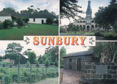
Postcard, John Munns, Sunbury, C1980s
The four sites featured on the postcard are: Top row L-R Emu Bottom Homestead and Rupertswood Mansion. Bottom row L-R Goonawarra Vineyard and Aitkens Gap Gaol. George Evans built Emu Bottom and William Clarke was the first owner of Rupertswood. Goonwarra was one of Sunbury's early vineyards and the gaol was relocated on the police station from its original site at The Gap village on the Calder Highway.The four sites featured are important historic places in SunburyA coloured postcard featuring four historic sites in Sunbury. The word 'SUNBURY' is printed in orange across the centre of the card. Details of the four sites, the photographer and the postcard company are on the back.emu bottom, rupertswood mansion, goonawarra winery, aitkens gap gaol, george evans, william j.t. clarke -
 Ballarat Tramway Museum
Photograph - Colour Print/s, Warren Doubleday, 14/09/2003 12:00:00 AM
Colour photograph of Albert St. Sebastopol at the site of the Grey St Loop, looking south. Shows the road layout in 2003. Photo taken by Warren Doubleday on 14/09/2003. Printed on Agfa paper. On rear of each photo in brown felt tip pen, the words "Grey St. Loop site" and "14/9/02".albert st, grey st loop -
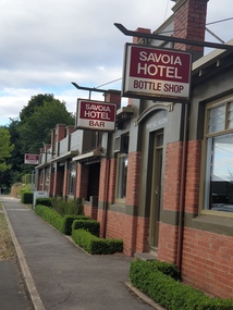 Ballarat Heritage Services
Photograph, Clare Gervasoni, Savoia Hotel, Hepburn Springs, 25/02/2021
Now known as the Savoia Hotel, the original Savoia House was present behind a new brick front until refurbishments in 2022.Colour photograph of Savoia Hotel, Main Road, Hepburn Springs. The hotel is an important site for the Swiss/Italian Community."A focal point for Italian speakers; in 1857 the site included Lorenzo's blackmsiht, Faustino's show shop, Sr Rosetti's Union Store and Giovanettina's Lemonade Store." Swiss & Italian Festa Committee 2012savoia hotel, spring creek hotel, hotels, hepburn springs -
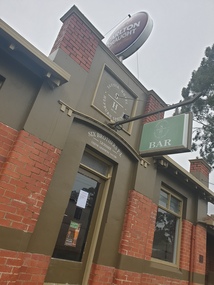 Ballarat Heritage Services
Photograph, Clare Gervasoni, Savoia Hotel, Hepburn Springs, 06/2023
Now known as the Savoia Hotel, the original Savoia House was present behind a new brick front until refurbishments in 2022.Colour photograph of Savoia Hotel, Main Road, Hepburn Springs. The hotel is an important site for the Swiss/Italian Community."A focal point for Italian speakers; in 1857 the site included Lorenzo's blackmsiht, Faustino's show shop, Sr Rosetti's Union Store and Giovanettina's Lemonade Store." Swiss & Italian Festa Committee 2012savoia hotel, spring creek hotel, hotels, hepburn springs -
 Hume City Civic Collection
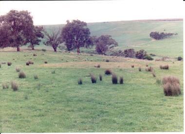
Photograph, 1990-1999
A number of photographs were taken to record the various aboriginal sites around Sunbury.View of one of the aboriginal sites in Sunbury. The sky is grey and the hillside are golden brown.sunbury, aborigines, sacred sites, george evans collection -
 Marysville & District Historical Society
Document (Item) - Receipt, Larry and Margaret Richmond, 2000
A receipt for a deposit paid for an unpowered site at the Marysville Caravan Park that was issued in 2000.A receipt for a deposit paid for an unpowered site at the Marysville Caravan Park that was issued in 2000.marysville, victoria, australia, marysville caravan park, accommodation, receipt -
Whitehorse Historical Society Inc.
Article, Unanimous Support for Brickworks
Whitehorse Council wants to fast-track a 950 home development .Whitehorse Council wants to fast-track a 950 home development for the former Burwood Brickworks site.Whitehorse Council wants to fast-track a 950 home development . brickworks, brick and pipe industries ltd, australand -
Whitehorse Historical Society Inc.
Map, Blackburn Heights Estate, 1923
Auction plans of sub-division for Blackburn heights Estate.Auction plans of sub-division for Blackburn heights Estate, 130 sites, 8th December 1923Auction plans of sub-division for Blackburn heights Estate.springfield road blackburn north, surrey road blackburn north, gordon street blackburn north, koonung road blackburn north, harris street blackburn north, hirst street blackburn north, deane street blackburn north, blackburn heights estate, blackburn north -
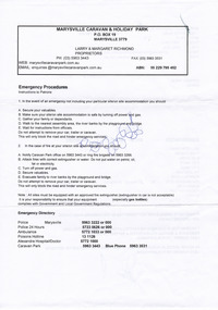
 Warrnambool and District Historical Society Inc.
Document, Voting paper Cattle Yards 1883, 1883
This voting card was to determine the site of the new cattle yards in Warrnambool. The choice was between a Raglan Parade site (the present Swan Reserve Children’s Services centre and an Allansford Road site east of the Old Bryen Boiroimhe Hotel (Corner of japan Street and Raglan Parade. The Raglan Parade site at the corner of Kepler Street was the preferred site polling 373 to 222. These saleyards were moved to the present site in Caramut Road in 1970. Portions of the old stone walls around the Raglan Parade / Kepler Street site can still be seen.This document has local interest particularly as the site of the Warrnambool saleyards is still a matter of some discussion.White paper with black text Town of Warrnambool in Capital letters at top of document. The document reads Determination of site for cattle yards. Wednesday February 7th 1883. The back has small sticker W22cattle yards warrnambool, warrnambool, warrnambool saleyards -
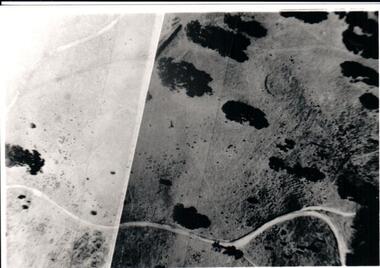 Hume City Civic Collection
Photograph, Late 1980s
A study was conducted to locate a number of Aboriginal sites in Sunbury in the 1980s. This study took place as a result of the expanding development on Sunbury's outskirts.A black and white aerial view of one of the Aboriginal ring sites in Sunburyaboriginal sites, aboriginal rings, george evans collection -
 Port Melbourne Historical & Preservation Society
Photograph - J Kitchen & Sons perimeter survey, Woodruff Street, Dec 2013
As the former j Kitchen & Sons site was being cleared, Lionel Layfield, who had worked at the site for many years undertook several pictorial perimeter surveys. These photos were taken in Dec 2013.Series 1 of colour photographs taken by Lionel Layfield as he walked around the perimeter of the J Kitchen & Sons Pty Ltd factory site during the early demolition of most of the buildings. .31-.36 - looking into the factory site from Woodruff Streetindustry - manufacturing, built environment - industrial, business and traders - soaps/candles, j kitchen & sons pty ltd, symex holdings ltd, north port oval, port melbourne cricket and football oval -
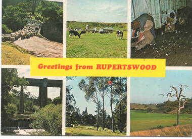 Sunbury Family History and Heritage Society Inc.
Postcard, Murfett Publishers, 'Rupertswood', C1970s
The post card waas assembled by Salesian College, which is in Rupertswood Mansion. The six images are sites within the Rupertswood Estate and are as follows: Clockwise from L-R- Sheep at the Bridge crossing at Jacksons Creek, Friesan Stud sale, Shearing sheep, Jackson Creek flats, Rupertswood Mansion, Railway bridge spanning Jacksons Creek. Initially Salesian College started as an agricultural school training boys in farm skills. It is now a co-educational secondary college.A postcard with six non-digital photographs of sites within the Rupertswood Estate. Information about each site and the manufacturer's details are on the back of the card.Across the centre of the postcard: GREETINGS FROM RUPERTSWOODrupertswood mansion, salesian college, railway viaduct, jacksons creek, sheep shearing, friesan cattle, sunbury -
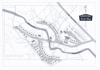 Marysville & District Historical Society
Map (Item) - Marysville Caravan Park map, Marysville CARAVAN PARK-Park Map, Unknown
A map of the Marysville Caravan Park showing the location of the various sites and facilities available to guests.A map of the Marysville Caravan Park showing the location of the various sites and facilities available to guests.marysville, victoria, australia, marysville caravan park, map -
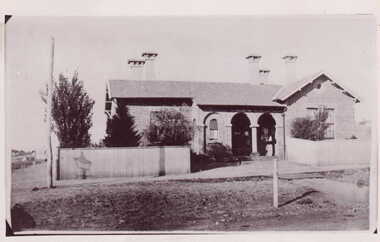 Clunes Museum
Photograph
PHOTOGRAPH COPIED FROM EARLIER PHOTOGRAPH BY MR. E J SEMMENS. FIRST STAGE OF POST OFFICE - SINGLE STORY BUILDING WITH FIVE CHIMNEYS, SECTIONS OF BUILDING BUILT WITH SMALL BRICKS. GALVANISED IRON FENCE.BLACK AND WHITE PHOTOGRAPH CLUNES POST OFFICE ON SITE OF FORMER POST OFFICE. SINGLE STORIED BUILDING WITH GALVANISED FENCING.On back of photo handwritten in pencil "Clunes" "Clunes Post Office on present site of Post Office" "Copied 30/5/48 EJS" Sticker with "P.D.C 810" handwritten in pencil "20/6" handwritten in pencillocal history, photography, photographs, post office -
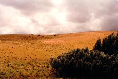
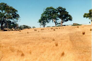 Hume City Civic Collection
Photograph, c late 1990s
The series of 9 photographs were taken to be included in a study of archaeological sites and Aboriginal rings in the Sunbury area. Five earth rings which are thought to be associated with male initiation ceremonies have been identified in Sunbury. Only 3 others have been found in the rest of Victoria. Despite rapid development in the area, those sites are protected heritage sites.A coloured photograph of an open hillside which is a sacred site. Gum trees and grassy tufts are dotted across the hillside.aboriginal culture, aboriginal rings, sacred sites, george evans collection