Showing 1235 items matching "the gap"
-
 Flagstaff Hill Maritime Museum and Village
Equipment - Gauze & Box, Flexlock Products, Early - Mid 20th Century
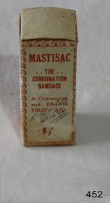
When used as a medical dressing, woven gauze is usually made of cotton. It is especially useful for dressing wounds where other fabrics might stick to the burn or laceration. Many modern medical gauzes are covered with a perforated plastic film such as Telfa or a polyblend which prevents direct contact and further minimizes wound adhesion. Also, it can be impregnated with a thick, creamy mixture of zinc oxide and calamine to promote healing, as in Unna's boot. (An Unna’s boot is a special gauze (usually 4 inches wide and 10 yards long) bandage, which can be used for the treatment of venous stasis ulcers and other venous insufficiencies of the leg. It can also be used as a supportive bandage for sprains and strains of the foot, ankle and lower leg. The gauze is impregnated with a thick, creamy mixture of zinc oxide and calamine to promote healing. It may also contain acacia, glycerin, castor oil and white petrolatum.) Gauze is also used during procedures involving accidental tooth loss; either the gauze is used to provide pressure as the tooth is moved back into its corresponding socket, or the tooth is wrapped in gauze and placed in milk or saline to keep it alive while the tooth is being transported or prepared for reinsertion. https://en.wikipedia.org/wiki/GauzeAccess to emergency medical help in early settlement days of Victoria could take quite some time, especially in remote areas. From 1888 First Aid Kits and instructions became available for work sites, offices, community groups and individuals, helping to bridge the gap between the accident and the arrival of medical assistance. Gauze was widely used in many medical conditions.Gauze and box entitled "MASTISAC?. The Combination Bandage" Bandage is complete with instructions for use inside.Mastisac ‘The combination Bandage. A convenient and effective FIRST AID. Prepared and distributed by Flexlock products, 15 Mills Street, Albert Parkflagstaff hill, warrnambool, shipwrecked-coast, flagstaff-hill, flagstaff-hill-maritime-museum, maritime-museum, shipwreck-coast, flagstaff-hill-maritime-village, first aid, bandages, dressings, medical -
 Kiewa Valley Historical Society
Wilkinson Lodge - copies of 6 photos, 1 plaque, 1 article
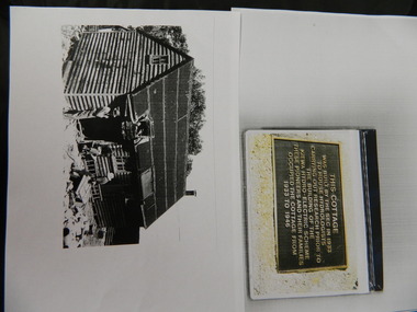
Wilkinson's Hut was built for the State Electricity Commission of Victoria in 1932 as a permanent residence for the snow research program manager, who was the resident engineer of the Kiewa Hydro Electric Scheme. The hut was sold in 1948 to the Ski Club of Victoria / Victorian Alpine Club and renamed Wilkinson Lodge. In 1958 it was sold to the Melbourne Bushwalkers Club. It was burnt down on 17th January 2004.Wilkinson Lodge was located at Wallace Gap on the Bogong High Plains and was the first S.E.C.V. permanent residence for the workers of the Kiewa Hydro Electric Scheme. It is also an early built lodge owned briefly 1946 - 1958 by the Ski Club of Victoria / Victorian Alpine Club and used by skiers before other lodges were built at Falls Creek. It was used by bushwalkers until it was burnt down thus in itself depicting part of the history of the area.5 pages of copies of photos of Wilkinson Lodge, 1 page of a copy of the destruction of Wilkinson Lodge (6 small photos), 1 page of a copy of a plaque titled 'This cottage' and 1 page of an article from the Border Mail (newspaper) dated 19th Jan. 2004.wilkinson hut; secv; ski club of victoria; melbourne bushwalkers club; fire -
 Kiewa Valley Historical Society
Necklace Silver Lover's Knot, circa late 1800's
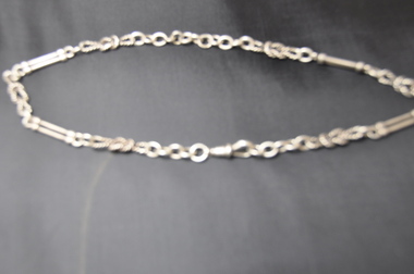
This "lovers" necklace is made from Sterling Silver and was imported into "the Colony" before the Australian Federation was enacted. This was a time when very close "bondage" between Australia and England was shown by the amount of "quality" products that were purchased, and the motto "Best of British" was truly still entwined in all aspects of rural live, from "British" mores and values "inherited from the "colonial days". It was only after World War II (when Britain could not help to defend Australia from the Japanese) that these long held mores were, through generations and generations, that the USA and Asian markets and goods replaced the "old" ties.This ladies silver necklace is very significant to the Kiewa Valley because it demonstrates the "rural" mores and values at a time(1800's to mid 1900's) when the "gap" between city and rural mores was very pronounced. That gap was maintain only through the degree of "isolation" (communication and physical interactions) between the two major types of "communities" and the evolving mores which each of them were going through. The social structure was just as pronounced in rural areas as it was in the cities. Fine jewelry was a "sparkling" affirmation of status and "wealth". The rural sectors had very wealthy sectors before the World Wars, when "Australia" was riding "on the sheep's back", but the increased mineral wealth exports and "big" industry of the cities started to forge ahead.This necklace is made from sterling silver and has four double bar and six lover's knots coupled to a silver chain. There is one silver double bar missing and may have been removed to reduce the length of the necklace. Sterling silver Hallmarks and Makers marks are stamped on the links and the clasp. The meaning of the horizontal twin bars have not yet been interpreted .Hall marks "PWC" and "AA"necklace, jewellery, sterling silver, lovers knot -
 Kiewa Valley Historical Society
Postcard Circa 1950, Snow Plough, Bogong High Plain,5,500 Feet Kiewa Hydro-Electric Project, Circa 1950
This postcard was produced in the 1950's for the tourist trade in the Kiewa Valley and Alpine region. It encompasses the period when the State of Victoria was pressured by the ever increasing demand by industry and its population for electricity supplies. Hydro electricity was seen as an untapped natural resource to quench this demand. The Victorian Alps and the rivers flowing into its valleys was ideal for the construction of the Kiewa Hydro Electricity Scheme. The late 1940's saw the development of this scheme and the changing of sections of alpine landscape is covered by this and other postcards/pictures (tourists, construction workers, and established rural populations). This period in time was before the established wildlife and forest/nature groups became political activist who changed legislative acts to protect the environment. This rural region (Kiewa Valley/alpine plains) was at most only significant to a smaller group of winter sports, summer hikers/horse riders and rural farmers/graziers. The numbers of tourists and the increase in the local resident population was boosted by the construction of the Hydro Electricity Scheme. This influx to the regional population resulted in a corresponding diversity in services and brought about an environment that responded to a growing level of tourists and thereby permitting this industry to grow more rapidly than it would have naturally. This postcard details an attraction to the "cleaner" method of providing electricity. This postcard was purchased in 1950 by a surveyor at Landford's Gap. This item is a black and white photograph(professional) of a panoramic view of a snow plough clearing the unsealed road in 1950.This postcard is on quality paper and the reproduction of the picture is of a high standard.For other "tourist" postcards see 0480 (A) -(F) for other photos of similar postcards. kiewa valley tourism, victorian alps, alternate energy supplies, alpine population growth, secv, snow plough -
 Kiewa Valley Historical Society
Postcard Circa 1950, Road to Bogong High Plains Kiewa Hydro Electric Project, Circa 1950's
This postcard was produced in the 1950's for the tourist trade in the Kiewa Valley and Alpine region. It encompasses the period when the State of Victoria was pressured by the ever increasing demand by industry and its population for electricity supplies. Hydro electricity was seen as an untapped natural resource to quench this demand. The Victorian Alps and the rivers flowing into its valleys was ideal for the construction of the Kiewa Hydro Electricity Scheme. The late 1940's saw the development of this scheme and the changing of sections of alpine landscape is covered by this and other postcards/pictures (tourists, construction workers, and established rural populations). This period in time was before the established wildlife and forest/nature groups became political activist who changed legislative acts to protect the environment.This rural region (Kiewa Valley/alpine plains) was at most only significant to a smaller group of winter sports, summer hikers/horse riders and rural farmers/graziers. The numbers of tourists and the increase in the local resident population was boosted by the construction of the Hydro Electricity Scheme. This influx to the regional population resulted in a corresponding diversity in services and brought about an environment that responded to a growing level of tourists and thereby permitting this industry to grow more rapidly than it would have naturally. This postcard details an attraction to the "cleaner" method of providing electricity. This postcard was purchased in 1950 by a surveyor at Landford's Gap.This black and white photograph on a Valentine's postcard is from a V2 Argus photograph.. It is on a 200g/m paper density photo side gloss. See 0480 (A) - (G) for other photos of similar postcards.In white lettering " ROAD TO BOGONG HIGH PLAINS KIEWA HYDRO-ELECTRIC PROJECT", V3secv, road making, victorian alps -
 Kiewa Valley Historical Society
Postcard - Rocky Valley - Circa 1950, 1950
This postcard was produced in the 1950's for the tourist trade in the Kiewa Valley and Alpine region. It encompasses the period when the State of Victoria was pressured by the ever increasing demand by industry and its population for electricity supplies. Hydro electricity was seen as an untapped natural resource to quench this demand. The Victorian Alps and the rivers flowing into its valleys was ideal for the construction of the Kiewa Hydro Electricity Scheme. The late 1940's saw the development of this scheme and the changing of sections of alpine landscape is covered by this and other postcards/pictures (tourists, construction workers, and established rural populations). This period in time was before the established wildlife and forest/nature groups became political activist who changed legislative acts to protect the environment.This rural region (Kiewa Valley/alpine plains) was at most only significant to a smaller group of winter sports, summer hikers/horse riders and rural farmers/graziers. The numbers of tourists and the increase in the local resident population was boosted by the construction of the Hydro Electricity Scheme. This influx to the regional population resulted in a corresponding diversity in services and brought about an environment that responded to a growing level of tourists and thereby permitting this industry to grow more rapidly than it would have naturally. This postcard details an attraction to the "cleaner" method of providing electricity. This postcard was purchased in 1950 by a surveyor at Landford's Gap.This black and white photograph is from a Valentine's V2 Argus postcard. It is on a 200g/m paper density one side gloss. See also KVHS 0480 (A) to (L) for similar postcards. "ROCKY VALLEY FROM BOGONG HIGH PLAINS KIEWA HYDRO-ELECTRIC PROJECT" "V1"kiewa valley tourism, victorian alps, alternate energy supplies, alpine population growth, rocky valley, secv -
 Kiewa Valley Historical Society
Postcard - Junction Dam - Circa 1950, Circa 1950's
This postcard was produced in the 1950's for the tourist trade in the Kiewa Valley and Alpine region. It encompasses the period when the State of Victoria was pressured by the ever increasing demand by industry and its population for electricity supplies. Hydro electricity was seen as an untapped natural resource to quench this demand. The Victorian Alps and the rivers flowing into its valleys was ideal for the construction of the Kiewa Hydro Electricity Scheme. The late 1940's saw the development of this scheme and the changing of sections of alpine landscape is covered by this and other postcards/pictures (tourists, construction workers, and established rural populations). This period in time was before the established wildlife and forest/nature groups became political activist who changed legislative acts to protect the environment.This rural region (Kiewa Valley/alpine plains) was at most only significant to a smaller group of winter sports, summer hikers/horse riders and rural farmers/graziers. The numbers of tourists and the increase in the local resident population was boosted by the construction of the Hydro Electricity Scheme. This influx to the regional population resulted in a corresponding diversity in services and brought about an environment that responded to a growing level of tourists and thereby permitting this industry to grow more rapidly than it would have naturally. This postcard details an attraction to the "cleaner" method of providing electricity. This postcard was purchased in 1950 by a surveyor at Landford's Gap.This black and white photograph is a Valentine's postcard, from a V2 Argus photograph. It is on a 200g/m paper density with only the photo side gloss.Front "JUNCTION DAM & SPILLWAY, BOGONG KIEWA HYDRO-ELECTRIC PROJECT" on the flip side "VALENTINE'S POST CARD " "A GENUINE PHOTOGRAPH"kiewa valley tourism, victorian alps, alternate energy supplies, alpine population growth, junction dam, secv -
 Kiewa Valley Historical Society
Postcard - Junction Dam - Circa 1950, Circa 1950
This postcard was produced in the 1950's for the tourist trade in the Kiewa Valley and Alpine region. It encompasses the period when the State of Victoria was pressured by the ever increasing demand by industry and its population for electricity supplies. Hydro electricity was seen as an untapped natural resource to quench this demand. The Victorian Alps and the rivers flowing into its valleys was ideal for the construction of the Kiewa Hydro Electricity Scheme. The late 1940's saw the development of this scheme and the changing of sections of alpine landscape is covered by this and other postcards/pictures (tourists, construction workers, and established rural populations). This period in time was before the established wildlife and forest/nature groups became political activist who changed legislative acts to protect the environment.This rural region (Kiewa Valley/alpine plains) was at most only significant to a smaller group of winter sports, summer hikers/horse riders and rural farmers/graziers. The numbers of tourists and the increase in the local resident population was boosted by the construction of the Hydro Electricity Scheme. This influx to the regional population resulted in a corresponding diversity in services and brought about an environment that responded to a growing level of tourists and thereby permitting this industry to grow more rapidly than it would have naturally. This postcard details an attraction to the "cleaner" method of providing electricity. This postcard was purchased in 1950 by a surveyor at Landford's Gap.This black and white photograph on a Valentine's postcard is from a V2 Argus photograph. It is on a 200g/m paper density one side gloss only/. See 0480 (A) -(L) for other photos of similar postcards."JUNCTION DAM & SPILLWAY, LAKE GUY, BOGONG, KIEWA HYDRO-ELECTRIC PROJECT" "V5" on the flip side" VALENTINE'S POST CARD " "A GENUINE PHOTOGRAPH"kiewa valley tourism, victorian alps, alternate energy supplies, alpine population growth, junction dam, secv -
 Kiewa Valley Historical Society
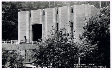
Postcard Circa 1950, No.3 Power Station Kiewa Hydro-electric Project "V.8", Circa 1950
This postcard was produced in the 1950's for the tourist trade in the Kiewa Valley and Alpine region. It encompasses the period when the State of Victoria was pressured by the ever increasing demand by industry and its population for electricity supplies. Hydro electricity was seen as an untapped natural resource to quench this demand. The Victorian Alps and the rivers flowing into its valleys was ideal for the construction of the Kiewa Hydro Electricity Scheme. The late 1940's saw the development of this scheme and the changing of sections of alpine landscape is covered by this and other postcards/pictures (tourists, construction workers, and established rural populations). This period in time was before the established wildlife and forest/nature groups became political activist who changed legislative acts to protect the environment.This rural region (Kiewa Valley/alpine plains) was at most only significant to a smaller group of winter sports, summer hikers/horse riders and rural farmers/graziers. The numbers of tourists and the increase in the local resident population was boosted by the construction of the Hydro Electricity Scheme. This influx to the regional population resulted in a corresponding diversity in services and brought about an environment that responded to a growing level of tourists and thereby permitting this industry to grow more rapidly than it would have naturally. This postcard details an attraction to the "cleaner" method of providing electricity. This postcard was purchased in 1950 by a surveyor at Landford's Gap.This black and white photograph from a Valentine's postcard is from a V2 Argus photograph postcard. It is on a 200g/m paper density photo side gloss. See 0480 (A) - (K) for other photos of similar postcards."No.3 POWER STATION KIEWA HYDRO ELECTRIC PROJECT" "V8"kiewa valley tourism, victorian alps, alternate energy supplies, alpine population growth, secv -
 Kiewa Valley Historical Society
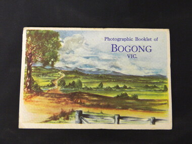
Booklet - Bogong, Photographic Booklet of Bogong Vic
This booklet was produced to advertise Bogong Village and surrounding areas. The photos depict the area's buildings and equipment being used at the time. Bogong Village housed the State Electricity Commission of Victoria's employees working on the Kiewa Hydro Electric Scheme which began in the 1930's and finished in the 1960's. Maisie describes her visit in May 1958 giving an insight into the area including the weather and the roads.The photos indicate what the area around Bogong looked like c1958 towards the end of construction but before the bush grew back after the 1939 fires at Bogong village and after construction of the shopping centre at Mt Beauty. A sno' cat and snow plough are also shown emphasising the change in machinery over the years. This enables comparisons to be made in many areas of study.A fold down booklet postcard size of 9 black and white photos of Bogong village and surrounds and a letter addressed to Mrs. A. Parnell of Sydney from Maisie. Maise's husband has 2 married sisters living near Bogong on farms. The booklet is in a clear plastic sleevePostage stamp arrived in Sydney 28th May 1958.bogong. lake guy. howman gap hostel. mt beauty.bogong high plains. -
 Kiewa Valley Historical Society
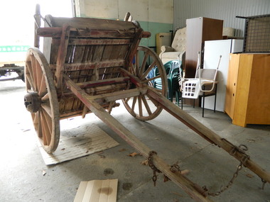
Tipping Dray
The dray was pulled by a horse and used to transport road building materials such as gravel. The tray carried 0.7 of a cubic metre which would have weighed about 1 tonne (varying on the load being wet or dry).This tipping dray was owned by John Briggs who carried gravel on the Tawonga to German Creek Road from 1894 to 1895. Workers were paid 2/- (shillings) per day to cover sections that were called 'a paddock' resulting in workers finishing at 10 or 11 pm. The road opened on the 17th March 1896 at a cost of 1700 pounds. See KVHS 0960 for newspaper article re Tom Briggs and making (and photo) of the Tawonga Gap road.Old single axil wooden dray with wooden spoke wheels and a tipping wooden tray.tipping dray. john briggs. tawonga. german creek. road building. transport. -
 Waverley RSL Sub Branch
Minefield Warning Flag
German Luftwaffe (Land Forces) minefield warning flag from WWII.originally intended to be gas markers, rather than mines, but as it turned out, the use changed .they were mounted on a red metal pole & there were 12 to a set in a leather pack. This Flag was presented to the Treasurer of Waverley RSL. It is a souvenir from Bardia in Libya The Battle of Bardia was fought over three days between 3 and 5 January 1941, as part of Operation Compass, the first military operation of the Western Desert Campaign of the Second World War. It was the first battle of the war in which an Australian Army formation took part, the first to be commanded by an Australian general and the first to be planned by an Australian staff. Major General Iven Mackay's 6th Division assaulted the strongly held Italian fortress of Bardia, Libya, assisted by air support and naval gunfire, and under the cover of an artillery barrage. The 16th Infantry Brigade attacked at dawn from the west, where the defences were known to be weak. Sappers blew gaps in the barbed wire with Bangalore torpedoes and filled in and broke down the sides of the anti-tank ditch with picks and shovels. This allowed the infantry and 23 Matilda II tanks of the 7th Royal Tank Regiment to enter the fortress and capture all their objectives, along with 8,000 prisoners. In the second phase of the operation, the 17th Infantry Brigade exploited the breach made in the perimeter, and pressed south as far as a secondary line of defences known as the Switch Line. On the second day, the 16th Infantry Brigade captured the township of Bardia, cutting the fortress in two. Thousands of prisoners were taken, and the Italian garrison now held out only in the northern and southernmost parts of the fortress. On the third day, the 19th Infantry Brigade advanced south from Bardia, supported by artillery and the Matilda tanks, now reduced in number to just six. Its advance allowed the 17th Infantry Brigade to make progress as well, and the two brigades reduced the southern sector of the fortress. Meanwhile, the Italian garrisons in the north surrendered to the 16th Infantry Brigade and the Support Group of the British 7th Armoured Division outside the fortress. In all, some 36,000 Italian prisoners were taken. The victory at Bardia enabled the Allied forces to continue the advance into Libya and ultimately capture almost all of Cyrenaica. In turn this would lead to German intervention in the fighting in North Africa, changing the nature of the war in that theatre. Bardia boosted the competence and reputation of the Australian Army. Perhaps most important of all, it raised confidence in the possibility of an ultimate Allied victory around the world, which would lead to the Lend-Lease Act being passed in the United States http://en.wikipedia.org/wiki/Battle_of_BardiaCloth Flag bearing a skull and cross Bones on a metal spike mounted on a square varnished wooden basebardia, land mine, marker flag, minefield, mustard gas -
 Lara RSL Sub Branch
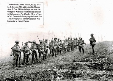
Photo, The Battle of Amiens,France,8Aug,1918
The Battle of Amiens, also known as the Third Battle of Picardy (French: 3ème Bataille de Picardie), was the opening phase of the Allied offensive which began on 8 August 1918, later known as the Hundred Days Offensive, that ultimately led to the end of the First World War.By the end of August 8—dubbed “the black day of the German army” by Ludendorff—the Allies had penetrated German lines around the Somme with a gap some 15 miles long. Of the 27, 000 German casualties on August 8, an unprecedented proportion—12,000—had surrendered to the enemy. Though the Allies at Amiens failed to continue their impressive success in the days following August 8, the damage had been done.Rectangular shaped black and white photograph.The battle of Amiens,France,8thAug.1918.Lt R Downes MC.addressing his Platoon from B Coy.29 BN.during a rest near the village of Warfusee before the advance on to Harbonnieres.Pte Charles Olive of Lara is 3rd,from the left carrying the Lewis Gun. He was killed in action three weeks later charging a German machine gun post. Earlier in the day, he had successfully taken two machine gun posts. Photo from Australian War Memorial, Canberra.ww1, battle of amiens, australian army, lara r.s.l. pte charles olive., awm accession no e2790 -
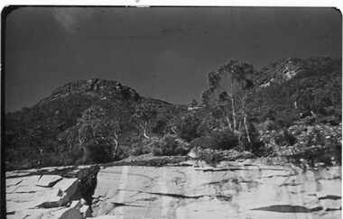
 Halls Gap & Grampians Historical Society
Photograph - B/W
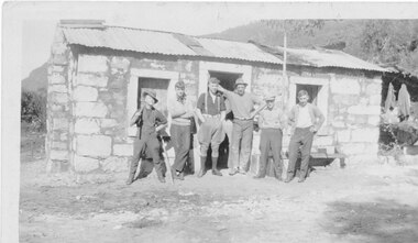
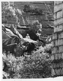
It is believed that the three stone cottages in the area were built c.1930 by Italian stonemasons. This cottage is a single room with open fireplace at one end. A hole was dug in the floor inside which a small drum was sunk and covered by a wooden lid. It served as a cool box for the storage of perishable food. It is not known when the cottage was last occupied but during the 1970s the drum was removed and the pit filled in for safety reasons. Photo shows 6 men standing in front of stone cottage at Heatherlie (Mt Difficult) quarry. Cottage made from sawnand off-cuts of stone with stone window frames and door lintel. Rough bush-pole awning at right hand end of cottage.houses, mt difficult quarry -
 Halls Gap & Grampians Historical Society
Photograph - B/W, C 1960s (?)
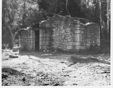
Heatherlie quarryHeatherlie Quarry - Photo shows Stone-mason's cottage in a state of disrepair and before renovations. Building has no roofquarrying, mt difficult quarry -
 Halls Gap & Grampians Historical Society
Photograph - B/W, C 1960s (?)
Heatherlie QuarryStone-mason's hut Heatherlie Quarry - Photo shows Stone-mason's cottage in a state of disrepair and before renovations. Building has no roofquarrying, mt difficult quarry -
 Halls Gap & Grampians Historical Society
Photograph - B/W, C 1960s (?)
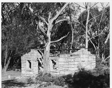
Heatherlie quarryStone-mason's hut Heatherlie Quarry - Photo shows Stone-mason's cottage in state of disrepair and before renovations. Building has no roof; gumtree stands in centre foreground quarrying, mt difficult quarry -
 Halls Gap & Grampians Historical Society
Photograph - B/W, C 1955
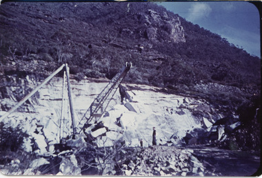
This copy b/w - other 2 copies catalogued separately (both coloured) Heatherlie quarry Heatherlie quarry - Photo shows 2 people standing in quarry. Machinery; in foreground; rock-face middle distancequarrying, mt difficult quarry -
 Halls Gap & Grampians Historical Society
Photograph - Coloured, 1955
Heatherlie QuarryHeatherlie Quarry - Photo shows 2 people standing in quarry. Machinery in foreground; rock-face middle distancequarrying, mt difficult quarry -
 Halls Gap & Grampians Historical Society
Photograph - Coloured, 1955
Heatherlie QuarryHeatherlie Quarry - Photo shows 2 people standing in quarry. Machinery in foreground. Rock-face middle distancequarrying, rocklyn -
 Halls Gap & Grampians Historical Society
Photograph - B/W, C 1900s
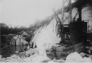
Heatherlie quarry - Photo shows a large piece of equipment front right. Three men & a woman standing in front of rock wall. Pool of water middle leftquarrying, mt difficult quarry -
 Halls Gap & Grampians Historical Society
Photograph - B/W, C 1882
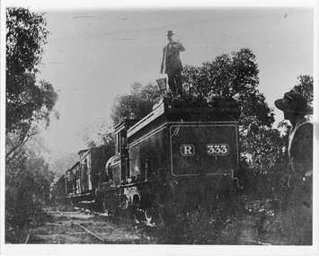
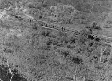
Occasional picnic trains took large groups of visitors to the base of the mountain range & sometimes as far as the quarry. Other journeys terminated at Fyans Creek station on the south side of Mt Dryden. Most trips were Sunday School & Church outings, some on the annual Good Friday picnic. Spring was also a popular timePhoto shows train at siding. Man standing on engine roof with bucket in hand; woman in right hand corner of photo looking on; passenger looking out of open doorway. R333 written on back of engine car. Engine turned back to fronttransport, trains -
 Halls Gap & Grampians Historical Society
Photograph - B/W, C 1882
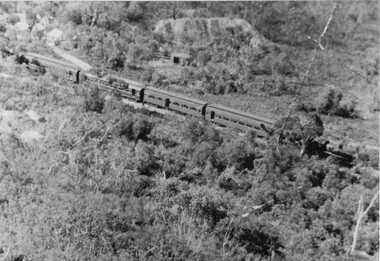
Heatherlie Quarry - Photo shows passenger train leaving Heatherlie (engine at front). Tents top-left corner. Stables(?) middle background. misc industries, bee-keeping -
 Halls Gap & Grampians Historical Society
Photograph - B/W, C 1882�
Heatherlie Quarry Picnic train - Photo shows passenger train leaving Heatherlie (engine at front). Tents top left corner. Stables(?) from John Payne - Willaura copied from a friend from ? ? (words indecipherable) - written on back of phototransport, trains -
 Halls Gap & Grampians Historical Society
Photograph - B/W, C 1902
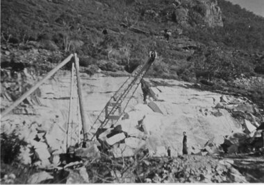
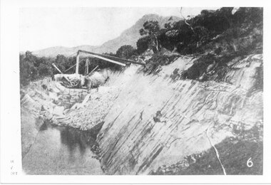
Heatherlie Quarry. . Shows equipment working rock-face with pool of water in foreground'From the Weekly Times, September 1902" written on backquarrying, mt difficult quarry -
 Halls Gap & Grampians Historical Society
Newspaper - B/W, C 1899
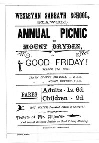
Picnic poster advertising Annual Picnic Mount Dryden Good Friday March 31st 1899media, flyers -
 Halls Gap & Grampians Historical Society
Photograph - B/W
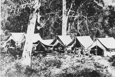
Railway survey camp 1880 After choosing the route, the rail survey was undertaken followed by the construction of the line in less than a year. By Nov 1881 access by rail for Heatherlie to Melbourne was a reality Railway survey camp Heatherlie quarry; 11 men, some standing, some reclining in front of 6 army style tentsstructures, tents -
 Halls Gap & Grampians Historical Society
Photograph - Coloured, 1955
Part of rockface at Heatherlie Quarryquarrying, mt difficult quarry -
 Halls Gap & Grampians Historical Society
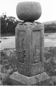
Photograph - B/W, 1866
Watkins created his sculpture for an exhibition in Melbourne 1866: "I dressed the pillar about 2 foot 6 inches high and 16 inches square and proceeded to carve in each panel representation characteristic of Victoria 1st Panel a Kangaroo in a small scrub thicket, 2nd an Emu amongst a clump of little flowering correa; 3rd the Wimmera Down and on the 4th side my name and the date AD 1866 On the top of the pillar was an urn of globular form to represent the seed pod of the Eucalypti with spreading leaves underneath" Extract taken from 'Victoria's Wonderland' a Grampians history Monument now in private handsHeatherlie Quarry; Obelisk : Photo shows stone monument created by Francis Watkins using materials from quarry Photo shows two sided view of monument with large stone on topquarrying, mt difficult quarry -
 Halls Gap & Grampians Historical Society
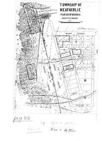
Map - Photocopy
Photocopy of map of Heatherlie TownshipTownship of Heatherlie; Parish of Boroka; County of Borung; scale measurement; R.O. Robson Authorised Surveyormaps, heatherlie township