Showing 11430 items
matching maps
-
 Glenelg Shire Council Cultural Collection
Pamphlet - Brochure - Glenelg River Canoeing Guide, Oct-88
Glenelg River canoeing guide, 4 pages, single-fold. Front and back pages information, photos and images of various areas of the Glenelg River; inside pages - detailed map of river and landings/camp sites. -
Glenelg Shire Council Cultural Collection
Document - Portland Tourism Brochure, National Parks Victoria, n.d
DL flyer, fold out map showing location of National Parks in Victoria with written description of each, plus photos of various flora and fauna, prefaced by brief history of national parks in Victoria. Full colour. -
Glenelg Shire Council Cultural Collection
Map - Map - Paper Survey, n.d
Paper survey map, ink and watercolour, framed under glass. Painted black gloss. Shows Fawthrop lagoon and surrounds including Fawthrop's home 'Windsor Cottage', outbuildings and garden, Cairncross and Howard holdings and othersBack: 'Town of Portland' -
 Geelong RSL Sub Branch
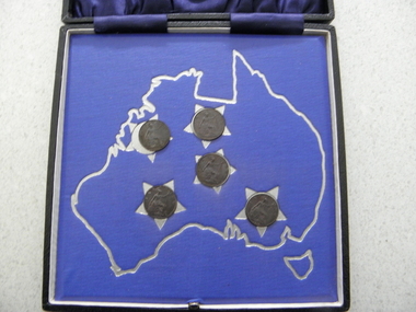
Coins - ANZC Commemoration 1926, There are no makers marks, 1926
This coin set was issued in the memory of 6800 A E Kemp who served with the AIF during WW1 and was killed in action on 21 September 1917 at Glencorse Wood.This coin set is an original that was issued by the family of 6800 A E Kemp to commemorate ANZAC 1926.Square black leather display box with the lid lined in blue satin, the base has a map of Australia with the southern cross outlined on a cardboard inlay, there are five (5) 1914 Farthings on each star of the southern cross.One the cover of the box - ANZAC Commemoration 1926. -
 Kiewa Valley Historical Society
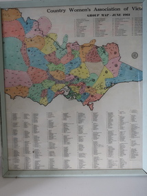
Framed Map - CWA- Tawonga
CWA of Victoria was a popular widely known organisation throughout Australia. The CWA aimed to improve health welfare, and education for women and children living in the country.Each town / area in the Kiewa Valley had an active CWA. The Tawonga branch commenced in Feb. 1946 and often combined activities with other branches of the Kiewa Valley.Country Women's Association of Victoria Group Map, June 1961. each area is colored ad each wit a letter of the alphabet. each group has a number and is listed. eg. blue, 'N' and "Tawonga 14' country women's association, map of cwa groups, tawonga cwa -
 Ringwood and District Historical Society
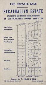
Flyer, Land Sale Advertisement - Strathallyn Estate, Ringwood, Victoria - circa 1950
Advertisement for private sale of 36 home sites in the Warrandyte Road and Mullum Mullum Road area of Ringwood, with map showing layout of subdivision and summary of local features and services. Handwritten notation indicates May, 1950.Subdivision includes Warrandyte Road, Strathallyn Road, Norman Court, Lade Court, and Mullum Mullum Road. Agents: A.T. Miles & Son, 175 Main Street, Ringwood, Phone WU6215. -
 Orbost & District Historical Society
survey sheet, circa 1870's
E.L. Bruce, born in Ireland on July 1,1854, came to Australia in 1854 and joined the Lands Department. He spent most of his service in Gippsland. The journey to Sale then was made by ship to Port Albert and thence on horseback. He began his service in Gippsland as assistant district surveyor and for the last 12 years before retirement he was district surveyor and land officer. His territory extended from the boundary of Victoria in east Gippsland down to Wilson's Promontory with his headquarters at sale.This map is a useful reference tool.A survey map - Sheet No 3 SnowyRiver Survey. This is a copy of the original survey. It shows the properties of W.J.T. Clarke - two in Orbost and one in Newmeralla (sic),. it has a faded, undecipherable red stamp in the bottom right corner.Gipps Land Rivers No 32B E.L. Brucesurvey bruce-e.l snowy-river-c19th -
 Federation University Historical Collection
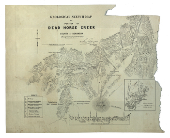
Map, Dead Horse Creek, 1887, 29/05/1887
Geological sketch map of a portion of Dead Horse Creek. WGS 84 Centroid Lat: 36 degrees 50 inches S Long: 148 degrees 00 inches S NS: 4.3km EW 4.8kmdead horse creek, james stirling, gold, geology, mount cobberas -
 Federation University Historical Collection
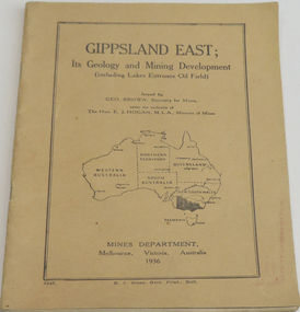
Book, Gippsland east: its geology & mining development, 1936
Soft brown covered book of 45 pages about East Gippsland mining and development. Includes map of Gippsland East, Lakes Entrance. Includes Lakes Entrance, Metung, Beng Worden, Bairnsdale, Longford, Torquay.gippsland east, gippsland, geology, mining, mines department, geo. brown, e.j. hogan -
 Ringwood and District Historical Society
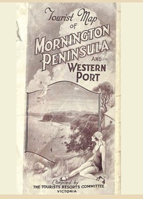
Memorabilia, Tourist Map of Mornington Peninsula and Western Port - 1929
Multi-fold pictorial map of towns, railways and main roads east of Port Phillip Bay from Melbourne to Yarra Junction and south to Phillip Island and Wonthaggi, backed by details of main features and points of interest.Photo-Lithographed by Department of Lands and Survey, Melbourne, 2.8.1929. -
 Ringwood and District Historical Society
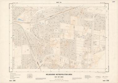
Map - Melbourne Metropolitan Area Base Map Series, Sheet 236 - Ringwood area, 1961
Map prepared by Dept of Lands and Survey and MMBW from State Aerial Survey June 1957 and Cadastral Survey information May 1961. This sheet comprises parts of the Municipalities of Croydon and Ringwood, and Parishes of Ringwood and Warrandyte.Scale: 400 feet to 1 inch. Contours at 5 feet vertical interval. By Authority: A.C. Brooks, Commonwealth Printer, Melbourne. -
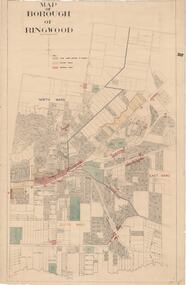 Ringwood and District Historical Society
Map, Borough of Ringwood, Victoria - c.1950s
A0-size (approx) map of named streets and lot-numbered properties within Borough of Ringwood ward boundaries. Colour-coded key marking Land Under Control of Council, Factory Areas, and Business Areas.Scale: 8 chains to 1 inch. North Ward, East Ward, South Ward. -
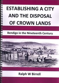 Bendigo Historical Society Inc.
Book - ESTABLISHING A CITY AND THE DISPOSAL OF CROWN LANDS
Establishing a city and the disposal of Crown lands, Bendigo in the Nineteenth century, 153 pages with maps,illustrations, black & white and some coloured photographs. Spring bound with plastic cover. Published and printed by Bendigo Historical Society.Ralph W Birrellbendigo, history, land sales -
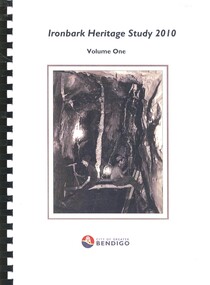 Bendigo Historical Society Inc.
Book - IRONBARK HERITAGE STUDY
Ironbark Heritage Study 2010 Volume One & Two, contains maps and photographs of houses in area along with heritage reports and historical information. Prepared by Amanda Jean Architect and Heritage consultant for the City of Greater Bendigo.Amanda Jeanbendigo, buildings, heritage buildings -
Bendigo Historical Society Inc.
Book - A HISTORY OF THE SAINT KILIAN'S CHURCHES, BENDIGO FROM 1852 TO THE PRESENT, 1998
A History of the Saint Kilian's Churches Bendigo, from 1852 to the present. Includes, churches on the St. Kilian's site, slab and canvas church, the pro- cathedral, weatherboard church. 6 pages with colour illustrations, maps. With Indexchurch, history, st. kilian's catholic church, bendi, st. kilian's, history of church, church, renovation of church. -
Bendigo Historical Society Inc.
Book - BENDIGO SUB-REGIONAL STRATEGY PLAN 1980
141 page soft cover spiral bound booklet 'Bendigo Sub-Regional Strategy Plan - September 1980' Areas covered , City of Bendigo, Borough of Eaglehawk, Shires of Huntly, Marong and Strathfieldsaye. Maps included.Bendigo Sub-Regional Committee -
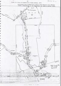 Bendigo Historical Society Inc.
Document - DIAMOND HILL STATE SCHOOL SITE
Map (copy) showing the site of Diamond Hill State School, 1873. On top of page 'extracted from Diamond Hill Public Park Reserve File RS8128, drawn and reproduced at the Department of Lands and Survey, Melbourne'bendigo, education, diamond hill state school -
 Bendigo Historical Society Inc.
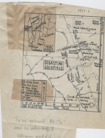
Negative - TOM PATULLO COLLECTION: SEBASTIAN GOLDFIELD
Negative,/Hand drawn of the goldfield featuring gold mine sites,cyanide vats,heaps,railway station,sports ground. A small map of the Whipstick area, and legend. Tom Patullo was formerly of Clear-Ads Bendigo.cottage, miners, sebastian goldfield, sebastian goldfield -
 Bendigo Historical Society Inc.
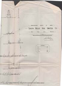
Map - STRUGNELL COLLECTION: UNDERGROUND SURVEY OF MINES, BENDIGO, 29-3-01
Map, Underground Survey of Mines, Bendigo, South Belle Vue United Co.,New Chum Line.Transverse Section. Signed H.S.Whitelaw29.3.01 Drawing appears to show samples of connecting horizontal shafts with their respective mineral contentsH.S.Whitelawmap, bendigo, south belle vue united co.. -
Port Melbourne Historical & Preservation Society
Flyer, Suggested ring road around Port, 2018 - 2019
These items were collected by a PMHPS member during 2018-19 and they have been retained as a group of ephemeraVarious ephemera of local interest showing changes in community. . Flyer regarding proposed ring road around Port Melbourne. Map of proposed route and listing key contact people. Campaign by Social Media Realty.built environment, ring road, social media ready -
Port Melbourne Historical & Preservation Society
Plan - Sandridge, Department of Lands and Survey, "The Township of Sandridge", 5 Nov 1860
Map of Sandridge, lithographed 1860, showing subdivisions on Evans Street, but no other development West of the railway Lihographed at the Department of lands and Survey, Melbourne 5th November 1860. Hand drawn annotations added at unknown date.Hand written "clay ground" 18 chains long, 7.5 chains broad, 26 chains from railwayengineering - roads streets lanes and footpaths, sandridge lagoon, transport - railways, town planning, local government - borough of sandridge -
Port Melbourne Historical & Preservation Society
Book, Phyllis Albinson Kelly, "Port Melbourne's Child - Memories of early years in Pickles Street", Oct 2005
"Port Melbourne"s Child - Memories of early years in Pickles Street" A5 book, 24 pages with 9 photos and map, by Phyllis Albinson Kelly. Yellow ochre cover Corrected (unsigned) second printingfamilies, built environment, education, war - world war ii, health - general health, phyllis albinson kelly, staples knights, dawsons emporium, our lady of mt carmel -
 National Vietnam Veterans Museum (NVVM)
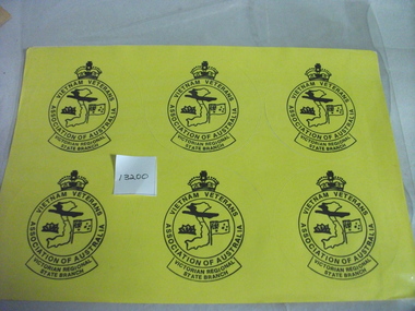
Memorabilia, Stickers
Twelve yello stickers (round) with black printing. Circle with crown at top. Vietnam Veterans Association of Australia,Victorian Regional State Branch. Vietnam map in centre with Anzac Badge and Australian Flag either side.stickers, vietnam veterans association of vic -
Tatura Irrigation & Wartime Camps Museum
file, State Rivers & Water Supply Commission
This collection was owned by Keith Daniel, an accountant with SR & WSC. Resident in Tatura 6-7 years until 1965File containing - Victorian Government Gazette March 6, 1968. - - Map, Goulburn Irrigation System - Murchison A, SR & WSC Journal "Aqua" April 1966 , Lake Eppalock Boating Guide, "Aqua Summer 1991, Brochure & newspaper adv. re: Waranga Lakeside estate.1974 -
Tatura Irrigation & Wartime Camps Museum
Tray - wooden, 1940
Made by internee at Camp 3 TaturaRectangular handmade wooden tray. Base has wood inlays feature map of Australia, kangaroo, emu, model of camp hut andd 4 internment camp coins. Also has hand printed working.Tatura Victoria Australien 1941-1944camp 3 wood crafts -
Tatura Irrigation & Wartime Camps Museum
Book, History of Waranga Basin, 1977
History of Waranga BasinSoft cardboard buff colour cover with brown printing. Map of Waranga Basins and surrounds in deeper colour. Details of Basin ie. depth and area etc. On back of cover photo of outlet and inlet of Waranga Basinhistory of waranga basin, hammond j, tatura, irrigation, books, history, local -
 Victorian Apiarists Association
Publication, 1st Australian Bee Congress, October 13-16, 1972
Just over A5 size soft cover book. Aqua cover with picture of Mugga Ironbark flowering on the front, colourful map of Australia on the back with honeycomb on it & surrounded by Australian birds on flowering gums 239 pagesThis volume was published under the guidance of - Prof. Dr. Eng. V Harnaj - President of Apimondia John Guilfoyle - President of the First Australian Bee congress Dr. Francis Smith - Editor of the scientific papers -
 Nillumbik Historical Society Incorporated
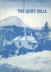
Book - Softcover book, Doreen Primary School, The Quiet Hills, 1983
A history in recollections and photographs of the Doreen district of Victoria, AustraliaCover is card 300gsm with painting converted to blue tones on front and back with white semi gloss paper pages 100gsm - 37 pages plus 3 page index and maps on inside of front and back coversnon-fictionA history in recollections and photographs of the Doreen district of Victoria, Australia -
 Whitehorse Historical Society Inc.
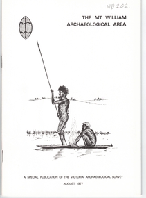
Document, Mt William Archaelogical Area, 1/08/1977 12:00:00 AM
Booklet issued by the Victorian Archaelogical Survey describing an abouiginal axe quarry at Mt William near Lancefield. The history of the site is described as is the archaelogical evidence.Booklet issued by the Victorian Archaelogical Survey describing an abouiginal axe quarry at Mt William near Lancefield. The history of the site is described as is the archaelogical evidence. A section describes the importance of axes in aboriginal culture. Map, illustrations.Booklet issued by the Victorian Archaelogical Survey describing an abouiginal axe quarry at Mt William near Lancefield. The history of the site is described as is the archaelogical evidence. aborigines, stone axes, mount william -
Whitehorse Historical Society Inc.
Pamphlet, Melbourne's water; a community problem, 1968
Collection of papers relating to Melbourne's future water needs by Leigh Blackburn with map extractsCollection of papers relating to Melbourne's future water needs by Leigh Blackburn with map extracts defining the area the author considers the most suitable for the development of future water resources and the dangers of the Lower Yarra Dam proposals.Collection of papers relating to Melbourne's future water needs by Leigh Blackburn with map extracts water supply, melbourne and metropolitan board of works, state rivers and water supply commission, lower yarra dam