Showing 11437 items
matching maps
-
 Bendigo Historical Society Inc.
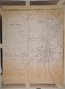
Map - CAMPBELL COLLECTION: BENDIGO AND DISTRICT MAPS
Map. South and West of Bendigo, Parish of Marong, Moonta, West Bendigo, Specimen Hill, Golden Square, Shire of Marong, Golden Gully, Kangaroo Flat, Diamond Hill, Shire of Strathfieldsaye, Crusoe, Parish of Lockwood.map, bendigo, parishes -
 Bendigo Military Museum
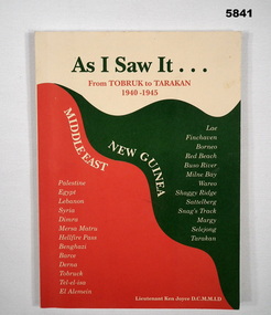
Book - AS I SAW IT, TOBRUK, Lieutenant Ken Joyce D.C.M., M.L.D
Owner and donor details. see Cat No. 5836.3. "As I saw it..." From Tobruk to Tarakan/ 1940-1945/ New Guinea/ Middle East" . "A short History of the 2/23rd Battalion " WW2.Soft cover book. Cover - cardboard, green, red and cream colour print on front cover with cream, green, red background. 88 pages - cut, plain, white. Illustrated black and white photographs and maps.books, military history, ww2, battalion history -
 Kiewa Valley Historical Society
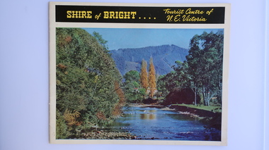
Brochure - Shire of Bright, Shire of Bright Tourist Centre of N.E. Victoria, Pre 1966
Bright and the surrounding towns were developing a large tourism industry which the Shire of Bright continues to promote, encouraging tourists to visit throughout the year. This high quality brochure has magnificent photos with a map showing the area and the distance (in miles) from the centre - the township of Bright.This brochure is promoting the Shire of Bright encouraging tourism in the area. This is important for the Shire as tourism is the main industry for the Shire. It is interesting to see how tourism has changed (or not) in the area.14 pages on glossy paper including colored and black and white photos. The front cover has the title at the top with yellow print on black background. Below the title is a large colored photo of a river, autumn trees and mountain. The back cover is a large colored photo of a man amongst the snow gums in the snow. The towns covered are Bright, Wandiligong, Eurobin, Mt Buffalo, McKay Creek Power Station, The Kiewa Hydro Electric Scheme, Mt Beauty, Kiewa, Bogong including tourist destinations in these areas and their surrounds.tourism; mt beauty; the kiewa valley; bright shire -
 Bendigo Military Museum
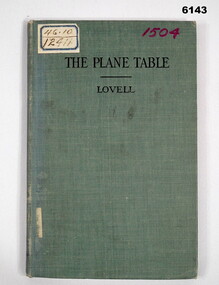
Manual - The Plane Table - Its Use in Surveying, McGraw Publishing Company, New York, USA, 1908
The plane table instrument was a simple but very effective early method of producing maps. Some very early editions were produced by the Australian Survey Corps after its formation in 1915 using this method. This manual details how to use the "Plane Table" for Surveying purposes.Hard Cloth covered Covers front and back, paper pages. title page has rubber stamp impressions (see below). Contents page, symbols page, pages 1-47 and index page.Adhesive label on front "46.10 and 12411", "1504" in purple also on front cover, Numbers inside front cover - "Acc. No. 000076" and crossed out. "scm - B0 - 86-72" written underneath. stamps- Australian Intelligence Corps, Headquarters library No 150 (difficult to read) on first page and stamped "CANCELLED" , Stamp School of Military Survey Library Call No 526 - 9825 LOV. Another stamp on title page - Department of Defence Library 46.10 and 12411. Second stamp 2/D. M.O.S. 2012 with CANCELLED. royal australian survey corps, rasvy, army survey regiment, army svy regt, asr, fortuna -
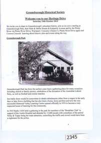 Greensborough Historical Society
Booklet, Greensborough Historical Society: Heritage Drive 2015, 24/10/2015
On Saturday 24th October 2015, the Greensborough Historical Society Heritage Day included a walk or drive to the Plenty River heritage precinct, observing many heritage sites in the area. This booklet was prepared by GHS President Noel Withers for those choosing to drive the route. A map is included.16 pages, text and images (some col.).greensborough historical society, plenty river pioneer trail, noel withers -
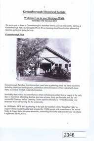 Greensborough Historical Society
Booklet, Greensborough Historical Society: Heritage Walk 2015, 24/10/2015
On Saturday 24th October 2015, the Greensborough Historical Society Heritage Day included a walk or drive to the Plenty River heritage precinct, observing many heritage sites in the area. This booklet was prepared by GHS President Noel Withers for those choosing to walk the route. A map is included.16 pages, text and images.greensborough historical society, plenty river pioneer trail, noel withers -
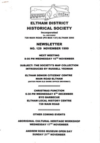 Eltham District Historical Society Inc
Newsletter, Newsletter, No. 129 November 1999
Contents: • Next meeting, The Society’s Map Collection; Introduced by Russell Yeoman • November Meeting • Christmas Function • Society Activities • Tarcoola Press • Museum Open Day • Aboriginal Cultural Heritage Workshop • The Shire of Eltham War memorial, Kangaroo Ground • Other News Items The Shire of Eltham Historical Society was formed in October 1967. The first newsletter of the Society was issued May 1978 and has been published continuously ever since on a bi-monthly basis. With the cessation of the Shire of Eltham in late 1994, the Society's name was revised to Eltham District Historical Society and this name first appeared with issue No. 103, July 1995. The collection of the Society's newsletters provides a valuable resource on the history of the Society's activities, office bearers and committee members, guest speakers and subjects of historical interest pertinent to the former Shire of Eltham and the Eltham District.A4 photocopied newsletter distributed to membersnewsletter, eltham district historical society, shire of eltham historical society -
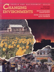 Surrey Hills Historical Society Collection
Book, Changing environments, 1990
There is a chapter dedicated to the physical and built environment of Surrey Hills and surrounding area. It includes maps drawn from the work of Alan Holt. The late Robyn Rivett (Rhodes) taught geography before becoming a curriculum adviser within the Education Department. She lived in Surrey Hills.Surrey Hills Neighbourhood Centre - historyhuman ecology, anthropo - geography, (mr) bruce tamango, people and environment series, streetscapes, (mrs) robyn rivett, (mrs) robyn rhodes, (mr) alan holt, surrey hills -
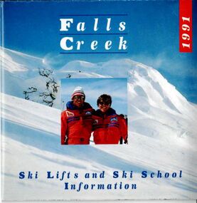 Falls Creek Historical Society
Booklet - Brochure - 1991 Falls Creek Ski Lifts and Ski School Information
Part of a yearly marketing and information material promoting Falls Creek ski region for the winter holidays. This is a small fold out guide to ski lifts, tariffs, ski runs and a map of Falls Creek. It also includes basic safety instructions and a promotion for the Frying Pan Inn.This item is important because it documents seasonal activities at Falls Creek Alpine ResortA small folded brochure promoting the Falls Creek Ski Lifts and Ski Schoolwinter sport, falls creek marketing, falls creek ski lifts -
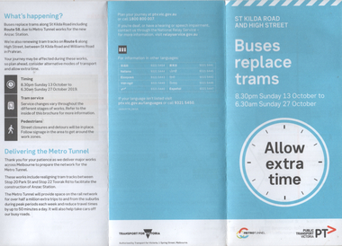 Melbourne Tram Museum
Pamphlet, Public Transport Victoria (PTV), "Buses replace trams - St Kilda Road and High Street", Oct. 2019
Pamphlet - "Buses replace trams - St Kilda Road and High Street" - part of the Metro tunnel project works, Oct 2019 affecting mainly route 6 trams along with St Kilda Road routes. Includes a map of the work zone and bus replacement services.Demonstrates a passenger information document about trackworks.Pamphlet - 6 fold DL printed trams, tramways, st kilda road, high st, route 16, metro tunnel, trackworks -
 Melbourne Tram Museum
Document - report, Norm Wadeson, "Sorrento Tramway", 1961
Notes prepared by Norm Wadeson 1961 from Lands Department Records about the history of the Sorrento Tramway. Has notes on the formation, operation, passengers carried, land, possible extension, deputations to the Minister, Mr George Copin, and closure. See item 7717 for maps and photographs.Yields information about the Sorrento tramway co. and its Lands Department records.Two quarto sheets, typed - stapled in top left hand corner.tramways, tramcars, sorrento, george coppin -
 Hume City Civic Collection
Manual - Directory, SUNBURY/INFORMATION/MANUAL
This Sunbury information manual of 1980-81has an index and lists the names, addresses and telephone numbers of residents and businesses. It also has a map with street index along with information regarding the council of the time. It has a list of Clubs & Societies operating at the time as well as other useful information.Yellow covered 72-page directory with a photo of Rupertswood Mansion on the front cover.SUNBURY/INFORMATION/MANUAL/6th Edition 1980-81sunbury, residents, businesses, 1980s, clubs, schools, doctors, shire of bulla, civic, george evans collection -
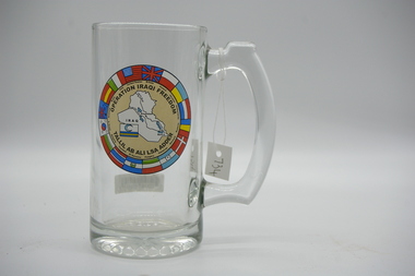 Lara RSL Sub Branch
Memento, Operation Iraqi Freedom Glass Tankard with handle
Historical remberance of OPERATION IRAQI FREEDOM.OPERATION IRAQI FREEDOMGlass Tankard "Operation Iraqi Freedom" with handle.On the front of the glass, it has a circular logo, outer ring has a combination of Flags of Nations involved in the conflict, the interior of the circle states OPERATION IRAQI FREEDOM - TILLIL AS ALI LSA ADDER, the center of the circle is a map of Iraq and a flag of Iraq.glass, operation iraqi freedom -
 Geelong RSL Sub Branch
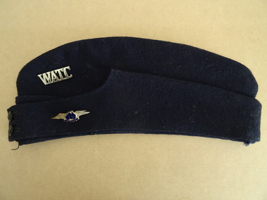
Forage Cap, mid 20th century
This cap belonged to a member of the Women's Air Training Corps. The Corps was established in 1939 in Brisbane. The Corps preceded the Women's Auxiliary Australian Air Force by 18 months.The Cap and Badges are originalsBlue Forage Cap, Photograph, Two BadgesInside the Cap - Imperial Cap Co Pty Ltd Size 6 7/3rd, Badge - WATC, Cap Badge - wings with Australian Map and initials WATC Black and white photograph 6x4. Initials R Sk inside the Cap.forage cap, watc -
 Ringwood and District Historical Society
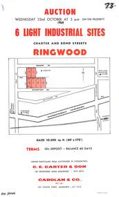
Flyer, Flyer advertising auction sale of light industrial sites in Ringwood, Victoria - 1969
Single page advertisement for auction sale of 6 light industrial sites in Charter Street and Bond Street in Ringwood on Wednesday 22nd October (1969).Advertisement includes terms of sale and location map. Auctioneers in Conjunction - C.E. Carter & Son, 126 Whitehorse Road Ringwood, (Telephone) 870 6024, and Carolan & Co. Pty. Ltd., 243 Collins Street, Melbourne, (Telephone) 63 7373. -
 Eltham District Historical Society Inc
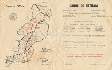
Document - Pamphlet, Shire of Eltham, December 1962
This pamphlet was issued for the information of ratepayers, with the compliments of the Eltham Shire Council. Subjects of information included: Shire statistics and history Members of Council 1962-63 Bushfires Dogs Rates Works Programme Shire Offices Town Planning Map of Shire of Eltham with Bushfire area outlined in redbushfires, charis pelling, charles m. a. pelling, councillors, dogs, eric dudley butler, eric percival harmer, franklin william nankervis, george l. cresp, leslie christopher docksey, m.b. watson, map, maxwell alexander spence, rates, raymond clive duncan, rodney d. quin, shire of eltham, shire offices, town planning, works programme -
Glen Eira Historical Society
Book - Murrumbeena State School No. 3449
This file contains a booklet celebrating Murrumbeena Primary School 75th Anniversary written and compiled by Brian Burgess. This book includes a written history with accompanying photos, maps and official papers, as well as lists of Principals, teachers and other staff, as well as personal recollections and a list of notable acknowledgements.murrumbeena primary school, william murray ross, oakleigh, caulfield times, celebrations, rosstown, certificate of title, brian burgess, carnegie, neerim road, mary scanlon (principal), hobart road., connie mc millan, caulfield, mary grant wilson, bert hunkler, malvern and caulfield gazette, mr. r. mcllroy, right reverend phillip newell – bishop of tasmania, robert spence, judith odger – evans, dora holmes, r. p. mclellan – director of primary education, dianne mierze jewski (nee greaves), head teachers/ principals, staff list -
 Bendigo Military Museum
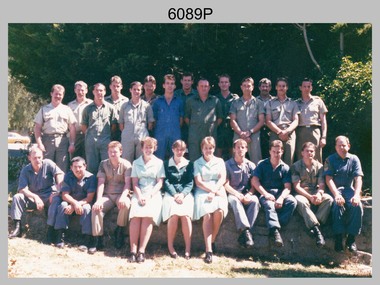
Photograph - Photo Troop, Lithographic Squadron - Army Survey Regiment, Bendigo, 1989
This is a photograph of Photo Troop, Lithographic Squadron; one of the Army Survey Regiment’s four squadrons, at Fortuna, Bendigo, December 1989. The main tasks undertaken by Photo Troop’s technicians were most likely photographic enlargements, reductions and duplication of map reproduction material, and processing of aerial photography.This is a photograph of Photo Troop Lithographic Squadron, Army Survey Regiment at Fortuna, Bendigo, 1989. The colour photograph was printed on photographic paper and is part of the Army Survey Regiment’s Collection. The photograph was scanned at 300 dpi. Back Row L to R: Rob Bogumil, Kevin ‘Chuck’ Berry, Andrew ‘Morrie’ Morrison-Evans, unidentified, Greg Howell, unidentified, Damien Cole, unidentified, Warren ‘Waldo’ Shirley, Steve Burke, Paul Baker, Bob Garritty, Frank Lenane, Bill Jones. Front Row L to R: John Bragg, Ken Peters, Gavin Craggs, Michelle Withers, Penny Knott, Di Chalmers, Geoff Webb, unidentified, Darren ‘Barney’ Maher, Kim Reynolds. No personnel are identified. Annotated on back with ‘Photo Troop Dec 1989’royal australian survey corps, rasvy, army survey regiment, army svy regt, fortuna, asr, litho -
 Greensborough Historical Society
Map, City of Heidelberg, Subdivision plan of Greensborough, 1965c
Subdivision plan of Greensborough including Briar Hill and Greenhills. Supplied by Bill Cecil whose parents owned the Greensborough Post Office and it is assumed that these maps were used by Bill (who delivered the post on horseback) to keep up to date with the growing number of new streets and housing in Greensborough.Copies of subdivision plan for Greensboroughgreensborough, briar hill, greenhills -
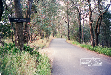 Eltham District Historical Society Inc
Photograph, Ardean Park, 315 Flat Rock Rd, Hurstbridge
Sold by Fletchers 3 Dec 2015 for $1.26m. See https://www.realestate.com.au/sold/property-house-vic-hurstbridge-121193850 Google Streetview Feb 2014 https://www.google.com.au/maps/@-37.6455525,145.2071828,3a,49.4y,333.82h,88.64t/data=!3m6!1e1!3m4!1sr2PfMo3UeXV_fqSDYToiuA!2e0!7i13312!8i6656Roll of 35mm colour negative film, 2 stripsKodak GA 100 5095shire of eltham, roads, flatrock road, hurstbridge, ardean park, cowan -
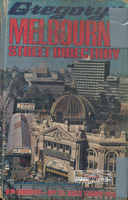 Eltham District Historical Society Inc
Book, Gregory's Melbourne Street Directory of Melbourne and suburbs and metropolitan road guide (8th edition) extends to Laverton, Deer Park, Epping, Diamond Creek, Lilydale, Olinda, Belgrave, Doveton and Mornington, 1973
This is the 8th edition of Gregory's Melbourne Street Directory, fully revised and up-to-date for this edition published December 1973. It is a comprehensive guide to the streets and localities of Melbourne and suburbs at that time. The colour maps are arranged in double-page spreads. Names of streets and suburbs are arranged alphabetically in the index to streets.Hard copy with plastic cover. 382 p. streets, melbourne - maps, roads -
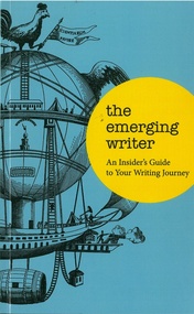 Emerging Writers' Festival
Book, The Emerging Writer
The Emerging Writer is an insider’s guide full of valuable advice from fellow travellers – a resource you can keep within arm’s length, for when you need to consult that map again to help you find your way. The book was published in 2012 and edited by Karen Pickering.A blue, yellow and black book with an image of a fanciful hot air balloon on the cover.emerging writers' festival, 2009, literary programming, the wheeler centre, the emerging writer, books, karen pickering, 2012, -
 Falls Creek Historical Society
Magazine - Falls Creek 1991 Winter Book
A part of a yearly marketing magazine promoting Falls Creek ski region for the winter holidays. It is a comprehensive directory of information related to Falls Creek activities, maps, accommodation, facilities, tariffs and packages, The back cover features a graph of Falls Creek Average snow base 1984 to 1990This item is important as it documents seasonal activities at Falls Creek Alpine ResortMagazine titled Falls Creek 1991 Winter book containing information and images for 1991 winter holidays.falls creek marketing, falls creek winter programs, falls creek accommodation, falls creek snow cover -
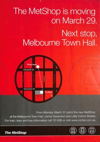 Melbourne Tram Museum
Poster, Metlink, "The Metshop is moving", 2008
Poster advising that the MetShop is moving from Elizabeth St to the Melbourne Town Hall on 31 March. It gives a map, has the Metlink logos on the bottom edge and a website address, which (2025) links to the PTV Website. Most likely based on the use of the Metlink logos and date - 2008.Demonstrates a Metlink poster, promoting The MetShop.Poster printed on heavy A3 size paper. melbourne, information, the met, metshop -
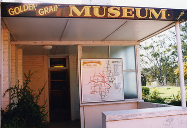 Charlton Golden Grains Museum Inc
Photograph, c.1990
Entrance to the Museum, showing a map of the area. Over the door in the sign "Golden Grain Museum". Formerly the Mechanics Institute which was built in 1882. The museum took over the building in 1973. The entrance exterior was built in 1950 as part of the Infant Welfare Centre which was in use until 1963. Standard colour photo."Golden Grain Museum"business, charlton, golden grains museum, mechanics institure -
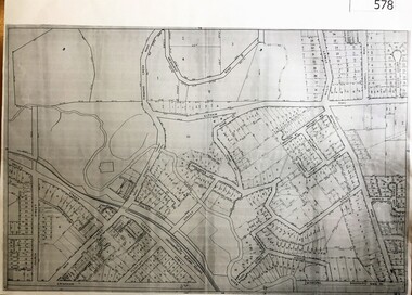
Whitehorse Historical Society Inc.
Map, Eastern Suburbs, 1922
... maps ...Enlargement of sections of 1922 Ringwood Commonwealth Survey - Imperial General Staff (West - Camberwell; North - Templestowe; East - Ringwood; South - Clayton)maps, nunawading, tunstall, box hill, blackburn, mitcham, vermont, burwood east, mont albert -
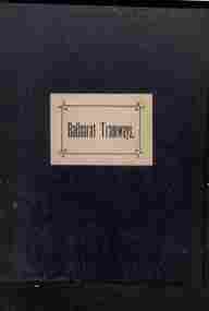 Ballarat Tramway Museum
Administrative record - Book, Andersons' printing, "Ballaarat Tramways", Jan. 1888
... maps ...Book with an index or table of contents, listing all the documents relating to the establishment of the Ballaarat Tramways (the horse tram operator) including, references to Legislation and orders in council, original tender conditions, the contract between the Council and Edward Thomson, Specifications for the construction, delegation to the operator, and plan of routes. Last document dated 17/1/1888.Yields information about the establishment of the Ballarat horse trams, Councils and the operator.Bound book, with end papers, 20 pages, patterned covers, titled with a label on the front cover - "Ballaarat Tramways"Has an old ownership note on the inside front cover.secv, tramways, horse trams, city of ballaarat, ballaarat tramway company, tenders, specifications, operations, maps -
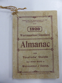
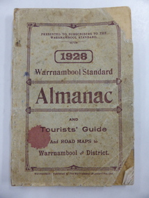 Warrnambool and District Historical Society Inc.
Book, Warrnambool Standard Almanac 1928, 1928
These booklets were given to subscribers to the Warrnambool Standard newspaper as an almanac for the year 1928. These Standard Almanacs were published annually from 1875 to 1930. They contain much local information about Warrnambool and district on the businesses, government officials, banks, churches, schools, harbour management, societies and organizations etc. The Warrnambool Standard newspaper was established in 1872 and continues to this day. These booklets are of high significance as they contain much valuable information on Warrnambool and district for the year 1928. They are an important research tool for those studying and writing the history of Warrnambool and district. These are booklets of 114 pages, with several pages of advertisements at the front and the back of the booklets. The covers are light brown with dark brown lettering. Copy One has a piece of string tied to the top right hand corner. Copy Two is dog-eared, with the cover and some pages torn at the bottom right hand corners. The covers of both booklets are somewhat stained. The booklets have a fold-out map of Warrnambool and other Warrnambol maps printed on pink paper. The booklets contain photographs in blue and brown tonings and several other illustrations. warrnambool standard newspaper, history of warrnambool, standard almanac 1928 -
 Warrnambool and District Historical Society Inc.
Book, Warrnambool Standard Almanac 1928, 1928
These booklets were given to subscribers to the Warrnambool Standard newspaper as an almanac for the year 1928. These Standard Almanacs were published annually from 1875 to 1930. They contain much local information about Warrnambool and district on the businesses, government officials, banks, churches, schools, harbour management, societies and organizations etc. The Warrnambool Standard newspaper was established in 1872 and continues to this day. These booklets are of high significance as they contain much valuable information on Warrnambool and district for the year 1928. They are an important research tool for those studying and writing the history of Warrnambool and district. These are booklets of 114 pages, with several pages of advertisements at the front and the back of the booklets. The covers are light brown with dark brown lettering. Copy One has a piece of string tied to the top right hand corner. Copy Two is dog-eared, with the cover and some pages torn at the bottom right hand corners. The covers of both booklets are somewhat stained. The booklets have a fold-out map of Warrnambool and other Warrnambool maps printed on pink paper. The booklets contain photographs in blue and brown tonings and several other illustrations. warrnambool standard newspaper, history of warrnambool, standard almanac 1928 -
 Bendigo Military Museum
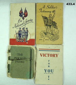
Booklet - BOOKS, 1939 -1946
The Prayer books belonged to Frederick Ernest ADDLEM V122087, VX142253. Refer Cat No 432.2 for his service history and 937P..1) Prayer book "On National Service". Beige cardboard covers, flags, 3 uniformed servicemen with map of Australia behind. Inside a space is available for name, rank and serial number. .2) Prayer book "Victory for you !" 12 pages, beige paper covers, red and blue printing. .3) Prayer book "The Pocket Padre". 28 pages, light green cardboard covers, black printing. .4) Prayer book "A Soldiers Testimony". 20 pages, light yellow covers, soldier on map of Australia with a flag.1.) Fred Addlem Pte V122087 57/60 Btn H.2 Coy Neereman Love from Gordon 10th Dec 42 .2) Love from Lorna 10th Dec 42 books - religon, military history