Showing 10440 items
matching sections
-
 Mont De Lancey
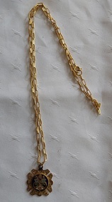
Ceremonial object - Rechabite Medallion, Henry Decru, early 1900's
The term Rechabites refers to a religious order, similar in some ways to the Nazirites, and they are mentioned by Eusebius of Emesa. In more recent times, the name has been used by Christian groups keen to promote total abstinence from alcohol, such as the Independent Order of Rechabites. The chain was added by Mrs Clarrie Rouget - daughter-in-law.A small gold I.O.R Independent order of Rechabites medallion on a gold open paperlink style chain to be worn around the neck. It has eight flat star shape points around the edge of a round blue centre which has a shield with symbols representing the Rechabites. On the back is the inscription as noted in detail in the next section below. The chain was added by Mrs Clarrie Rouget - daughter-in-law. It is displayed in a velvet purple jewelley box which has a cream and flock lining. The jeweller's name printed in gold letters inside the lid may not be the original maker of the medallion, but possibly made the link chain.'IOR Presented to Bro James Rouget PCR Eighteen Years Treasurer No 246 Tent 12th -4- 1909.' 'Henry Decru Watchmaker and Jeweller Main St. Croydon & Lilydale Ph 7257613 - PH 7351511'medallions, commemorative medallions, objects of vertu -
 Bendigo Historical Society Inc.
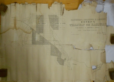
Map - MARKS COLLECTION: TRAMWAY OR RAILWAY MAP SANDHURST
Original map of 'land granted as endowment' for tramway or railway. On top Rh corner of map, in bold print 'Sandhurst, Inglewood & Loddon district Tramway or Railway. Land granted as endowment shaded, scale 60 chains to 1 inch. Lithographed by J & W. Holmes, Lith. Sandhurst'. Signed by Geo Avery Fletcher, Engineer. Map shows Parish of Leichardt, Parish of Yarraberb, Parish of Bridgwater and a section of Marong. On bottom RH corner, is small map of Sandhurst, showing railway reserve. Top LH corner, Inglewood. Map shows route of railway line from Sandhurst to Inglewood.map, marks collection, railway, inglewood -
 Bendigo Military Museum
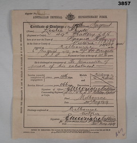
Administrative record - CERTIFICATE OF DISCHARGE WW1, 22.5.1919
Leslie PRYDE "MM". Refer Cat No 914 for his service history and award.A brief description of enlistment, service and discharge on both sides of the document. The document is a fawn colour, thicker than paper but able to be folded in 3 for postage. The front is divided into 3 sections, top being name, rank and serial number, age, enlistment date, unit and birth place. Centre is reason for discharge, service time, awards and decorations. Bottom is signed of by relevant person. The rear is dedicated to the individuals height, complexion, eye and hair colour, age on discharge and trade or calling prior to enlistment, intended place of residence. The person then signs the document. All entries on the form are hand written.On the front at top is a Register No: Unreadable On the rear are 2 numbers; “V/B No 41745 & No 124038”certificate, military history, numismatics, mm -
 Bendigo Military Museum
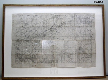
Map - TRENCH MAPS, FRANCE, 38th BN ON THE SOMME, 1).2) 1918, .3) system generated
The story covers mostly men of C Coy 38th Bn as well as others to give a broader pictutre. Edgar Stanbury MM as a C Coy Scout retrieved the maps from Capt G.A Dutton who was KIA. Stanbury then proceeded to keep reconnoitering towards Clery until they reached trenches near Clery Copse. The photos relate to the following, Jack Grinton, Bert Grinton, Edgar Stanbury, C.E. Newton, D.T.Hull, A.E.Pegler, Albert Gilhooley, C.E.A.Dunn, Hugh Pippin, G.A.Dutton, C.J.Holmes, Capt Selleck, Major Maudsley, last photo is labelled “Past Clery Copse”. Jack Grinton No 1043 C Coy, refer Cat No 1280. Bert Grinton No 5024 C Coy, awarded DCM 31.8.1918, refer Cat No 1320P. Edgar Stanbury No 997 C Coy, awarded MM 1917, WIA 2nd occasion 31.8.1918, refer Cat No 5032.3P. Charles Newton No 951 C Coy, awarded MM 26/31.8.1918. David Hull No 904 C Coy, Gassed 24.8.1918. Albert Gilhooley No 890 C Coy, KIA 31.8.1918, refer Cat No 5047. Augustus Pegler No 967 C Coy, awarded MM 31.8.1918. Cyril Dunn No 3058 7th Reo’s C Coy, KIA 31.8.1918. Hugh Pippin No 1895 2nd Reo’s C Coy, WIA 2nd occasion 11.8.1918, refer Cat No 1502. George Dutton Lieut No 532 C Coy, KIA 29.8.1918. (Photo of his name on Map & note to Jack Grinton) Charles Holmes No 910 C Coy, KIA 24.8.1918. (Photo of original grave) Horace Selleck Capt C Coy, KIA 19.7.1918, refer Cat No 1515. (Photo of address book) Arthur Fyfe No 1841 2nd Reo’s C Coy, KIA 30.8.1918. (Photo of original grave) Arthur Maudsley Major D Coy, KIA 31.8.1918. (Photo of original grave) Fyfe, Maudsley and Duttons graves are in the one photo. Last photo labelled “Past Clery Copse” This is the area where Bert Grinton is awarded the DCM on 31.8.1918, photo was taken by his brother Jack. .1) Map of France, trenches corrected to 15.4.1918, 1/20,000, Sheet 62D N.E, covers an area from Ribemont to Bray. .2) Map of France, trenches corrected to 6.3.1918, 1/20,000, sheet 62C N.W, covers area from Suzanne to Mt St Quentin. Both maps follow the Somme River. .3) Photo - story covers the events relating to the two maps from July 17th. - Sept 1st 1918 on the Somme . There are 14 photos with the story, 3 sections make up the story, Map 1, Map 2 and then details on the advance, the men, casualties and other.maps, 38th bn, c coy, the somme -
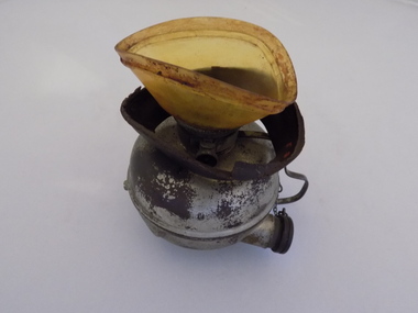 Geoffrey Kaye Museum of Anaesthetic History
Equipment - Inhaler, Hewitt, George Barth & Co. Ltd, c. 1895
Sir Frederic W. Hewitt (1857-1916), an accomplished and well respected English anesthesiologist, was an expert in the function and use of the Clover Ether Inhaler. In 1901, Hewitt described his modification of the Clover Inhaler. Often referred to as the Hewitt Wide-Bore Inhaler, Dr. Hewitt introduced changes in order to make it easier to breathe through the device and improve the ventilation of oxygen and carbon dioxide. In 1901, Hewitt was recruited to anesthetize King Edward VII for emergency abdominal surgery. This was just a day or so before the new King was to be coronated. He recovered well, and Hewitt became the first anesthesiologist ever to be knighted. (Source: Wood Library Museum)Tall black round topped box with brass hooks at the sides and brass hinges at rear. There is a brown fabric handle on the top. The box has red padding inside the lid and red lining inside the base and sides. There is a round section in the base of the box for holding the round clear glass bottle for ether. There is also a ellipse-shaped metal inhaler on small metal base with a thin metal handle and pipe with bakelite plug attached via a small metal chain. A brown mask is made of brown leather and celluloid which is connected to the inhaler. There is a metal ether measure for pouring the ether.On notecard in box: (B) HEWITT'S INHALER 1895, MADE BY GEO. BARTH & CO LTD., ADVERTISED AS THE SOLE MAKERS OF THE INHALER AND RECOGNISED BY HEWITT IN HIS TEXT BOOK - ANAESTHETICS AND THEIR ADMINISTRATION - AS THE MAKER OF HIS INHALER. / GIVEN BY DR. E.S. HOLLOWAY IN 1951, WHO ACQUIRED MUCH OF HOWARD JONES' EQUIPMENT AFTER THE LATTER'S DEATH. Stamped on underside of glass bottle in a circle: WUBW [illegible] Blue sticker on inhaler: O.2.13. Printed on inhaler under handle: Geo Barth [illegible] / SOL [illegible] Printed on body of inhaler: Full Printed on body of inhaler: 1/2 Printed on inside of leather mask: F35hewitt, sir frederic, jones, howard, inhaler, geo. barth & co. ltd., ether -
 Bendigo Historical Society Inc.
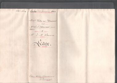
Legal record - BROWN Frank Miller - Lease agreement, Watson, James & Rogers, Rogers Collection, 1903
In the early 1980s the firm of Watson, James & Rogers merged with the partnership of Every & Every and became the iconic “Rogers & Every” as known today. The firm is still located on Bull Street. https://rogersevery.com.au/about/* Lease agreement between Edmund Kirby, Charles Horwood, Rachel Horwood, Norman Horwood, Stanley Horwood and Ivy Horwood with Frank Miller Brown of Back Creek in regards to Crown Allotments 1, 2, 3, 4, 17, 18,and 19 of Section 9B , Town of Sandhurst, County of Bendigo. Lease contains long list of machinery and equipment. Dated 27 January 1903. * Handwritten note from Kirby, Cohen and Woodward concerning the lease. Dated 12 February 1903. * Invoice dated 12 February 1903 concerning professional services from Kirby, Cohen and Woodward.Signatureswatson james & rogers, bendigo, legal documents, horwood, kirby -
 Kiewa Valley Historical Society
Postcard Circa 1950, Snow Plough, Bogong High Plain,5,500 Feet Kiewa Hydro-Electric Project, Circa 1950
This postcard was produced in the 1950's for the tourist trade in the Kiewa Valley and Alpine region. It encompasses the period when the State of Victoria was pressured by the ever increasing demand by industry and its population for electricity supplies. Hydro electricity was seen as an untapped natural resource to quench this demand. The Victorian Alps and the rivers flowing into its valleys was ideal for the construction of the Kiewa Hydro Electricity Scheme. The late 1940's saw the development of this scheme and the changing of sections of alpine landscape is covered by this and other postcards/pictures (tourists, construction workers, and established rural populations). This period in time was before the established wildlife and forest/nature groups became political activist who changed legislative acts to protect the environment. This rural region (Kiewa Valley/alpine plains) was at most only significant to a smaller group of winter sports, summer hikers/horse riders and rural farmers/graziers. The numbers of tourists and the increase in the local resident population was boosted by the construction of the Hydro Electricity Scheme. This influx to the regional population resulted in a corresponding diversity in services and brought about an environment that responded to a growing level of tourists and thereby permitting this industry to grow more rapidly than it would have naturally. This postcard details an attraction to the "cleaner" method of providing electricity. This postcard was purchased in 1950 by a surveyor at Landford's Gap. This item is a black and white photograph(professional) of a panoramic view of a snow plough clearing the unsealed road in 1950.This postcard is on quality paper and the reproduction of the picture is of a high standard.For other "tourist" postcards see 0480 (A) -(F) for other photos of similar postcards. kiewa valley tourism, victorian alps, alternate energy supplies, alpine population growth, secv, snow plough -
 Kiewa Valley Historical Society
Postcard Circa 1950, Road to Bogong High Plains Kiewa Hydro Electric Project, Circa 1950's
This postcard was produced in the 1950's for the tourist trade in the Kiewa Valley and Alpine region. It encompasses the period when the State of Victoria was pressured by the ever increasing demand by industry and its population for electricity supplies. Hydro electricity was seen as an untapped natural resource to quench this demand. The Victorian Alps and the rivers flowing into its valleys was ideal for the construction of the Kiewa Hydro Electricity Scheme. The late 1940's saw the development of this scheme and the changing of sections of alpine landscape is covered by this and other postcards/pictures (tourists, construction workers, and established rural populations). This period in time was before the established wildlife and forest/nature groups became political activist who changed legislative acts to protect the environment.This rural region (Kiewa Valley/alpine plains) was at most only significant to a smaller group of winter sports, summer hikers/horse riders and rural farmers/graziers. The numbers of tourists and the increase in the local resident population was boosted by the construction of the Hydro Electricity Scheme. This influx to the regional population resulted in a corresponding diversity in services and brought about an environment that responded to a growing level of tourists and thereby permitting this industry to grow more rapidly than it would have naturally. This postcard details an attraction to the "cleaner" method of providing electricity. This postcard was purchased in 1950 by a surveyor at Landford's Gap.This black and white photograph on a Valentine's postcard is from a V2 Argus photograph.. It is on a 200g/m paper density photo side gloss. See 0480 (A) - (G) for other photos of similar postcards.In white lettering " ROAD TO BOGONG HIGH PLAINS KIEWA HYDRO-ELECTRIC PROJECT", V3secv, road making, victorian alps -
 Kiewa Valley Historical Society
Postcard - Rocky Valley - Circa 1950, 1950
This postcard was produced in the 1950's for the tourist trade in the Kiewa Valley and Alpine region. It encompasses the period when the State of Victoria was pressured by the ever increasing demand by industry and its population for electricity supplies. Hydro electricity was seen as an untapped natural resource to quench this demand. The Victorian Alps and the rivers flowing into its valleys was ideal for the construction of the Kiewa Hydro Electricity Scheme. The late 1940's saw the development of this scheme and the changing of sections of alpine landscape is covered by this and other postcards/pictures (tourists, construction workers, and established rural populations). This period in time was before the established wildlife and forest/nature groups became political activist who changed legislative acts to protect the environment.This rural region (Kiewa Valley/alpine plains) was at most only significant to a smaller group of winter sports, summer hikers/horse riders and rural farmers/graziers. The numbers of tourists and the increase in the local resident population was boosted by the construction of the Hydro Electricity Scheme. This influx to the regional population resulted in a corresponding diversity in services and brought about an environment that responded to a growing level of tourists and thereby permitting this industry to grow more rapidly than it would have naturally. This postcard details an attraction to the "cleaner" method of providing electricity. This postcard was purchased in 1950 by a surveyor at Landford's Gap.This black and white photograph is from a Valentine's V2 Argus postcard. It is on a 200g/m paper density one side gloss. See also KVHS 0480 (A) to (L) for similar postcards. "ROCKY VALLEY FROM BOGONG HIGH PLAINS KIEWA HYDRO-ELECTRIC PROJECT" "V1"kiewa valley tourism, victorian alps, alternate energy supplies, alpine population growth, rocky valley, secv -
 Kiewa Valley Historical Society
Postcard - Junction Dam - Circa 1950, Circa 1950's
This postcard was produced in the 1950's for the tourist trade in the Kiewa Valley and Alpine region. It encompasses the period when the State of Victoria was pressured by the ever increasing demand by industry and its population for electricity supplies. Hydro electricity was seen as an untapped natural resource to quench this demand. The Victorian Alps and the rivers flowing into its valleys was ideal for the construction of the Kiewa Hydro Electricity Scheme. The late 1940's saw the development of this scheme and the changing of sections of alpine landscape is covered by this and other postcards/pictures (tourists, construction workers, and established rural populations). This period in time was before the established wildlife and forest/nature groups became political activist who changed legislative acts to protect the environment.This rural region (Kiewa Valley/alpine plains) was at most only significant to a smaller group of winter sports, summer hikers/horse riders and rural farmers/graziers. The numbers of tourists and the increase in the local resident population was boosted by the construction of the Hydro Electricity Scheme. This influx to the regional population resulted in a corresponding diversity in services and brought about an environment that responded to a growing level of tourists and thereby permitting this industry to grow more rapidly than it would have naturally. This postcard details an attraction to the "cleaner" method of providing electricity. This postcard was purchased in 1950 by a surveyor at Landford's Gap.This black and white photograph is a Valentine's postcard, from a V2 Argus photograph. It is on a 200g/m paper density with only the photo side gloss.Front "JUNCTION DAM & SPILLWAY, BOGONG KIEWA HYDRO-ELECTRIC PROJECT" on the flip side "VALENTINE'S POST CARD " "A GENUINE PHOTOGRAPH"kiewa valley tourism, victorian alps, alternate energy supplies, alpine population growth, junction dam, secv -
 Kiewa Valley Historical Society
Postcard - Junction Dam - Circa 1950, Circa 1950
This postcard was produced in the 1950's for the tourist trade in the Kiewa Valley and Alpine region. It encompasses the period when the State of Victoria was pressured by the ever increasing demand by industry and its population for electricity supplies. Hydro electricity was seen as an untapped natural resource to quench this demand. The Victorian Alps and the rivers flowing into its valleys was ideal for the construction of the Kiewa Hydro Electricity Scheme. The late 1940's saw the development of this scheme and the changing of sections of alpine landscape is covered by this and other postcards/pictures (tourists, construction workers, and established rural populations). This period in time was before the established wildlife and forest/nature groups became political activist who changed legislative acts to protect the environment.This rural region (Kiewa Valley/alpine plains) was at most only significant to a smaller group of winter sports, summer hikers/horse riders and rural farmers/graziers. The numbers of tourists and the increase in the local resident population was boosted by the construction of the Hydro Electricity Scheme. This influx to the regional population resulted in a corresponding diversity in services and brought about an environment that responded to a growing level of tourists and thereby permitting this industry to grow more rapidly than it would have naturally. This postcard details an attraction to the "cleaner" method of providing electricity. This postcard was purchased in 1950 by a surveyor at Landford's Gap.This black and white photograph on a Valentine's postcard is from a V2 Argus photograph. It is on a 200g/m paper density one side gloss only/. See 0480 (A) -(L) for other photos of similar postcards."JUNCTION DAM & SPILLWAY, LAKE GUY, BOGONG, KIEWA HYDRO-ELECTRIC PROJECT" "V5" on the flip side" VALENTINE'S POST CARD " "A GENUINE PHOTOGRAPH"kiewa valley tourism, victorian alps, alternate energy supplies, alpine population growth, junction dam, secv -
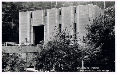 Kiewa Valley Historical Society
Postcard Circa 1950, No.3 Power Station Kiewa Hydro-electric Project "V.8", Circa 1950
This postcard was produced in the 1950's for the tourist trade in the Kiewa Valley and Alpine region. It encompasses the period when the State of Victoria was pressured by the ever increasing demand by industry and its population for electricity supplies. Hydro electricity was seen as an untapped natural resource to quench this demand. The Victorian Alps and the rivers flowing into its valleys was ideal for the construction of the Kiewa Hydro Electricity Scheme. The late 1940's saw the development of this scheme and the changing of sections of alpine landscape is covered by this and other postcards/pictures (tourists, construction workers, and established rural populations). This period in time was before the established wildlife and forest/nature groups became political activist who changed legislative acts to protect the environment.This rural region (Kiewa Valley/alpine plains) was at most only significant to a smaller group of winter sports, summer hikers/horse riders and rural farmers/graziers. The numbers of tourists and the increase in the local resident population was boosted by the construction of the Hydro Electricity Scheme. This influx to the regional population resulted in a corresponding diversity in services and brought about an environment that responded to a growing level of tourists and thereby permitting this industry to grow more rapidly than it would have naturally. This postcard details an attraction to the "cleaner" method of providing electricity. This postcard was purchased in 1950 by a surveyor at Landford's Gap.This black and white photograph from a Valentine's postcard is from a V2 Argus photograph postcard. It is on a 200g/m paper density photo side gloss. See 0480 (A) - (K) for other photos of similar postcards."No.3 POWER STATION KIEWA HYDRO ELECTRIC PROJECT" "V8"kiewa valley tourism, victorian alps, alternate energy supplies, alpine population growth, secv -
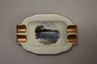 Warrnambool and District Historical Society Inc.
Ashtray, Alka Kunst, Warrnambool Hopkins River, c. 1960
This item was bought as a souvenir of Warrnambool in the mid 20th century when cigarette smoking was more widespread and was socially acceptable. Tourism in Warrnambool has been an important industry for over 100 years. In the late 19th century Warrnambool was promoted as a spa resort with its mild climate, sea bathing and its hot and cold sea water baths complex. Today visitors come in winter for the May Racing Carnival and to see the Southern Right whales at Logans Beach and in summer they come for a beach holiday. The image on the dish shows the Warrnambool Hopkins River near its mouth. The boatshed is no longer there with sections of the building being relocated to a site in Henna Street and used for indoor recreational purposes.This ash tray is retained as an example of a local tourist souvenir sold to tourists in the 1960s. This is a small white china dish made in an oval shape and slightly raised from the surface on which it sits. The ends of the dish have four gold coloured indents for stubbing cigarettes. There is a gold rim around the edge of the dish and a coloured image of the old boat shed and jetty on the Hopkins River in Warrnambool. On the base of the dish is the logo of the maker and printed details.Warrnambool Hopkins River Alka Kunst Bavaria tourism in warrnambool, history of warrnambool -
 Bendigo Military Museum
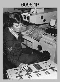
Photograph - Army Survey Regiment – Map Production, Fortuna, Bendigo, c1980s
These five photographs of map production and the car park area were taken at Fortuna, Bendigo, c1980s. The first three photographs were taken in Air Survey Squadron, where aerotriangulation and digital photogrammetric extraction of topographic features from aerial photography were undertaken. Photo .4P was taken in Cartographic Squadron’s Correcting Section, located in the Attic. The technicians were probably involved in a rapid response map production, as they all were wearing field uniforms. The Army Survey Regiment’s Duty Room, RAP and Carpark appear in Photo .5P. It was probably taken from the top steps near the SGT’s accommodation block in 1986. Photos .4P and .5P are also published with item 6395.17P.This is a set of five photograph of Map Production and car park, at the Army Survey Regiment, Fortuna, Bendigo, c1980s. The photographs were printed on photographic paper and is part of the Army Survey Regiment’s Collection. Photograph .1P was scanned at 200 dpi. The others were scanned at 300 dpi. .1) - Photo, black & white, c1980s: CPL Marrianne (Van De Zee) De Groot measuring aerial photographs with a stecometer. .2) - Photo, colour, c1980s: Two unidentified technicians assessing a flight line diagram. .3) - Photo, black & white, c1980s: SPR Scheryl Delforce digitising map features on an AUTOMAP 1 Graticon table. .4) - Photo, black & white, 1986: L to R: CPL Andy Lucas, SPR Chris Gordon, unidentified, SPR Jan (Crighton) Minchin, SPR Robin Marshall, CPL Frank Downie, SPR Gayle Humphrey, unidentified technicians in the Attic, Fortuna. .5) - Photo, black & white, 1986: Army Survey Regiment Duty Room, RAP and Carpark at Fortuna. .1P - Annotated on back ‘Maryanne Degroot’ .2P, .4P to .5P – no annotation .3P - Annotated on back ‘Scheryl Delforce’royal australian survey corps, rasvy, army survey regiment, army svy regt, fortuna, asr, air survey, carto, aerotrig -
 Federation University Historical Collection
Film - Video, Michelangelo Antonioni, Chung Kuo - Cina by Michelangelo Antoniolo, 1972
A documentary on China, concentrating mainly on the faces of the people, filmed in the areas they were allowed to visit. The 220 minute version consists of three parts. The first part, taken around Beijing, includes a cotton factory, older sections of the city, and a clinic where a Cesarean operation is performed, using acupuncture. In 1972, during Mao's Cultural Revolution, Michelangelo Antonioni was invited by the People's Republic of China to direct a documentary about New China. The result was a three-and-a-half-hour long film, divided into three parts. Mao disliked it so much that Michelangelo Antonioni was consequently charged with being anti-Chinese as well as counterrevolutionary. The movie was finally shown at Beijing's Cinema Institute 30 years later.The boxed video reels containt .1 - Reel One in black National Video Tape box .2 - Reel Two in black National Video Tape boxchung kuo - cina, michelangelo antonioli, video, video reel -
 Mission to Seafarers Victoria
Flyer, Clare McCracken, The Place Between, 2018
On the 21st of July 2018, Clare McCracken boarded the ANL Wahroonga container ship to travel to China mirroring her great-great-grandmother's journey from Australia to Asia in 1874. Artist statement from the back of the flyer: "In 1874, my great-great-grandmother, Elizabeth Amy Cathcart Payne, sailed unaccompanied from Australia to Asia, writing a detailed journal of her experiences. This exhibition weaves together sections of her diary with my own voyage from Australia to the world's busiest port, Shanghai. In doing so, The Place Between, is a meditation upon the social and political nature of international trade, the mobility and the place between Australia and the rest of the world in the 19th and 21st century." The Mission has always been open to the community and has a tradition of hosting cultural events: shows, concerts, exhibitions, festivals.Postcard size flyer advertising for an exhibitionthe place between, clare mccracken, cultural events, sea voyage, andrew ferris, arun munoz, video installation -
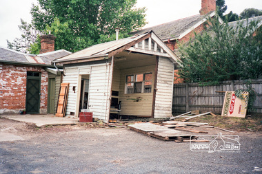
 Eltham District Historical Society Inc
Photograph, The former Police residence at 728 Main Road under renovation work for future Shire of Eltham use, c.Nov. 1991
The original Eltham Police Station was used up till about 1960. The building was then taken over and used by the Vermin and Noxious weeds Destruction Section of the Department of Crown Lands and Survey. They vacated the building c.March 1981 and it remained unoccupied for a period of time whilst its future was discussed in Council. About 1986 the Shire took over use of the Police Residence and renovated it for use by the Shire Parks and Environment Office. The original Police Station was termite infested and was removed. It was later replaced by a replica building which was used as a lunchroom for Council employees working at the site. Based on photos contained in the 1992 Bick Heritage Study of the Police Residence and Stable, this roll of film was taken Nov 1991.Roll of 35mm colour negative film, 7 stripsKodak GA 100 5095shire of eltham, justice precinct, police residence, police station, local history centre -
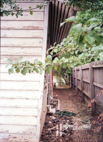
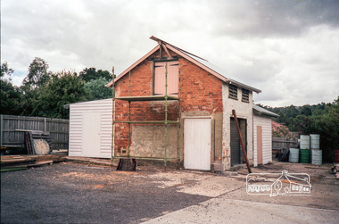
 Eltham District Historical Society Inc
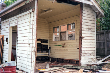
Photograph, The original Police Stables at 728 Main Road under renovation work for future Shire of Eltham use, c.Nov. 1991
The original Eltham Police Station was used up till about 1960. The building was then taken over and used by the Vermin and Noxious weeds Destruction Section of the Department of Crown Lands and Survey. They vacated the building c.March 1981 and it remained unoccupied for a period of time whilst its future was discussed in Council. About 1986 the Shire took over use of the Police Residence and renovated it for use by the Shire Parks and Environment Office. The original Police Station was termite infested and was removed. It was later replaced by a replica building which was used as a lunchroom for Council employees working at the site. Based on photos contained in the 1992 Bick Heritage Study of the Police Residence and Stable, this roll of film was taken Nov 1991.Roll of 35mm colour negative film, 7 stripsKodak GA 100 5095shire of eltham, justice precinct, police residence, police station, local history centre -
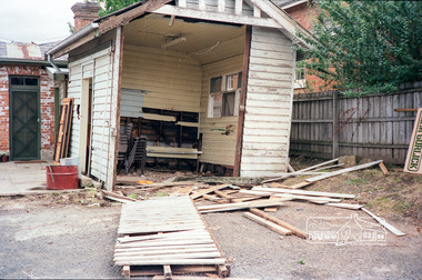
 Eltham District Historical Society Inc
Photograph, The original Police Stables at 728 Main Road under renovation work for future Shire of Eltham use, c.Nov. 1991
The original Eltham Police Station was used up till about 1960. The building was then taken over and used by the Vermin and Noxious weeds Destruction Section of the Department of Crown Lands and Survey. They vacated the building c.March 1981 and it remained unoccupied for a period of time whilst its future was discussed in Council. About 1986 the Shire took over use of the Police Residence and renovated it for use by the Shire Parks and Environment Office. The original Police Station was termite infested and was removed. It was later replaced by a replica building which was used as a lunchroom for Council employees working at the site. Based on photos contained in the 1992 Bick Heritage Study of the Police Residence and Stable, this roll of film was taken Nov 1991.Roll of 35mm colour negative film, 7 stripsKodak GA 100 5095shire of eltham, justice precinct, police residence, police station, local history centre -
 Kiewa Valley Historical Society
Postcard Circa 1950, Lake Guy Dam and Bogong Village, Circa 1950
This postcard was produced in the 1950's for the tourist trade in the Kiewa Valley and Alpine region. It encompasses the period when the State of Victoria was pressured by the ever increasing demand by industry and its population for electricity supplies. Hydro electricity was seen as an untapped natural resource to quench this demand. The Victorian Alps and the rivers flowing into its valleys was ideal for the construction of the Kiewa Hydro Electricity Scheme. The late 1940's saw the development of this scheme and the changing of sections of alpine landscape is covered by this and other postcards/pictures (tourists, construction workers, and established rural populations). This period in time was before the established wildlife and forest/nature groups became political activist who changed legislative acts to protect the environment.This rural region (Kiewa Valley/alpine plains) was at most only significant to a smaller group of winter sports, summer hikers/horse riders and rural farmers/graziers. The numbers of tourists and the increase in the local resident population was boosted by the construction of the Hydro Electricity Scheme. This influx to the regional population resulted in a corresponding diversity in services and brought about an environment that responded to a growing level of tourists and thereby permitting this industry to grow more rapidly than it would have naturally. This postcard details an attraction to the "cleaner" method of providing electricity. This postcard was purchased in 1950 by a surveyor at Landford's Gap.This black and white photograph from a Valentine's postcard is from a V2 Argus photograph postcard. It is on a 200g/m paper density photo side gloss. See 0480 (B) - (F) for other photos of similar postcards.In white lettering " LAKE GUY & BOGONG VILLAGE KIEWA HYDRO-ELECTRIC PROJECT"kiewa valley tourism, victorian alps, alternate energy supplies, alpine population growth -
 Kiewa Valley Historical Society
Postcard Circa 1950, Snowfall at Bogong Village Kiewa Hydro-Electric Project, 1950s
This postcard was produced in the 1950's for the tourist trade in the Kiewa Valley and Alpine region. It encompasses the period when the State of Victoria was pressured by the ever increasing demand by industry and its population for electricity supplies. Hydro electricity was seen as an untapped natural resource to quench this demand. The Victorian Alps and the rivers flowing into its valleys was ideal for the construction of the Kiewa Hydro Electricity Scheme. The late 1940's saw the development of this scheme and the changing of sections of alpine landscape is covered by this and other postcards/pictures (tourists, construction workers, and established rural populations). This period in time was before the established wildlife and forest/nature groups became political activist who changed legislative acts to protect the environment.This rural region (Kiewa Valley/alpine plains) was at most only significant to a smaller group of winter sports, summer hikers/horse riders and rural farmers/graziers. The numbers of tourists and the increase in the local resident population was boosted by the construction of the Hydro Electricity Scheme. This influx to the regional population resulted in a corresponding diversity in services and brought about an environment that responded to a growing level of tourists and thereby permitting this industry to grow more rapidly than it would have naturally. This postcard details an attraction to the "cleaner" method of providing electricity. This postcard was purchased in 1950 by a surveyor at Landford's Gap.This scanned black and white photograph of a postcard, shows vehicles covered in thick snow at Bogong Village in 1950. See 0480(A), (C) - (F) for other similar photos of postcards available at this period."SNOWFALL AT BOGONG VILLAGE KIEWA HYDRO-ELECTRICITY PROJECT"kiewa valley tourism, victorian alps, alternate energy supplies, alpine population growth, bogong village, secv -
 Kiewa Valley Historical Society
Postcard Circa 1950, Scene in Bogong Village Kiewa Hydro-Electric Project, 1950s
This postcard was produced in the 1950's for the tourist trade in the Kiewa Valley and Alpine region. It encompasses the period when the State of Victoria was pressured by the ever increasing demand by industry and its population for electricity supplies. Hydro electricity was seen as an untapped natural resource to quench this demand. The Victorian Alps and the rivers flowing into its valleys was ideal for the construction of the Kiewa Hydro Electricity Scheme. The late 1940's saw the development of this scheme and the changing of sections of alpine landscape is covered by this and other postcards/pictures (tourists, construction workers, and established rural populations). This period in time was before the established wildlife and forest/nature groups became political activist who changed legislative acts to protect the environment. This rural region (Kiewa Valley/alpine plains) was at most only significant to a smaller group of winter sports, summer hikers/horse riders and rural farmers/graziers. The numbers of tourists and the increase in the local resident population was boosted by the construction of the Hydro Electricity Scheme. This influx to the regional population resulted in a corresponding diversity in services and brought about an environment that responded to a growing level of tourists and thereby permitting this industry to grow more rapidly than it would have naturally. This postcard details an attraction to the "cleaner" method of providing electricity. This postcard was purchased in 1950 by a surveyor at Landford's Gap. The couple shown in this photograph would have been employed by the S.E.C. under the Kiewa Hydro-Electricity Scheme.This item is a scanned black and white photograph of a couple walking along a gravel street in Bogong Village in 1950. See 0480 (A) ,(B), (D) - (F) for other photos of similar postcards" SCENE IN BOGONG VILLAGE KIEWA HYDRO-ELECTRIC PROJECT"kiewa valley tourism, victorian alps, alternate energy supplies, alpine population growth, bogong, secv -
 Kiewa Valley Historical Society
Postcard Circa 1950, Howman Gap Hostel under snow Kiewa Hydro-Electric Project, Circa 1950
This postcard was produced in the 1950's for the tourist trade in the Kiewa Valley and Alpine region. It encompasses the period when the State of Victoria was pressured by the ever increasing demand by industry and its population for electricity supplies. Hydro electricity was seen as an untapped natural resource to quench this demand. The Victorian Alps and the rivers flowing into its valleys was ideal for the construction of the Kiewa Hydro Electricity Scheme. The late 1940's saw the development of this scheme and the changing of sections of alpine landscape is covered by this and other postcards/pictures (tourists, construction workers, and established rural populations). This period in time was before the established wildlife and forest/nature groups became political activist who changed legislative acts to protect the environment.This rural region (Kiewa Valley/alpine plains) was at most only significant to a smaller group of winter sports, summer hikers/horse riders and rural farmers/graziers. The numbers of tourists and the increase in the local resident population was boosted by the construction of the Hydro Electricity Scheme. This influx to the regional population resulted in a corresponding diversity in services and brought about an environment that responded to a growing level of tourists and thereby permitting this industry to grow more rapidly than it would have naturally. This postcard details an attraction to the "cleaner" method of providing electricity. This postcard was purchased in 1950 by a surveyor at Landford's Gap.This item is a scanned black and white photograph of a panoramic view of Howman Gap Hostel under snow in 1950 (a closed village, entry by pass only). This accommodation was for construction workers only. See 0480 (A) -(E) for other photos of similar postcards.On the photo, " Howman Gap Hostel under snow Kiewa Hydro-Electric Project" . On postcard address and personal information side "V.2 Valentine's Post Card "kiewa valley tourism, victorian alps, alternate energy supplies, alpine population growth, bogong, secv, howman's gap hostel