Showing 793 items
matching land allotments
-
 Ringwood and District Historical Society
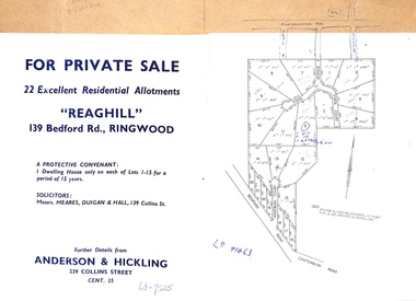
Document - Folder, Reaghill Estate Subdivision, Ringwood, Victoria - circa 1958
Bifold land sale brochure glued to brown stationery folder with advertisement including map of original subdivision (circa 1958) and subsequent 1982 re-subdivision of Lot 7 Vista Avenue - LP41463 - Part of Crown Allotment 43, Parish of Ringwood, and 4-page brochure for sale of 4 luxury new homes built by Bovis Homes Aust. P/L as presented by Lyndsay Edmonds Homes. Subdivision includes Bedford Road, Homebush Court, Vista Avenue and Vista Court. Original protective covenant: "One dwelling house only on each of Lots 1-15 for a period of 15 years". Agent - Anderson & Hickling, 239 Collins Street, Melbourne. (Phone) Cent.25. -
 Ringwood and District Historical Society
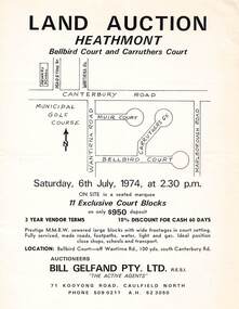
Flyer - Land Auction, Carruthers Estate, Heathmont, Victoria - 1974
Double-sided page advertising auction of 11 allotments on Saturday, 6th July, 1974, with locality map and plan of subdivision in Carruthers Court and Bellbird Court, Heathmont. $950 deposit, 3 year vendor terms, 10% discount for cash 60 days. Handwritten notation indicating Lot 22 "sold for $127,000 - all other lots passed in around $11,000".Auctioneers - Bill Gelfand Pty. Ltd., R.E.S.I. 71 Kooyong Road, Caulfield North, Phone 5090211 A.H. 523050. -
 Bendigo Historical Society Inc.
Document - H. A. & S. R. WILKINSON COLLECTION: HAND WRITTEN NOTE
Hand written note. Volume 1200, folio 239806. Schroeder part Crown allotment 18 section H Eaglehawk. A drawing of a block of land also the name James Stewart on the left.organization, business, h.a. & s.r wilkinson real estate -
 Ringwood and District Historical Society
Document - Folder, Land Sale - Monterey Park Subdivision, Warrandyte Road, Ringwood North, Vic. - 1981
Foolscap manilla folder containing double-sided flyer advertising residential subdivision development, including outline of local facilities and services, with locality map and layout of Monterey Park streets. Subdivision includes Parkwood High School, Tortice Drive, Heape Way, Appleberry Place, Stringybark Court, Conifer Court, Crawley Grove, Monterey Close (later Monterey Place), Lucy Place, Middlebrook Drive, Gahnia Close, Glanfield Court, Cone Close, Jull Parade, Pinus Close (later Pinetree Court), Radiata Close, Old Warrandyte Road, and entry from Warrandyte Road. Vendor - Jennings Industries Limited, 690 Springvale Road, Mulgrave, 3170, Phone 5618000. A4 enclosures with tables showing each allotment List Price, Builders Price, Cash Price and Terms Price. Information page headed "Form of Restrictive Covenant to be incorporated in Transfer" specific to Certificates of Title. Restrictive Covenant (summary): (Name/s) "... will not erect or construct or cause to be erected or constructed on the land hereby transferred (a) Any front boundary fence, other than a fence which does not exceed one metre in height unless the same is set back as least 1.5 metres from the front boundary and the same is effectively screened from that boundary by the planting of trees, shrubs or plants. (b) Any side boundary fence other than a fence which is set back at least 1.5 metres from the front boundary on which does not exceed 1 metre in height within 1.5 metres of the front boundary. (c) For a period of 5 years from the date hereof, any building on the said land unless and until the Plans and Specifications thereof have first been approved by the said Residential Developments Pty. Limited. (d) For a period of 2 years from the date hereof whilst the said land remains vacant any Signboard or Notice advertising the sale of the said lot or any other lot. These covenants shall appear on the Certificate of Title to issue for the said land and run with the land." -
 Ringwood and District Historical Society
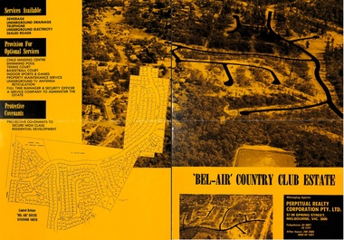
Flyer, Land Sale Brochure, Bel-Air Country Club Estate, North Ringwood - circa 1978
Double sided A2 size yellow and black gloss print advertisement for residential subdivision, with progressive allotment price list notices. Subdivision includes Glenvale Road, Kubis Drive, June Square, Jenkins Close, Werac Drive, Manuela Terrace, Rudolf Court, Lyn Court, Burlock Avenue, Debbie Place, Pamela Place, Iluka Place, Chifley Parade, Menzies Crescent.Vendor and Managing Agents - McKuke Pty Ltd (Frank Kubis) and Perpetual Realty Corporation Pty. Ltd., 97-99 Spring Street, Melbourne, Vic. 3000. Telephone 63 4881, 63 3721, After hours 299 2085, (059) 84 1381. -
 Bendigo Historical Society Inc.
Document - LANDS OFFICE - SALE OF CROWN LAND BY AUCTION, 1892 - 1920
Document: dark green hard cover journal with buff spine and corners. Contains details of public auctions of crown lands in fee simple at various locations in northern Victoria. Printed details of auctions pasted for each sale. LH page: lot, county, parish, section, allotment, sold, unsold, why not sold, upset price, sold for. RH page: value of improvements if any, name of purchaser, residence, deposit forfeited, total amount.Lands Officelands office, crown lands, auction, northern victoria -
 Ringwood and District Historical Society
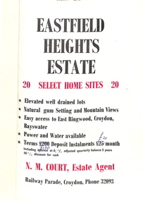
Flyer, Land Sale Brochure, Eastfield Heights Estate, Croydon. (Undated, circa 1950s)
Bi-fold advertisement for 20 residential allotments with locality map of East Ringwood-Croydon area and map of subdivision bounded by Eastfield Road, and The Pass, Croydon. Agent - N.M. Court, Railway Parade, Croydon, Phone 32093. -
 Ringwood and District Historical Society
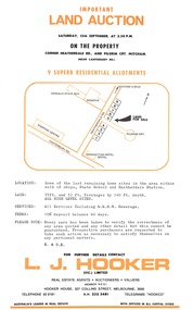
Flyer, Residential Land Auction - Heatherdale Road, Ringwood - 1973
Single-page advertisement for auction on Saturday 15th September (1973) - 9 residential allotments on Heatherdale Road, Ringwood. Includes summary of local services and facilities, and map of area showing Verdale State School, Manhattan Hotel-Motel, and directional arrow 3/4 mile to railway station (Heatherdale) to the north.Agent - L.J. Hooker Vic. Limited, Hooker House, 327 Collins Street, Melbourne 3000, Telephone 62 0181, A.H. 232 3481, Telegrams HOOKCO. -
 Ringwood and District Historical Society
Document - Folder, Land Sale, Parkhaven Estate, Heathmont, Victoria - 1968
Manilla folder containing 2-page foolscap size typewritten summary of Parkhaven Estate Heathmont multiple release allotment prices and two maps headed Plan of Subdivision - Part of Crown Portion 13, Parish of Ringwood. Subdivision includes Cuthbert Street, Waterloo Street, Sunset Drive, Markhill Place, Parkhaven Drive, Bayley Close and Blenheim Street. Agents - Consolidated Home Industries Limited, Lower Dandenong Road, Braeside, Vic., Phone 91-9791. Rep - Bruce Grant.Accompanying handwritten sales note researched in 2024 by Richard Carter - Carter Real Estate - "Generally $2500 to $4000 per lot". -
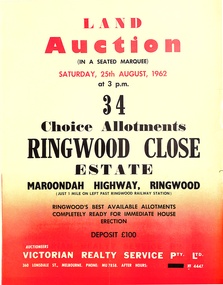 Ringwood and District Historical Society
Pamphlet, Land Auction Brochure - Ringwood Close Estate, Ringwood, Victoria - 1962
Brochure advertising public auction of 34 allotments on Saturday 25th August, 1962. Brochure includes terms of sale, description of subdivision features and local facilities, with locality map. Subdivision includes Anthony Court, Nina Court and Wingrove Place, off Maroondah Highway, Ringwood.Auctioneer - Lindsay Lord, Victorian Realty Service Pty Ltd., 360 Lonsdale Street, Melbourne. Phone MU7858, After hours XF4447. Map includes handwritten pricing notations for some allotments. -
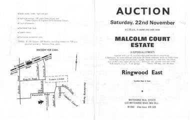 Ringwood and District Historical Society
Flyer, Land Auction Brochure, Malcolm Court Estate, Ringwood East, Vic. - 1969
... allotments. Land Auction Brochure, Malcolm Court Estate, Ringwood ...Bi-folded single sheet with black print both sides advertising Auction on Saturday, 22nd November, 1969. Details include location map, vendor terms, subdivision features and local facilities. Centre page shows allotment numbers and property dimensions. Agent - Whitehorse Real Estate, 1123 Whitehorse Road, Box Hill, (Phone) 890502, After hours 8781429. Separate copy of map with handwritten sale notations for some allotments.LP 859686 -
 Eltham District Historical Society Inc
Photograph - Digital Photograph, Alan King, Panton Hill Hotel, 27 March 2008
Today’s Panton Hill Hotel was built around 1920. Published: Nillumbik Now and Then / Marguerite Marshall 2008; photographs Alan King with Marguerite Marshall.; p61 Panton Hill was originally known as Kingstown, and consisted of only one hotel when the Orams Reef was discovered in 1859. Kingstown was a quartz mining centre and many old mine shafts remain in the area. Orams Reef was one of the first reefs with a rich find of gold in the area. The Hotel Francais, which had been operating in 1861, was well situated on the way to Queenstown (later St Andrews). So was Herr Hirt’s Hotel and store at Smiths Gully. The Kingstown hotel, known as the Frenchman’s and in 1864 as the Hotel de France, was run by a Monsieur Emile Hude and his wife Jeanne, and known for its good food. They hosted social events, business conventions and debates, attracting patrons from as far as Melbourne. The hotel’s name was changed to Panton Hill Hotel in 1905. In 1883 Charles Caudwell built another hotel nearby, possibly in Long Gully Road,3 which it is thought, was burnt down early last century. Today’s Panton Hill Hotel, built around 1920, is the only one of the cluster of buildings in the main road, not to date from around the turn of last century. It was severely damaged by fire in 2003, then underwent extensive alterations. It is the township’s only hotel and is an example of a modest hotel building exterior, constructed early last century. In its early days the hotel also housed the first post office, newsagency and store. Orams Reef yielded a total of £100,000, and fossikers also found alluvial gold in the creeks and gullies, but there is no record of the total value of their finds. Gold greatly increased the Panton Hill population, which peaked between 1865 and 1885. On holidays large sports meetings were held with wood chopping contests and foot races and the day would end with a ball. Miners came from various countries to seek their fortune, including many from China. The Chinese became unpopular however, and gradually left the district, although some stayed and grew and sold vegetables.5 Panton Hill was named after Joseph Panton, who in 1862 was appointed Police Magistrate for the Woods Point, Heidelberg and Yarra districts. Panton was an outstanding man, who in 1852, was Commissioner of Crown Lands and Assistant Commissioner of Goldfields at Bendigo. In 1874 he was promoted to Chief Magistrate for the Melbourne Police. Panton was also an artist, becoming president of the Victorian Arts Society in 1888, and in 1913, president of the Royal Geographical Society. Despite Panton Hill’s prosperity, it still lacked many services as poor roads made access to Melbourne difficult. A horse-drawn mail coach travelled to Melbourne until 1890, when the railway came to Heidelberg. The nearest doctor was at Yarra Glen or Heidelberg, and the Indian hawker Singh’s annual visit was very welcome. A miner’s shack opposite the school was used as a post office. Today’s general store and post office in the main road dates from early last century, and has changed considerably. While most people searched for gold, the more enterprising ones established farms to feed the diggers. Farmers grew wheat, barley and oats, and sent animal skins to the Eltham tannery, to make furs in Melbourne. As gold became scarce from around 1880, miners took up farming on 19 to 20 acre (8ha) allotments. The first settlers in Cherry Tree Road included Purcell, Smith, Owens, Hughes and Shillinglaw. By 1900 all the land had been taken up around Panton Hill and Hurstbridge. The orchards in Panton Hill and the wider district, particularly of apple and pear, were very successful, and made Panton Hill a cohesive and successful community. About 1914 the Moores built the first cool-store and refrigeration plant at their orchard in Cherry Tree Road. Many settlers planted vineyards and made high quality wine, but in 1922 the blight destroyed them.This collection of almost 130 photos about places and people within the Shire of Nillumbik, an urban and rural municipality in Melbourne's north, contributes to an understanding of the history of the Shire. Published in 2008 immediately prior to the Black Saturday bushfires of February 7, 2009, it documents sites that were impacted, and in some cases destroyed by the fires. It includes photographs taken especially for the publication, creating a unique time capsule representing the Shire in the early 21st century. It remains the most recent comprehenesive publication devoted to the Shire's history connecting local residents to the past. nillumbik now and then (marshall-king) collection, panton hill hotel -
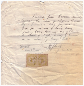 Linton and District Historical Society Inc
Receipt, Receipt for Payment for a Block of Land near Linton, 1918
Note that the block of land which was traded was not the block in Sussex Street, Linton on which the Sandows had a shop and house, but a block just outside the town boundary, near the Geelong Road (Linton-Naringhil Road). See map of Parish of Argyle for clarification.Photocopy of original handwritten receipt, which was for payment in full for a block of land situated just outside of Linton - Section A, Crown Allotment 1, Parish of Argyle. This land was purchased by Rubina (Ruby) Sandow from George Bolte in 1918. Receipt is for fifteen pounds, it is made out to "Rubinia Norwood Sandow" and is signed by Alf J. Smith, "for Geo. Bolte". Two Victorian Stamp Duty stamps are attached to the original document.rubina (ruby) sandow, george bolte, receipts, sale of land -
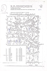 Ringwood and District Historical Society
Document, Land Sale Map and Price List - Pinewood Rise Subdivision, Ringwood, Victoria - (Undated, circa 1988)
Single page black & white photocopy of subdivision plan showing layout of 28 residential allotments with inset showing price list & some marked 'sold'.Director and Licensed Estate Agent - R.F. Jennings Pty Ltd., 8 Streeton Lane, Doncaster East 3109. Phone 842 7666 all hours. -
 Lakes Entrance Historical Society
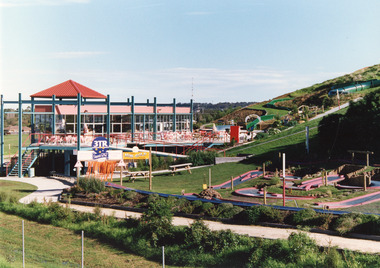
Photograph - Kinkuna, 2009
Kinkuna Amusement Park was opened 19 December 1987, closed 2002, building demolished or removed, land sold and subdivided into residential allotments.Copy colour photographic print showing Kinkuna Amusement Park on Princes Highway, owned by Joe and Shirley Walters. Photo shows main building and restaurant, mini golf, long taboggan on hill, garden and other attractions. Lakes Entrance Victoriaentertainment, recreation -
 Warrnambool and District Historical Society Inc.
Legal record - Warrnambool City Council
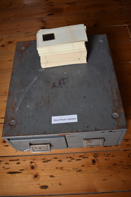
These items are original records from the Warrnambool City Council and contain information on land sales and sub-divisions within the city area for the second half of the 20th century. The ledger contains the names of those involved in the sale and transfer of land and the file cards give illustrative details of the allotments – plans, maps etc. These items are of considerable significance as they are Warrnambool City Council records dealing with land sales and sub-divisions in the second half of the 20th century. They will be useful for research. .1 A metal-bound ledger with a dark red leather cover and pages printed with red and blue lines. There are red alphabetical tabs with gold print attached to the outer edges of the pages. The entries are handwritten in blue ink. .2 A grey metal cabinet, rectangular in shape and rusted on the base. The cabinet has two drawers with handles and these drawers contain file cards. The cards have a negative or transparency inserted into the top corner. .3 File cards with a negative inserted and a green backing .4 File cards similar to .3 above but of a different size. .5 A packet of unused file cards with tabs land sales and sub-divisions, warrnambool city council -
 Warrnambool and District Historical Society Inc.
Document, signatures and a sketch map
This document comes from the Ardlie collection. It is presumed that it is part of the material that belonged to William Ardlie, a prominent lawyer in Warrnambool in the 19th and 20th centuries. It is not clear if the document is a copy or an original. It is an 1886 document in which the purchasers of Allotments 127,128 and 129 in Coulstock Street, Warrnambool requested a change to the original land situation. They wished to eliminate a laneway shown on the original purchase document owned by Adam Bell and transfer the lane land to the new purchasers. The signatures on the document include Isabella Helpman, R.D. Burall, Adam Bell, Anthony Derrick and another signature not able to be deciphered. The sheet includes a sketch showing the proposed change to the land division. This item is of minor interest as a document from the 19th century dealing with a land transfer proposal by some prominent Warrnambool residents at the timeThis is a sheet of paper with handwriting, signatures and a sketch map, all in black ink. The page is a little yellowed with age. adam bell, warrnambool, wiliam ardlie -
 Eltham District Historical Society Inc
Photograph - Digital Photograph, Alan King, Edendale Farm Homestead, 29 January 2008
Edendale Farm is Nillumbik Shire Council's environment centre situated in Gastons Road, Eltham between the railway and the Diamond Creek. The homestead on the property was built in 1896 and is of historical significance, being the subject of a Heritage Overlay under the Nillumbik Planning Scheme. The Edendale property was originally part of an extensive land purchase in 1852 from the Crown by pioneer Eltham farmer Henry Stooke. He initially purchased 51 acres and later expanded his holdings by purchasing another three adjacent Crown allotments extending northerly from Josiah Holloway's Little Eltham subdivision. Despite clearing the land, Stooke did not build on this property, choosing to live on his property "Rosehill" at Lower Plenty. In 1896 Thomas Cool, Club Manager of the Victoria Coffee Palace in Melbourne purchased 7 acres of the original Stooke land and built the house now known as Edendale. Cool did not farm the land, instead using it as a gentleman’s residence, retiring to Eltham at weekends. In 1918 he purchased an additional 7 acres but in 1919 he sold the property. Later owners included J.W. Cox, the Gaston family and D. Mummery. In the 1980s the Eltham Shire Council purchased the site for use as a Council depot, but this use did not proceed. Subsequently, it was used as the Council pound. The Edendale Farm Pet Education and Retention Centre was established in the summer of 1988/1989 and was set up to replace the existing dog kennels with a high standard pet retention centre. The design style of the building was established to compliment the features of the existing house. It was equipped with 10 retention pens, a veterinary room and a pet education area where school children and other interested parties learnt about pet care procedures. It was later developed into a community farm and was run by an advisory committee and in 2000 it became an Environment Centre. In early 2006 an advisory committee was established for the development of a master plan for future development at Edendale Farm. The committee included Russell Yeoman, a former long-time shire planner and founding member of the Eltham District Historical Society. At the time of filming the Master Plan and future for Edendale was about continuing to develop Edendale as a centre of environment learning and looking at expanding displays and school program, running a lot more of life-long learning and workshops around sustainable living. Covered under Heritage Overlay, Nillumbik Planning Scheme. Published: Nillumbik Now and Then / Marguerite Marshall 2008; photographs Alan King with Marguerite Marshall.; p101 A sharp turn from busy Wattletree Road by the railway line, brings a surprise. Only 1.4 km from Eltham’s centre, sheep feed, blissfully unaware of the hectic suburban activity so close by. At the entrance to the 5.6ha Edendale Farm is another surprise. A work of art that looks like huge tree trunks transformed into bowler and top-hatted men. The Fences Act 1968 by Tony Trembath with Mark Cain and John Doyle, 1996, is classified by the National Trust of Australia as having Regional Significance. The title refers to a government act on disputes between neighbors over the placement of fences and boundaries. This takes a ‘wry swipe’ at a community divided by trivial squabbles. It also celebrates making do with limited resources.1 Further along on the left, the office wall is decorated with a massive Eltham Copper Butterfly, designed by Robert Tickner and made by school children with used plastic bottles and other waste material. Nillumbik Council runs Edendale as an Environmental Education Centre, to help preserve and enhance the local environment. As early as 1988 the former Eltham Shire Council realised Edendale’s importance in meeting people’s needs, particularly of children, to enjoy farmland. The centre, with the Eltham North Reserve to the north - including remnant bushland and open parkland - makes up the major part of the public open space for this area. The council considers this area will become increasingly important to the local community for recreational use.2 Educational programs aim to encourage community involvement to ensure the long-term rehabilitation and protection of natural bushland areas. Edendale is used by people of all ages - from school children to adults - for environmental programs and workshops, as well as for recreation, to enjoy the domestic animals and to picnic. Edendale is also home to the Environmental Works staff who manage reserves and roadsides and support Nillumbik Friends environmental groups. The Friends propagate plants at the nursery, which grows indigenous plants and sells these to the public.3 The centre demonstrates the sustainable living the farm teaches, with features like solar hot water and drive lighting and for the fireplace, logs of recycled cardboard. Edendale has had a varied history as a dog pound and even as a retreat for Thomas Cool, Club Manager of the Victoria Coffee Palace in Melbourne. His single-storey weatherboard house built in 1896, which still stands, was grander than most homes in Eltham. Although such buildings were common in many other parts of Melbourne, Eltham’s poverty and remoteness did not encourage such construction. The Victorian rectangular-shaped house, with a corrugated iron roof and veranda, has elegant large rooms, leadlight windows, ceiling roses, two bay windows and ornately carved wooden fireplace surrounds. Cool bought seven acres (2.8ha) from pioneer Eltham farmer Henry Stooke’s 200 acre (81ha) farm, which he had bought from the Crown in 1852. In 1918 Cool bought an extra seven acres (2.8ha) but in 1919 sold the estate to farmer John Cox. In 1933 Cox sold Edendale to Mrs Elizabeth Gaston, after whom the road leading to the centre was named. The property was owned by several Gaston family members, who called it Edendale, then by a police constable, Douglas Mummery, until the Shire of Eltham bought it in 1970. Oddly Edendale was known as Mummery’s for almost 20 years, although Mummery owned it only for a short time.4 The shire used Edendale as a dog pound until amalgamation with other municipalities in 1996. The pound then moved to the Yan Yean Road, Plenty site, which had been used by the former Diamond Valley Shire Council. To the west and north the centre is bounded by Diamond Creek and on the east by the Melbourne-Hurstbridge railway line. Part of the Research creek forms the centre’s southern boundary.This collection of almost 130 photos about places and people within the Shire of Nillumbik, an urban and rural municipality in Melbourne's north, contributes to an understanding of the history of the Shire. Published in 2008 immediately prior to the Black Saturday bushfires of February 7, 2009, it documents sites that were impacted, and in some cases destroyed by the fires. It includes photographs taken especially for the publication, creating a unique time capsule representing the Shire in the early 21st century. It remains the most recent comprehenesive publication devoted to the Shire's history connecting local residents to the past. nillumbik now and then (marshall-king) collection, edendale farm -
 Bendigo Historical Society Inc.
Administrative record - LANDS OFFICE: APPLICATIONS FOR ALLOTMENTS FOR SALE 1869 - 1877, 1869 - 1877
Ledger. Hard cover journal, green cover with dark red spine and corners. Approx. 500 pages. LH page: date, parish, sec. allot. Area, applicant, address, valuation. RH page: owner of improvements, any other improvement on lot, upset price, remarks. On spine - 'applications for allotments for sale' and 'appn's for sale'.Lands Officeplace, land sales, bendigo, sandhurst -
 Ringwood and District Historical Society
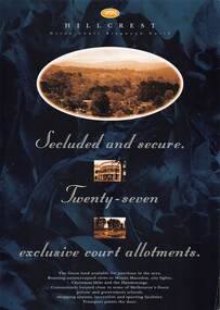
Flyer, Land Sale Advertisement, Hillcrest Heron Court, Ringwood North, Vic. - c.1994
Double sided A4 gloss print advertisement with subdivision map showing location and size of 27 residential allotments and A4 price list page for 14 Lots.Price list includes comment that "construction shall commence in September, with completion in December. Titles Office registration would be expected in January. (No mention of year/s, circa early to mid 1990s). -
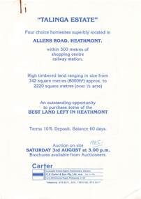 Ringwood and District Historical Society
Flyer, Land Auction Advertisement, Talinga Estate, Allens Road, Heathmont, Vic. - 1985
Double sided A4 page with subdivision map showing location and size of allotments for auction on Saturday 3rd August (1985). Agent - C.E. Carter & Son Pty. Ltd., 122 Whitehorse Road, Ringwood 3134, Telephone 870 6211.Handwritten sale price annotations - Lot 1 Sold $42,000, Lot 2 Sold $42,200, Lot 3 Sold $41,500, Lot 4 Sold $53,000. -
 Bendigo Historical Society Inc.
Document - CROWN LAND TRACINGS, BENDIGO, 1890 - 1910
Document: Crown land tracings, dark buff coloured foolscap paper tied with white tape. On front ' Crown Lands tracings 1890 - 1910'. Contains applications for crown lands, City of Bendigo, 1890 - 1910 including list of allotments, names of persons, locality and tracings of land referred to.crown land tracings, bendigo, sandhurst, land sales, crown land -
Merbein District Historical Society
Document, Papers regarding the Stephen Thompson Family, 1909+
conditional purchase lease- homestead allotment, stephen thompson, john coulter thompson, block, local land board - notes of evidence, application for property to local land board, map lot 52 (s. thompson) & lot 51 (j.c. thompson), house, eldora -
 Linton and District Historical Society Inc
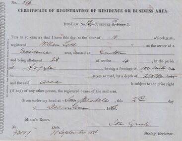
Certificate, John Ferres, Government Printer, Melbourne, Certificate of Registration of Residence or Business, William Todd, Linton, 1886, 1886
This certificate was issued to register William Todd as the owner of a residence area at Allotment 28, Section 4, Linton. This land was held under Miner's Right No. 93197. The certificate was issued at Smythesdale on December 2nd by John Lynch, Mining Registrar. Miner's Right No. 93917, 18 September 1886. The Todd family's first home is believed to have been at this site in Grantley Street. See photograph - Registration no. 465.Small blue-grey sheet of paper, black printed, handwritten detail.william todd -
 Bendigo Historical Society Inc.
Document - LANDS OFFICE: SANDHURST LISTS OF ALLOTMENTS SOLD 1854 - 1856, 1854 - 1856
Document: LANDS OFFICE: SANDHURST LISTS OF ALLOTMENTS SOLD 1854 - 1856 Sandhurst lists of allotments sold, dated 1854 - 1856. Sandhurst land sales outlying districts 1854 -1861. Loose pages in plastic pockets, blue lined, formerly in register that has degraded and not repairable. Lists of date of sale, no. of lot, parish, allotment, section, extent (size) purchasers name.Lands Officeland sales 1854, lands office, sandhurst, bendigo -
 Bendigo Historical Society Inc.
Document - LANDS OFFICE: SANDHURST AND DISTRICT LAND SALES 1865 - 1869, 1865 - 1869
Document: green hard cover journal with buff spine and corners. Contains details of land sales. Details on LH page: date, parish, section, allotment, area, applicant, val. asked. RH page: val. allowed owner of improvements., remarks. Dates range from 10th. January 1865 to 1869.Lands Officeland sales 1865 - 1869, sandhurst, bendigo, land sales, lands office. -
 Bendigo Historical Society Inc.
Document - LANDS OFFICE: CROWN LAND SALES 1855 - 1857, 1855 - 1857
Document: LANDS OFFICE: CROWN LAND SALES 1855 - 1857 brown hard covered journal with buff corners and spine. Contains 200 pages with details of crown land sales. LH page: lot, sec., allotment, county, parish, area, upset price, deposit, amount RH page: val. name of purchaser, name of owner of improvement, remarks.Lands Officeland sales 1855 - 57, lands office, sandhurst, bendigo, land sales, crown land -
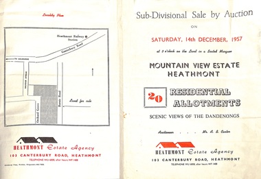 Ringwood and District Historical Society
Flyer - Land Sales Brochure, Sub-Divisional Sale by Auction - Mountain View Estate, Heathmont, Victoria - 1957
Bi-fold pamphlet advertising auction of 20 residential allotments on Saturday, 14th December, 1957, with description of services available and finance terms. Subdivision inclues Orchard Grove and Barnic Road. Agent - Heathmont Estate Agency, 103 Canterbury Road, Heathmont, Telephone WU6808, after hours WF1488. Auctioneer Mr. A.B. Carter. Accompanying Parish of Ringwood survey map with cardboard backing - Part of Crown Allotment 14B, includes handwritten price notations for each allotment. -
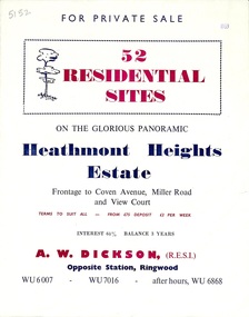 Ringwood and District Historical Society
Flyer, Land Sale Brochure, Heathmont Heights Estate, Heathmont, Vic. - 1959
Bi-fold advertisement for sale of residential sites, including map and summary of subdivision features and local facilities. Subdivision includes Coven Avenue, View Court, and Miller Road. Agent - A.W. Dickson, Opposite Station. (Phone) WU6007, WU7016, after hours WU6868. Accompanying Titles Office Plan of Subdivision photocopy dated 1971 - Part of Crown Allotment 38A Parish of Ringwood. -
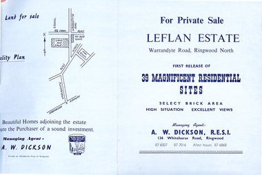 Ringwood and District Historical Society
Document - Folder, Land Sale - Leflan Estate, North Ringwood, Vic. - circa 1967
Bi-fold land sale advertisements for stages 1 and 3 releases of residential allotments in Leflan Estate, Ringwood North, circa 1965-1967. Brochures include area map, layout of the estate, and summary of local facilities and services, with separate attachment listing lot number prices for 2nd and 3rd releases.Subdivision includes Melview Drive, Leslie Grove, Leflan Close, Warrandyte Road and Lockhart Street. Agent - A.W. Dickson, R.E.S.I., 136 Whitehorse Road, Ringwood. (Phone) 870-6007, 870-7016, After hours 870-6868.