Showing 113059 items
matching road
-
 Eltham District Historical Society Inc
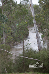
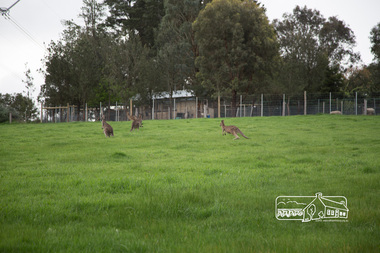
Photograph, Peter Pidgeon, Heritage Excursion; Laughing Waters, Laughing Waters Road, Eltham, 7 Sep 2013, 7 Sep 2013
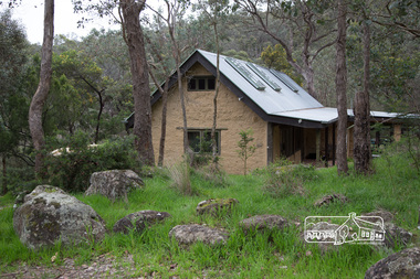
LAUGHING WATERS WALK This excursion was a follow up to the Laughing Waters Story told to us by Jane Woollard at our Annual General Meeting in March 2013. It involved a walk commencing from the corner of Laughing Waters and Overbank Roads along Laughing Waters Road to its eastern end and returning partly over the same route - a total distance of about 2.5km. On the way we visited the two artist in residence properties to view the houses on them that are associated with Alistair Knox, Gordon Ford and others in the local mud brick and artistic community. An unexpected afternoon tea was offered to us by the artists in residence and we had a brief opportunity to view inside one of the houses.Born Digitalactivities, eltham district historical society, heritage excursion, laughing waters road, eltham -
 Eltham District Historical Society Inc
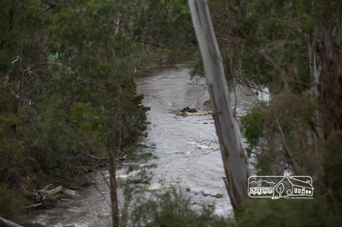
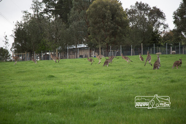
Photograph, Peter Pidgeon, Heritage Excursion; Laughing Waters, Laughing Waters Road, Eltham, 7 Sep 2013, 7 Sep 2013
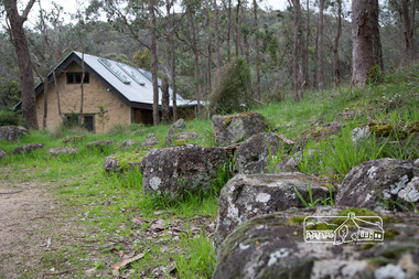
LAUGHING WATERS WALK This excursion was a follow up to the Laughing Waters Story told to us by Jane Woollard at our Annual General Meeting in March 2013. It involved a walk commencing from the corner of Laughing Waters and Overbank Roads along Laughing Waters Road to its eastern end and returning partly over the same route - a total distance of about 2.5km. On the way we visited the two artist in residence properties to view the houses on them that are associated with Alistair Knox, Gordon Ford and others in the local mud brick and artistic community. An unexpected afternoon tea was offered to us by the artists in residence and we had a brief opportunity to view inside one of the houses.Born Digitalactivities, eltham district historical society, heritage excursion, laughing waters road, eltham -
 Eltham District Historical Society Inc
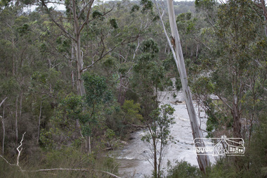
Photograph, Peter Pidgeon, Heritage Excursion; Laughing Waters, Laughing Waters Road, Eltham, 7 Sep 2013, 7 Sep 2013
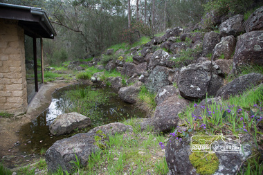
LAUGHING WATERS WALK This excursion was a follow up to the Laughing Waters Story told to us by Jane Woollard at our Annual General Meeting in March 2013. It involved a walk commencing from the corner of Laughing Waters and Overbank Roads along Laughing Waters Road to its eastern end and returning partly over the same route - a total distance of about 2.5km. On the way we visited the two artist in residence properties to view the houses on them that are associated with Alistair Knox, Gordon Ford and others in the local mud brick and artistic community. An unexpected afternoon tea was offered to us by the artists in residence and we had a brief opportunity to view inside one of the houses.Born Digitalactivities, eltham district historical society, heritage excursion, laughing waters road, eltham -
 Eltham District Historical Society Inc
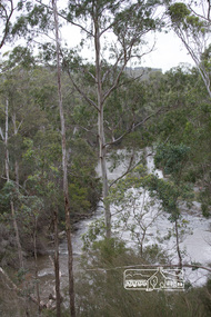
Photograph, Peter Pidgeon, Heritage Excursion; Laughing Waters, Laughing Waters Road, Eltham, 7 Sep 2013, 7 Sep 2013
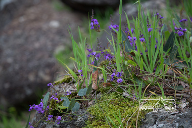
LAUGHING WATERS WALK This excursion was a follow up to the Laughing Waters Story told to us by Jane Woollard at our Annual General Meeting in March 2013. It involved a walk commencing from the corner of Laughing Waters and Overbank Roads along Laughing Waters Road to its eastern end and returning partly over the same route - a total distance of about 2.5km. On the way we visited the two artist in residence properties to view the houses on them that are associated with Alistair Knox, Gordon Ford and others in the local mud brick and artistic community. An unexpected afternoon tea was offered to us by the artists in residence and we had a brief opportunity to view inside one of the houses.Born Digitalactivities, eltham district historical society, heritage excursion, laughing waters road, eltham -
 Eltham District Historical Society Inc
Photograph, Peter Pidgeon, Heritage Excursion; Laughing Waters, Laughing Waters Road, Eltham, 7 Sep 2013, 7 Sep 2013
LAUGHING WATERS WALK This excursion was a follow up to the Laughing Waters Story told to us by Jane Woollard at our Annual General Meeting in March 2013. It involved a walk commencing from the corner of Laughing Waters and Overbank Roads along Laughing Waters Road to its eastern end and returning partly over the same route - a total distance of about 2.5km. On the way we visited the two artist in residence properties to view the houses on them that are associated with Alistair Knox, Gordon Ford and others in the local mud brick and artistic community. An unexpected afternoon tea was offered to us by the artists in residence and we had a brief opportunity to view inside one of the houses.Born Digitalactivities, eltham district historical society, heritage excursion, laughing waters road, eltham -
 Eltham District Historical Society Inc
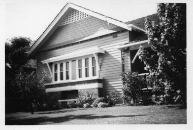
Photograph, Belle Vue, Livingstone Road, Eltham, c.1960, 1960c
Photo taken at time of ownership by Eric Staff. Originally purchased by pioneer Eltham farmer Henry Stooke, Belle Vue farm comprised about 56 ha (140 acres) extending northerly from the northern boundary of Holloway’s 1851 Little Eltham subdivision. On the present day map the southern boundary was just north of Elsa Court and Grove Street. The western boundary was the Diamond Creek and extended northerly to Main Road where it turns easterly towards Research. It was traversed by the main road to Kangaroo Ground and beyond and from 1912 by the railway to Hurstbridge. From 1895 the farm was owned by William Williams and his wife Mary Ann. In 1914-1915 they built a new house now known as “Belle Vue”. They sold the land in 1920 and residential subdivision began soon after that. “Belle Vue” remains today on a large residential lot in Livingstone Road. The house and many old trees on the site have been subject to a heritage overlay under the Nillumbik Planning Scheme. Despite that overlay, most of the heritage trees were removed during sub-division and development of the property.Digital file only from scan of copy on loan to EDHSbelle vue, eltham, eric staff, houses, livingstone road, staff family -
 Surrey Hills Historical Society Collection
Digital photo, George L Coop, 688 Whitehorse Road, Mont Albert c 1953, c1953
This was the home of 3 generations of the Coop family: 1. Josephine and George Frank Coop (noted in Box Hill Rate Books for 1947-1954). 2. George Burton Coop (1906-1960) and his family. He was Assistant Chief Architect of Victoria in the Public Works Department (P.W.D.) George Burton Coop was born in c1906 in Williamstown, the son of Josephine Vistarini and George Frank Coop. He married Winifred Alice Trewartha in 1936 and they are listed in the electoral rolls at 688 Whitehorse Road in 1937. George died 3/4/1960, aged 54 years at Mont Albert. 3. George Burton and Alice Coop had 2 children: George Lister Coop - born St Georges Hospital, 8/10/1937 Alison - born c1945. The donor George Lister Coop informed that he initially attended Chatham State School because his first home was the Spanish Mission style flats at 346 Whitehorse Road, opposite Brenbeal Street, Balwyn. When his grandparents died, the family moved to 688 Whitehorse Road and he then attended Mont Albert Central School. The California bungalow style of housing was the dominant style of housing built in the interwar period through the northern parts of Surrey Hills and Mont Albert as formerly semi-rural land was subdivided for new housing. It was relatively inexpensive and affordable. In Australia the Californian bungalow drew upon elements that were popular across the United States from around 1910 to 1939. In Australia the style became popular from 1913. In Melbourne both timber and red brick were used as the main building material. Typically they are one or one and a half story houses and feature sloping roofs and eaves with unenclosed rafters and often a feature a dormer window (or an attic vent designed to look like one) over the main portion of the house. Decorative elements include wood shingles, part stucco rendered exteriors, brick, stone, rendered or a combination of these treatments to exterior chimneys and front porches supported by heavy timber, brick or stucco columns.A black & white photo taken at an angle of a Californian bungalow.californian bungalow, whitehorse road, george frank coop, (miss) josephine vistarini, (mrs) josephine coop, george burton coop, (miss) winifred trewartha, (mrs) winifred coop, george lister coop, alison coop -
 Eltham District Historical Society Inc
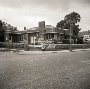
Negative - Photograph, Peter Bassett-Smith (poss), Shire of Eltham Office and Hall, cnr Main Road and Arthur Street, Eltham, c.1961
The Eltham Shire Hall and offices were opened on 21 November, 1941. They were replaced in 1965 with new offices at 895 Main Road and the site sold to Woolworths for development of the Eltham Village shopping mall. The building was demolished in 1970 and the new shopping mall opened in 1971. Negative black and white film 120 6x6 format and associated printFive frames sectioned; three continuous and two singleeltham, main road, arthur street, council, eltham hall, eltham shire council, eltham shire hall, eltham shire office, shire of eltham -
 Eltham District Historical Society Inc
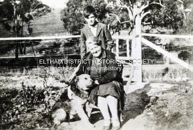
Photograph, Beatrice Arrowsmith (nee Quigley) and Robert Arrowsmith and King the dog at front gate of 523 Main Road, Eltham
View is looking south west from inside the front gate. Main Road is running across the picture just past the trees and the open area is where the current day Fitzsimons Lane runs. Porter street is adjacent to the property on the right of image. Robert was a POW in ChangiShows the area of Fitzsimons Lane prior to developmentBlack and white photograph - digital fileeltham, main road, fitzsimons lane, porter street, castledine, beatrice arrowsmith (nee quigley), king (dog), robert arrowsmith, joan castledine collection -
 Glen Eira Historical Society
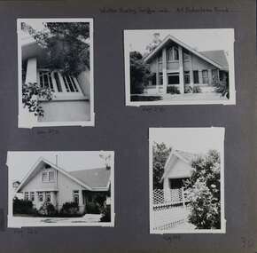
Album - Album page, Balaclava Road, 45, Circa 1972
This photograph is part of the Caulfield Historical Album 1972. This album was created in approximately 1972 as part of a project by the Caulfield Historical Society to assist in identifying buildings worthy of preservation. The album is related to a Survey the Caulfield Historical Society developed in collaboration with the National Trust of Australia (Victoria) and Caulfield City Council to identify historic buildings within the City of Caulfield that warranted the protection of a National Trust Classification. Principal photographer thought to be Trevor Hart, member of Caulfield Historical Society. Most photographs were taken between 1966-1972 with a small number of photographs being older and from unknown sources. All photographs are black and white except where stated, with 386 photographs over 198 pages. While the page heading says "Walter Burley Griffin arch", in fact Edward F. Billson designed it.From the Victorian Heritage Register Database - Citation for 45 Balaclava Road https://vhd.heritagecouncil.vic.gov.au/places/35562 (as at 12/10/2020) The house at 45 Balaclava Road, Caulfield North has architectural importance as an early example of the work of Edward F. Billson, whose work demonstrated the influence of the internationally distinguished American architect Frank Lloyd Wright and his one time colleague, Walter Burley Griffin with whom Billson worked in partnership for a period. It is presumed to be the earliest important example Billson's work and attains special importance as an early example of modern architecture in Australia, the earliest work of Griffin preceding it by only five years.Page 30 of Photograph Album with three photographs of the exterior of this double storey house and one photograph of a carport.Handwritten: Walter Burley Griffin arch. 45 Balaclava Road [top right] / Neg 272 [under top left photo] / Neg 270 [under top right photo] / Neg 262 [under bottom left photo] / Neg 264 [under bottom right photo] / 30 [bottom right] trevor hart, caulfield north, balaclava road, edward f. billson, frank lloyd wright, walter burley griffin, modern architecture, 1910's, gables, double storey houses, windows, attics, carports, gardens -
 Surrey Hills Historical Society Collection
Document, Copy of title, 391 Mont Albert Road, Surrey Hills
Victoria Melba Turner (known as Melba) and Elizabeth Maitland Anderson trained together at the Melbourne Hospital, completing their training just months apart; Melba in October 1914 and Elizabeth in May 1915. Both were registered on 31.3.1925 and listed at 391 Mont Albert Road, the site of Mosgiel Private Hospital. Note that the road was subsequently re-numbered and became 293 Mont Albert Road. 391 Mont Albert Road had previously been the home of the Sherar family and had originally been built for Charles J Currie, a solicitor. Three pages relating to the title of 391 Mont Albert Road. Historical search statement from Land Use Victoria is dated 15/09/2020. The reference is Vol 5414, Fol 1082747. 391 mont albert road, victoria melba turner, amy lillian hughes, muriel harper gilchrist, mosgiel hospital, 293 mont albert road, sherar family, charles j currie, quamby, elizabeth maitland anderson -
 Surrey Hills Historical Society Collection
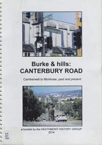
Book, Burke & hills: Canterbury Road, Camberwell to Montrose, past and present, 2014
Co-author Gerry Robinson was a speaker at a Surrey Hills Historical Society (SHHS) meeting. Lyndel Walker, member of SHHS, purchased the book for the collection. This book examines the changing landscape of Canterbury Road from the early days of settlement until today (2015)This book examines the changing landscape of Canterbury Road from the early days of settlement until today (2015)burke, surrey hills, canterbury, broughton park, vegetation, (mr) denis delaney, geology, (mr) john mcclare, geography, (mrs) mary mcclare, churches -
 Kew Historical Society Inc
Plan - Subdivision Plan, Argyle Road, Heather Grove, Victor Avenue, Kew, c.1937
The Kew Historical Society's map collection includes a substantial number of real estate subdivision plans, mainly of Kew but also of surrounding suburbs in Melbourne. Most of the subdivision plans date from the 1920s and 1930s when the districts old homes and local farmland were being split up to accommodate residential growth in the postwar period. These early plans were assembled by a local firm, Jas R Mather & McMillan, which had an office in Cotham Road. Many of the plans, and sometimes photos, were annotated by the agents.Subdivision plans are historically important documents used as evidence for the growth of suburbs in Australia. They frequently provide information about when the land was sold as well as evidence relating to surveyors and real estate and financial agents. The numerous subdivision plans in the Kew Historical Society's collection represent working documents, ranging from the initial sketches made in planning a subdivision to printed plans on which auctioneers or agents listed the prices for which individual lots were sold. In a number of cases, the reverse of a subdivision plan in the collection includes a photograph of a house that was also for sale by the agent. These photographs provide significant heritage information relating house design and decoration, fencing and household gardens.The photograph may also be aesthetically significant depending on the importance of the photographic atelier.Undated blue subdivision plan in Kew of 14 lots facing Argyle Road, Heather Grove and Victor Road. The Plan identifies Tuxen & Miller as the surveyors. [Formerly catalogued as MAP.0059]subdivision plans - kew, argyle road - kew, heather grove - kew, victor avenue - kew -
 Surrey Hills Historical Society Collection
Photograph, Kleinert family gathered fro Christmas celebrations at 34 Union Road, Surrey Hills
William was a coach-builder, wheelwright and blacksmith. He moved from Prahran to Surrey Hills to property owned by the family. The house at 34 Union Road was built in 1905 for William and his wife Emily. Their son Ernest worked with him as a coach painter and also worked as a painter undertaking intricate hand painting on early cars. Their other son Martin played for the Surrey Hills Football Club. In return for the support given to the club by Mrs Emily Kleinert, the club built a rotunda in South Surrey Park as a memorial to her. Alan Holt research: Lot 6 was sold to Martin Kleinert by Karl Richter in 1860 together with a portion of another adjacent lot. From 1860-1885 Martin worked it as a market garden leasing some land for grazing when it was not required for gardening. He died in 1898. In a formal document, William declared he was the son of Martin "who purchased land in 1860, died in 1898 and the land has been continually occupied by father and family since. It has been cultivated as a market garden; when not being used for gardening it was let for cultivation and grazing." William died in 1939 and the property passed to his sons Martin and Ernest. The Kleinert land extended from Union Road to Essex Road. They ran horses, ducks and fowls and Emily Kleinert grew flowers. The Kleinert property later became the South Surrey Park. The family sold the land to the Camberwell Council in the 1950s. Ernest and Ida Kleinert lived on the corner of Scotsdale and Warrigal Roads. The donor of the photo Nada Harris, nee Kleinert, was Ernest and Ida's daughter. Ida lived to a good age (> 93 years) and in later life lived in Burwood.Black and white photo of a large group of men, women and children posed for the photograph which is taken outdoors. William Kleinert is identified as seated in the front centre playing his German melodion. Sons Ernest and Martin and William's daughters Ivy and Rose are also in the photo (not identified). Nada Kleinert (daughter of Ernest and Ida and 1st grand-daughter of William and Emily) is standing next to her great-grandmother Radford.surrey hills football club, blacksmiths, wheelwrights, coachbuilders, south surrey park, rotunda, miss ida kleinert, emily kleinert, mr william kleinert, miss ivy kleinert, miss rose kleinert, mr ernest kleinert, miss nada kleinert, mrs nada harris, mr martin kleinert -
 Eltham District Historical Society Inc
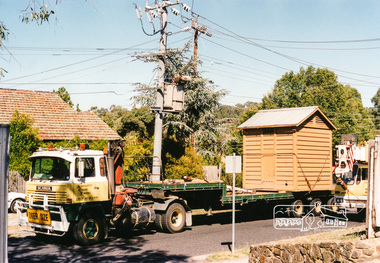
Photograph, Lock-up No. 17 arriving at the Local History Centre, 728 Main Road, Eltham, March 2001, March 2001
The portable lockup at Eltham is not original to the site. The date of construction is unknown, believed from the 1880s. It is a prefabricated design and each of the timber panels are individually numbered on the inside surfaces. It is amongst a large group of portable lockups, categorised as 'Portable Lock Up - Timber - Later' and also known as the "Casterton style", based on the only known plan for portable lock ups, built for the Casterton Police Station, in 1907. The later portables have been in use since the 1880s. It is not known how many lock ups of this type have been constructed in Victoria. At least 50 examples have been documented around the state. Of these, 42 are known to be extant. The original 1860s site lockup was a 2-cell bluestone construction. Some of the original bluestone remains. It was used in the 1970s as traffic island edging at the intersection of Main Road and Wattletree Road where it was painted white then later relocated back to this site in the 1980s to be used as edging for a driveway access off Main Road beside the former Police Residence where the Police Station originally stood. Evidence of some of this edging remains in place today leading to the replica Police Station. Other blocks were used to define the garden edging in the carpark at the rear of the residence.This lockup used to be located at the Police Station in Pryor Street and was then stored in Youth Road before being acquired for the Local History Centre 3 colour photographseltham, main road, police residence, local history centre, eltham district historical society, courthouse, youth road -
 Surrey Hills Historical Society Collection
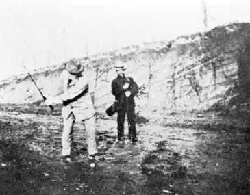
Photograph, Surrey Hills Golf Club - the cutting in (now) Whitehorse Road, 1905, 1905
Reproduced by permission of Mr John Arnold from his book: "The Riversdale Golf Club - a history, 1892-1977." Copyright to book: Riversdale Golf Club. Surrey Hills Golf Club operated from 1892-1908 then moved and became Riversdale Golf Club. The game was played across paddocks from Trafalgar Street, Mont Albert to Whitehorse Road and down Victoria Crescent to where Box Hill TAFE is now located in Elgar Road. There were problems with cows eating the tee flags! The clubhouse still exists as 30 Trafalgar Street. The men are standing on what is now Whitehorse Road in the cutting which can still be seen near the Box Hill Motel. Walter John Carre Riddell: Born c1859; died 12 March 1930; unmarried. Father came from Riddell in Scotland and took up land at Riddell's Creek, near Gisborne. W J Carre Riddell was educated at Melbourne Grammar, graduated in law from Melbourne University in 1882 and practised law until 1907. MLA for West Bourke for 17 years. Chairman of MMBW from 1907 until retirement in 1927. Versatile sportsman. REF: Obituary in Trove - The Argus, 13 March, 1930, p8.The image is significant for its association with Walter John Carre Riddell who was a significant identity in early 20th century Melbourne. His was well-known for his sporting prowess. In early life he was a keen footballer, cricketer and tennis player. In his later years he took up golf. Was President of Royal Melbourne Golf Club and Chairman of the Victorian Golf Association. The 'coffin hole' was a notoriously difficult position to play out from.Black and white photo of 2 men, one swinging his golf club; the other carrying a golf bag and watching. They are dressed in suits and hats and are standing in a cutting, the face of which shows rock strata."W. J. Carre Riddell playing out of the coffin, 1905."sports grounds, surrey hills golf club, riversdale golf club, jon arnold, w j carre-riddell, walter john carre riddell -
 4th/19th Prince of Wales's Light Horse Regiment Unit History Room
Film - DVD, Road To Tokyo
DVD in CaseRoad To Tokyothe last brutal year of ww2 in the pacific -
 Whitehorse Historical Society Inc.
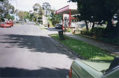
Photograph, Whitehorse Road, Mitcham - Service Road, 1/10/2000 12:00:00 AM
Coloured photograph of north Service Road in Whitehorse Road, Mitcham, looking west to shop and Service Station on the corner of Alexander Street Mitcham.service roads, whitehorse road mitcham, alexander street, mitcham -
Whitehorse Historical Society Inc.
Letter - Correspondence, WW2 army camp, Esdale Road, Nunawading, n.d
Note from Beryl Gray on an interview with Mr Mion of Haines St., Mitcham. Who stated that there was an army camp in Esdale Road, Nunawading during World War 2.Note from Beryl Gray on an interview with Mr Mion of Haines St., Mitcham who stated that there was an army camp in Esdale Road, Nunawading during World War 2.Note from Beryl Gray on an interview with Mr Mion of Haines St., Mitcham. Who stated that there was an army camp in Esdale Road, Nunawading during World War 2.mion, (mr), world war 1939-1945, esdale street, nunawading -
 Ringwood and District Historical Society
Photograph, Intersection of Warrandyte Road with Old Warrandyte Road and Tortice Dr. 1981
Written on back of photograph, "19/6/81. Looking south-west from intersection of Warrandyte Road with Old Warrandyte Road and Tortice Dr." -
 Ringwood and District Historical Society
Photograph, Junction of Warrandyte Road, Old Warrandyte Road and Tortice Drive, North Ringwood looking south 1981
Written on back of photograph, "19/6/81. The junction of Warrandyte Road, Old Warrandyte Road and Tortice Drive, North Ringwood looking south." -
 Ringwood and District Historical Society
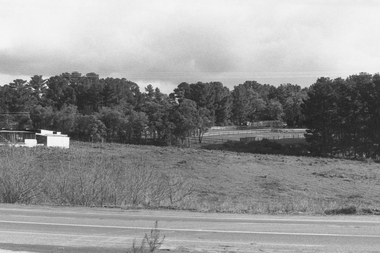
Photograph, Looking from Glenvale Road North Ringwood, across Glenvale towards Deep Creek Road 1982
Written on back of photograph, "21/4/82. Looking from Glenvale Road across Glenvale towards Deep Creek Road seen in distance." -
 Ringwood and District Historical Society
Postcard, View of Ringwood looking East from Warrandyte Road /Whitehorse Road intersection. Circa 1916
Sepia photograph on front of Postcard"Written on back of Postcard" View of Ringwood looking East from Warrandyte Road/Whitehorse Road intersection. Circa 1916. Presbyterian Church in foreground -
 Surrey Hills Historical Society Collection
Photograph, 'Glen Affric', 12 Durham Road, Surrey Hills, 1980s
Negative No 2121. Miss Jessie McCleverty operated a girls' high school at 12 Durham Road from 1903-1905/6. After this time she moved the school to 44 Windsor Crescent where it operated until 1933. Oral testimony from Mrs R McCoy: (NB/ It is unclear whether this refers to 12 Durham Road or 44 Windsor Crescent, but it is more likely to be the later as Mrs McCoy donated a photo taken in 1982 of 44 Windsor Crescent.) "She added school rooms and a veranda to the back. She was keen on Esperanto, the international language and wanted her pupils to know it. There was an archway over the gate, part of the design being a star, part of the Esperanto sign - and some suitable wording. Each morning the pupils greeting had to be "Good Morning Fraternity", in Esperanto."Colour photo taken front-on from the street of a Victorian-style house painted white and with ornate lacework along the veranda. It has a mature garden either side of a tessalated tile path.miss mccleverty's girls' school, victorian style, glen affric, miss jessie mccleverty, schools, durham road -
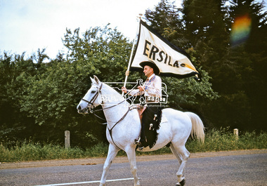 Eltham District Historical Society Inc
Photograph, Jock Read on 'Popeye', Ersilac Parade, Main Road, Eltham, c.1960, 1960c
Jock Read riding 'Popeye' south along Main Road approaching Bridge Street. Jock acquired 'Popeye' just before the outbreak of WW2. As he was already in the Royal Australian Navy, Jock named the horse after Popeye the Sailor Man. Popeye was a dapple grey, then went white as he aged. Digital file only (Wes's 35mm)don muir collection, eltham, ersilac, ersilac parade, jock read, main road, popeye (horse)